by Arnalie Vicario
Welcome to the 2024 OpenStreetMap Foundation Membership Campaign!
Today, members of the OpenStreetmap Foundation (OSMF) Board and several of the OSMF Working Groups are launching a worldwide OSMF Membership campaign with the goal of growing and diversifying OSMF membership in regions where there are no or very few OSMF members.
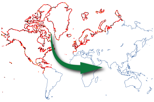
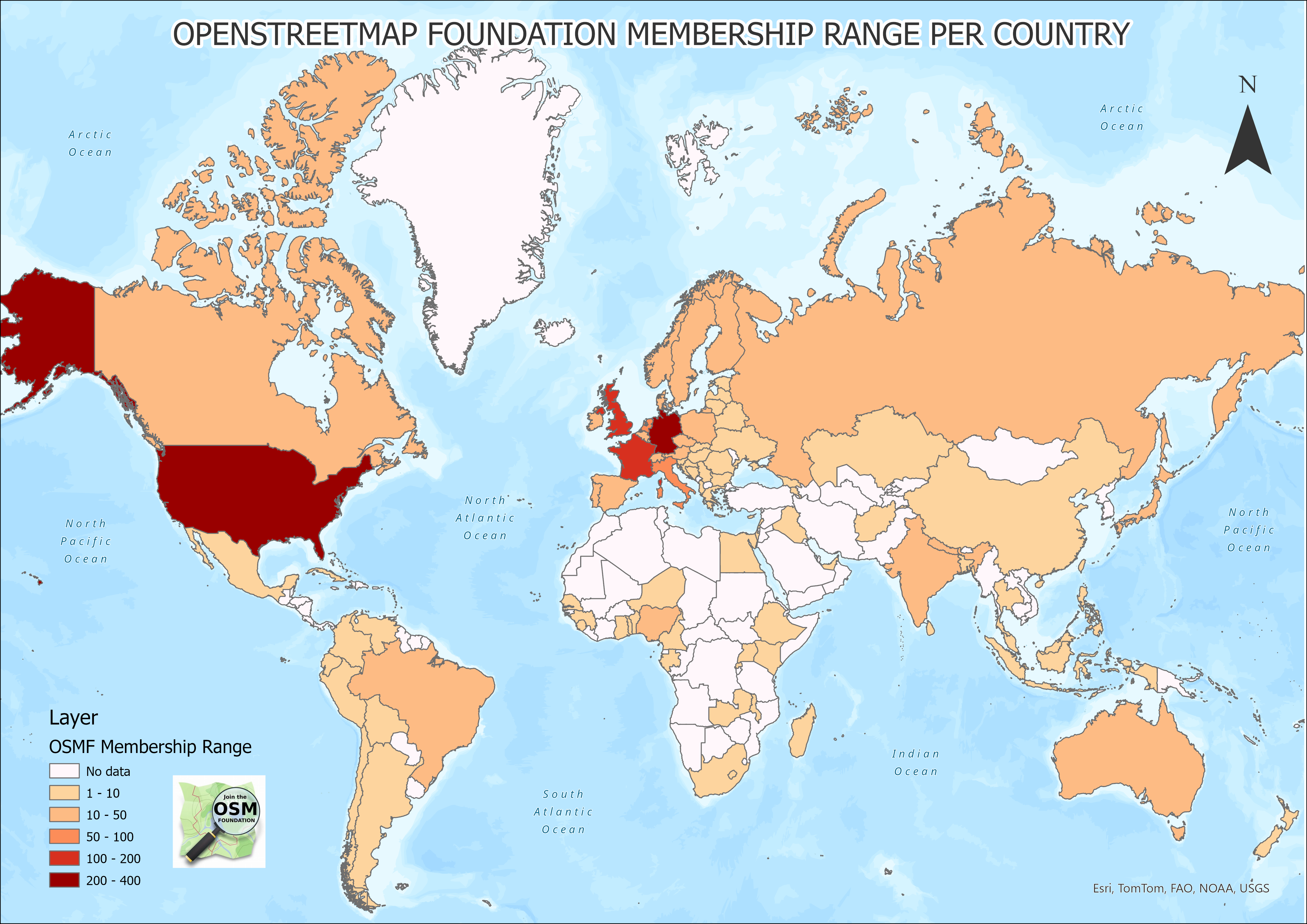
As you can see from this map, there are many such regions.
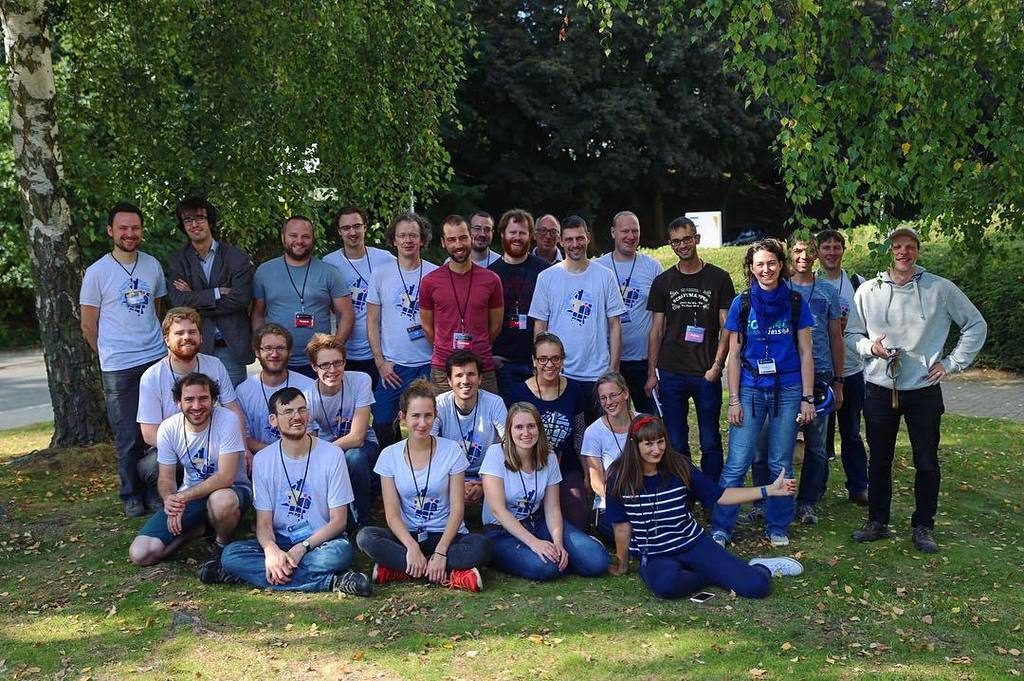
OSM is known for being built by a vast, global community of mappers, GIS professionals, community builders, developers, engineers, trainers, etc. over the last twenty years of the map’s existence, all of whom contribute their local knowledge and maintain open and free geospatial data.
The OSM Foundation administers and supports the making of OSM by overseeing OSM’s technological systems and data. It also helps steer the long-term strategy and well-being of the map.
So, it’s very important to have the membership of the OSM Foundation be reflective of the vast diversity of its community.
Why Do We Need an #OSMFMembershipCampaign?
As headlined on the OSMF website, the OpenStreetMap Foundation is dedicated to encouraging the growth, development and distribution of free geospatial data and to providing geospatial data for anyone to use and share.
It’s important to note that you don’t have to be a member of the OSM Foundation to make a profile on OSM.org and begin editing OpenStreetMap. You don’t even have to be a member to volunteer for a local community or a Working Group, or go to a State of the Map event or participate in a mapping party.
However, if you want to make a difference in the overall future of OSM, becoming an OSMF member is a good idea. For example, OSMF members are entitled to vote in the affairs of the Foundation, including to select members of the Board. OSMF members can also self-nominate for the Board. As you can see from its charter, the OSM Foundation values OSM contributors, and the OSMF membership exists to give dedicated contributors a voice in how the Foundation is run.
However, of 16 January 2024, there are just 1,929 OSMF members. This is a small percentage of the overall number of active mappers in OSM. (Pascal Neis has provided many resources, including this one, which show the data about the tens of thousands of people who are mapping at any one time and the millions who have mapped over the last 20 years.)
The fact that there are only 1,929 OSMF members means that just a tiny percentage of OSM’ers are electing the board and helping shape the OSM strategic plan and finances.
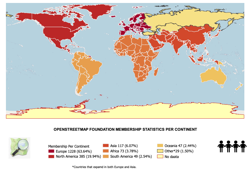
Further, here is the regional distribution of the 1,929 OSMF members.
To be successful at its goal to represent the interests of the OSM community, the OSMF must increase its membership in regions and countries where there are no or very few OSMF members.
The only way this will happen is if many thousands of OSM users decide to join the OSM Foundation as a member–TODAY!
What Are The Benefits of Being a Member of the OSMF?
- You get to play a direct role in choosing the leadership of the OSM Foundation. OSMF members vote every year at the Annual General Meeting, usually held in December, to elect the people who serve as volunteers on the OSMF Board. Importantly, you have to be a member in good standing 90 days before the election, so the time to join is now.
- If you’re a member during the 180 days before the General Meeting, you can self-nominate to serve as a member of the OSMF Board. This allows you to influence the strategic plan, some of OSM’s finances and other matters of governance.
- You show your support for the map and the community.
Here are additional reasons.
Please help shape the future of OSM by joining the OpenStreetMap Foundation
I Want to Help with the #OSMFMembershipCampaign
- Be a Campaign Ambassador!
- Post in your own social accounts and community channels about the Campaign! You can refer to the #OSMFMembershipCampaign Communications Plan.
- If you are already an OSMF member, share why OSM mappers should be a member and encourage OSM contributors to join as an OSMF member! Use the testimonial guide and upload your testimonials in the OSM Community Forum thread or email arnalie.vicario [at] osmfoundation.org
- Join the Team! Comment on the Call for Volunteers thread in the OSM Community Forum.
- We are specifically looking for volunteer translators who can help us translate into different languages, specifically:
- French
- Spanish (Juan)
- Arabic
- Portuguese
- Swahili
- We are also looking for help to explore other spaces where we can reach OSM community members, for example by organizing webinars, researching spaces e.g. podcasts where we can promote the campaign, and going live on social media (e.g. Facebook, TikTok, Instagram, etc.).
Here is the OSMF Membership Drive 2024 Plan on the OSM Wiki.
For any additional questions and comments, reach out to us via the OSM Community Forum thread.
We appreciate your help and look forward to growing and diversifying OSMF membership with you!
The OSMF Membership Campaign Team

The OpenStreetMap Foundation is a not-for-profit organisation, formed to support the OpenStreetMap Project. It is dedicated to encouraging the growth, development and distribution of free geospatial data for anyone to use and share. The OpenStreetMap Foundation owns and maintains the infrastructure of the OpenStreetMap project, is financially supported by membership fees and donations, and organises the annual, international State of the Map conference. Our volunteer Working Groups and small core staff work to support the OpenStreetMap project. Join the OpenStreetMap Foundation for just £15 a year or for free if you are an active OpenStreetMap contributor.