Having hosted the Olympic Games, Paris is now preparing to welcome another international gathering centered on community, openness, and diversity. Like the sporting disciplines themselves, OpenStreetMap’s mapping covers a multitude of themes and territories. Nature and hiking enthusiasts will find a space for expression there, as well as professionals in the field of geographic data.
Join us in Paris from August 28th to 30th, 2026, for State of the Map!
This annual gathering brings together OpenStreetMap volunteers, professionals, and enthusiasts to share knowledge, showcase innovations, and highlight the impact of open mapping.
Whether you’re a seasoned contributor, a curious newcomer, or a professional in the field, SotM 2026 is a chance for you to connect with the global community, learn about the latest developments, and contribute to the growth of OpenStreetMap. Mark your calendars and be part of this extraordinary event!
Save the date! Stay tuned via our website, 2026.stateofthemap.org for more updates on speakers, agenda, ticketing, and how to get involved as the event draws closer.
The State of the Map conference is the annual, international conference of OpenStreetMap, organised by the OpenStreetMap Foundation. The OpenStreetMap Foundation is a not-for-profit organisation, formed to support the OpenStreetMap Project. It is dedicated to encouraging the growth, development and distribution of free geospatial data for anyone to use and share. The OpenStreetMap Foundation owns and maintains the infrastructure of the OpenStreetMap project, is financially supported by membership fees and donations, and organises the annual, international State of the Map conference. Our volunteer Working Groups and small core staff work to support the OpenStreetMap project. Join the OpenStreetMap Foundation for just £15 a year or for free if you are an active OpenStreetMap contributor.
OpenStreetMap was founded in 2004 and is an international project to create a free map of the world. To do so, we, thousands of volunteers, collect data about roads, railways, rivers, forests, buildings and a lot more worldwide. Our map data can be downloaded for free by everyone and used for any purpose – including commercial usage. It is possible to produce your own maps which highlight certain features, to calculate routes etc. OpenStreetMap is increasingly used when one needs maps which can be very quickly, or easily, updated.
Do you want to translate this and other blogposts in your language? Please email communication@osmfoundation.org with subject: Helping with translations in [your language]
Have a bold, brilliant idea that could improve the OpenStreetMap (OSM) ecosystem? Got a vision for the future of OSM? Then we’ve got good news for you: the OpenStreetMap Foundation is thrilled to launch the 2025 edition of our Engineering Microgrants program!
This program is designed to support community members working on software projects that strengthen the OSM platform and ecosystem. We’re setting aside a total of £30,000, which may be distributed across several innovative and impactful projects. The per-project limit is £6,000, but if your idea goes beyond that, don’t hold back! The Engineering Working Group (EWG) may explore other funding avenues through the Foundation to help bring ambitious proposals to life. As such, we’d still encourage you to apply.
What’s the Process?
It’s simple and fair:
Submit your project idea via our GitHub template. This ensures transparency and reduces the chance of any conflicts of interest.
Our independent jury will review, score, and help select winning proposals through a multi-round process. Each idea will be reviewed not only for its score, but also for feasibility and implementation potential.
Pro tip: Before you hit submit, we strongly encourage all applicants to reach out to software maintainers if your idea touches existing tools, projects, or platforms. This helps align efforts, avoid duplications, and possibly even uncover opportunities for collaboration. If you need help identifying any software maintainers, you can contact the Engineering Working Group or the OSM Foundation Board, or ask directly on the announcement thread, so you can be put in contact with the correct parties.
Got questions? You can reply to the announcement thread, reach out to the jurors, or message the EWG directly. Jurors might also contact applicants during the review process if clarification is needed,so keep your inbox open.
We’re excited to see what you all come up with and submit! Whether it’s a tool to improve mapping workflows, enhancements to core OSM infrastructure, or entirely new ideas that fill a gap—we want to hear from you.
Submit your idea today and help shape the future of OpenStreetMap!
The OpenStreetMap Foundation is a not-for-profit organisation, formed to support the OpenStreetMap Project. It is dedicated to encouraging the growth, development and distribution of free geospatial data for anyone to use and share. The OpenStreetMap Foundation owns and maintains the infrastructure of the OpenStreetMap project, is financially supported by membership fees and donations, and organises the annual, international State of the Map conference. Our volunteer Working Groups and small core staff work to support the OpenStreetMap project. Join the OpenStreetMap Foundation for just £15 a year or for free if you are an active OpenStreetMap contributor
1. As a a member you can self-nominate to serve as a member of the OSMF Board. This allows you to influence the strategic plan, some of OSM’s finances and other matters that directly affect the direction of OpenStreetMap’s future.
This year’s OSMF General Meeting and board elections are 19 October 2024. This means that if you want to run for the Board you must become a member of the Foundation by 22 April 2024 There are FOUR Board positions up for election next fall. Even if you’re not sure that you want to run for the Board, but you think you might be interested, you should join!
2. If you are a member of the OSM foundation at least 90 days before the Annual General Meeting, you can vote in the annual Board elections,as well as on other foundation initiatives. The details on types of membership are here. Importantly, if you are an ‘active contributor’ you can apply for a free membership.
3. To help us grow and diversify the OSM Membership worldwide.
As you can see from this blog post, we are in the midst of a worldwide campaign to increase the number of OSM foundation members from all parts of the world. Right now, representation amongst OSM members is skewed toward the US and northern Europe, whereas there are many thousands of OSM contributors all over the world. By joining as a member, you can make the voices of the communities heard.
OSMF Board member Arnalie Vicario has been posting testimonials from current members on her X (and other accounts.). Here’s a video from Daniel Akor from OpenStreetMap Nigeria:
The OpenStreetMap Foundation is a not-for-profit organisation, formed to support the OpenStreetMap Project. It is dedicated to encouraging the growth, development and distribution of free geospatial data for anyone to use and share. The OpenStreetMap Foundation owns and maintains the infrastructure of the OpenStreetMap project, is financially supported by membership fees and donations, and organises the annual, international State of the Map conference. Our volunteer Working Groups and small core staff work to support the OpenStreetMap project. Join the OpenStreetMap Foundation for just £15 a year or for free if you are an active OpenStreetMap contributor
OpenUK celebrates Tom Hughes as one of the top open source contributors on their New Year’s Honours List. It is the fourth time the UK organisation for open technology publishes this list to honour open source influencers across the United Kingdom.
Tom is an OSM system administrator and one of the maintainers of the openstreetmap.org code. He has been maintaining and improving the website project since around 2006. His inclusion in OpenUK’s 2024 Honours List is a well-deserved recognition for almost two decades of hard work as a volunteer.
Congratulations Tom, and thank you for your unwavering dedication to OpenStreetMap!
Want to learn more about how Tom maintains the OpenStreetMap website project, and find out how you can help? Check out the “Maintaining OpenStreetMap.org” talk his fellow maintainer Andy Allan gave at State of the Map Europe 2023.
The OpenStreetMap Foundation is a not-for-profit organisation, formed to support the OpenStreetMap Project. It is dedicated to encouraging the growth, development and distribution of free geospatial data for anyone to use and share. The OpenStreetMap Foundation owns and maintains the infrastructure of the OpenStreetMap project, is financially supported by membership fees and donations, and organises the annual, international State of the Map conference. Our volunteer Working Groups and small core staff work to support the OpenStreetMap project. Join the OpenStreetMap Foundation for just £15 a year or for free if you are an active OpenStreetMap contributor.
By: Local Chapters & Communities Working Group (LCCWG)
The Local Chapters & Communities Working Group (LCCWG) tries to organize a yearly in-person and a yearly virtual Local Chapters Congress. For obvious reasons, events in 2020 and 2021 could only happen virtually. But in 2022 we managed to do both! This post covers about both the virtual and IRL (in real life) congresses.
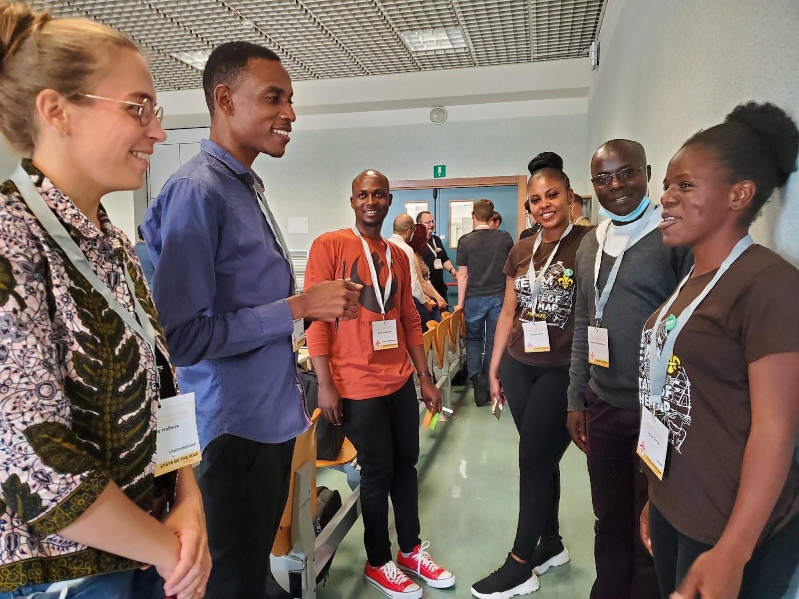
State of the Map Florence – Community Meet IRL!
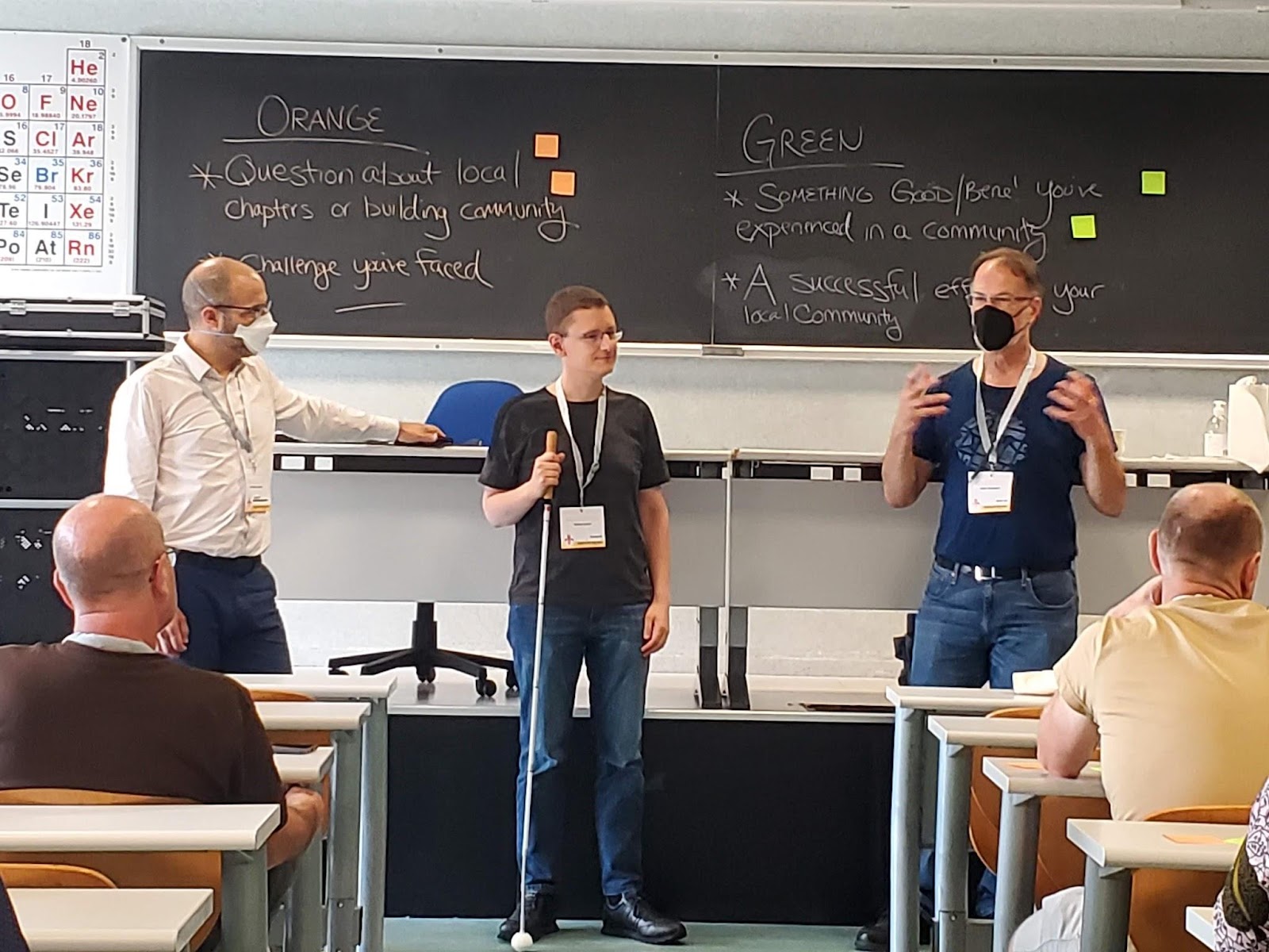
On August 19, at the State of the Map in Florence, Italy, the LCCWG hosted an in-person (woo hoo!) mini-Congress. If you missed it, here are some of the ideas that arose from a fruitful and fun discussion. We hope you will consider joining the next session in late 2023!
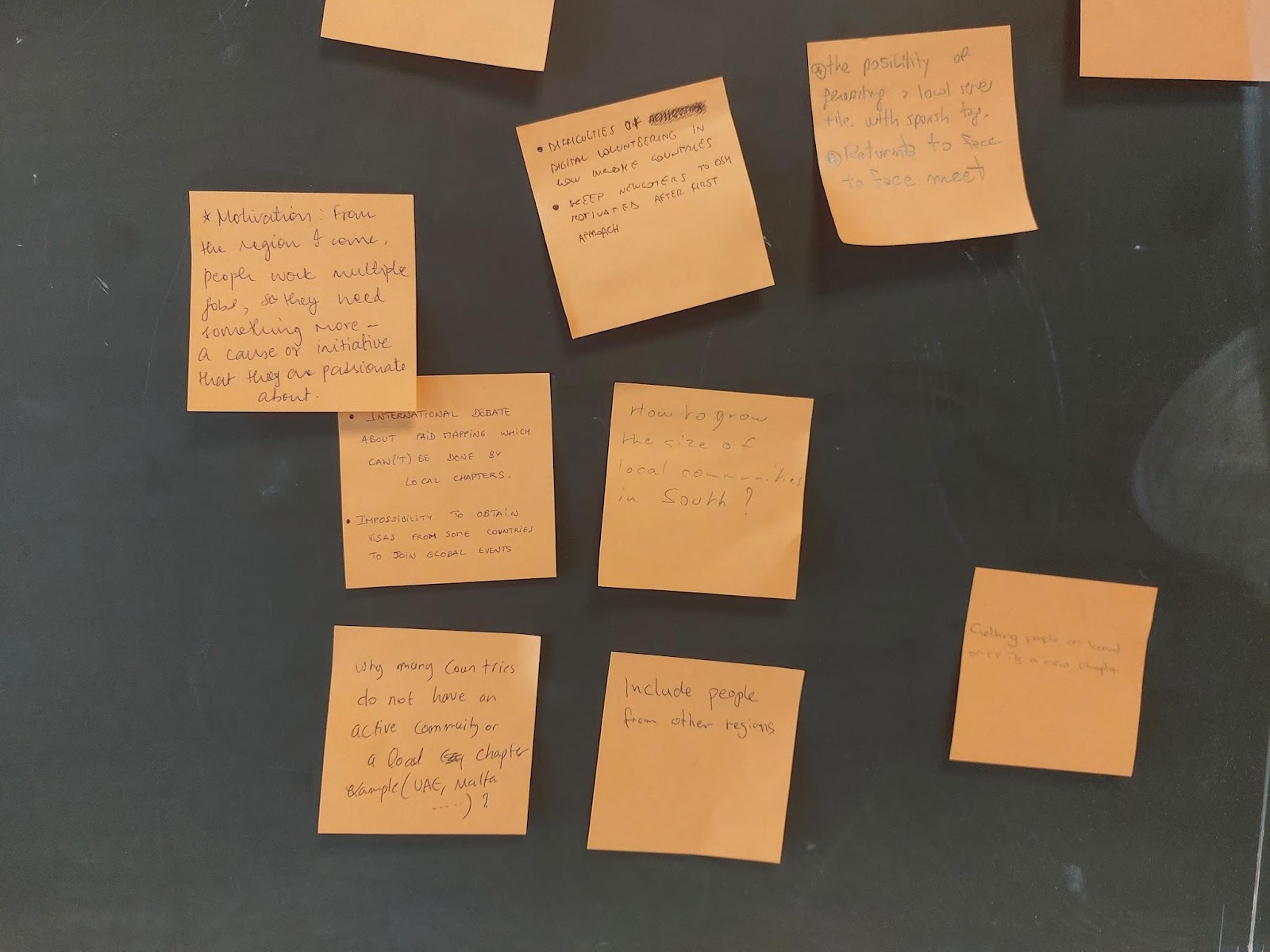
We started the session by dividing up into continents – and every continent was represented! It turned out many people from the same regions didn’t know one another.
Next we heard Allan Mustard, Tobias Knerr and Jean-Marc Liotier talk about the role of chapters from the OpenStreetMap Foundation perspective.
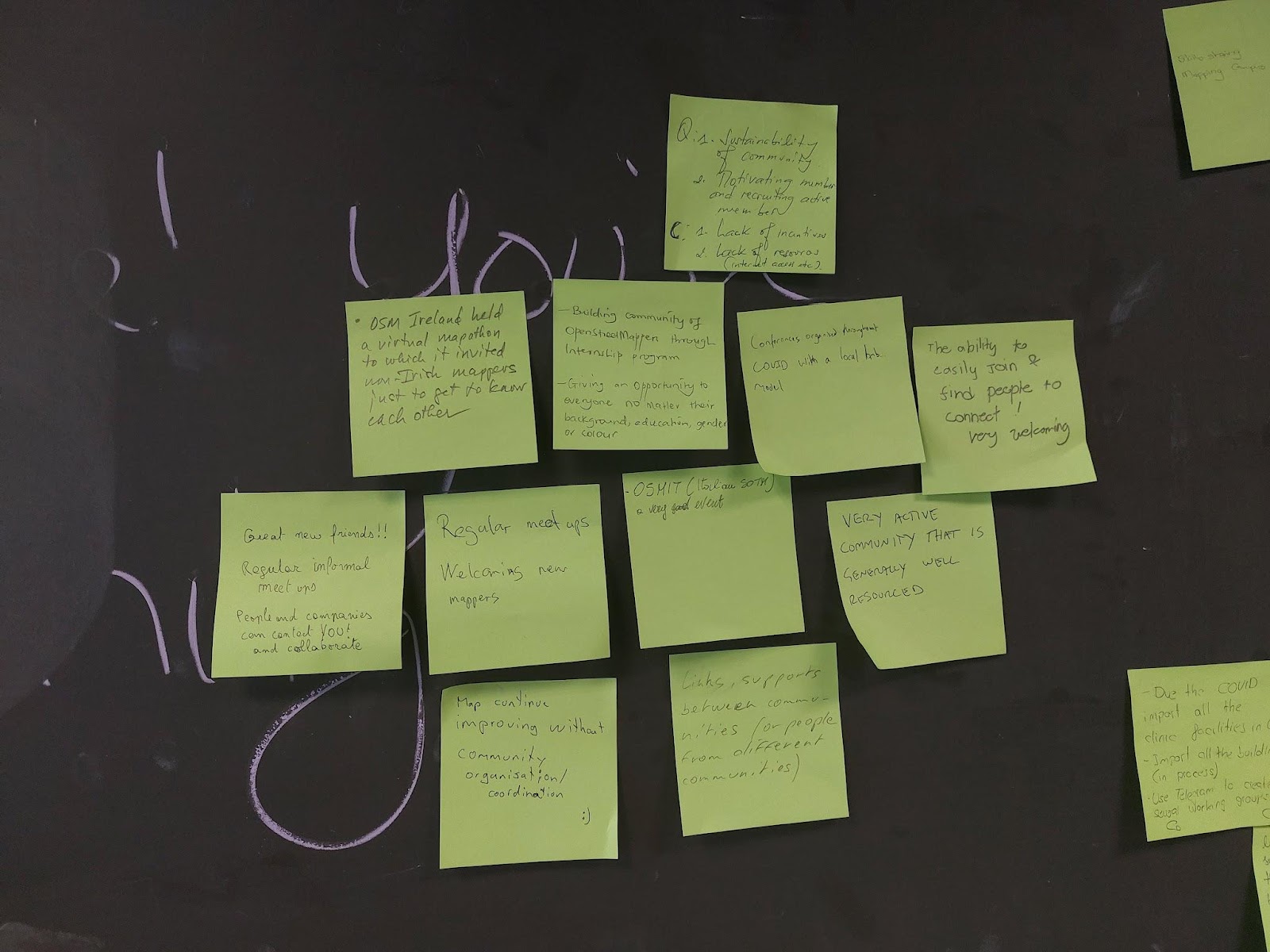
Next we passed out two colors of sticky notes and asked participants to share things that have worked in their communities or challenges they have faced. There were many great answers, and many common threads.
Where have you seen success gathering community?
In terms of having an organization, some groups found that having several dedicated chat rooms on specific topics helpful. Other groups found it simpler to move organizational stuff to open source software like Collabora, LibreOffice, LimeSurvey. Many folks had success linking with their local government and holding local events, like State of the Map. Other common threads were around community building and mapping projects. Community building around the world seems to have more success when the focus is on building relationships, working together with other communities and having regular informal meetings. All participants strive to keep their spaces open and welcoming.
Often communities are contacted by local authorities who want to help keep OSM data up to date. This can lead to partnerships for mapping projects, such as mapping health infrastructure for covid, mapping buildings and addresses, following up on Notes and just new mappers heading out to contribute on their own.
What’s Difficult About Organizing Community?
On the other sticky note, folks shared things that were more difficult. A general theme seemed to be growing pains – how do you get started? Once you have a little group, how do you formalize? When you become a Local Chapter, how do you find new goals for the community to work towards? In some regions, getting volunteer work at all is difficult. In others, it’s mostly about keeping people on board for longer.
Another common difficulty was the institutional and financial challenges associated with having a local group. How do you finance your organization? How do you handle commercial activities? In our session there were discussions about the limits to paid mapping by local chapters, the growing pains moving from an informal to a formal group, the procedure to become a Local Chapter and when requests from outsiders or handling management as a volunteer can be too time consuming.
Other challenges included how to decide between open channels Vs closed channels (where many folks tend to be already, like WhatsApp), having too many different channels, getting visas to attend global events, engaging volunteers in low income countries, and reconvening in-person after COVID.
When it comes to mapping – often that’s the least of a Chapter’s worries! Though in some countries, incentives for volunteers and lack of resources like decent internet connections are a barrier. Another challenge can be to get people facing the same direction to achieve common mapping goals, or to decide on which mapping tools to use. And there’s more and more quality open data that allows you to improve OpenStreetMap – but it is so much work to put it to use.
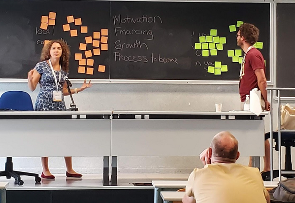
Local Chapters Congress – Community Meets Online
On November 12, 2022 the global OSM community gathered for the 3rd annual virtual Local Chapters and Communities Congress 2022. Leaders and members of various OSM communities, whether they are officially recognized Local Chapters of the OSM Foundation or just a regular user group of OSM mappers, came together to share stories and learn from each other.
There were lightning talks, presentations by LCCWG members and lots of great discussions. OSM Italia presented a fun video about the SotM in Florence. Adrés Gómez talked about how the Colombia community is successfully dealing with huge amounts of Notes – and how the project is expanding to other countries. Janet Chapman talked about Crowd2Map Tanzania. Then we heard about the new Discourse forum that lives at community.openstreetmap.org. To close off, we heard from a bunch of communities from around the globe.
The OpenStreetMap Foundation is a not-for-profit organisation, formed to support the OpenStreetMap Project. It is dedicated to encouraging the growth, development and distribution of free geospatial data for anyone to use and share. The OpenStreetMap Foundation owns and maintains the infrastructure of the OpenStreetMap project, is financially supported by membership fees and donations, and organises the annual, international State of the Map conference. Our volunteer Working Groups and small core staff work to support the OpenStreetMap project. Join the OpenStreetMap Foundation for just £15 a year or for free if you are an active OpenStreetMap contributor.
Tomorrow is International Women’s Day (IWD)–the perfect time to celebrate* the many women in OSM, as well as the contributions they make to the map and the community. And what better way to do this than to put a couple of these ladies in the spotlight: Geoladies PH.
(*Psssst: want to join other members of the community in honoring IWD? Scroll down to the end of this post for a list of celebratory mapping events you can still sign up for.)
The Philippine Geoladies group was established in 2019, when they held their first workshop at the Pista ng Mapa conference in Dumaguete. They “advocate for community diversity, collaborative participation, and affirmative spaces, especially for women and under-represented communities”. We had a chat with the core team to learn about all the activities they’re doing to work towards this goal.
Charmyne Mamador is leading Ausome Maps, a project funded by She Leads and She Inspires (SLSI). The SLSI program was launched by the Humanitarian OpenStreetMap Team’s (HOT) Open Mapping Hub – Asia Pacific at the end of 2021 and helped 100 women in multiple countries grow as leaders within their open mapping communities. Over the course of 6 months, they received training, mentoring and guidance in creating and leading a community project. At the end of the program, ten of these projects received funding, including Ausome Maps. The goal of Ausome is to map schools with special education (SPED) classes and therapy clinics in the Philippines. This will help the families of differently abled children find the support they need.
Another core member of Geoladies PH is Leigh Lunas, known as the group’s drone expert. She teaches students how to code and fly drones. Currently she is involved in the Bahaghari Maps initiative, aimed at creating usable trail maps for Philippine hikers.
Feye Andal is Geoladies’ Disaster Response Mapper and serves as a Regional Ambassador for YouthMappers in the Asia Pacific region. (Fun fact: in 2022, 45% of YouthMappers were women.) Recently Feye has been working with the UPRI (University of the Philippines Resilience Institute) YouthMappers on mapping and validating the areas affected by the Turkey and Syria earthquake.
Next up is Geolady Jen Alconis. One of her main projects has been to map all publicly accessible breastfeeding stations in the Philippines. This way, she could give back to her breastfeeding support group, but also to fellow mothers in general.
Geoladies PH member Andi Tabinas is the founder of Mental Health AWHEREness PH, a non-profit organization promoting mental health awareness through information, education, communication, and mapping mental health facilities and services.
Last but not least is Arnalie Vicario. Like her fellow ladies, she’s an advocate for diversity and inclusion, as well as for sustainable living and, at the end of 2022, she was one of the women elected to the OpenStreetMap Foundation Board.
Interested in learning even more about Geoladies PH? Check out their Facebook page.
Feel like meeting the ladies in real life? They regularly organize sessions and workshops to empower women to map. Tomorrow, on International Women’s Day, you will find them at the YouthMappers-organized Everywhere She Maps event in Manila (as well as online).
Of course, this is not the only mapping event dedicated to IWD. Below are some more opportunities to celebrate our female community members.
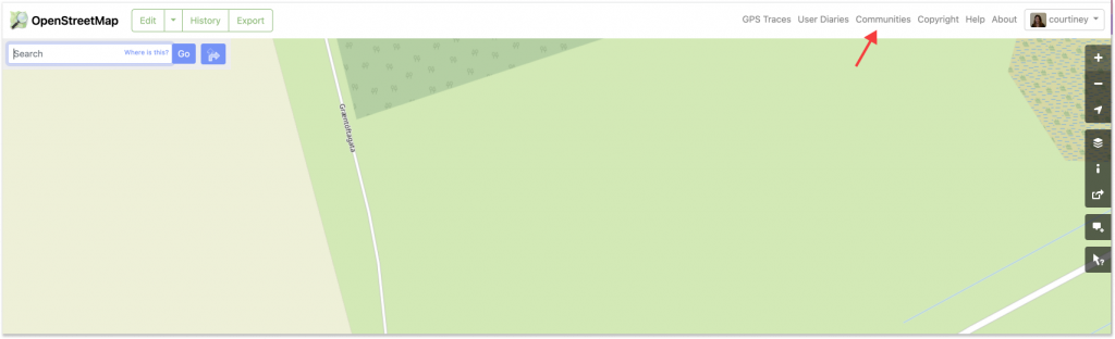
There’s a new way to find and connect with OSM communities.
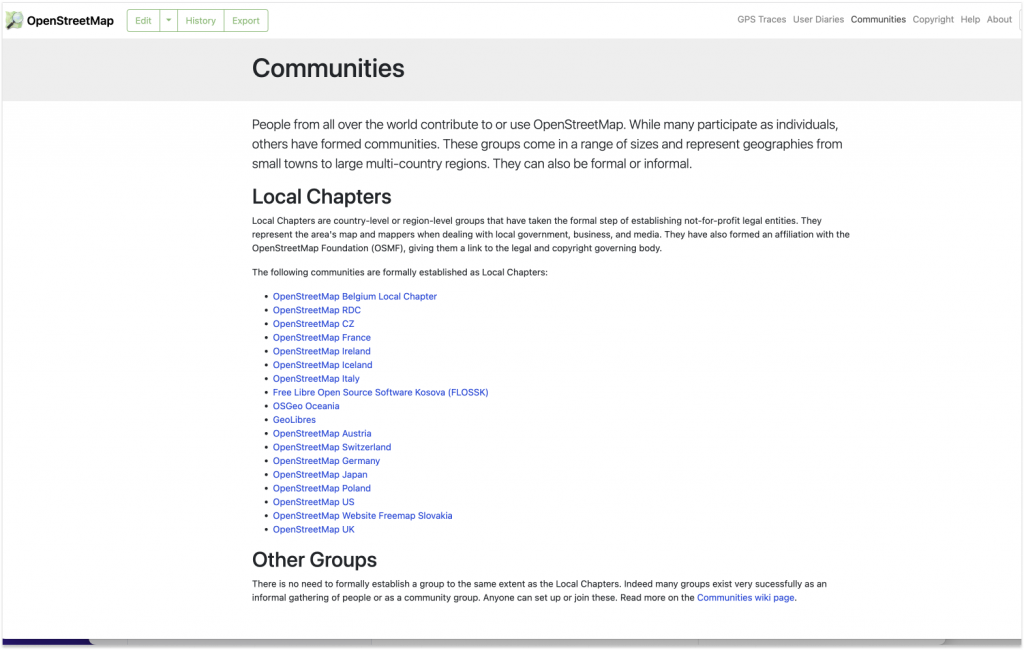
In the upper right corner of OSM.org, you can now see a “Communities” tab that links to a single, centralized location that lists formal Local Chapters, as well as the other OSM communities. Given how many communities there are and how fast OSM is growing, it’s a good time to add a prominent way to connect.
According to LCCWG member Joost Schouppe, the new tab “is probably the most visible change on osm.org since the addition of Notes.”
Once you have navigated to the new “Communities” page, you’ll see that the data for the Local Chapters listings is dynamically delivered via the OSM Community Index (OCI). In fact, the most difficult aspect of the project was figuring out how to integrate the OCI data into the page rather than just adding a simple list of Local Chapters as static content. As website maintainer Andy Allan noted, “The latter would have been quick and easy, but using the OCI means it is automatically updated when new Chapters are added, and it also means we are reusing all the translations for the Chapter names from the 46 different languages that we already support.”
While there is not currently a way to dynamically capture all of the other, less formalized communities, the addition of the “Other Groups” section highlights their existence and points the way to more information.
“It’s just a start” says LCCWG member Adam Hoyle, who also worked on the project. “Ideally this can grow into an even better centralized page for people and communities to find each other.“
Showing a list of Local Chapters is only scratching the surface of what can be done, now that the various underlying technical challenges have been solved. For example, when new mappers set their home location on their profile, they could be shown a list of local forums, mapping groups, and communication channels customised to their location could immediately be shown on their personal dashboard.
The key to shipping additional improvements to the “Communities” page is having volunteers to help out. ”All this community information is in OCI already, so we now need people to help expand our integration,“ says Allan. Schouppe adds that “this particular issue has been on the LCCWG agenda since October 2020, and Adam started working on it in January 2021. It goes to show that, because we are all volunteers, it takes a lot of time and effort to evolve the osm.org website, but it can be done.”
→ To contribute to the development of OSM.org, please visit the main Github and/or this issue, which highlights the many existing pull requests and gives ideas for how to contribute.
→ To help the LCCWG with their efforts to help local communities grow, please join one of their channels.
I’d like to thank Adam Hoyle for his work and patience while we worked through getting the technical foundations in place, which took a while but sets us up for the future; and also to the team behind OCI who made some changes to their side of things to help us get the translations fully working more easily. –-Andy Allan
The OpenStreetMap Foundation is a not-for-profit organisation, formed to support the OpenStreetMap Project. It is dedicated to encouraging the growth, development and distribution of free geospatial data for anyone to use and share. The OpenStreetMap Foundation owns and maintains the infrastructure of the OpenStreetMap project, is financially supported by membership fees and donations, and organises the annual, international State of the Map conference. Our volunteer Working Groups and small core staff work to support the OpenStreetMap project. Join the OpenStreetMap Foundation for just £15 a year or for free if you are an active OpenStreetMap contributor.
The launch of the Overture Maps Foundation is a significant development in the world of open map data. The founding members of Overture are influential tech industry leaders, and have committed a lot of resources. While many details of Overture remain unclear, the OpenStreetMap Foundation is interested to get a better understanding of the project. In the best scenario, OpenStreetMap would benefit from Overture’s advancements in software development, from the data and from funding. However, we also recognise risks, and will continue to develop our ability to grow the community and to fund our infrastructure and future development.
OpenStreetMap data is available for anyone to use, from hobby map makers to global corporations, and we encourage Overture to do the same, following our community expectations and licensing terms. The technical problems that Overture is addressing, such as quality checks, data integration, and alignment to schemas, are valuable for any map data provider. We know data consumers have been working on these challenges in isolation for too long, and by bringing these issues out into the commons, and open sourcing the tools, we can all benefit.
Following the announcement, we have had informal conversations with some people involved in Overture to ask questions and learn more. In particular, we asked about how work scoped in Overture overlaps with OpenStreetMap, and what the future involvement of member companies in OpenStreetMap will be. The answers have been helpful, though many questions remain. We have encouraged Overture to engage with our community and to share their plans publicly. We’ll share a few points here that were discussed informally.
Everyone we talked to emphasised that Overture is not intending to replace or fork OpenStreetMap. They see the work as complementary. The individual companies expect to continue working directly with OpenStreetMap, and may even increase their involvement, including financial contributions. Map edits that are right for OpenStreetMap, should go to OpenStreetMap. This stated commitment to OpenStreetMap’s work and community also suggests that the companies and Linux Foundation are on board to support OpenStreetMap financially. Overture has come together with a small group, and the intention is to grow and work out many details. They welcome OpenStreetMap involvement in the form that makes most sense.
The OpenStreetMap community has vast experience and knowledge in working with the diverse and complex realities of geographic data and compiling it into a unified global dataset. This knowledge can be supported but not replaced by automated approaches. We firmly believe that our community-driven approach to data collection will remain foundational to any global map. The mission of the OSMF to support the growth and development of OpenStreetMap community is more important than ever.
We encourage Overture to engage with the Foundation and the OpenStreetMap community, and make us a part of Overture’s strategic discussion holistically. Through good engagement, we can identify areas to collaborate and bring improvements to the core of OpenStreetMap, rather than creating duplicate or competing efforts. The resources that Overture’s founders are investing into the project, and their stated commitment to OpenStreetMap’s work and community, show the value they place on good maps, and the potential for supporting improvements in areas core to OpenStreetMap’s mission. We welcome Overture to discuss with the OSMF Board, and to explore the best ways to facilitate ongoing communication, decision-making, collaboration, and support.
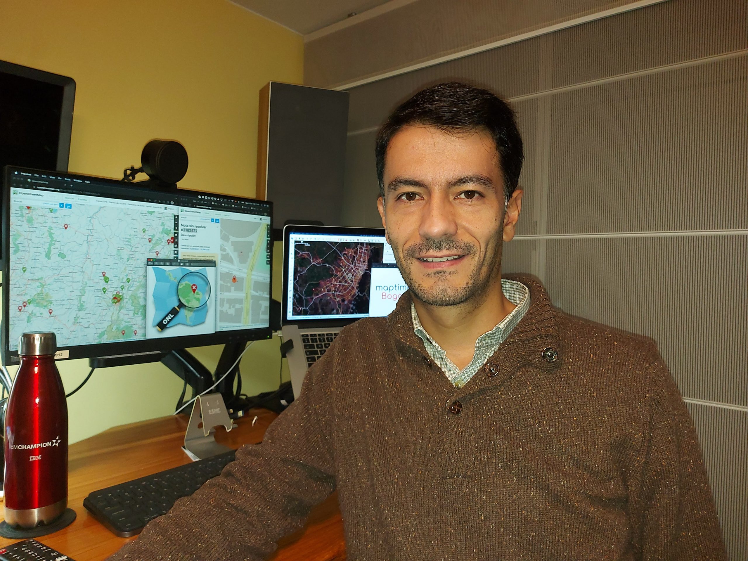
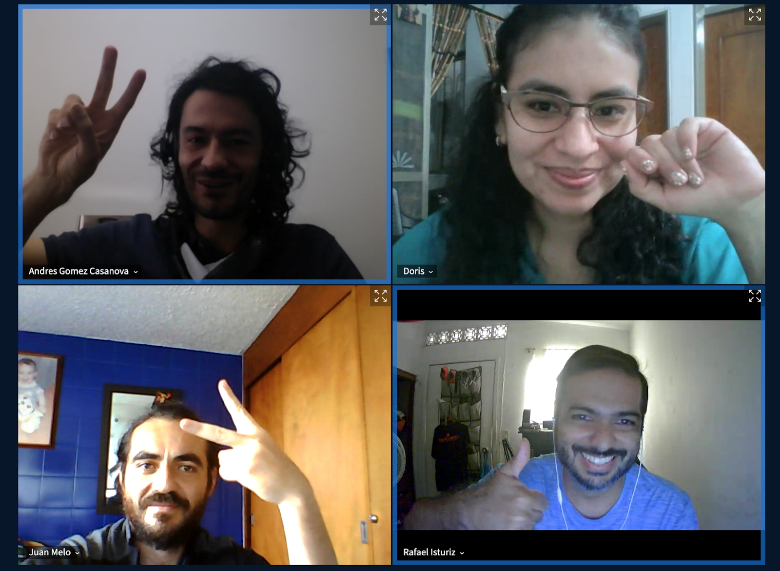
Notes is a core feature of the OpenStreetMap.org website. It enables you to add a comment on the map to assist others in mapping/editing OpenStreetMap. Other users can respond to your notes, for example to ask for additional details if necessary. Members of the OSM community in Bogotá in Colombia have been holding notathons – meetings to close pending OSM notes – and now they’re trying to help the various Latin American communities to do the same. Below is an interview of Andrés Gómez (OSM Colombia) by Juan Arellano (volunteer translator in the OSM Foundation’s Communication Working Group), conducted originally in Spanish and translated into English.
Juan Arellano – Hi Andrés, how and when did you become interested in OSM note resolution?
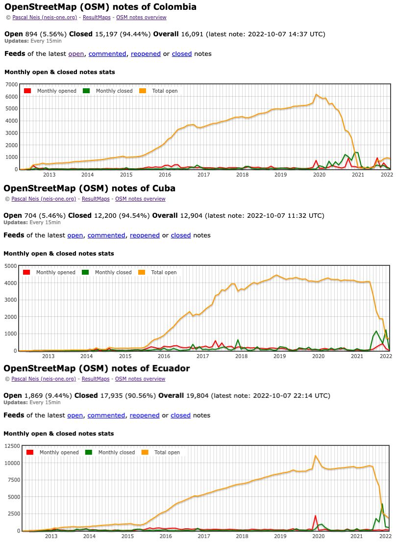
Andrés Gómez – I became interested when we were in lockdown due to the pandemic, with a lot of free time and unable to leave the house. It was the end of 2020, I was browsing Pascal Neis’ statistics page, and on the OSM notes overview page I saw that Colombia was really bad in terms of closed notes compared to open ones. This wasn’t so surprising as the Colombian community was not very active, and we had neglected this aspect.
So I read all I could find about notes, comments and how to solve them, but I didn’t find that much info. It felt a bit like when I started mapping in OSM… I was struggling to get started. It turned out that notes are a different layer, with their own process and flow, and I didn’t really understand their purpose.
However, after solving a few, I started to understand the mechanics. But solving 5,000 notes was a huge task! I tried to mobilise a group I had created years ago, MaptimeBogota. We had done mapping parties before, so I proposed virtual events, since we all had to be at home, and I waited to see what would happen. I had to be insistent. From May 2021 every Saturday at 11am I organised a virtual event. At first no one attended, but I kept insisting.
After several weeks, Doris Ruiz arrived, who knew about GIS, but not OSM, and we supported each other. Later came Rafael Isturiz, who knows about open source communities and IT administration, and I managed to convince him of the potential of the notes (now, he is the biggest note evangelist I know, and great things have been achieved thanks to him). Grigoriy Geveyler, who supported us in the dissemination of events then also joined the group, and obviously Juan Melo, who has become one of the great contributors worldwide. With such a group, the dynamics of solving notes improved, and we all learned a lot not only about notes, but also about OSM and GIS. In January of this year, we were able to announce the closure of all the old notes in Colombia.
JA – Do you use special tools for note resolution?
AG – At the beginning we only used the Pascal Neis tool, as we only wanted to solve the notes in Colombia. But once we completed this objective, Rafael proposed replicating the model in other countries. So, we started sharing the topic in the OSM Latam channel on Telegram and eventually organised a meeting, supported by Celine from OSM Mexico, to integrate the countries in the region. We already knew how to use tools like BigBlueButton, how to make presentations, how to disseminate via Meetup, so all the logistics were easy and the event got a good response from the community. Rafa proposed the idea of doing a ‘Notathon’, an event focused on the resolution of notes for any country, where multiple contributors could resolve notes in the same area together.
To develop the workflow for the notathons, we investigated other tools. NotesReview is good for a few notes in a given area. Anton’s OSM Note Viewer has had an impressive evolution, and we have requested some features from him via GitHub, and he has supported us in developing them. More recently, we have used the DAMN project to divide areas of interest, so that we can work collaboratively resolving notes in the same area without overlapping.
JOSM (Java OpenStreetMap Editor) is our preferred editor for resolving notes, and we have all shared our experiences of different plugins that can help in the note resolution process. For example, Erick de Oliveira’s notes for creating unmapped tracks are quite demanding, so Rafa proposed Fast Draw, and that helped us a lot to solve about 700 notes. Continuous download also allowed us to automatically download data from wherever the notes are, and so sped up resolution. We even found a couple of bugs in JOSM, and created their respective tickets in Trac. We have also requested other applications to incorporate notes functionality, such as FediPhoto and EveryDoor (which already did!).
JA – So, has the Latin American OSM community responded to your calls for notathons?
AG – Yes, and we have grouped all the notathons from the different countries in Latam in a Telegram channel. This is a first step, because there are people with more experience in notathons than us; for example, Felipe Eugenio from Chile, who has solved more than 8,000! Having a channel dedicated to notes has allowed us to work with focus on a specific topic. Some people who don’t participate in very active OSM channels, because they deal with so many different topics, prefer the Latam Notes channel because it is punctual and decisive.
In terms of participation in notathons, the community is a bit shy, and there are few newbie contributors arriving, but in a 1-hour event, such as the notathon in Cuba, around 100 notes are resolved. That’s a very high number, as we were all supporting each other, whilst asking Ghostsama, who was in Cuba, to clarify things for us from a local perspective.
We feel we have discovered new possibilities through notathons and we want more people to support and join us. We really think that, through the notathons, you learn a lot about OSM – in fact, when you go to solve a note, you don’t necessarily know what it will be about or what the user means, so you have to search, read, learn, and that’s it, you have evolved your knowledge and skills through OSM!
JA – What’s next for this project, any new ideas to implement?
AG – For me, the notes are the “voice” of the users of our maps, and we have to “listen” to them. We know that note resolution can be done collaboratively between people in the field and people contributing remotely, so one idea is to explore the potential use of notes in disaster response, where people on the ground can report what they see and, in real time, remote mappers can make modifications to the map. We have been thinking about doing a hybrid mapping party, where we would put this idea into practice.
OSM is also being used by platforms like Facebook or Instagram, and when our map is displayed on those social networks, there is the option to make a report. We would like these platforms to integrate these reports as notes, which would keep OSM more up to date. These companies could even deploy staff to solve the notes submitted by their users and, in this way, we all win.
To conclude, notes have been present for several years within OpenStreetMap and there are already several communities that believe in the importance of closing notes. I believe we are just discovering the potential of notes and that the appetite for them is growing – people from other communities are reaching out to us as they see us as a step ahead in this. We want to keep innovating with OSM notes, and for the community around them to grow!
JA – Finally, tell us a bit about yourself and your relationship with mapping and #openstreetmap.
AG – I’m a systems engineer. I have been working as a DBA for Db2 for more than 15 years. Data and databases have always interested me; that’s why OSM is of my interest. My relationship with OSM dates back to 2009, when I started drawing some nodes and lines near my parents’ house. I didn’t really know how to contribute and wasn’t aware of the governance mechanisms or the communities around me.
In Bogota they had just implemented a new transport system: the SITP. This system is much more structured than the chaotic old system, but with a major shortcoming to this day: it does not display information to its users! There are no maps on the streets, and boarding a bus can be a nightmare. It was at this point that I started to do a lot of research on OpenStreetMap: joining the community, reading the wiki, discovering applications, websites, services, etc. and this has helped me better understand the dynamics of the ecosystem.
Although I am passionate about it, transport is a complicated thing to implement, and requires a lot of effort, so I eventually put it aside. However, my interest in strengthening the OSM community increased, and I consider myself one of the leaders of the Colombian community, and I am also pushing the Latam community towards greater integration.