Tag Archives: OSM.org

Introducing the Communities Tab on OSM.org

There’s a new way to find and connect with OSM communities.

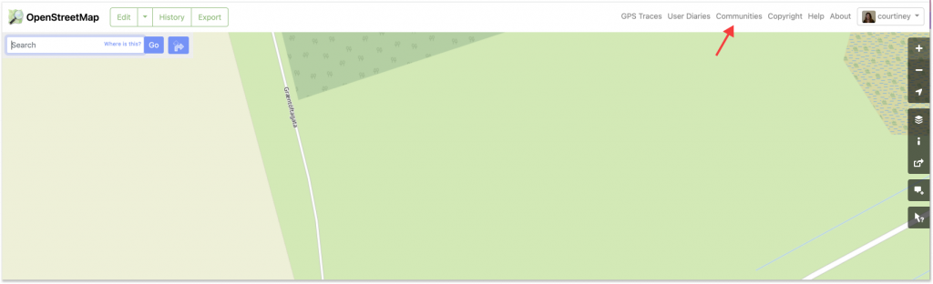
In the upper right corner of OSM.org, you can now see a “Communities” tab that links to a single, centralized location that lists formal Local Chapters, as well as the other OSM communities. Given how many communities there are and how fast OSM is growing, it’s a good time to add a prominent way to connect.

According to LCCWG member Joost Schouppe, the new tab “is probably the most visible change on osm.org since the addition of Notes.”

Once you have navigated to the new “Communities” page, you’ll see that the data for the Local Chapters listings is dynamically delivered via the OSM Community Index (OCI). In fact, the most difficult aspect of the project was figuring out how to integrate the OCI data into the page rather than just adding a simple list of Local Chapters as static content. As website maintainer Andy Allan noted, “The latter would have been quick and easy, but using the OCI means it is automatically updated when new Chapters are added, and it also means we are reusing all the translations for the Chapter names from the 46 different languages that we already support.”  

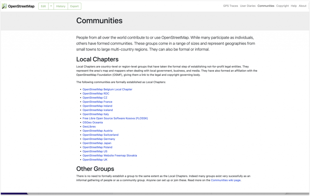
While there is not currently a way to dynamically capture all of the other, less formalized communities, the addition of the “Other Groups” section highlights their existence and points the way to more information.  

“It’s just a start” says LCCWG member Adam Hoyle, who also worked on the project.  “Ideally this can grow into an even better centralized page for people and communities to find each other.“ 

Showing a list of Local Chapters is only scratching the surface of what can be done, now that the various underlying technical challenges have been solved. For example, when new mappers set their home location on their profile, they could be shown a list of local forums, mapping groups, and communication channels customised to their location could immediately be shown on their personal dashboard. 

The key to shipping additional improvements to the “Communities” page is having volunteers to help out. ”All this community information is in OCI already, so we now need people to help expand our integration,“ says Allan. Schouppe adds that “this particular issue has been on the LCCWG agenda since October 2020, and Adam started working on it in January 2021. It goes to show that, because we are all volunteers, it takes a lot of time and effort to evolve the osm.org website, but it can be done.”

→ To contribute to the development of OSM.org, please visit the main Github and/or this issue, which highlights the many existing pull requests and gives ideas for how to contribute.

→ To help the LCCWG with their efforts to help local communities grow, please join one of their channels.

 I’d like to thank Adam Hoyle for his work and patience while we worked  through getting the technical foundations in place, which took a while but sets us up for the future; and also to the team behind OCI who made some changes to their side of things to help us get the translations  fully working more easily.-Andy Allan


The OpenStreetMap Foundation is a not-for-profit organisation, formed to support the OpenStreetMap Project. It is dedicated to encouraging the growth, development and distribution of free geospatial data for anyone to use and share. The OpenStreetMap Foundation owns and maintains the infrastructure of the OpenStreetMap project, is financially supported by membership fees and donations, and organises the annual, international State of the Map conference. Our volunteer Working Groups and small core staff work to support the OpenStreetMap project. Join the OpenStreetMap Foundation for just £15 a year or for free if you are an active OpenStreetMap contributor.

A new discussion forum for OSM

The OpenStreetMap Foundation is launching a new communication platform for the OpenStreetMap community at community.openstreetmap.org. Interested? Give it a try and find out how you can get involved with the next steps!

Screenshot of the new forum’s “feedback” category

Behind the scenes, the new space is powered by Discourse, a modern open source solution for online conversations. It is fully integrated with OSM accounts to let you log in with your existing user name. Discourse is easy to use and offers all the conveniences you would expect from social online spaces in the 2020s. At the same time, it gives power users access to optional advanced features: Write and receive posts through email, subscribe to RSS feeds, and more!

Of course, this is not the first platform dedicated to mappers’ conversations about their favourite passion. But while the new community space has been set up in parallel to the existing platforms provided by the Foundation (notably the forum, help site and mailing lists), we hope that the sub-communities on those platforms will eventually migrate to the new site. Likewise, we encourage communities currently using proprietary tools to consider adopting the new site for their communication needs. In particular, we are prepared to work with regional communities and local chapters – let us know on the Discourse forum what you need for your community to make this space your new home for discussing your local activities!

Choosing a solution that is hosted on our own infrastructure and based open-source software ties into the OpenStreetMap Foundation’s commitment to open communication channels. To ensure productive conversations and a welcoming environment, please respect our recently updated etiquette guidelines when you participate in the new forum. We hope that all members of the OSM community feel right at home at community.osm.org!

New Changeset display

The OpenStreetMap web site was updated today. When you view the history tab, you’ll now see a map with bounding boxes shown for recent changesets in the area. Hovering over the changeset will highlight the bounding box, and vice-versa.

This improvement was coded by Mikel and refined by Mikel and TomH.

Read more about this from Mikel’s announcement on his blog.

OpenStreetMap tile layer guidelines

mosaic of Modesto California, shown in four different tile styles.

Mosaic of Modesto, California, in four tile layer styles.

The image above was inspired, in part, by Firefishy’s April Fools Day joke, OpenWhateverMap. While such a map is unlikely to be used for an ordinary application, it does serve to show the wide variety of renderings of OpenStreetMap data that are created by the OpenStreetMap community and displayed on the OpenStreetMap web site. It also serves as an illustration of one of the frequently asked questions about the OpenStreetMap.org web site.

How are maps added to the OpenStreetMap web site?

Until December 2005, the OpenStreetMap web site did not have a map shown at all.

The OpenStreetMap main page in November 2005 had no map. (Courtesy Internet Archive)

Starting in December 2005, maps have appeared on the OpenStreetMap web site. Today, the slippy map is the most prominent feature of the OpenStreetMap web page. Currently there are four rendering layers that can selected on the front page as well as one overlay layer.

The OpenStreetMap Foundation now has published guidelines for tile layers to be considered for inclusion on the OpenStreetMap web page. If you know of an interesting rendering of OSM data, and you think it should be considered as a Featured Layer, add your suggestion to the featured tiles score card and start the discussion.

The proposed layers will be evaluated for suitability by the Technical Working Group, periodically, and the tile layer that you recommend could be featured on the OpenStreetMap web site.