In 2024, the OSMF Operations Working Group (OWG) is retiring OAuth 1.0a and HTTP Basic Auth on OpenStreetMap.org. These are technical ways for applications to authenticate users with the OSM website or API. OAuth 1.0a and HTTP Basic Auth have been deprecated since 2023, as OAuth 2.0 is now the standard authorization method for most systems.
There are three key dates in the transition process:
March 1st, 2024: New OAuth 1.0a application registrations were disabled. Existing applications were not impacted. HTTP Basic Auth was not impacted.
May 1st, 2024: System administrators will start brownouts to find applications that are still using OAuth 1.0a or HTTP Basic Auth.
June 1st, 2024: OAuth 1.0a and HTTP Basic Auth will be shut down.
Retiring these authentication methods is necessary because of security concerns, and the complexity of maintaining so many authorization implementations, including ones that rely on unmaintained components.
How does this impact me as a developer?
If you are a developer of an application using OAuth 1.0a or HTTP Basic Auth to log in to the OpenStreetMap.org website, you might need to make some changes to switch to OAuth 2.0. Fortunately, this is a well-supported industry standard.
If your application only makes read calls to the API, authorization is optional. For rate-limiting purposes, it is still a good idea to add authorization to your requests, but it is not required. If your application is a website using OSM for logins, making use of OAuth 2.0 is much easier as it is much better supported because so many other sites use it. It also avoids problems like users ending up with many tokens in their list on the website.
If you are developing software that edits using the API and is run locally, you may need to make code changes. All common languages have libraries that deal with OAuth 2, and libraries are the preferred choice for any authorization. You can also use Zverik’s library for command-line tools, or write your own shell script of about a dozen lines.
You should be able to find lots of examples online of OAuth 2 client implementations in your language. If you want to get more detailed information or ask technical questions, please use the GitHub ticket. Here, the OWG also tracks the applications requiring modification to use OAuth 2.0.
How does this impact me as a mapper?
Most mappers will notice no change. The transition will not affect how you log in to your OSM account or use the website. iD and JOSM have supported OAuth 2.0 as the default authentication method for some time. If you use your OSM account to log in to a third-party site like the HOT Tasking Manager, MapRoulette, or HDYC, you will not be impacted as those sites have already moved to OAuth 2.0. Read-only API access does not require authorization at all.
The OpenStreetMap Foundation is a not-for-profit organisation, formed to support the OpenStreetMap Project. It is dedicated to encouraging the growth, development and distribution of free geospatial data for anyone to use and share. The OpenStreetMap Foundation owns and maintains the infrastructure of the OpenStreetMap project, is financially supported by membership fees and donations, and organises the annual, international State of the Map conference. Our volunteer Working Groups and small core staff work to support the OpenStreetMap project. Join the OpenStreetMap Foundation for just £15 a year or for free if you are an active OpenStreetMap contributor.
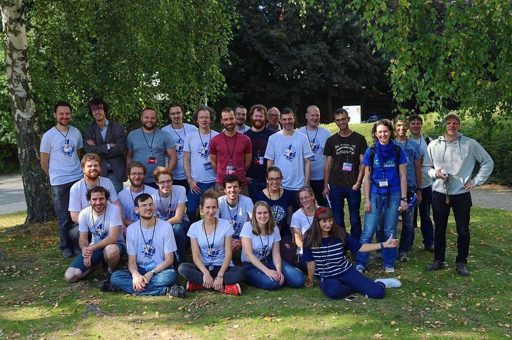
We would like to congratulate OpenStreetMap Belgium on becoming an OpenStreetMap Local Chapter (again)!
The past year was a rebuilding year for OSM.be. Regaining Local Chapter status was the cherry on top. The official status confers a seriousness and professionalism when working with outside organizations, and fosters leadership opportunities for OSM.be members when it comes to OSM Foundation policy making.
In a statement for this blog post, the OpenStreetMap Belgium Board noted that:
We had a tough 2023 when we had to reinvent ourselves as a separate organization. The good thing about that is that we’re now a much less complex organization. Furthermore, our bylaws now have legal standing, and we were able to set rules that better fit OSM-style leadership.
OSM.be’s goals for 2024 include promoting important mapping tasks and supporting member projects. They will also continue their camera grant project and keep working with Mapillary to distribute more 360° cameras across Europe. Another exciting project is to set up a Panoramax instance for Belgium. This project is in the relationship building stage as they seek to partner with governments and universities on servers.
Background
OpenStreetMap Belgium first became a Local Chapter on May 24th 2018. At that time, OSM Belgium was operating under Open Knowledge Foundation Belgium (OKFN). The Local Chapter agreement was terminated in September 2023 after OSM Belgium had resigned from OKFN Belgium. In November 2023, OSM Belgium re-applied for Local Chapter status as an independent organisation. The OpenStreetMap Foundation Board approved the application on January 25th 2024.
from https://openstreetmap.be/
Thank you to the OpenStreetMap Belgium community for spreading the good word about OSM, and educating people about the power of open data, local knowledge and community!
The OpenStreetMap Foundation is a not-for-profit organisation, formed to support the OpenStreetMap Project. It is dedicated to encouraging the growth, development and distribution of free geospatial data for anyone to use and share. The OpenStreetMap Foundation owns and maintains the infrastructure of the OpenStreetMap project, is financially supported by membership fees and donations, and organises the annual, international State of the Map conference. Our volunteer Working Groups and small core staff work to support the OpenStreetMap project. Join the OpenStreetMap Foundation for just £15 a year or for free if you are an active OpenStreetMap contributor.
OpenUK celebrates Tom Hughes as one of the top open source contributors on their New Year’s Honours List. It is the fourth time the UK organisation for open technology publishes this list to honour open source influencers across the United Kingdom.
Tom is an OSM system administrator and one of the maintainers of the openstreetmap.org code. He has been maintaining and improving the website project since around 2006. His inclusion in OpenUK’s 2024 Honours List is a well-deserved recognition for almost two decades of hard work as a volunteer.
Congratulations Tom, and thank you for your unwavering dedication to OpenStreetMap!
Want to learn more about how Tom maintains the OpenStreetMap website project, and find out how you can help? Check out the “Maintaining OpenStreetMap.org” talk his fellow maintainer Andy Allan gave at State of the Map Europe 2023.
The OpenStreetMap Foundation is a not-for-profit organisation, formed to support the OpenStreetMap Project. It is dedicated to encouraging the growth, development and distribution of free geospatial data for anyone to use and share. The OpenStreetMap Foundation owns and maintains the infrastructure of the OpenStreetMap project, is financially supported by membership fees and donations, and organises the annual, international State of the Map conference. Our volunteer Working Groups and small core staff work to support the OpenStreetMap project. Join the OpenStreetMap Foundation for just £15 a year or for free if you are an active OpenStreetMap contributor.
Tomorrow is International Women’s Day (IWD)–the perfect time to celebrate* the many women in OSM, as well as the contributions they make to the map and the community. And what better way to do this than to put a couple of these ladies in the spotlight: Geoladies PH.
(*Psssst: want to join other members of the community in honoring IWD? Scroll down to the end of this post for a list of celebratory mapping events you can still sign up for.)
The Philippine Geoladies group was established in 2019, when they held their first workshop at the Pista ng Mapa conference in Dumaguete. They “advocate for community diversity, collaborative participation, and affirmative spaces, especially for women and under-represented communities”. We had a chat with the core team to learn about all the activities they’re doing to work towards this goal.
Charmyne Mamador is leading Ausome Maps, a project funded by She Leads and She Inspires (SLSI). The SLSI program was launched by the Humanitarian OpenStreetMap Team’s (HOT) Open Mapping Hub – Asia Pacific at the end of 2021 and helped 100 women in multiple countries grow as leaders within their open mapping communities. Over the course of 6 months, they received training, mentoring and guidance in creating and leading a community project. At the end of the program, ten of these projects received funding, including Ausome Maps. The goal of Ausome is to map schools with special education (SPED) classes and therapy clinics in the Philippines. This will help the families of differently abled children find the support they need.
Another core member of Geoladies PH is Leigh Lunas, known as the group’s drone expert. She teaches students how to code and fly drones. Currently she is involved in the Bahaghari Maps initiative, aimed at creating usable trail maps for Philippine hikers.
Feye Andal is Geoladies’ Disaster Response Mapper and serves as a Regional Ambassador for YouthMappers in the Asia Pacific region. (Fun fact: in 2022, 45% of YouthMappers were women.) Recently Feye has been working with the UPRI (University of the Philippines Resilience Institute) YouthMappers on mapping and validating the areas affected by the Turkey and Syria earthquake.
Next up is Geolady Jen Alconis. One of her main projects has been to map all publicly accessible breastfeeding stations in the Philippines. This way, she could give back to her breastfeeding support group, but also to fellow mothers in general.
Geoladies PH member Andi Tabinas is the founder of Mental Health AWHEREness PH, a non-profit organization promoting mental health awareness through information, education, communication, and mapping mental health facilities and services.
Last but not least is Arnalie Vicario. Like her fellow ladies, she’s an advocate for diversity and inclusion, as well as for sustainable living and, at the end of 2022, she was one of the women elected to the OpenStreetMap Foundation Board.
Interested in learning even more about Geoladies PH? Check out their Facebook page.
Feel like meeting the ladies in real life? They regularly organize sessions and workshops to empower women to map. Tomorrow, on International Women’s Day, you will find them at the YouthMappers-organized Everywhere She Maps event in Manila (as well as online).
Of course, this is not the only mapping event dedicated to IWD. Below are some more opportunities to celebrate our female community members.
Last March saw the launch of the Pin je punt project (“Pin your point”). The aim of this tourism-focused mapping campaign is to augment OpenStreetMap with points of interest for hikers and cyclists, specifically in the Belgian region of Flanders. Pin je punt is a collaboration between Toerisme Vlaanderen/Visit Flanders (the region’s official tourism administration), the provincial tourism organisations and OpenStreetMap Belgium.
A partnership like this has a lot of potential to increase awareness about OpenStreetMap, and convince organisations and individuals to hop on the OSM train. So of course we wanted to know more. How did this collaboration come about? What has been achieved? And what can OSM as a community learn from a project like this?
To get an answer to these questions, we sat down with Pieter Vander Vennet (OSM Belgium) and Jos Pyck (project manager for Pin je Punt at Visit Flanders). This post is a reflection of those conversations.
Pieter Vander Vennet
Jos Pyck
What is the goal?
The Flemish tourism agencies want to enrich OpenStreetMap with as many points of interests as possible in the following categories:
Charging stations for e-bikes
(Public) toilets
Benches and picnic tables
Observation towers
Bicycle repair stations
Bicycle rentals
Playgrounds
The data should be complete enough so it can be used to improve route planning applications for hikers and cyclists, possibly even printed maps.
How did it start?
Back in the winter of 2020-2021, Visit Flanders was contacted by route planning developers looking for datasets to improve their services for cyclists and hikers. Triggered in large by the COVID pandemic, this target audience had grown into a large community with varying needs: hikers in search of public toilets now that restaurants and bars were closed, young families looking for playgrounds, e-bikers in need of charging stations, …
Unfortunately, no Flemish dataset was available to meet these requirements. The Flemish tourism organisations did have open datasets, but they were incomplete and spread across the five provinces. The solution? Using OpenStreetMap to unify, improve and maintain these different datasets.
Through the local cyclist organisation Fietsambassade Gent, Visit Flanders came into contact with Pieter Vander Vennet, who had developed the MapComplete editor and had already worked with a couple of government agencies. They formed a core working group with other OSM Belgium users Joost Schouppe and Seppe Santens (also ICT manager at the West-Flemish tourism organisation Westtoer, the only provincial agency with previous OSM experience). And just like that, Pin je punt was born.
How is the data added to OSM?
The existing datasets of the provincial tourism organisations were loaded and the objects converted into notes, which can be validated by users one by one. Of course new data points can be added as well. Validation and editing occurs in a custom theme in Pieter’s MapComplete tool, enabling users to edit specific POI categories in OSM in a user-friendly way. This makes it the perfect fit for the Pin je punt campaign, which is also aimed at users without OSM experience. Visit Flanders invited all Flemish province and municipality employees to start editing, and even launched a media campaign to reach the general public. (The promo video featuring a former Flemish radio presenter (in Dutch only) is, as far as Pieter knows, the first professional commercial encouraging contributions to OpenStreetMap!)
Of course, as new users are attracted, it is important to keep an eye on the quality of their work. For that reason, volunteers of the Belgian OSM community monitor the edits made in Pin je punt.
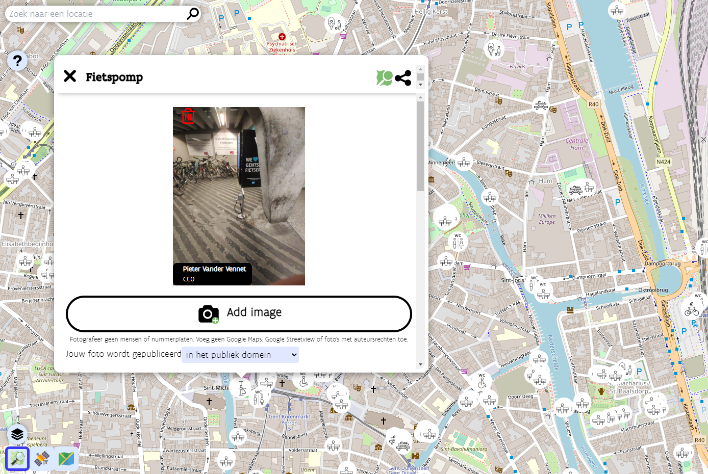
A bicycle pump in the Pin je punt MapComplete theme
What are the results and takeaways?
The Pin je punt campaign officially concluded at the end of April 2022. During the 1,5-month-long project run, the imports of the provincial datasets and the edits made by many tourism organisation employees and other users resulted in about 1,500 new points being created in OpenStreetMap. Since the Pin je punt MapComplete theme remains available, these users can continue to improve the data in their municipalities.
But the potential effects of Pin je punt extend far beyond an increased number of POIs for hikers and cyclists. The campaign also has the capability to increase awareness about OpenStreetMap and its possibilities outside of the OSM community, and to encourage more organisations to start using OSM.
Pin je punt has convinced one person in particular of OpenStreetMap’s strengths: project manager Jos Pyck of Visit Flanders. He used to be sceptical about using OSM, as he–despite his GIS background–deemed it far too technically complex. But this campaign has turned him into a true OSM believer. He’s impressed by the sheer size of the database and the fact that anything can be captured in it. And his pleasant experience with the helpful community even resulted in Visit Flanders becoming a corporate member of OSM Belgium.
Jos is very interested in expanding the Pin je punt theme with more tourism-related layers in the future, for instance bars, restaurants, drinking fountains, … He has even made it his mission to encourage other government agencies and municipalities to invest (more) in OSM, instead of setting up and maintaining their own limited, siloed databases. The five provincial tourism organisations involved in Pin je punt are already on board. Four of them had no previous experience with OpenStreetMap, and this project convinced them that the OSM community can produce a dataset superior to theirs. The experience really lowered the barrier for them to use OSM again in the future. Hopefully the results of Pin je punt can win over other public organisations as well.
Collaborations like these can also be a learning experience for the OpenStreetMap community. As a former outsider, Jos Pyck had some interesting insights to share. Though he is now an avid fan of OSM, he still believes it is difficult for newcomers to start using the map, as they are intimidated by how technical it looks. This outsider perspective had a positive impact on the look and feel of the MapComplete theme created for Pin je punt. While Jos’s team members were trying out the first versions of the theme, they formulated some comments about the user-friendliness of the tool. Pieter Vander Vennet took their feedback to make the tool as simple, easy to use and promotable as possible. Note that it can be reused outside of Flanders–the project team already saw some edits popping up in the rest of Belgium, the Netherlands, France, the UK, …
One particular observation Jos made while venturing into the world of OpenStreetMap, is the small number of women in the community. He points out that his colleagues who tested the MapComplete theme were all female and therefore had a different perspective on usability, which helped tweak the tool substantially. According to Jos, OSM would very much profit from getting more women on board.
Want to find out more?
This blog post points to many interesting links providing more information about the Pin je punt project and the people involved. If you have any additional questions, feel free to reach out to Jos Pyck, Pieter Vander Vennet and Joost Schouppe at pinjepunt@toerismevlaanderen.be.
Want to contribute?
Though the Pin je punt project officially concluded at the end of April, all contributions to help cyclists and hikers in Flanders are still very much welcome. So don’t hesitate to head to the Pin je punt MapComplete theme (in Dutch only) and start mapping!
Do you want to translate this and other blog posts in another language? Please send an email to communication@osmfoundation.org with the subject: Helping with translations in [language]