Category Archives: Uncategorized

Mappers, Universities, Companies, and nonprofits Contributed Over £373,000 to Support OSM in 2023

Last year, the global OpenStreetMap community, together with OSM’s corporate members and partners, donated an astounding £373,000 to support the map.

In an extraordinary show of support for OSM’s 19th birthday, the mapping community contributed over £113,000 through small donations. This enthusiastic broad base of community support resulted in approximately 3,089 donations from all over the world averaging £36 each. The OSM fundraising committee is especially grateful for the social media shares and the kind and encouraging comments on supporting.openstreetmap.com, in addition to the gifts. The positive response to the birthday fundraising campaign was a  highlight of the year. Thank you! 

OSM’s corporate partners also played a pivotal role, with total corporate memberships reaching £201,074. Additional, generous gifts, above and beyond corporate membership fees, from Microsoft, NextGIS, Smoca, and Elasticsearch helped bring us to the £373,000 total. We are also grateful to the corporate Advisory Board for their advice and collaboration which has been essential to the success of our partnerships.Thank you!

A special note of thanks goes out to NextGIS, which has pledged 10% of its profits from data sales to OSM, setting an impressive standard for its commitment to the project.  

In an extraordinary show of support for OSM’s 19th birthday, the mapping community contributed over £113,000 through small donations. This enthusiastic broad base of community support resulted in approximately 3,089 donations from all over the world, averaging £36 each.

OSM is fortunate to be the recipient of mission critical, “in kind” support through donations hardware and other infrastructure. We are grateful to Fastly, who provide the content delivery network for the file service, and many others, including TomTom, Bytemark, AWS and University College London, as well as AARNet, AWS,Academic Computer Club, Umeå University, Appliwave, Bytemark, Equinix Amsterdam, Equinix Dublin, Exonetric, INX-ZA, NetAlerts, OSUOSL, OVH, and Scaleway and everyone else who contributes to OpenStreetMap.

We’d also like to add a special note of thanks to  Kevin Bushaw, who gave us a steep discount on our new website, supporting.openstreetmap.org.

The funds raised  in 2023 will go toward enhancing infrastructure, supporting our critical support staff including our SSRE, and helping build OSM into the future.

On behalf of OSM’s local communities, the OSMF board would like to thank the companies who sponsored SotMs in 2023, both regional and local. This kind of support is very important to local communities, because the OSMF itself cannot promise companies that their funding goes towards regional events, except where the money is earmarked as part of a Sponsorship Distribution Agreement. Companies who directly support regional events are making a positive difference for the community and the quality of the map.

Lastly, we want to point out that any generosity toward OpenStreetMap is generosity to the broader open source software and data community, not just the OSM project. The impact of your gifts extends far beyond the financial; it is a commitment to a world where open data serves as a cornerstone for creativity, problem-solving, and community building.

Thank you for supporting OpenStreetMap!


The OpenStreetMap Foundation is a not-for-profit organisation, formed to support the OpenStreetMap Project. It is dedicated to encouraging the growth, development and distribution of free geospatial data for anyone to use and share. The OpenStreetMap Foundation owns and maintains the infrastructure of the OpenStreetMap project, is financially supported by membership fees and donations, and organises the annual, international State of the Map conference. Our volunteer Working Groups and small core staff work to support the OpenStreetMap project. Join the OpenStreetMap Foundation for just £15 a year or for free if you are an active OpenStreetMap contributor.

Nominate yourself for the OSM Foundation Board Elections by October 22!

The OpenStreetMap Foundation logo

Here’s an opportunity to get involved in the OpenStreetMap Foundation, the nonprofit that supports the OSM project!

The OpenStreetMap Foundation Board elections are coming up in December, and there are three seats that will be open. If you’re interested in running, the deadline to nominate yourself is coming up, October 22, 2022 at 23:59 UTC.

About the OpenStreetMap Foundation Board of Directors

The seven-person Board of Directors works on OSM Foundation matters on a volunteer (unpaid) basis and is elected by the OSM Foundation membership.

The board meets regularly to work on administrative, policy, and fundraising issues, to vote on resolutions and to support the OSMF Working Groups, which are also composed of volunteers. The Working Groups are always looking for help too! 

For the December election, the terms of Board members Eugene Alvin Villar, Jean-Marc Liotier and Tobias Knerr are expiring, so their seats will be available. (They also may choose to run again.)

If you’re interested in running yourself, or know someone who might be, there is more information about nominations and the elections here. You can nominate yourself!

Board members serve two year terms and may be reelected a few times, with a term limit of three terms in the last eight elections. (You can get more information about board term limits in sections 33 and 34 of the OSMF Articles of Association. The Articles of Association are the rules and guidelines of the OSM Foundation.)

The Board elections start December 3rd and close December 10th. You can see more key dates here.

Monthly board meetings are open to OSMF members to observe or ask questions. You can find minutes of past meetings here.

Why you should run for the Board

We always need board candidates! Consider it yourself or ask someone else who you think might be good for the next OSMF board election, which will take place on the 10th of December, 2022! 

Why run for the board? Below you can read the personal views of current and past board members:

(Please note that in order to run, you need to be a Normal OSMF member 28 days before the election, not an Associate one, and you must have been a member during the full 180 days before the election.)

If you’re not already a member of the Foundation, it’s a great way to support the OpenStreetMap project, voice your opinions and also become eligible to vote in Board elections. You can learn how to join the OSMF here, which can be free if you are an active contributor to OSM.

Note: translations for this post are to come.

About OpenStreetMap

The OpenStreetMap Foundation is a not-for-profit organisation, formed to support the OpenStreetMap Project. It is dedicated to encouraging the growth, development and distribution of free geospatial data for anyone to use and share. The OpenStreetMap Foundation owns and maintains the infrastructure of the OpenStreetMap project, is financially supported by membership fees and donations, and organises the annual, international State of the Map conference. Our volunteer Working Groups and small core staff work to support the OpenStreetMap project. Join the OpenStreetMap Foundation for just £15 a year or for free if you are an active OpenStreetMap contributor.

Open Social Media at OpenStreetMap

The OSMF is pleased to financially support the en.osm.town OpenStreetMap Mastodon (or “Mapstodon”) service.

The OpenStreetMap Foundation has had a Free & Open Source Software Policy, and a committement to open communication channels. We exist to support the OpenStreetMap project.

Mastodon (aka “The Fediverse”) is a distributed social media network, based on the ActivityPub internet standard. It’s been featured on the New York Times, Vice and Wired. Think of Twitter, but based on open internet protocols, and allowing each community to define its own rules and build its own local community. The Fediverse has a reputation of being nicer and more respectiful than some of the more combative social media spaces.

The en.osm.town Mastodon Mapstodon instance was set up in July 2018 and has been steadily used by hundreds of OSMers over the years. Since the start, we’ve been using the excellent service from Masto.host to host this little corner of the fediverse. Some of the Mapstodon users have been spreading flyers at in person State of the Map conferences. Since this little community has been constantly active and helping each other, the OSMF decided to step up and help support this, and fund it directly.

Our own FOSS Policy Special Committee, and Communication Working Group had recommended this action.

The server was founded & administred by @amapanda@en.osm.town, with moderation from others. (Although Amanda is on the OSMF Board, this is separate from the Board). While the OSMF is funding this project, there will be no change to the moderation & administration of the server. The OSMF “supports, but does not control” OpenStreetMap.

If you want an easy way to mirror your posts to Mastodon, you can use a “Cross Poster” like the Mastodon-Twitter Crossposter or Moa.party. Many OpenStreetMap twitter accounts have set up cross posters, such as State of the Map, twitter @sotm is @sotm@en.osm.town, or the main OpenStreetMap Twitter account (@openstreetmap) is @openstreetmap@en.osm.town

So, sign up, get your pineapple, start tooting and boosting, and have fun! 🙂

The OpenStreetMap Foundation is a not-for-profit organisation, formed to support the OpenStreetMap Project. It is dedicated to encouraging the growth, development and distribution of free geospatial data for anyone to use and share. The OpenStreetMap Foundation owns and maintains the infrastructure of the OpenStreetMap project, is financially supported by membership fees and donations, and organises the annual, international State of the Map conference. Our volunteer Working Groups and small core staff work to support the OpenStreetMap project. Join the OpenStreetMap Foundation for just £15 a year or for free if you are an active OpenStreetMap contributor.

Mastodon logo used here under the GNU Affero General Public License

OSMF and OpenCage – Joint press release

OpenCage is a silver level corporate member of the OpenStreetMap Foundation, entitling them to this joint press release. If your organisation would like to support the OSMF more, please consider joining the OSMF as a corporate member, or read about other ways to give back.

Geocoding is the process of converting between addresses or placenames and geographic coordinates (longitude and latitude). Geocoding is a core geospatial functionality; an underlying building block that is critical to developing location based services.

OpenStreetMap Foundation corporate member OpenCage operates a highly-available, enterprise level geocoding API based on OpenStreetMap. We’re pleased to announce that OpenCage recently increased their commitment to the OpenStreetMap Foundation by upgrading to silver level corporate membership.

“For years our service has built on OpenStreetMap. We’re delighted to increase our ongoing support of the worldwide OSM community by increasing our level of commitment to the OpenStreetMap Foundation.” said Ed Freyfogle, OpenCage co-founder.

“It’s a nice milestone that the business has grown to the point that we could upgrade from Bronze to Silver. But beyond financial support the main work we do is opening the eyes of our customers – most of whom arrive knowing simply that they need geocoding, and without a detailed understanding of open data – to open data’s many benefits. Our customers around the world are proof that OpenStreetMap is commercially usable not in some distant theoretical future, but today” continued Freyfogle.

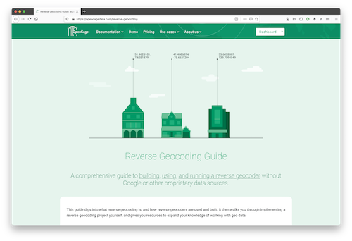
An example of that type of educational work is OpenCage’s recently published Reverse Geocoding Guide, which details the technical challenges of ongoing operation of a reverse geocoding service, while also documenting the advantages of using open data as the underlying data foundation for such a service.

OpenCage offers open source SDKs for accessing their geocoding API for over 30 different programming languages.

In addition to being corporate members of the OSMF, OpenCage are proud members of the UK (the business was started in the UK) and German (the business is currently based in Germany) local chapters, co-sponsor and contribute to the open source development of Nominatim (the primary OpenStreetMap geocoding software), and regularly sponsor OpenStreetMap events.

GEOMOB logo

OpenCage also encourages geoinnovation by running Geomob, a regular series of in-person and online events with the goal of promoting geoinnovation in any and all forms – whether for “fun or profit”, as the event tagline says. Now in its thirteenth year, Geomob has become an established feature of the European geo event landscape, and regularly features projects using OpenStreetMap.

Early in 2020 the Geomob podcast was launched. The weekly conversations provide a chance to reflect on geo industry trends, discuss interesting new geo technology, and interview Geomob speakers. Podcast guests have included many members of the OpenStreetMap community, including Allan Mustard (chairperson of the OSMF Board), Tyler Radford (executive director of the Humanitarian OpenStreetMap team), Sarah Hoffmann (maintainer of the geocoding tool Nominatim, which powers search on osm.org), several founders of businesses building on top of OpenStreetMap, and many more.


What is OpenStreetMap?

OpenStreetMap was founded in 2004 and is a international project to create a free map of the world. To do so, we, thousands of volunteers, collect data about roads, railways, rivers, forests, buildings and a lot more worldwide. Our map data can be downloaded for free by everyone and used for any purpose – including commercial usage. It is possible to produce your own maps which highlight certain features, to calculate routes etc. OpenStreetMap is increasingly used when one needs maps which can be very quickly, or easily, updated.

What is the OpenStreetMapFoundation?

The OpenStreetMap Foundation is a not-for-profit organisation, formed to support the OpenStreetMap Project. It is dedicated to encouraging the growth, development and distribution of free geospatial data for anyone to use and share. The OpenStreetMap Foundation owns and maintains the infrastructure of the OpenStreetMap project, is financially supported by membership fees and donations, and organises the annual, international State of the Map conference. The OSMF supports the OpenStreetMap project through the work of our volunteer Working Groups. Please consider becoming a member of the Foundation.

OSMF and Cesium joint press release: OpenStreetMap, a map of buildings!

Note: Cesium is a silver level corporate member of the OpenStreetMap Foundation, entitling them to this joint press release. If your organisation would like to support the OSMF more, please considering joining the OSMF as a corporate member, or read about other ways to give back.

Despite our project having “Street” in the name, there are 4 times as many buildings in OpenStreetMap as roads!

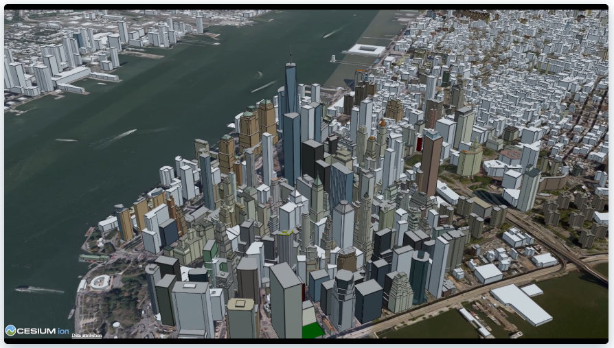
The newly released Cesium OSM Buildings from one of our newest corporate members Cesium is a global 3D building layer of more than 350 million 3D buildings derived entirely from OpenStreetMap. Cesium OSM Buildings is served as 3D Tiles, an open standard format for streaming 3D datasets, originally developed by Cesium.

Image © Cesium.

“OpenStreetMap has amazing 3D building data in cities around the world. It’s a testament to the skill and hard work of mappers in this community,” said Mikel Maron of the OpenStreetMap Foundation Board. “We appreciate Cesium’s support and advocacy of the project as a corporate member, and by adding OpenStreetMap data to their platform, they further advance our mission to ensure that OSM data is as widely used as possible.”

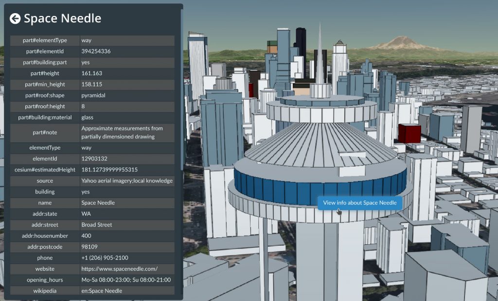
OpenStreetMap means rich metadata in most cities, like building name, address, and opening hours. Image © Cesium.

Cesium, which began as a project at an aerospace software company, has been maintaining its open-source virtual globe, CesiumJS, since 2011. CesiumJS recently surpassed 1 million downloads and its developer community has built thousands of applications in dozens of industries.

Cesium’s offering joins a vibrant community of projects which make use of building data from OSM. The OSM Buildings project is a free and open source web viewer for 3D buildings based on OSM. Open 3D rendering software based on OSM also exists for Blender, and in many other projects. OpenBuildingMap is a building focused window to OpenStreetMap, providing a filtered subset of OSM data with just the building data.

There are many tools for adding building data to OSM, from the popular building_tools and Kendzi3D plugins for JOSM, to StreetComplete, which helps our large contributing community survey building details. You can also read how buildings are mapped (“tagged”) in OSM. Our annual conference (State of the Map 2020), had a presentation on “Buildings are the new streets”.

OpenStreetMap – more than buildings
OpenStreetMap is a international project to create a free map of the world. To do so, we, thousands of volunteers, collect data about roads, railways, rivers, forests, playgrounds,
benches, fire hydrants and a lot more worldwide. Our map data can be downloaded for free by everyone and used for any purpose – including commercial usage. It is possible to produce your own maps which highlight certain features, to calculate routes etc. OpenStreetMap is increasingly used when one needs maps which can be very quickly, or easily, updated.

Providing data to OpenStreetMap – a new guide for data owners

As more and more maps are built on OpenStreetMap data, OSM is becoming the most compelling way for public organisations and other data owners to get their information out to the greatest number of people.

Two local councils in the UK, Oxfordshire County Council and Buckinghamshire Council, were recently funded by the Open Data Institute to investigate using and contributing to crowdsourced open map data – like OSM.

As part of this, I worked with the two councils to draw up a straightforward how-to guide for other organisations that want to contribute their data to OSM. The guide covers all the prerequisites – working with the community, compatible licensing, and ongoing maintenance – as well as explaining the different approaches for integrating data, and discussing which approach will be most suitable in each context. It covers the issues most frequently raised by data owners over the lifetime of OSM so far, and shows where to find more help if you need it.

I hope it will serve as a useful reference for the many organisations who express an interest in working with OpenStreetMap, and encourage more successful schemes in the future. Many thanks to the ODI and both councils for their support!

Richard Fairhurst

A new record for daily mappers and new users!

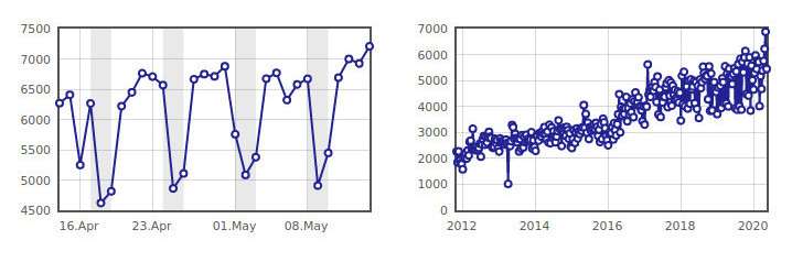
Number of daily mappers from mid-April to mid-May 2020 (left) and in recent years (right).
OpenStreetMap statistics on osmstats.neis-one.org © Pascal Neis. Screenshot supplied by Tobias Knerr. Map data © OpenStreetMap contributors.

OpenStreetMap has been breaking records in May – the record for the most daily mappers, the most newly registered mappers in a day, and the most newly active mappers have been broken numerous times. 

On May 12, a new record for daily mappers was set with 6,999, and then two days later, the record was beaten again with 7,209 mappers. There have also been records set for newly registered mappers, with 6,259 on May 14 as well as newly active mappers, 1,019 on the same day. You can see more trends from the OSM Stats site: http://osmstats.neis-one.org/?item=members

We were wondering if any of these numbers might be due to unusual activity of (e.g.) mappers who were normally mostly mapping during weekends and due to Covid-19 lockdown they now map during the week or due to increased organised editing in particular countries. For this reason, we contacted Pascal Neis and asked him whether he could provide some insight. Pascal was helpful, quickly researched the matter and provided his insights below (thanks!).

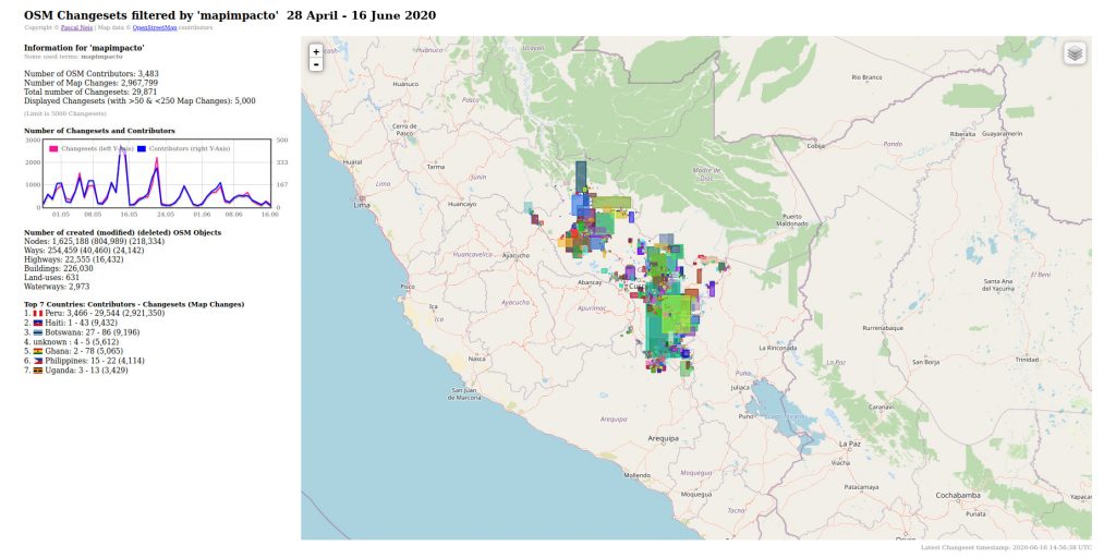
According to Pascal, the mentioned week in May had a high activity of members contributing in Peru, Botswana, Central African Republic and other countries. In particular, there was a high amount of newly registered members who started contributing to the Cusco region in Peru. It is also noticeable that the new mappers contributed mostly on weekdays.

OpenStreetMap changesets filtered by #mapimpacto. Data: 28 April – 16 June 2020.
OSM statistics on osmstats.neis-one.org © Pascal Neis.  Map data © OpenStreetMap contributors.

Pascal also took a close look at relevant hashtags and found some useful information: In Peru (not all, but) a significant amount of contributors utilized the #mapimpacto hashtag. Global Active Learning (GAL) School Peru, which received a 2020 HOT microgrant, co-ordinated HOT tasks there. In Botswana several mappers used the #COVBots hashtag. Besides this, we found that in India there was an effort by Educate Girls.

Going back to the newly registered accounts, this growth has been happening for some time — OSM has been growing for years, with about 1.5 million total contributors and more than 6.5 million registered users as of May 30. You can see detailed stats over time here.

It’s great to see new mappers joining our community. If you haven’t mapped in a while, why not take a look at your neighborhood, somewhere you’re familiar with, or somewhere new. You can see some options and learn more at https://wiki.openstreetmap.org. Also have a look at our good practice guide. And if you want to learn more about mapping with OpenStreetMap as an organization, check out the Welcome Mat at https://welcome.openstreetmap.org and remember to add any organised activities on the OSM wiki, according to the OSM organised editing guidelines.

Happy mapping!

Andrew and other CWG members, with input from Pascal Neis


Do you want to translate this and other blogposts in another language..? Please send an email to communication@osmfoundation.org with subject: Helping with translations in [language]

The OpenStreetMap Foundation is a not-for-profit organisation, formed to support the OpenStreetMap Project. It is dedicated to encouraging the growth, development and distribution of free geospatial data for anyone to use and share. The OpenStreetMap Foundation owns and maintains the infrastructure of the OpenStreetMap project, is financially supported by membership fees and donations, and organises the annual, international State of the Map conference. It has no full-time employees and it is supporting the OpenStreetMap project through the work of our volunteer Working Groups. Please consider becoming a member of the Foundation.

OpenStreetMap was founded in 2004 and is a international project to create a free map of the world. To do so, we, thousands of volunteers, collect data about roads, railways, rivers, forests, buildings and a lot more worldwide. Our map data can be downloaded for free by everyone and used for any purpose – including commercial usage. It is possible to produce your own maps which highlight certain features, to calculate routes etc. OpenStreetMap is increasingly used when one needs maps which can be very quickly, or easily, updated.

OSMF and GraphHopper joint press release: GraphHopper Routing Engine 1.0 Released

Note: The OpenStreetMap Foundation and GraphHopper publish this joint press release due to the Gold Corporate Membership of GraphHopper GmbH. If you want to be an OSMF Corporate Member too, you can join at https://join.osmfoundation.org/corporate-membership/

On 25th May the release of version 1.0 for the open source GraphHopper routing engine was announced. The first version 0.1 of the routing engine was released in 2013 and since then it has grown into a mature solution that is integrated on openstreetmap.org since late 2014 and is now used by thousands of companies around the world.

The new release contains a fast alternative routes feature, as well as a new customizable routing that allows people to modify the routing behaviour even without programming knowledge.

New feature of GraphHopper Routing Engine: Fast Alternative Routes
Customizable routing: Here the bike mode is forced to prefer official bike routes even though this means a big detour. Another use case would be a cargo bike where additional properties like road width are taken into account.


For a demo and more details about the new features you can read the full announcement at graphhopper.com

One key player in the GraphHopper community is the GraphHopper GmbH. The mission of the GraphHopper GmbH is to build the routing software stack of the future, with as many open source software as possible and also utilizing open data, like OpenStreetMap. The GraphHopper GmbH supports the OpenStreetMap project with sponsoring the routing service for openstreetmap.org, with using and improving the data as well as spreading the word. Since 2018 the GraphHopper GmbH is also a Gold Corporate Member of the OSMF.

What is GraphHopper
The GraphHopper Routing Engine is an open source software project started in 2012. The GraphHopper GmbH is a company founded in 2016 in Germany to support the development for its open source projects like the GraphHopper Routing Engine and jsprit. 

GraphHopper routing is integrated on www.openstreetmap.org, together with OSRM routing.

What is OpenStreetMap
OpenStreetMap was founded in 2004 and is a international project to create a free map of the world. To do so, we, thousands of volunteers, collect data about roads, railways, rivers, forests, buildings and a lot more worldwide. Our map data can be downloaded for free by everyone and used for any purpose – including commercial usage. It is possible to produce your own maps which highlight certain features, to calculate routes etc. OpenStreetMap is increasingly used when one needs maps which can be very quickly, or easily, updated.

What is the OpenStreetMap Foundation
The OpenStreetMap Foundation is a not-for-profit organisation, formed to support the OpenStreetMap Project. It is dedicated to encouraging the growth, development and distribution of free geospatial data for anyone to use and share. The OpenStreetMap Foundation owns and maintains the infrastructure of the OpenStreetMap project, is financially supported by membership fees and donations, and organises the annual, international State of the Map conference. It has no full-time employees and it is supporting the OpenStreetMap project through the work of our volunteer Working Groups. Please consider becoming a member of the Foundation.

OpenStreetMap and International Women’s Day

OSM logo surrounded by sketches of women's heads in different colours. Magnifying glass of logo has superimposed the sketch of two women high-fiving each other.
Sketches of women created at “Redefining women” iconathon, public domain, modified by D.Kazazi. OSM logo by Ken Vermette, CC-BY-SA 3.0 & trademarks apply.


Today we celebrate International Women’s Day, and while it would be nice to have no need for this day, we would like to take the opportunity to acknowledge the contributions of women OSMers.


Thank you for any contribution to the project – be it map data, code, organising mapathons, advocacy or other.

We do not know exactly how many women globally contribute to the OpenStreetMap project via mapping or other ways, however, it is known that the percentage of women in the OSM community – as in many tech adjacent communities – is low. The reason we do not know is because we do not ask for personal information such as name, gender or age when signing for an account on OpenStreetMap.org. Mappers can freely choose, and change, their username, and it is not mandatory that they respond to surveys, or map in a certain way. 

All this doesn’t make the collection of demographic data easy, and figures mentioning percentages should be taken with a big grain of salt. Collecting data on why people aren’t joining us is even more difficult as absent people can’t answer questions. While it has been impossible, so far, to get a clear picture on why some people contribute more or less than others, hypotheses have been formulated throughout the years – the lower percentage might reflect aspects of societies such as that many women have less free time than men. We should also note that the percentage of women OSM contributors varies geographically. The majority of attendees at Albanian community events, for example are women. We also seem to see more women participating when there is a clear goal – for example in humanitarian mapping campaigns we often have an almost equal gender balance.

The under-representation of women has been often highlighted on community channels, as well as by initiatives like Geochicas. They raise an important message, and we are also thankful for the work of local groups that are raising awareness.

We -do- know that the reasons that bring people of any gender, origin or age to our project seem to be similar among contributors: it’s fun to make the map data a bit better and it’s rewarding when someone finds your work useful. 

Renaming Belgium’s biggest tunnel
Initiatives of individuals have effect, both in the representation of women as well as on OpenStreetMap. So, we would like to take this opportunity to share some news from the Belgian community: the longest tunnel in the country, which currently carries the name of Leopold II, will be renamed after a woman, who has not been chosen yet. What does that have to do with OSM you may ask (other that the change will be reflected on our map data as soon as one of eager and active contributors can update it). The name change came about after officials became aware of equalstreetnames – a project by the Belgian OSM community and the Feminist Collective Names Maybe Maybe, which colours streets differently on an OSM-based map, depending on whether the streets are named after a man or a woman. You can read more about the tunnel renaming here.

OSMF board’s answer to recent press enquiry 
The OSM Foundation board and the OSM Communication Working Group have recently been contacted by a Reuters reporter, enquiring about why the number of women in OSM is low and what is OSM doing to address the gender imbalance and encourage more women to contribute. You can read the full answer here. Excerpts follow:

“We would like to highlight that anyone can contribute to OpenStreetMap, irrespective of their gender/nationality/religion and other factors (which we do not ask). Having said that, yes – there are actions both from the OpenStreetMap Foundation, as well as from community members, to increase the participation of women, and all underrepresented groups. Note that the OpenStreetMap Foundation has a relatively minor role in the OpenStreetMap project. Core infrastructure is run by volunteers, but even our map style and our website are built by independent volunteers. Most things that happen in the OpenStreetMap environment are run by the community.”

“The OpenStreetMap Foundation is interested in increasing the diversity in general and to attract marginalized groups of people and people outside the gender binary, not just women.”

OpenStreetMap Foundation and community efforts
Efforts by the OpenStreetMap Foundation and the OSM community mentioned in the press answer include:

Increasing diversity

  • The OSM Foundation has recently adopted a Diversity Statement which affirms support for expanding our diversity (in all its forms) in OSM.
  • The OpenStreetMap Foundation has also recently initiated a Diversity and Inclusion Special Committee. Its first task is to assist the Foundation (and hopefully the wider OpenStreetMap project & community) to identify imbalances in the community. To do so, it will gather and assess existing research, and collect any additional necessary data. It will then look at the causes, both internal and external, of imbalances, recommend actions to address them, and in due time evaluate their impact.

Mapping in support of women and girls

  • The community has created and maintains a page dedicated to mapping in support of women and girls. You can find it at https://wiki.openstreetmap.org/wiki/Tagging_in_Support_of_Women_and_Girls and it lists some points of interest that are related to women’s health, safety or life that can be mapped. Lit roads, gynaecologists, toilets for females and vending machines that dispense feminine hygiene products are a few examples of things that can be mapped.

We would like to emphasize that OpenStreetMap is based on mapping freedom and anyone can map almost any object with geographical qualities that is verifiable. So, if someone is interested in a feature that has not been mapped yet, they are free to create their own tags and add it to the database (it might be a good idea to discuss the created tags on the tagging mailing list to get feedback for potentially better tag options).

Specific communication channels

  • OSM is large, and made up of many smaller (sub-)communities. Many groups have been formed for people interested in this topic, which helps encourage members of that marginalized group participate in OSM. Geochicas is one example of this. Other examples are the communities formed around the Telegram channels RainbOSM and Geoladies (there is some overlap of participants).

Ensuring safe and welcome participation at OSM events

  • The OSM Foundation organises the annual, international State of the Map (SotM) conference, which has rules ensuring that a wide range of participants feels safe and welcome.
  • There are local OpenStreetMap events run by community members with rules having the same aim.

Granting scholarships to the annual conference

  • The OSM Foundation has a scholarship program providing support to community members who cannot afford to travel to the international State of the Map conference. Gender is a core consideration in the selection process.

Electing women to the OSM Foundation board

  • Before December 2019, both the chairperson and the secretary of our Foundation were women. Board members are voted by the OSM Foundation membership.

Please note that OSM Foundation members constitute a small part of the community – you don’t need to be an OSMF member in order to participate in the OpenStreetMap project, you just need to create an account at www.openstreetmap.org. Having said that, we would like to see the OSMF membership becoming more diverse so please consider joining the Foundation. We are also trying to make it easier to join.

Raising awareness

  • Participation of women in OSM, and diversity in general, is a subject frequently discussed in community channels, has been highlighted in talks by community members in State of the Map conferences and has led to actions by the OSM Foundation.

Reach out and support

  • Various local groups reach out to women and engage them in introductory OSM workshop, offering support afterwards.

Recognising the contribution of specific women OSMers

  • For the past several years, the OSM community has nominated and selected individuals, groups and projects which have helped the project. One of the OpenStreetMap Awards is for “Expanding the Community”, which recognises growing and diversifying the OSM community.
  • Nominations for the 2020 OSM Awards are currently open. If you know of anyone whose contributions you want recognised, please nominate them!

Please note that the list above is incomplete, as there are many efforts by local communities. We invite you to share the contributions of your local group in the comments.

New article about female participation in OSM 
You can read Reuters’ article, which focuses on female participation in OSM and is based on conversations with OSMers such as Geochicas and the OSM Foundation Board at “Visible women’: Feminist mappers bridge data gap in urban design”.

We would like again to thank anyone who identifies as a woman for their contributions and would like to highlight that mappers don’t require permission, moderation, approval or votes by the existing majority in order to add new things, or to start mapping new features. Even small minorities can map what’s important to them. This openness, and flexibility, allows OSM to be welcoming to new, and unforeseen, types of contributions.


Are you an OSMer who identifies as a woman? Share with us in the comments what you are passionate about. If you would like to answer anonymously, feel free to send your answer to communication@osmfoundation.org and we will post it without your (user)name.

International Men’s day is on 19th of November.
International Nonbinary Day is on 14th of July.

Do you want to translate this and other blogposts in your language..? Please send us an email to communication@osmfoundation.org with subject: Helping with translations in [your language]

The OpenStreetMap Foundation is a not-for-profit organisation, formed to support the OpenStreetMap Project. It is dedicated to encouraging the growth, development and distribution of free geospatial data for anyone to use and share. The OpenStreetMap Foundation owns and maintains the infrastructure of the OpenStreetMap project, is financially supported by membership fees and donations, and organises the annual, international State of the Map conference. It has no full-time employees and it is supporting the OpenStreetMap project through the work of our volunteer Working Groups. Please consider becoming a member of the Foundation.

OpenStreetMap was founded in 2004 and is a international project to create a free map of the world. To do so, we, thousands of volunteers, collect data about roads, railways, rivers, forests, buildings and a lot more worldwide. Our map data can be downloaded for free by everyone and used for any purpose – including commercial usage. It is possible to produce your own maps which highlight certain features, to calculate routes etc. OpenStreetMap is increasingly used when one needs maps which can be very quickly, or easily, updated.