Note: Cesium is a silver level corporate member of the OpenStreetMap Foundation, entitling them to this joint press release. If your organisation would like to support the OSMF more, please considering joining the OSMF as a corporate member, or read about other ways to give back.
Despite our project having “Street” in the name, there are 4 times as many buildings in OpenStreetMap as roads!
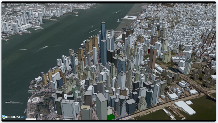
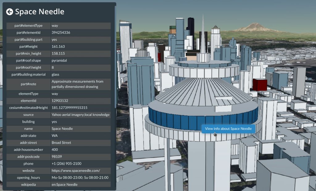
The newly released Cesium OSM Buildings from one of our newest corporate members Cesium is a global 3D building layer of more than 350 million 3D buildings derived entirely from OpenStreetMap. Cesium OSM Buildings is served as 3D Tiles, an open standard format for streaming 3D datasets, originally developed by Cesium.
“OpenStreetMap has amazing 3D building data in cities around the world. It’s a testament to the skill and hard work of mappers in this community,” said Mikel Maron of the OpenStreetMap Foundation Board. “We appreciate Cesium’s support and advocacy of the project as a corporate member, and by adding OpenStreetMap data to their platform, they further advance our mission to ensure that OSM data is as widely used as possible.”
Cesium, which began as a project at an aerospace software company, has been maintaining its open-source virtual globe, CesiumJS, since 2011. CesiumJS recently surpassed 1 million downloads and its developer community has built thousands of applications in dozens of industries.
Cesium’s offering joins a vibrant community of projects which make use of building data from OSM. The OSM Buildings project is a free and open source web viewer for 3D buildings based on OSM. Open 3D rendering software based on OSM also exists for Blender, and in many other projects. OpenBuildingMap is a building focused window to OpenStreetMap, providing a filtered subset of OSM data with just the building data.
There are many tools for adding building data to OSM, from the popular building_tools and Kendzi3D plugins for JOSM, to StreetComplete, which helps our large contributing community survey building details. You can also read how buildings are mapped (“tagged”) in OSM. Our annual conference (State of the Map 2020), had a presentation on “Buildings are the new streets”.
OpenStreetMap – more than buildings
OpenStreetMap is a international project to create a free map of the world. To do so, we, thousands of volunteers, collect data about roads, railways, rivers, forests, playgrounds, benches, fire hydrants and a lot more worldwide. Our map data can be downloaded for free by everyone and used for any purpose – including commercial usage. It is possible to produce your own maps which highlight certain features, to calculate routes etc. OpenStreetMap is increasingly used when one needs maps which can be very quickly, or easily, updated.
This post is also available in: French Galician Japanese Spanish Polish
Pingback: weeklyOSM 526 | weekly – semanario – hebdo – 週刊 – týdeník – Wochennotiz – 주간
Uuuuuh, no aknowledgement of “Cesium OSM Buildings” and “OSM Buildings” having the same name?
Pingback: weeklyOSM 527 | weekly – semanario – hebdo – 週刊 – týdeník – Wochennotiz – 주간
May be “OSM Buildings” (which exists as a community project since 2012, but which was not registered either as a trademark or at the foundation) could be simply qualified better:
“Community OSM Buildings” ? or something like that. Once the prefered possible choices are made, then submit it for licensing and protection to the OSMF (this will require a designated registrant name, it may be sponsored by some local OSM chapter).
For now the name “OSM Buildings” was used informally (and without prior licencing/authorization by the OSMF). So I do accept the decision made by the OSMF (which should still have been opened before the fact by an open discussion before the final approval vote, but I don’t see anything bad with “Cesium OSM Buildings” as long as it is not abbreviated: the full name is required and should be used by Cesium in all its communications)
Anyway the choice made by Cesium to use “OSM” in the name of its product is probably bad, and Cesium could have also been more inventive for its product, with something like “Cesium Buildings Viewer”, “Cesium Buildings Navigator”. Its product may as well use other additional data sources than OSM or could use specific features (e.g. for indoor navigation, architecture and city planning, environmental projects, city renewal projects…) or could have interfaces for integrating proprietary data for their customer bases and their own business projects.
Most probably they will change in the future to have a better distinctive name that cover their goals. It is still independent of the Gold sponsor membership of Cesium.
I don’t see something serious here: names can change from both parties, it’s up to them to decide. But the community OSM Buildings project made since 2012 should really work with the OSMF to register their own name and have it sponsored correctly, while also obeying to the OSMF rules and community rules for their use of the brands protected by the OSMF (for good reasons, so that it cannot be stolen by private interests and so that the community and local chapters won’t be harassed by some hostile financial claims by profitting investors: we need this protection of these brands, just like Wikimedia, Mozilla, and most opensource/open data/open knowledge also protect their brands; otherwise they would not be able to defend them).