Last weekend, the OSMF Board had our face-to-face (F2F) meeting in Amsterdam. I took a cheap flight on Friday and left early Monday morning to spend 2 full productive days in our meeting venue, to work together on stuff that hadn’t happened in our monthly Board meeetings. Preceding the event, we discussed if we should have an in person meeting at all, but we finally agreed to meet. This blog post should give you an overview of the weekend: how it was organized, what happened, what topics we discussed, how I felt about it, and the more general outcome of the event. However, I’ll leave out most of the detailed results as we’re still working on and will be published soon, I don’t want to preempt that.
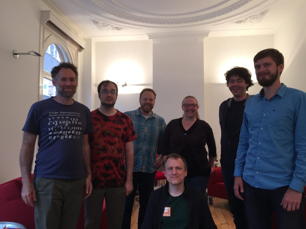
The OSMF Board, still smiling after a hard day’s work
Preparation
Of course an event like this has to be prepared in advance. This includes accommodation, meals and of course the topics that we wanted to talk about. Martijn was a great help for the first two points as he lived in Amsterdam until 2011. He found a great venue for us that also featured two bedrooms for accommodations. I was one of the lucky ones to get a room, so no extra work for me to find a place. The other Board members mostly took private housing offers nearby the venue; Frederik also stayed in one of the venue’s rooms. As for the meals, Martijn organized breakfast, lunch and dinner. While breakfast and lunch were arranged in a way to not waste any time and to get back to work quickly, we took a bit more time for our dinner and even met with the local OSM community on Saturday.
For planning of topics and arranging the event we worked with Allen Gunn, an experienced facilitator who works frequently with open source communities. For those who don’t know about facilitation, as I didn’t, it’s a person who helps to arrange events, leading sessions and trying to steer them to get things done. And in case of conflicts, responsible to settle things and move back to constructive work. As a first step, he wrote a mail to each of us asking questions on what we expected from the event, what topics we wanted to have on the agenda, what topics might lead to heated debates and things like that. Unfortunately all of that happened a bit late and we only got an agenda for our event on Friday morning, which at first not everyone was happy about. Sadly, Gunner couldn’t make it to the event himself, so we were on our own, guided by the agenda developed by him. I regret that a bit, as I was curious how facilitation would work, but on the other hand, we were able to work well on our own.
Agenda
As I said above, I don’t want to preempt the results of the meeting, but I guess it’s ok to talk a bit about our agenda. We had a strict schedule, starting at 9:00 and closing at 17:00 on Saturday and Sunday. For example topics, we spent 90 minutes on committing to greater transparency, and about 45 minutes on on boarding the admin assistant. We also had less specific topics like “Comparing Perspective on ‘Leadership'” and “Building Organizational Vitality”.
And even though each topic on the agenda had some extra text explaining it, I was not always sure what to expect. I guess that’s also why other Board members noted in advance that they were not entirely happy with the agenda as is. But this was not a problem after all, as we could easily change the agenda where needed, and take more or less time for one or another topic. I’m not sure if we would have handled this as flexibly if we had in person facilitation.
Expectations
I was uncertain what to expect from this event, and especially since it was expensive for some Board members flying from overseas. I was hesitant if we needed to meet in person at all. Though, several Board members with experience of F2F meetings were in favor, and as I had never attended an F2F meeting, I couldn’t really judge, so I abstained from that decision. Asked by Gunner, I explained that, and emphasize that I wanted to talk about transparency. I did hope that we could get on common ground there, but I also thought this would be a heated debate, with most other Board members holding a different opinions. I should probably state this now: I was utterly wrong, see below.
Further I was quite nervous and anxious that I would be able to follow the conversations in English and understand everything being said. However, this went pretty well. Even though my English is for sure not super expressive, I was able to contribute to each conversation, even though sometimes a bit haltering 😉 I followed most of what was said, and I could even mostly follow Paul, who was the hardest to understand. (As Paul put it, that’s because Kate and Mikel speak simple American English but he speaks the real thing, Canadian English. :))
Interestingly, another common theme shared with Gunner by Board members was a desire to get things done. They expressed that we didn’t get many things completed yet this year, but at the same time they thought that we had worked well together. So they focused their expectations on this: get things going, do some actual work or at least scope what’s possible, and what was beyond our reach. Also remember, much of OSMF work is actually done by working groups, and we don’t want to command but rather support them.
Functioning
As noted above, our facilitator Gunner could not make the event, so we had to manage it ourselves. We had the agenda he compiled for us and we used that as our base for discussions. Still you need someone to channel an agenda and in the end, Mikel stepped up to help. He put a considerable amount of time to discuss the event up front with Gunner, and facilitated every single session. As he also wanted to participate himself, with his input and opinion, he had to do both, IMHO a quite difficult task but he did a great job with that for sure.
We started (and closed) quite a few sessions with a round of short statements from each Board member. Everyone would have one minute to explain what they expect from a topic, or how they feel about something. It gave us a quick overview where each participant stood, and thought about the topic. I found this very interesting, I didn’t expect that we shared so many many opinions. Many sessions involved a huge amount of post-its :-). For example, in the transparency session, we glued 4 big sheets on the window with headers “OSMF internal”, “WG internal”, “public readable”, “public writable”. Everyone had a stack of post-its, wrote a topic on each and stuck it to that sheet where it is currently handled (e.g. “meeting minutes” would be “public readable” or “individual donation details” would be “OSMF internal”). Then, we clustered the notes, as we individually had many ideas in common with each other. And after that we did a round-robin, where we each selected an item,and suggested to move it to someplace else. We discussed, and if approved, it got a sticker on it, so we could later record that it moved (e.g. someone takes “board meetings” from “OSMF internal”, moves it to “public readable” and puts a sticker on it) . There were some controversial topics and there were some surprisingly uncontroversial ones. By the end, many things had moved, and I’m especially happy with the outcome of that session.
Most sessions went this way, with a bit of variation. For example, for the session about a “diverse and global community” we had 3 big sheets “Working”, “What we want to change” and “Disagree”. We again collected ideas on post-its, stuck on the first two sheets and clustered them. Topics we didn’t agree on moved to the third column. Then, we voted on the highest priority topics. Everyone got three stickers and was allowed to select whatever they most valued. At the end, we had a few priority topics to work on further.
I still don’t know what to think about this way of working. I’ve never done something like this before. I didn’t think it was the best way of handling every topic, but I have no better ideas on how to deal with something like this. I do have to note, we got things done this way.
On Sunday, we worked a bit differently. We split up into smaller groups to work intensively on topics. One topic was corporate membership, where three of us collected member feedback, and built upon it. Simultaneously, we had a second session about an Open Source Policy which I attended. We got quite negative feedback from some of the community when we said we were evaluating GitHub for tracking our Board’s internal work, so we agreed to write an Open Source Policy as a guideline for software choices. This was one of the topics I’ve been keen on, too. We used an etherpad to collect a list of points, and developed an outline. I’m quite happy with the results and I hope we get this written out soon to share with you.
Outcome & Future
So what is the outcome of all this? It helped me to get to know the other Board members much better, and I hope and even expect that this will also help in the future. Don’t get me wrong, we have worked well together in the past, but now I know better how each of us think about different topics and I have a bit more idea of personal make up of the other Board members, like when something is a joke and when it’s not.
And I especially hope that we’ll be more productive after this meeting. We can let a Board member work on topics important to them, and have a better idea of the scope of our work. I want to see the things we decided become a reality. We have a large number of action items to work on for the next meetings, and I hope these will be finished in the near future.
Even though I’m enthusiastic about the F2F meeting and its results, it is still another question if it’s worth doing again. We spent a good amount of money to meet, and one might argue that we could have achieved the same result with an online meeting, or by discussing everything by email. I’m still not sure about what to think about that. We are going to assess the effectiveness later, when we can see if and how many of our decisions are actually put into action. I did talk to other Board members about this at dinner, and there are at least two good arguments I heard that might make the F2F meeting worth it. First, dedicating so much time to an online meeting as we did at the F2F is almost impossible. When at home I can’t tell my wife and kids to not enter the room, and I wouldn’t be able to take 8 hours off to talk and discuss. The F2F forces you to do so. You meet with six other people, and cognizant of the effort and cost to get there, you’re focused to make the best result. Second, if we do get a corporate membership plan that everyone is happy with, and just get one new gold member, our F2F meeting would be paid for. Still, I’m just repeating other’s arguments; ask me again in two months or so :).