OpenStreetMap events in 2015

The OpenStreetMap Foundation has been organising the annual State of the Map (SotM) conference since 2007. These events have proved popular with our community and beyond, and have grown from a few dozen attendees to a high of 300 attendees at SotM 2013. This year we had two good bids to host SotM 2015, but issues beyond our control caused concerns about whether we could make this into a success. The SotM working group, with the support of the OSMF board, has therefore agreed that there will be no OSM Foundation organised conference this year.

As the OpenStreetMap community has grown over the last 10 years, so has the conference scene. Even without OSMF organising a conference this year, there will still be a number of OSM-centered conferences, including SotM US at the UN’s New York headquarters in June, and SotM-Scotland in October. There are also many webinars, mapping parties, hack events and socials planned for 2015.

UN General Assembly hall

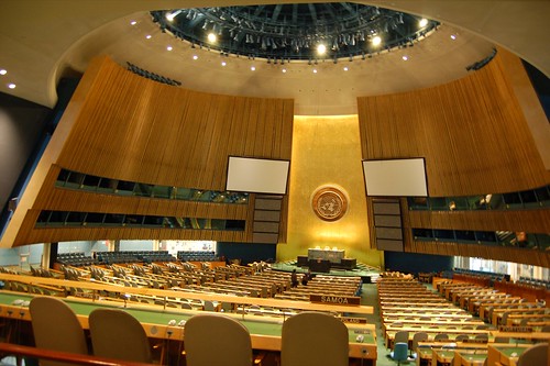
SotM-US will be held at the UN headquarters in New York, 6-8 June 2015
(image CC-BY 2.0 Dan McKay)

The StateoftheMap Organizing Committee has taken on a number of new members to support our efforts in 2015, 2016 and beyond. We are currently drafting a proposal on the future of SotM in which we are looking at the role of SotM within the project and how the OSMF SotM relates to the various regional events. We already have some views but we encourage you to share yours in the comments below.

Preparations for State of the Map 2016 will be starting soon and we encourage local groups who may be interested in hosting SotM in their home country to contact us early.

Blog post by the StateoftheMap Organizing Committee

OpenStreetMap Foundation Face2Face Meeting: Day 1

Today was the first Face to Face(F2F) meeting I’ve participated in as a OSMF board member. Though I had met the rest of the board, this was the first time I’ve been together with them since my own election. In today’s day of video conference, IRC, Skype, Etherpad and many other forms of remote collaboration, it is still great and productive to be together. Allen Gunn (Gunner) of Aspiration Tech has been facilitating us. This is the first F2F in recent memory that has been facilitated, but I can’t compare it to the previous one. Having someone help us focus on outputs and avoiding getting stuck on topics however has been invaluable.

There were multiple key exercises today that helped us both realize where we agree/disagree as well as prioritizing efforts for the board over the next year. We started off the day with an exercise where a line is set-out in a room and participants stand on a point of their choosing in response to a stated proposition – one end is “strongly agree” the other end is “strongly disagree”. What became clear is really there is not the extreme differences we may have thought we had. I think if the membership of the foundation were to ever meet and do this we’d discover the same thing.

Photo Credit: Paul Normal

Photo Credit: Paul Norman

The other exercises were on specific topics. We used similar techniques to list, prioritize and evaluate the outputs. The topics we worked on were: what we see as our core values, what we want to accomplish over the next year, what is/is not working in OSM, and what is the responsibility of the OSMF board vs the OSMF Foundation as a whole. We’ll be sharing this information out with the community in a more robust feedback this week. First we need to finish transcribing our Post-it Notes. I’m excited about our initial results so far and I’m feeling energized and excited to continue.

Routing on OpenStreetMap.org

Good news for OpenStreetMap: the main website now has A-to-B routing (directions) built in to the homepage! This will be huge for the OSM project. Kudos to Richard Fairhurst and everyone who helped get this up and running.

osm-routing

You might be thinking, “Why would this be huge? Isn’t it just a feature that other map websites have had for years now?” Well, the first thing to note is that the philosophy of OpenStreetMap is not to offer a one-stop-shop on our main website, but to create truly open data to empower others to do great things with it. So there has already been fantastic OSM-based travel routing for many years, on excellent websites such as OSRM, Mapquest, Graphhopper, Cyclestreets, Komoot, cycle.travel… the list goes on and on.

But all of those things are on other websites and apps, so people don’t always realise that OpenStreetMap has this power. What this latest development has done is really neat: the OSM website offers directions which are actually provided by third-party systems, but they are included in the main site via some crafty JavaScript coding. So as well as being really handy in itself to have directions available, it helps “first glancers” to see all the things they can do with OSM.

But that’s not what makes it huge.

What makes it huge is the difference it will make to OpenStreetMap’s data by creating a virtuous feedback loop. One of the main reasons we show a “slippy map” on the OpenStreetMap homepage is because people can look at it, see a bridge that needs naming or a building to add, click “Edit” and fix it straight away. That feedback loop is what allowed OpenStreetMap to build up what is now the most complete map of many regions around the world.

But we have a saying: “what gets rendered, gets mapped” – meaning that often you don’t notice a bit of data that needs tweaking unless it actually shows up on the map image. Lots of things aren’t shown on our default rendering, so the feedback loop offers less incentive for people to get them correct. And that goes doubly for things that you never “see” on the map – subtle things like “no left turn” at a particular junction, or “busses only” access on a tiny bit of road, or tricky data issues like when a footpath doesn’t quite join a road that it should join on to. Now that people can see a recommended route directly on the OSM homepage, they have an incentive to quickly pop in and fix little issues like that. The end effect will be OSM’s data going up one more level in terms of its quality for routing. This will empower everyone to do great things with geographic data and getting from A to B.

So find yourself some directions today!


Blog post by Dan Stowell

OpenStreetMap Local Chapters – Welcome Iceland

The OpenStreetMap community has a wide array of different local groups forming in different corners of the globe. It’s time to formalise the idea of “local chapters”. We now have a definition and a process, and we have our first official OpenStreetMap Foundation Local Chapter!

openstreetmap-iceland-website

OpenStreetMap á Íslandi” is a subgroup of Hliðskjálf, an Icelandic society for open and free geographic information data. Well done to Jóhannes from Hliðskjálf who went through the process of getting this organisation set up as an OpenStreetMap Chapter.

Of course we have always had local OpenStreetMap groups forming all around the world, small groups of collaborating mappers, but also groups on a bigger country scale. These organisations help to present OpenStreetMap in a particular language, and engage a community with consideration for local culture and customs.

The idea of local chapters has long been discussed, as a name for these groups. We’re borrowing this idea from the Wikimedia foundation. And now we are formally introducing local chapters as a way of establishing a relationship between regional OpenStreetMap organisations and the OpenStreetMap Foundation. This is a hugely important step in the development of the OSMF.

The actual definitions, requirements and processes have been laid out. Read these, and more information, on the Local Chapters page.

Four New Tile Servers

Have you noticed faster tiles lately? Browsing the map on openstreetmap.org should now be even more responsive. Three new servers, started providing tiles over the last 2 weeks, joining a server which started earlier in the year.

osm-cdn-2015-01

Map tiles are delivered to users based on their GeoDNS location. The OpenStreetMap tile content delivery network (CDN) now supports EDNS-client-subnet to improve locating the closest region tile cache.

OpenStreetMap tiles are free for everyone to use, but should be used with moderation. If you are a high traffic site you should look into switch2osm.org to find out how to use the data and keep the tiles available for everyone.

Thanks to generous donations and active local community members, the OpenStreetMap distributed tile delivery infrastructure continues to grow.

The OpenStreetMap Foundation seeks additional distributed tile servers. If you would like to donate a tile server and hosting, please see the Tile CDN requirements page on the wiki. You can also support OpenStreetMap by donating to the OpenStreetMap Foundation.

The OpenStreetMap Foundation is a not-for-profit organization, formed in the UK to support the OpenStreetMap Project. It is dedicated to encouraging the growth, development and distribution of free geospatial data and to providing geospatial data for anyone to use and share. The OpenStreetMap Foundation owns and maintains the infrastructure of the OpenStreetMap project.

Mapazonia

The Latin America OpenStreetMap community was created recently and we decided to organize collective projects on subjects that are common to many countries of our continent. Our first project is Mapazonia.

mapazonia
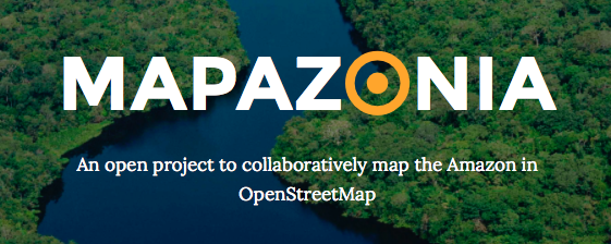
The Amazon rainforest includes territory belonging to nine different nations and there are a lot of environmental institutions and governments that need better geospatial data to do their work in that region. Furthermore it’s always good to have quality data in case of a natural disaster or other humanitarian issues. In Brazil there aren’t many editors in this northern region, so there are a lot of towns without any data and some roads to trace.

The Amazon is huge, it has 5 million and a half square kilometres. So initially we are defining some prioritary areas to map in Tasking Manager. There is already one activity in Brazil and another in Bolivia. The main aim is to improve the tracing of the rivers and the road coverage.

Soon we will have more areas in others countries. If you want, you can work in others areas of the Amazon. Put the hashtag #mapazonia in your changeset comments, so we can see your edits in this map.

Visit the site: http://mapazonia.org, follow the twitter account @mapazonia and enjoy mapping the Amazon!

Happy Christmas from OpenStreetMap

OpenStreetMappy Christmas Card

Happy Christmas from OpenStreetMap to all of our contributors.

This sentence doesn’t actually make sense when I think about it. It’s a familiar kind of sentence you might see on a company website, but OpenStreetMap is a project. A collaboration. A map, a database and a community. It’s not a company. I sometimes describe it as a “nebulous internet collective”. OpenStreetMap is all of our contributors. So when we say a Happy Christmas from OpenStreetMap, we are all wishing ourselves a Happy Christmas. Maybe it does make sense. I think I can speak for all OpenStreetMappers in wishing each other a Happy Christmas.

We’re all working together on this project to create an open licensed map of the world, and whether you’ve met other mappers or not, whether you’ve engaged in community discussions or not, you have added your contributions and slotted your piece into the jigsaw of this mighty collaborative endeavour. Please turn to the OpenStreetMapper on your left and wish them Happy Christmas! (Or seasons greetings, happy holidays, happy winter festival… whatever fits)

And a Happy Christmas to all those who are using OpenStreetMap. All those who have seen maps embedded on a website, downloaded maps to their mobile apps, or printed maps out on paper. We hope you enjoyed OpenStreetMap, and of course there’s an easy way to give us a Christmas present in return: Get involved!

New query feature

A couple of weeks ago we mentioned a brand new feature on the OpenStreetMap.org homepage. On the right hand side we have a new “?” button which lets you query the map.

  • On openstreetmap.org, zoom in somewhere
  • Click the “?” button to enter query mode
  • Click the map on something you are interested in
  • Hover over the results, and choose one to find out more

query_tool

When you query a spot on the map, this new tool will retrieve nearby points of interest from the OpenStreetMap database, and let you quickly drill down to all of the detailed tagging information we have in that database.

More than a map

This new tool helps highlight a crucial point about OpenStreetMap. It’s so much more than just a visual map. OpenStreetMap is a rich database of geo-located information, only some of which is visible on the “standard” view of the map. Other information is visible via different layers (such as cycle routes presented on the cycling layer) and all of the data can be viewed by enabling the “map data” layer (also on the layer picker panel) but this query tool offers a new window into the OpenStreetMap data, and a new way to discover all the details our contributors are adding to the database.

For developers this data opens up a world of possibilities. All the data is available to download for free.

State Of The Map – Thanks

Last week the OpenStreetMap community came together for their annual conference “State Of The Map”

We need to say a huge thank you to all the people involved in organising this year’s conference, including Henk Hoff, Gonzalo Gabriel Perez, Fernando Sanz, and Nicolás Alvarez. They battled various problems, and came out with a triumphant success!

A big thanks also to this year’s State Of The Map Sponsors:

sponsor logos

As it has been in previous years, the conference was wonderful meeting of OpenStreetMap friends, a showcase of diverse modes of map use/contribution, and a melting pot of ideas to take the project forwards. Another big thank you to all those who presented. We will be aiming to publish videos of the talks (always more easily said than done) [update Videos starting to appear here There are already some photos on the ‘sotm14’ flickr tag. The program on the SOTM 2014 wiki page links off to various wiki-editable session sub-pages. Please feel free to edit these pages to add links to slide-decks and other coverage.

Besides the general buzz and exciting talks, there were a couple of important extra things coming out of the conference:

OpenStreetMap Foundation Election Results

As has been the the norm in the past, we held the OpenStreetMap Foundation Annual General Meeting during the SOTM conference, and this included electing a new board. Frederik Ramm was re-elected, and we elected Kathleen Danielson and Paul Norman replacing Matt Amos and Simon Poole who were stepping down.

Congratulations to the new board, and thanks to all the candidates and organisers of this election. More election details on the wiki

New feature ‘?’

As has also been the norm at past conferences, OpenStreetMap developers have prepared a little something special as a new feature to be launched on the weekend of the conference. This year they’ve added a new ‘?’ button on the right hand side of the openstreetmap.org front page. Didn’t notice? Give it a try! More details coming soon.

New OpenStreetMap Latin America

Also during the conference there was a meeting of the brand new OpenStreetMap Latin America group. They have recently established themselves with a new ‘talk-latam’ mailing list and they are planning a “State Of The Map Latin America” conference, to join the set of local spin-off conferences held around the world.

This is fantastic news, and a great result to come out of our visit to Buenos Aires. We have aimed to organise the annual conference in a variety continents, to help spread OpenStreetMap enthusiasm to different corners of the globe. So this kind of group-forming and general boost is exactly what we are aiming for. But in fact the OpenStreetMap community of South America has always been quite impressive, so it’s only fair that the conference came there this year. And what a joy it was! Buenos Aires is a beautiful city, and the Argentinean OpenStreetMap contributors were wonderful hosts for State Of The Map 2014.