The “PD checkbox”

If you signtickbox-distorteded up for an OSM account after May 2010 you may have noticed a check box with the label

“in addition to the above agreement, I consider my contributions to be in the Public Domain”.

Many years ago when the discussion started on the new licence for OSM data, one of the larger issues was if we should not adopt a very liberal (as in free) stance and use something close to a public domain distribution instead of the share-alike provisions we had in the existing CC by-SA licence. In the end, as you know, last year we switched to a licence with strong share-alike provisions, the ODbL, We did however add the “PD checkbox” in an attempt to span the gap between the two camps.

Unluckily what ticking the box would actually imply was, and continues to be, rather unclear; interpretations range from participating in an informal survey to actually giving permission to use the data on PD (or similar) terms. On top of that, at least for some time, there was a design issue with the specific page that potentially led to new contributors selecting the option inadvertently. Not to mention that the explanatory text changed multiple times in different locations.

To make a long story short: it is a mess.

In June MapBox asked the board for a list of the users that had checked the “PD checkbox” on sign up or later, see board minutes 2013-06-20. After some discussion and feedback from the LWG WG minutes 2013-06-25 the board decided to publish overall numbers on the one hand to give an answer to a not unreasonable information request and further to try and lay this issue at least partly to rest:

Data per 19th September 2013

“PD check box selected” all active accounts: 37%

“PD check box selected” active accounts with at least one edit: 44%

As outlined above, the numbers can at best be taken as an indication of sentiment.

If it wasn’t clear from the discussion of the quirky history of the checkbox and the legal uncertainty that surrounds it: this does not imply that an extract could be made from OSM data that contains a substantial amount of “PD” data. Outside of the already mentioned issues, edits from accounts with this flag set are intermingled with edits of those that don’t have it set, and as the statement from the licence working group says: there is no guarantee that a user actually only contributed and continues to only contribute data from sources that are compatible with a PD distribution.

To conclude: while a significant minority of our contributors would prefer a less restrictive licence, and this will not be ignored in future discussions, we are currently obliged to operate within the spirit and letter of our current licence.

New Humanitarian Style

We’ve added a new map style option to the OpenStreetMap front page. Feast your eyes on the new “Humanitarian” style:

This style has been developed by the Humanitarian OpenStreetMap Team to support their work, highlighting features they are most interested in, as well as just providing a contrasting stylisation of the map. The developer Yohan Boniface explains:

“OpenStreetMap data is as rich and varied as the real world. And, just as when you look through a window you can’t take in the whole world, so it is with a map based on OSM data: you can’t show it all. This is why we decided to provide the view from another window, through our own map and cartography, focusing on the world as seen through HOT’s community.”

“You may have noted that the colour scheme is light and pastel. This is certainly an aesthetic choice offering a nice contrast with the “standard” OpenStreetMap style. Consistency in the colour is also key to the readability of a map. But there was another goal for this. Now maps are everywhere, whether it is online or printed. But a generic map like the one we are building is generally only part of the message: whether it is online or printed, maps are often used with some custom data on top of them. For example, markers can be added to an online map to show specific points of interest. But also, more simply, they can be printed in order to draw on top of them. This could be details of a trip, a vaccination campaign, or additional map data when mappers are surveying. In all those situations, the map should do its job, providing geo information, but also leaving visual space for the main message.”

Read more about the new style on the HOT blog.

You can access this new style along with our other featured tiles any time you’re browsing the front page map, by clicking the layer icon on the right hand side.

Weekly OSM Summary #77

August 26th, 2013 – September 9th, 2013
A summary of all the things happening in the OpenStreetMap world.

Authors: Pascal & Dennis – (thx @ “Wochennotiz”)
Foundation AGM and board election results

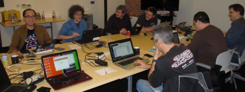
The State of the Map conference in Birmingham is winding down (although today there’s a very lively room full of fifty OpenStreetMap hackers in way number 32637693) We’ll bring you a summary of all the SotM excitement soon. But before that… some OpenStreetMap Foundation business.

On Saturday we held the Foundation Annual General Meeting.

State Of The Map

Simon Poole, chairman of the board, conducted proceedings and gave his summary of the past year’s foundation news, and then we held a vote.

Board election results:

As Frederik announced on the mailing list, Dermot McNally and Oliver Kühn were both re-elected to the board. Congratulations to them. And they are joined by Kate Chapman.

Kate Chapman said in her manifesto: “Generally I would like to see the OSMF assist OSM in becoming more diverse, I think my experience through the Humanitarian OpenStreetMap Team (H.O.T.) can help make that happen”.   Welcome to the board Kate!

The vote counts looked like this:

  • Kate Chapman 114
  • Dermot McNally 85
  • Oliver Kühn 57
  • Roland Olbricht 54
  • Kai Krueger 42
  • Gregory Marler 40
  • Marek Strassenburg-Kleciak 13

Thank you to all of the candidates for taking part in this process.

Articles of Association

We also voted on adoption of new Articles of Association, and 92% voted in favour, and so this is accepted.

On the issue of whether to allow corporate members to vote, opinions were a little more divided. The count was: For:75; Against:59; Abstain:14. This means a 58% yes vote, and the target of 75% has not been reached, so the amendment is not accepted.

You can read a little more about the points discussed at the AGM, in the draft meeting minutes.

Weekly OSM Summary #76

August 12th, 2013 – August 26th, 2013
A summary of all the things happening in the OpenStreetMap world.

Authors: Pascal & Dennis – (thx @ “Wochennotiz”)
Last chance to vote by email

Today is your last chance to vote by email for this year’s foundation board elections. If you are a member of the OpenStreetMap Foundation, and you are not planning to vote at the annual general meeting in Birmingham this Saturday, then please read the proxy voting information and follow the instructions carefully to send a proxy vote request by email.

As well as voting for three board candidates, we are also asking members to vote on the Articles of Association. See Simon Poole’s previous blog post explaining this.

Proxy voting closes today at 22:00 UTC, but final votes will be accepted in person if you’re coming to Birmingham.

Weekly OSM Summary #75

July 29th, 2013 – August 12th, 2013
A summary of all the things happening in the OpenStreetMap world.

Authors: Pascal & Dennis – (thx @ “Wochennotiz”)

iD In-Browser Editor Now Default on OpenStreetMap

The State of the Map 2013 venue in the new iD editor

The State of the Map 2013 venue in the new iD editor

If you click the edit button today on OpenStreetMap, you will find a new, easier to use in-browser editor.

With OpenStreetMap rapidly becoming the go-to map for thousands of mobile apps and websites, more and more users are seeking an easy way to add their local knowledge to the map – without the technical background of OpenStreetMap’s early adopters. The new all open source web editor, named iD, was launched last May as an additional option to make the editing experience much easier for first-time mappers.

Since then, the iD developers have worked hard to close feature gaps and improve performance such that it can now take its place as the default editor for OpenStreetMap.org. iD offers a walk-through tutorial for first-time users, inline documentation for tags, and a more comprehensive help system than previous in-browser editors.

Potlatch, the existing online editor, continues to be developed for intermediate-level users and will remain as an option in the edit dropdown. For a full list of available editors, take a look at our wiki. You can configure your personal default  in your user settings.

Head over to OpenStreetMap.org and give the new editor a spin.

Two weeks until State Of The Map 2013

Just two weeks to go until “The State Of The Map“, the official annual conference of the OpenStreetMap project. If you haven’t been to one of these before, you’ve been missing out!

The State Of The Map conference offers something for everyone, with multiple streams of presentations, workshops and space for lively discussion on anything and everything to do with OpenStreetMap. It’s a joyful coming together of our friendly community, but also a serious period of concentrated discussion and idea sharing, and a promotional opportunity for your map-making and money-making endeavours. Whether you consider yourself a mapper, a cartographer, a developer, a GIS industry representative, a humanitarian, whether you like your maps on an iPhone, an Android, a Garmin, or a piece of paper, you’ll be in good company at State Of The Map!

sotm-bull

StateOfTheMap.org

The schedule of presentations and sessions is being finalised now. There will be the oppportunity to do a “lightning talk” at the conference (Just signup at the conference). Additionally there is the opportunity to display an A1 sized poster during the conference. It will even be printed for you, if you get the design to us within the next week. Get in touch about posters if this is of interest.

State Of The Map would not be possible without the generous support of our sponsors. Here’s the sponsors we have so far:

sotm-sponsors-2013-so-far

These organisations recognise the value of OpenStreetMap and choose to support it in this way because they are at the forefront of their industries, working with new mapping technologies. If you would like to see your company among them, there’s still time. Please get in touch.

See you in two weeks!

Skobbler Throws Support Behind New OpenStreetMap Infrastructure

Skobbler has pledged €5,000 to help fund improvements and new additions to the infrastructure powering OpenStreetMap. As part of the summer OpenStreetMap Infrastructure Funding Drive, this donation will help the Operations Working group add an additional core server to improve redundancy, add additional routing and tile servers, and extend the hardware contingency fund that kicks in when repairs are needed. The full spec on what infrastructure will be covered in the funding drive is here

skobbler

Skobbler has made significant investments into OpenStreetMap this year, sponsoring the upcoming State Of The Map conference as well as the SOTM U.S. and SOTM Baltics local conferences. OpenStreetMap is a fundamental piece of Skobbler’s work – they use OpenStreetMap data to power location-based apps and services for mobile devices. You can read more about their work and see the apps they’ve built using OpenStreetMap.

A big thank you to Skobbler for helping improve OpenStreetMap’s infrastructure! The infrastructure funding drive is wrapping up this week, so it’s your last chance to pitch in to this fund-raising effort. Help us scale our infrastructure to support our rapidly growing map and users. Donate here