Happy Birthday OpenStreetMap

Cake in Fukushima, Japan © CC-BY-SA 3.0  Ikiya and family

OpenStreetMap is 14 today! We’ve been partying in various locations around the world: Hyderbad, New Delhi, Moscow, Kigoma, Rapperswil, London, Washington DC, Denver, and Seattle.

Celebrations in London

Celebrations in Dhaka, Bangladesh, after a mapathon

If you missed the birthday party, don’t worry. Our community is lively with events happening all the time. You can see some of them listed on the current events list here, or find out more generally what’s happening in your country/city on the wiki.

Cake in Washington DC

The true “Birthday” of OpenStreetMap is lost in the sands of time. Observance of the anniversary of the creation of OpenStreetMap is held on or about the anniversary of the registration of the OpenStreetMap.org domain name (9th August). This year 12th August seemed like a suitable Sunday!

With over a million people making OpenStreetMap edits, and around 5000 people making edits on any particular day, it’s hard to imagine a time when all of this hadn’t even got started yet, But that time was 14 years ago, in the summer of 2004. We’ve come a long way since then. Wherever you are in the world, join us in saying “Happy Birthday OpenStreetMap!”

Winners of the 3rd OpenStreetMap Awards

The OpenStreetMap Awards were held for the 3rd time on 30th of July at the State of the Map conference. Beforehand nominations were provided and shortlisted by community voting, and at the closing session of the conference, the community came together and applauded all the nominees as the winners were revealed (Video of this session)

Ilya Zverev presenting the OSM awards © CC-BY-SA 4.0 OSMF Communication Working Group

There were nine nominations in each of the nine categories. Find out more about each of them on the awards site and on the wiki. All nominees are very deserving of awards, but here are this year’s winners:

  • The Core Systems Award went to Sarah Hoffmann who leads the development of nominatim, the open source search tool.
  • The Innovation Award went to Wikimedia Foundation Collaboration Team who have developed an impressive mapping stack for the Wikimedia projects, including features like the map internationalization.
  • The Influential Writing Award went to Christoph Hormann who has been examining many mapping style choices, enlightening us on satellite imagery processing and generally sharing his opinion on mailing lists and the blog.
  • The Greatness in Mapping Award went to Tshedy The work of Tshedy (Mats’eliso Thobei) is well known in the OSM Community. She is popularly known as “Lesotho Mapping Queen”. She is an avid writer, trainer, and mapper.
  • The Expanding the Community Award went to Christine Karch. Christine who is a part of the State of the Map Working group has contributed in expanding both the developer and the general OSM Community worldwide through hack weekends and other events.
  • The Improving the Latin America Award went to Natalia da Silveira Arruda, a professor at the University of Antioquia (UdeA) who runs a Youthmappers chapter at the University in the city of Cartagena de Indias/ Colombia. So far this has trained >200 students.
  • The Improving the Africa Award went to Crowd2Map Tanzania, a volunteer-run mapping project that unites over 2000 remote mappers worldwide with over 600 community mappers on the ground in Tanzania. Since 2015, they have mapped schools, hospitals, roads, buildings and villages across rural Tanzania.
  • The Improving the Asia Award went to State of the Map Asia 2017 organizing team who successfully brought 200 open mapping enthusiasts from Asia and beyond to this conference held in Nepal.
  • The Ulf Möller Memorial Award went to Richard Fairhurst. He is a longstanding shining light of the OpenStreetMap community, and developer of key software such as the Potlach editor, an entry point to OpenStreetMap for many.

We congratulate all the award winners and everyone else whose hours and hours of contribution have made OpenStreetMap the map it is! Finally thanks to Ilya Zverev for his hard work in running the awards, and thanks to all those who nominated and voted. Please continue the good work, and prepare to nominate each other for the next year’s awards!

SotM Milan – Thanks for coming!

With over 420 attendees from 54 different countries, the OpenStreetMap community came together in Milan, Italy, for another fantastic annual State Of The Map conference at the weekend. Thank you to everyone who made it to Milan.

…and of course a big thank you to the organising team for putting so much work into making the conference the huge success it was. The SOTM organizing committee is composed of the international organisers: Benoit Fournier, Christine Karch, Gregory Marler, Mikel Maron, Rob Nickerson, & Michael Reichert and the local team in Italy: Alessandro Palmas, Alessandro Saretta, Francesca Ussani, Marco Minghini, Maria Antonia Brovelli, Maurizio Napolitano & Michael Montani, and a wider team of volunteers who joined in to help the event run smoothly. Thank you all!

Some of the local SotM volunteers and organisers on stage at the closing session

Videos are already available in unedited form, for the two main conference rooms across the three days:

Finally thanks to the conference sponsors:

bing, facebook, mapbox, Telenav, immobiliare.it
Garmin, Kaart, mapillary, maps.me, OSMAnd

There’s lots to talk about from the conference, including several other announcements which will be coming soon here!

Server moves: Goodbye Imperial. Hello Equinix Amsterdam

Servers de-racked and ready to move

Some of our servers are moving to a new home. Quite a few of our important servers have been housed at Imperial College in London for the past few years, but it’s time to move on from there as they look to reclaim some space for offices. We’d like to thank Imperial for our time together!

We continue to be thankful to University College London, and Bytemark who are still generously providing hosting for some other keys servers, not to mention our many Tile Cache hosts around the world. If you’re interested in server details you can see the full list on our hardware page.

That list is set to change very soon, as Imperial machines are powered down and moved. The move is being carried out this week by volunteers from the OWG/OSMF.

Where are we moving these servers to? We sought proposals for a new home (thanks to all those who replied), and Equinix Amsterdam has been selected as our new data centre provider. This brings a little more diversity of locations for our servers (many of the others being in the UK), but it’s still not a million miles away, in case our operations team need to visit. Equinix Amsterdam provide excellent “smart hands”, removing the need for physical visits on a regular basis. That being said, the Operations Working Group are seeking someone to help in Amsterdam who can visit the data centre if we need. To quote the OWG folks this volunteer would “need to be trusted, competent and did I say trusted”!

As ever, we owe a big thanks to OWG volunteers for all the hard work going into managing these server moves.

Making the most of State of the Map

Photo CC-BY-NC Mariano Mantel

There is a great program of talks and workshops for this year’s State of the Map, but as people gather from around the world we want to help you make the most of this in-person time together.

Travel tips

To help you travel stress free we have added useful info to our website. For example, once in Milan, the easiest way to get to State of the Map is to take the M2 (green) subway line to Piola.

Flying in to Malpensa Airport? Buying tickets online saves money only if you buy a Malpensa Express Return Ticket 30 Days – you pay 20€ instead of 26€. The departure and the return journeys can be made within 3 hours of the time of train you select and the ticket is sent to an email address.

View the attendee list

OpenStreetMap communities form an integral part of OpenStreetMap. We interact online throughout the year but seldom have an opportunity to meet those that live far from us. As we come together at State of the Map we have made the attendee list available to help you make connections, meet old friends and form new ones.

Run a session

Check out the program for this year’s selection of talks. Perhaps something new has happened since the deadline for proposing talks, perhaps you didn’t have the idea quite worked out.

Throughout the 3 days we have spare rooms for you to host a break out session (Birds of a feather session). And on Monday we have some extra Lightning Talk slots available. These are quick five-minute talks that don’t need to have slides.

You can sign up for both by visiting the registration desk at State of the Map. Keep an eye on the board to see what other people have added; you wouldn’t want to miss something amazing!

Join in from home

Not able to attend this year’s State of the Map? We will be live streaming the main rooms throughout the event. Keep an eye on our website for the links.

You can also follow us on Twitter @sotm and use the hashtag #sotm. And new this year, we have created a telegram group for the conference. Join us here.

Your State of the Map team

Bing Streetside imagery now available in OpenStreetMap iD editor

Interactive Bing Streetside viewer embedded in the iD editor © CC-BY-SA

We are excited to announce that you can now use Bing Streetside photographs when you edit OpenStreetMap using the web-based editor iD! This is the same imagery currently visible on Bing Maps. You can activate the Bing Streetside layer in iD by opening the Map Data pane (shortcut F). The new layer provides 360-degree panoramic imagery across large regions of the United States, United Kingdom, France, and Spain. The massive imagery dataset covers approximately 1.6 million kilometers and takes nearly 5PB of storage! Thank you, Microsoft.

Go on – try it!

Other street-level imagery datasets in iD
This street-level imagery dataset in an addition to the existing ones provided in iD by OpenStreetCam and Mapillary, which you can also activate by opening the Map Data pane (shortcut F).

If you find street photography helpful for OpenStreetMap editing, you can also contribute your own photographs, using the Mapillary and OpenStreetCam smartphone applications. These are developed by companies independent from the OpenStreetMap Foundation.

A reminder about photomapping
Are you a new mapper excited about photomapping? Please remember that on-the-ground survey is always superior, as photographs represent a specific time snapshot. Feel free to improve the map using photographs, just keep in mind that the photos might be old. Before changing someone else’s edits, consider contacting the mapper first.

Street-level imagery in other OSM editors
Street-level photographs are also available for improving the map in other popular OpenStreetMap editors, such as JOSM. The Bing Streetside imagery will probably become available in some of these editors soon, so stay tuned!

Happy mapping!

About iD
The iD map editor is an open source project. You can submit bug reports, help out, or learn more by visiting the project page on GitHub.

Switching to OpenStreetMap!

More and more people and organisations are considering switching to the OpenStreetMap platform for displaying and processing geographic data. There are various reasons why one might like to switch:

Why switch

OpenStreetMap provides open geodata freely to all

Our licence says that you can always copy and modify our data for free.
Your obligations are:

  • Attribution. You must credit OpenStreetMap with the same prominence that would be expected if you were using a commercial provider.
  • Share-Alike. When you use any adapted version of OSM’s map data, or produced works derived from it, you must also offer that adapted data under the ODbL.
    See OSM’s copyright guidelines.

You can make the maps that suit you

With OpenStreetMap, you’re in control. Turning the data into rendered maps can be done any way you like. Want to emphasise cycle routes and play down motorways? No problem (Most other maps don’t even have cycle routes). Want to label subway stops but ignore bus stops? Easy.

Rich, accurate, up-to-date map data

  • Rich: OpenStreetMap might have “street” in the name, but we do much more. Natural features, bus routes, footpaths and cycleways, administrative boundaries, shops, rivers and canals, benches… you name it. See some of our map features (there are more than those listed).
  • Up-to-date: Data on www.openstreetmap.org is constantly updated, and you can get those updates every day, every hour or even every minute if you want.

All this is contributed by our volunteers (over 1,000,000 contributors so far, and growing every day) – the people who really know about their area.

It’s easier than you think

There’s no limit to what you can do with OpenStreetMap. Yet it needn’t take long to get started. You can switch to OSM in under an hour using tools like the easy Leaflet API. Head over to switch2osm.org to find out what possibilities there are.

I want to use OpenStreetMap data

Sure. Read on at using OpenStreetMap.

Can I deploy my own slippy map?

Yes. A slippy map shows map tiles on your web page by using JavaScript code. Please read deploying your own slippy map. Apart from raster tiles there is also the possibility to display a map with vector tiles.

Any advice on using OSM tiles?

Apart from very limited testing purposes, you should not use the tiles supplied by OpenStreetMap.org itself (Tile usage policy). OpenStreetMap is a volunteer-run non-profit body and cannot supply tiles for large-scale commercial use. Rather, you should generate your own tiles or use a third party provider that makes tiles from OSM data.

Docker image

People that would like to self-host may also consider using a docker image (example).

I would like to use the OSM editing API or Nominatim

Please read our

What is considered heavy usage?

If your usage is in any way mission critical for you, you should consider hosting yourself (or paying someone to host for you).

I would like to ask some questions

Sure, go ahead!

  • There is a Q&A platform where your questions might have been already asked and answered. Feel free to ask new ones.
  • We have a forum where there is a dedicated Development subforum.
  • There is a developer mailing list.
  • If you need to reach our Operations Working Group, please note that they are all volunteers and very busy.

I have switched to OSM!

Welcome to our community!

  • We would love if you spread the word about your switch (#switch2osm) on your favourite social media.
  • You can add new OSM-based map services to this list (not for personal websites but map services).

I would like to help!

Great! There are various ways you can help the project.


Sources: switch2osm.org wiki.openstreetmap.org osmuk.org/pinned/reduce-costs-switch-openstreetmap

Check in to State of the Map 2018

State of the Map is all about the coming together of the OpenStreetMap community but this doesn’t have to be limited to the conference venue. Working with our travel partner (they also do our scholarship travel and – free of charge – arranged the venue for the social event), we have rooms set aside at two major hotels just for State of the Map attendees. Rooms cannot be held indefinitely so please book at the earliest possible opportunity to avoid disappointment.

Please use the below link to reserve your room.

For any queries relating to accommodation, please contact Gwen Manac’h on +442079027760 or gwen.manach@gdg.travel.

Thoughts on the OSMF Face-to-Face Board Meeting 2018

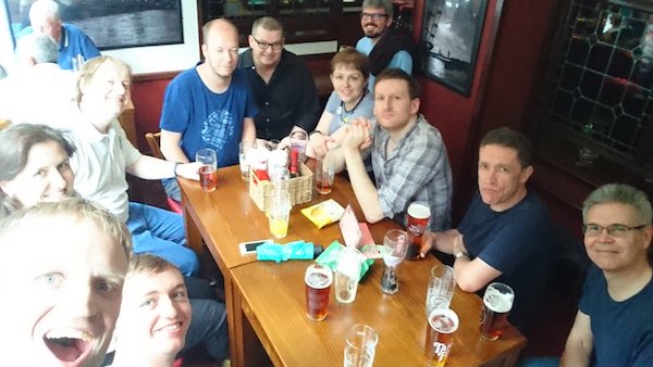
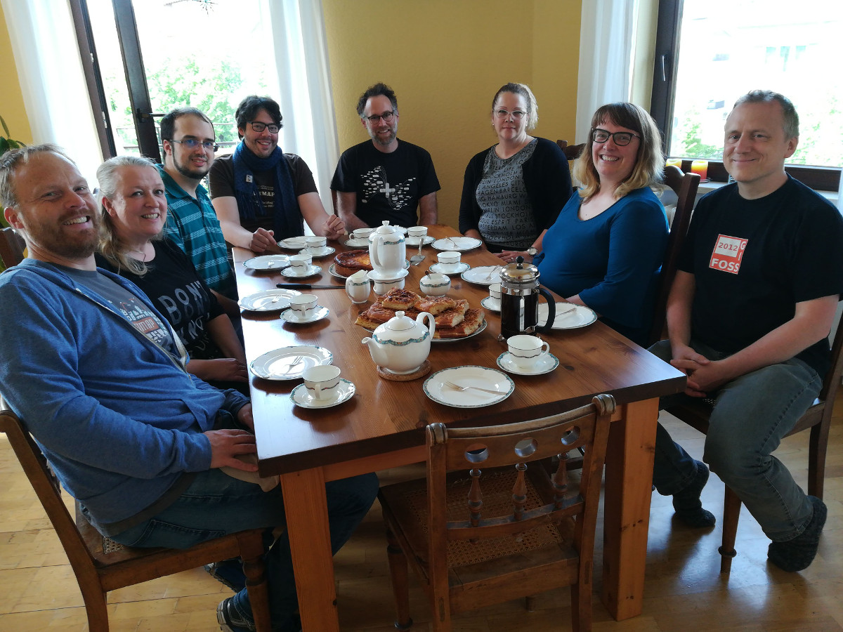
Like 2016 and 2017, the OSMF board had a face-to-face meeting again this year. This time, we met in Karlsruhe, Germany, at the office of Geofabrik. Meeting at Frederik’s and Christine’s place was a great choice and Frederik was a great host. In addition to having plenty of room to talk and work we even got home-made cheese cake from Christine (thank you!).

OSMF Board eating cheese cake after an invitation by Christine. © CC-BY-SA Dorothea

I had a short trip by car and arrived on Friday, 27th of April in the late afternoon and the official schedule started Saturday morning. Most of my colleagues, who had to take a longer trip by plane, arrived early on Friday or even Thursday and thus had the chance to meet at Frederik’s place for some early preparations and working on some OSMF stuff.

I don’t consider this post a detailed summary of what happened and what was talked about. It’s more about my thoughts about the meeting and about the most prominent topics we talked about. There will be more detailed minutes at a later stage.

Preparation

Like in previous years, we filled in a small questionnaire about our expectations and plans for this face-to-face meeting and once again it was Mikel who did a great job collecting the input and assembling a schedule for us. The schedule was less tight than in past years and we deliberately left some space for some last-minute topics. We also had some topics where it wasn’t clear if we could make it in the time set, so it was good to have some space for that.

Social interactions

One of the more generic recurring goals was to understand each other’s points of view, work and communication styles. I kind of find it funny how much such a meeting helps in that regard as it’s still a huge difference between reading, hearing and also seeing someone to get to know them better. And while most of us have met before, I think I still gained from it. Additionally it was Heather’s first meetup with the rest of us, so I took the chance to get to know her better.

On the mailing list we were asked about the value of the meeting, if it’s worth it. And as every year I feel the pain of giving a concrete answer to that. It’s hard to measure it as you don’t have any revenue to compare against. Anyway, I think the social aspect of the meeting is an important one. “Did they want to offend me?”, “Are they serious about that or was that a joke?”,… knowing someone in-person makes it easier to understand and classify a response. This makes overall communication easier and more productive I think. And given our organizational budget compared to the money spent, I guess my suggestion for future boards would be to just have a face-to-face meeting by default, without trying to ponder about its value.

Conflict of Interest

The topic about conflict of interest (COI) was a very difficult one and I felt the urgent need to talk about it early on. I thought that some other topics might pose a COI for some of us, so we should talk about COI first.

The problem that I have is that it’s very easy to construct a scenario where something might be a potential conflict of interest and as I wrote in a similar discussion on osmf-talk mailing list, you could easily argue that Mikel, as an employee of Mapbox, kind of always has a potential COI. Rightly Mikel told me, that it’s not hard for him to construct a case making me have a potential COI as well, for whatever topic we talk about.

I seemed to be very passionate about that topic as I got asked several times to explain myself and that the others perceived me as having a strong opinion on it. I actually did not, I had a lot of questions and I felt the need to answer them. We discussed the topic for quite some time, but only very few questions could be answered. Anyway, we agreed that we should have a guideline at some point. Until then, I’d like to invite you to take part in that discussion and share your thoughts on our mailing list. We are supposed to support the community and value their input.

The second conclusion was, that we could use some professional help. That’s why we wrote a mail to “our” lawyer to clarify some of the questions we had. E.g. the legal text about COI speaks about a COI if a person is director in two companies, which basically only applies to Frederik and Kate at best. But what about if you’re an employee in one company and director in the other, like e.g. Mikel or Martijn. The law reads as if that can’t be a COI. So independent of our guideline, such questions should be answered first and I hope we’ll be able to share them with the community soon.

Micro Grants

We had talked about micro grants before and somehow didn’t follow up or finish it. As I said, some of us had been in Karlsruhe on Thursday or Friday, so they took the chance to start working on it at that point in time and we continued to work on it on Saturday and Sunday together. I guess in the end we have a pretty decent plan.

I can’t estimate if micro grants will be successful or not, but I think that it’s a good idea to have something like that and to encourage people to take place in it. In the German chapter, the FOSSGIS e.V., we have something similar and in my opinion it has been proven to be quite valuable, so I hope the OSMF micro grants prove to be a similar success.

Anyway, I guess some more details will pop up on the mailing list soon and the program is scheduled to start at this year’s State of the Map.

Working Groups and Volunteers

This is the second topic we resumed from last year and I’m getting a bit emotional about that one. I love the OpenStreetMap project and its community, the amount of volunteering time spent on the project and the output, our great database and map.

Still I find it very sad that only very few people spend their time on helping to run the project. Almost all working groups suffer from a lack of volunteers, only very few people help developing code for the core services, almost no one participates in organizational discussions about the project and so on. So if you’re reading this post you most likely are not in a working group. Why? It’s so easy to join and help!

Anyway, we talked about ideas how to solve that and how to get volunteers to help. It was a tough topic and I think I was not really enthusiastic about any of the ideas. And in the end I felt the need to abstain from further discussion. I can’t say if there’s a conclusion to that, but one thing we felt is the need to better identify the needs of working groups. I guess it’s not obvious for everyone how much we lack volunteers to keep the project running.

Diversity and Communications

The diversity and communications topic was something I was afraid of as I considered everyone having a very strong opinion on that. At least I have. I thought we’d get into a fight over that, but all of us left without a black eye.

As I said in the begining, these are my thoughts and my opinions, so I don’t want to get into too much detail. But if I read e.g. this code of conduct, my blood pressure rises. I consider it very unfair, I can’t stand rules that know who’s guilty in advance and that consider insults acceptable if they are coming from the correct set of people. I also
dislike how the issue is often approached with a clearly defined “desired outcome”, instead of openly discussing real problems and their potential solutions.

Still, the discussion was not so bad after all. We split up into two smaller groups and I discussed with Frederik, Mikel and Kate and it was interesting to hear their opinions on it. I especially appreciate talking with Kate about it. She’s kind of passionate about the topic and she is able to provide very good examples and insights and she’s amazingly patient with people who ask silly questions :-). It helped me very much understanding other points of view. It didn’t change my mind though but I think the discussion gains much from people like her.

GDPR

The GDPR is a very important topic as it starts taking effect soon. We talked quite much about it and Heather took the lead on it. She was very well prepared and put considerable time into it. I think she’s also concerned with it in her professional life, so she knows what she’s talking about. I had some reservations that from the outside it would look like we’d overrule the LWG, but we ended up mostly devising strategies for the bits that fell outside of LWG‘s responsibility, and otherwise agreeing with their recommendations.

You can read more on the topic at several places, but I guess the most comprehensive information or summary can be found in Heather’s blog post here

Summary

I will abstain from a judgement on whether the meeting is worth the money or not. As Frederik put it some time back: We should just make it default to have a face-to-face meeting and that’s my suggestion for the boards to follow as well.

I think we did get some things done and meeting in person makes it easier, quicker and more productive. As I said above, I hope we’ll gain as a project from the micro grants. I also hope that we started a process to get a guideline for the conflict of interest and I’m eager to read the lawyer’s reply. I deliberately didn’t include details, as you’ll be able to read them in the minutes anyway. But I somehow hope that my post furthers the interest in our project and organizational topics. Please participate in the discussions and share your thoughts.

The State of the Map program is out!

Politecnico di Milano, inner courtyard. Photograph by Alessandro Palmas.

Read the program and immediately realize you can’t miss the next State of the Map 2018 in Milan.

In addition to many interesting talks and workshops, for the first time you can join the Academic Track: a full day session that aims to bring together and foster interactions between OpenStreetMap contributors and researchers.

You will meet OpenStreetMap enthusiasts from all over the world, and discover new local mapping efforts from the last year. The program features members of the community, researchers, new voices, experiences switching to OSM, crisis mapping, new technical tools, company perspectices, projects from every corner of the planet, big data management and much more.

The venue has two main rooms and four additional halls. If you need space for an impromptu gathering, you will always find at least one available room. And don’t be afraid to share your ideas: if you have a last minute idea for a lighting talk you can “book” a 5 minute slot by writing the title on the flipchart at the welcome desk!

Are you still in doubt? We are sure you don’t want to miss the social event on Saturday evening at Old Fashion, close to the beautiful Castello Sforzesco, with live music and drinks.

What are you waiting for? Hurry up and buy a ticket!

Your State of the Map team