Category Archives: Fun

Happy 18th Anniversary, OpenStreetMap :)

Cake for OpenStreetMap’s 18th anniversary, celebrated by OSM Bangladesh at BSMRSTU (Bangabandhu Sheikh Mujibur Rahman Science and Technology University). Photo by Sawan Shariar, CC-BY-SA 4.0

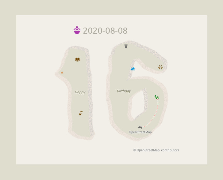
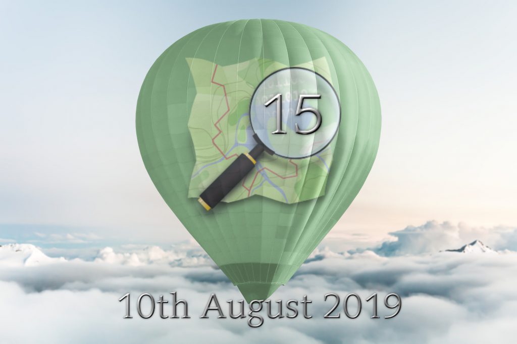
This Sunday, 7th of August 2022,
we are celebrating 18 years of OpenStreetMap!

Celebrations started the previous week and will continue for one more week. So, how do you plan to celebrate? 🙂

Planning to organise an online or in-person event? Please add your event to the OSM wiki! If wiki editing isn’t your thing, email communication@osmfoundation.org with your event details and we’ll add it 🙂

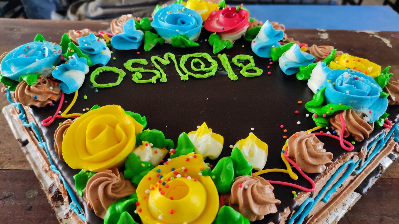
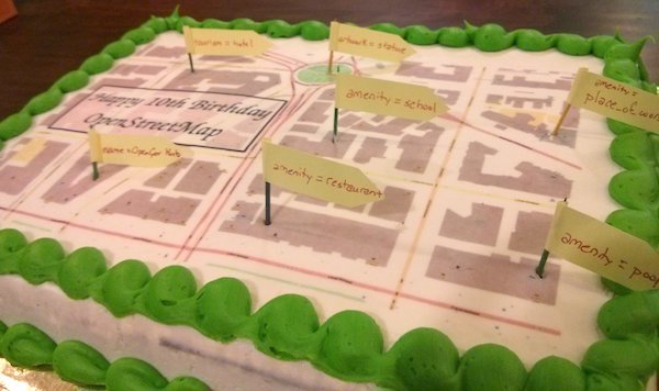
Making a birthday cake? See previous examples of OSM cakes for inspiration. Don’t forget the attribution!

You could post why you love OpenStreetMap 🙂 Remember to use the hashtag #OpenStreetMap18 on social media.

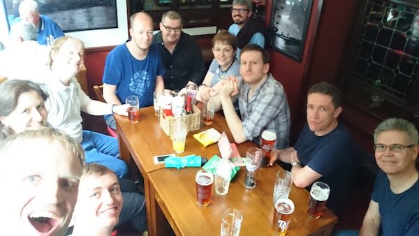
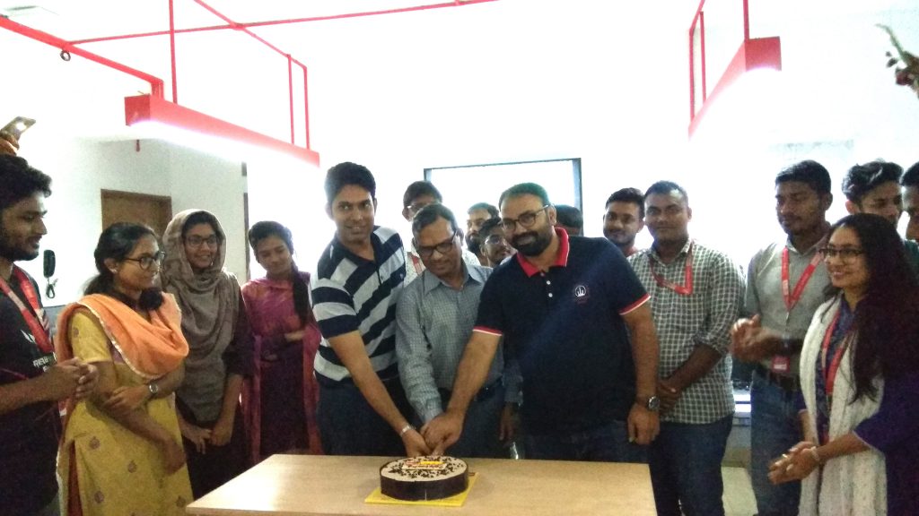
Posting photos of celebrations? If your photos are accompanied with the text “CC-BY-SA 4.0” (or another open license), we can add them to the OSM wiki (or feel free to add them yourself! ~ register here).

Or you could post a photo of yourself holding a written message 🙂 

Planning an online party or mapathon?

You can use the BigBlueButton video server of the OpenStreetMap Foundation! To get a free account and your own video room, please signup.

  • You can use your video room even after the birthday, for any OSM-related event.
  • Community members in low-bandwidth environments may benefit from using BigBlueButton’s low-bandwidth settings.
  • Please add your event to the OSM wiki! If wiki editing isn’t your thing, email communication@osmfoundation.org with your event details and we’ll add it 🙂

Join us!

Observance of the anniversary of the creation of OpenStreetMap is held on or about the 9th of August, which is the anniversary of the registration of the OpenStreetMap.org domain name. The concept of OpenStreetMap predates the domain name registration, but that seems a suitable anniversary date 🙂

Happy celebrations everyone 🙂


Get notified about new blogposts: Subscribe to the RSS feed!

Do you want to translate this and other blogposts in another language..? Please send an email to communication@osmfoundation.org with subject: Helping with translations in [language]

OpenStreetMap was founded in 2004 and is an international project to create a free map of the world. To do so, we, thousands of volunteers, collect data about roads, railways, rivers, forests, buildings, and a lot more worldwide.  Our map data can be downloaded for free by everyone and used for any purpose – including commercial usage. It is possible to produce your own maps which highlight certain features, calculate routes, etc.  OpenStreetMap is increasingly used when one needs maps that can be very quickly, or easily, updated.

Celebrating Earth and Space in Maps

April brings two international commemorative days that offer fun ideas for mapping. Earth Day on April 22 demonstrates support for environmental protection, and the less well-known International Day of Human Space Flight on April 12, which was created by the United Nations fifty years after Yuri Gagarin’s first human space flight.

These celebrations are intricately intertwined in the famous “Earthrise” image, which helped spark global environmental consciousness and led to the first Earth Day in 1970. The increasing availability of earth observation imagery since then has directly helped OpenStreetMap for the entire globe.

The Earth from the Moon, by NASA

There are plenty of opportunities for mapping related to Earth Day. You could map natural areas, reserves and parks, recycling facilities, and many other kinds of features mentioned in the Environmental OSM project.

And for the International Day of Human Space Flight, while OSM doesn’t map in outer space (yet), you can map terrestrial features related to space flight, like launch sites, space-related facilities, historic sites and museums, or even just things named for outer space.

Mapping Earth

The Environmental OSM project has a lot of great ideas, from the local to the global.

You could take a look at recycling-related tags and features, such as public recycling bins or recycling centres, and see if any are missing around you.

You could help map your favorite green space or natural area, whether it’s wilderness, a park, or something else. National parks and nature reserves are among many included in boundary=protected_area, or you could try mapping land use, wetlands, or mangrove forests. There are also clean energy facilities like wind power — are there any near you that aren’t mapped? Other ideas include cycling and hiking trails, or you could look to see if any polluting industries near you need to be mapped.

A windmill in the ocean

The Tasking Manager also has projects from various nonprofits related to environmental issues, such as mapping places with climate change-related risk.

Or you can take a look at places related to the environment: the United Nations Environment Programme is headquartered in Nairobi, Greta Thunberg’s first School Climate Strike took place at the Swedish Riksdag, and there’s even an Earth Day monument in Orlando, Florida.

Mapping Space Flight

There are many Earth-bound options for mapping space flight! OSM has tags for spaceports and launchpads and Wikipedia has a list of rocket launch sites including latitude and longitude coordinates. There are spaceports around the world too (via Overpass). You could take a look at some near you and make sure everything is mapped and tagged properly around them — or see if any are missing around the world. (Make sure to follow local tagging guidelines, though.)

A NASA launchpad

You also could make sure planetariums or space museums near you are mapped.

And there are some more amusing spaceflight-related places: for example, the Fremont Rocket sculpture in Seattle, USA and pubs like the Rocket in London and in Jena, Germany.

And of course, there are planty things related to non-human space flight, such as the UFO incident in Roswell, New Mexico, USA where there’s the International UFO Museum & Research Center, the Rendelsham Forest UFO landing sites in the UK and the flying saucer-shaped water tower Nave do ET (ET’s Ship) in Varginha, Brazil.

the Fremont Rocket in Seattle

Let us know what you map — and tell us about any upcoming days you think would be interesting for an OSM blog post.

Photo credits:

Earthrise: William Anders/NASA, public domain
Windmill: © Hans Hillewaert / CC BY-SA 4.0
Space Shuttle: NASA, public domain
Fremont Rocket: damnitgetmybeer/Mapillary, CC BY-SA 4.0

Celebrate the 16th OSM anniversary!

The 16th OpenStreetMap anniversary will be celebrated on the 8th of August, 2020! Image: Fictional map data rendered with the standard style of osm.org (osm-carto). CC-BY-SA 3.0, trademarks apply.

On Saturday, 8th of August 2020,
we will celebrate 16 years of OpenStreetMap!

Planning an online party or mapathon?

You can use the BigBlueButton video server of the OpenStreetMap Foundation! To get a free account and your own video room, please signup.

  • You can use your video room even after the birthday, for any OSM-related event.
  • Community members in low-bandwidth environments may benefit from using BigBlueButton’s low-bandwidth settings.
  • Please add your event to the OSM wiki! If wiki editing isn’t your thing, email communication@osmfoundation.org with your event details and we’ll add it 🙂

Other ideas

  • Post why you love OpenStreetMap. We will publish a collection of messages later 🙂
  • Post a photo of yourself holding a written message 🙂 
  • Use the hashtag #OpenStreetMap16 on social media
  • Make/order a birthday cake. See previous examples of OSM cakes for inspiration. Don’t forget the attribution!
  • If your photos are accompanied with the text “CC-BY-SA 2.0” (or another open license), we can add them to the OSM wiki (or feel free to add them yourself! ~ register here).
  • Do you have more ideas? Share them in the comments 🙂

Join us!

Observance of the anniversary of the creation of OpenStreetMap is held on or about the 9th of August, which is the anniversary of the registration of the OpenStreetMap.org domain name. The concept of OpenStreetMap predates the domain name registration, but that seems a suitable anniversary date 🙂

Get notified about new blogposts: Subscribe to the RSS feed!

Do you want to translate this and other blogposts in another language..? Please send an email to communication@osmfoundation.org with subject: Helping with translations in [language]

The OpenStreetMap Foundation is a not-for-profit organisation, formed to support the OpenStreetMap Project. It is dedicated to encouraging the growth, development and distribution of free geospatial data for anyone to use and share. The OpenStreetMap Foundation owns and maintains the infrastructure of the OpenStreetMap project, is financially supported by membership fees and donations, and organises the annual, international State of the Map conference. It has no full-time employees and it is supporting the OpenStreetMap project through the work of our volunteer Working Groups. Please consider becoming a member of the Foundation.

OpenStreetMap was founded in 2004 and is a international project to create a free map of the world. To do so, we, thousands of volunteers, collect data about roads, railways, rivers, forests, buildings and a lot more worldwide. Our map data can be downloaded for free by everyone and used for any purpose – including commercial usage. It is possible to produce your own maps which highlight certain features, to calculate routes etc. OpenStreetMap is increasingly used when one needs maps which can be very quickly, or easily, updated.

Celebrate the 15th OSM anniversary with a birthday party!

The 15th OpenStreetMap anniversary will be celebrated on 10th of August, 2019!
Image by OSM Communication Working Group, CC-BY-SA 3.0. OSM logo by Ken Vermette, CC-BY-SA 3.0 & trademarks apply.

The “Birthday” of OpenStreetMap is lost in the sands of time. Observance of the anniversary of the creation of OpenStreetMap is held on or about the 9th of August, which is the anniversary of the registration of the OpenStreetMap.org domain name. The concept of OpenStreetMap predates the domain name registration, but that seems a suitable anniversary date.

This year the anniversary will be celebrated on
10th of August!

Will you organise an OSM birthday party?

How to organise a community birthday party

  • Contact OSMers in your area and talk among yourselves. Decide what you want to do.
  • It can be as big or as small as you want. A few people meeting for some food/drink, or a bigger event.
  • Invite new people! It can be a great way to spread the word about OSM. Promote your event.
  • You can make/order a birthday cake. See previous examples of OSM cakes for inspiration. Don’t forget the attribution!
  • If you take photos, you can share them on the OSM wiki afterwards.
  • Edit this wiki page and put details of your event in.
  • Remember a core principle of OSM: Have fun!

If wiki editing isn’t your thing, email communication@osmfoundation.org with your event details and we’ll add it 🙂

Events are already planned in Japan, Belarus, Germany and the US.
Join us!


Do you want to translate this and other blogposts in your language..? Please send us an email to communication@osmfoundation.org with subject: Helping with translations in [your language]

OpenStreetMap was founded in 2004 and is a international project to create a free map of the world. To do so, we, thousands of volunteers, collect data about roads, railways, rivers, forests, buildings and a lot more worldwide. Our map data can be downloaded for free by everyone and used for any purpose – including commercial usage. It is possible to produce your own maps which highlight certain features, to calculate routes etc. OpenStreetMap is increasingly used when one needs maps which can be very quickly, or easily, updated.

Happy Birthday OpenStreetMap

Cake in Fukushima, Japan © CC-BY-SA 3.0  Ikiya and family

OpenStreetMap is 14 today! We’ve been partying in various locations around the world: Hyderbad, New Delhi, Moscow, Kigoma, Rapperswil, London, Washington DC, Denver, and Seattle.

Celebrations in London

Celebrations in Dhaka, Bangladesh, after a mapathon

If you missed the birthday party, don’t worry. Our community is lively with events happening all the time. You can see some of them listed on the current events list here, or find out more generally what’s happening in your country/city on the wiki.

Cake in Washington DC

The true “Birthday” of OpenStreetMap is lost in the sands of time. Observance of the anniversary of the creation of OpenStreetMap is held on or about the anniversary of the registration of the OpenStreetMap.org domain name (9th August). This year 12th August seemed like a suitable Sunday!

With over a million people making OpenStreetMap edits, and around 5000 people making edits on any particular day, it’s hard to imagine a time when all of this hadn’t even got started yet, But that time was 14 years ago, in the summer of 2004. We’ve come a long way since then. Wherever you are in the world, join us in saying “Happy Birthday OpenStreetMap!”

Participate in our poster competition!

Poster competition at SotM-EU 2014. Photo by Michael Reichert. Licence: Attribution 2.0 Generic (CC BY 2.0)

At State of the Map we love hearing what has been done with open map data, but we also love seeing it too. This year we’re taking inspiration from regional SotM EU conference and holding a poster competition. Your poster could show how well your home is mapped, it could be a beautiful new style or map. It might not focus on a map but instead focus on a community or statistics, it might be a poster explaining and inviting people to OpenStreetMap. What’s important, is we want it to be about OpenStreetMap.

Rules for the competition

  • Poster should be for A0 size (841×1189mm)
  • Poster should be about OpenStreetMap
  • One entry per person

How to enter

  • Upload your poster online
  • Send an e-mail to team@stateofthemap.org with the subject “Poster Entry
  • Include: a link to the image, title of the poster, your name(s), whether you would like to bring the A0 poster or for us to print it. The licence of the submitted works is considered to be CC BY-SA 4.0, unless noted otherwise on the image.

Deadline: 30th June 2018

With the entries

  • The SotM team hope to shortlist up to 20 posters that will be displayed during the State of the Map 2018 conference in Milan
  • During the conference, attendees will be invited to vote on their favourite posters
  • As of this time there are no prizes planned other than the satisfaction of sharing your poster with the State of the Map community.

You don’t have to attend SotM 2018 to enter this competition, but great conversations happen while viewing the posters so grab your SotM tickets here!

We have our winners!

A group photo of all the nominees on the stage of the State of the Map conferenceOn September 25th we announced the winners of the OpenStreetMap Awards, for which hundreds of mappers voted this month. The results are:
  • The Core Systems Award went to Roland Olbricht for the Overpass API.
  • The Innovation Award went to Manuel Roth and Lukas Martinelli for OSM2VectorTiles.
  • The Influential Writing Award went to the WeeklyOSM Team for their weekly news blog.
  • The Greatness in Mapping Award went to Martin Ždila for mapping a lot of hiking routes.
  • The Expanding the Community Award went to Pascal Neis for his community maps.
  • The Ulf Möller Memorial Award went to Frederik Ramm.
All the nominees are doing important work for improving OpenStreetMap, making it better and more visible. We cannot thank you enough! Also thanks to everyone who voted and to these who spend their hours on the open maps. Please continue the good work, and prepare to nominate each other for the next awards. See you next year!

Nominate Your Heroes for the OpenStreetMap Awards

Announcing the OpenStreetMap Awards, awarded for the first time this September at the State of the Map 2016 conference in Brussels!

This is a community award: nominees and winners are chosen by the community. We are now opening the Call for Nominees, to learn more about the amazing contributors to OpenStreetMap. The Awards strive to be a worldwide event for all OpenStreetMap members, including developers, mappers, community leaders, blog writers and everyone else. We need your help to find the best of OpenStreetMap globally.

Add your nominees on the awards website. There are six categories: Core Systems, Innovation, Writing, Mapping, Community and the Ulf Möller Memorial Award. You can nominate up to ten people, groups or organizations for each category. Eligible are projects or works that were announced after August 1st, 2015, except for the Ulf Möller Award, for which everyone is eligible regardless of the time when they were active in the project.

The call for nominees will close August 27th, and shortly after that we will start the second round, choosing the award recipients. Please nominate!

Ian White’s panel at Nav&Loc

Yesterdays closing panel, which overran substantially, was great. Bordering on hilarious. The panel included Christian Petersen of CloudMade, Darren Koenig from TeleAtlas and Duncan McCall of Public Earth. Podcast is here. Best quality I could get with my laptop mic.

Now you’re 5…

When you’re 5 years old you get asked questions like “What do you want to be when you grow up?” Well, OpenStreetMap is 5 years old and there are a few answers to that question. But maybe a good first answer would be “banned on Google Enterprise maps”. You must of made an impact by then, huh? And yes, it’s true!

[…] You agree not to, and not to allow third parties or Your End Users, to use the Services or Content: […] to use or display Tele Atlas’ US Address Points obtained from the Services on a base map comprised of map data or content provided by International Publishers NV, NavNGo Kft., NAVTEQ Corporation, OpenStreetMap Foundation, or Zenrin Co., Ltd. […]

Check it out on the Google Maps API Premier Acceptable Use Policy.