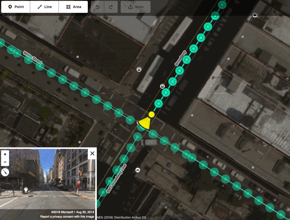
Interactive Bing Streetside viewer embedded in the iD editor © CC-BY-SA
We are excited to announce that you can now use Bing Streetside photographs when you edit OpenStreetMap using the web-based editor iD! This is the same imagery currently visible on Bing Maps. You can activate the Bing Streetside layer in iD by opening the Map Data pane (shortcut F). The new layer provides 360-degree panoramic imagery across large regions of the United States, United Kingdom, France, and Spain. The massive imagery dataset covers approximately 1.6 million kilometers and takes nearly 5PB of storage! Thank you, Microsoft.
Other street-level imagery datasets in iD
This street-level imagery dataset in an addition to the existing ones provided in iD by OpenStreetCam and Mapillary, which you can also activate by opening the Map Data pane (shortcut F).
If you find street photography helpful for OpenStreetMap editing, you can also contribute your own photographs, using the Mapillary and OpenStreetCam smartphone applications. These are developed by companies independent from the OpenStreetMap Foundation.
A reminder about photomapping
Are you a new mapper excited about photomapping? Please remember that on-the-ground survey is always superior, as photographs represent a specific time snapshot. Feel free to improve the map using photographs, just keep in mind that the photos might be old. Before changing someone else’s edits, consider contacting the mapper first.
Street-level imagery in other OSM editors
Street-level photographs are also available for improving the map in other popular OpenStreetMap editors, such as JOSM. The Bing Streetside imagery will probably become available in some of these editors soon, so stay tuned!
Happy mapping!
About iD
The iD map editor is an open source project. You can submit bug reports, help out, or learn more by visiting the project page on GitHub.
Pingback: Llegan las imágenes panorámicas de Bing Streetside al editor iD de OpenStreetMap
Pingback: Llegan las imágenes panorámicas de Bing Streetside al editor iD de OpenStreetMap | Bienestar Institucional
Pingback: Llegan las imágenes panorámicas de Bing Streetside al editor iD de OpenStreetMap - Exim Perú
Pingback: Llegan las imágenes panorámicas de Bing Streetside al editor iD de OpenStreetMap – Celulares y Tablets
Pingback: Llegan las imágenes panorámicas de Bing Streetside al editor iD de OpenStreetMap – Digitalks News
Pingback: Llegan las imágenes panorámicas de Bing Streetside al editor iD de OpenStreetMap | iOS Móvil
Pingback: Bing Streetside imagery now available in OpenStreetMap iD editor – GeoNe.ws
Pingback: weeklyOSM 416 | weekly – semanario – hebdo – 週刊 – týdeník – Еженедельник