Working Group Summary

Working Group Summary from 19 October to 04 November 2010

The second instalment of these periodic OSMF updates includes information from five Working groups and the OSMF Board.

Summary of License Working Group call of 19 October 2010

Meeting shortened due to only four in attendance.  Previous minutes approved.

Group discussion of “Scope 2” item from “Open Issues” page on the wiki.  Potential solution to be considered by entire group on next call.

Summary of Data Working Group call of 20 October 2010

The parties in a tagging dispute and endless mutual edit reversions requested intervention by the DWG.  The community advised the parties to behave.  Further edit-wars will be met with sanctions in the form of account blocks.

Suspected use of OSM data without proper attribution was brought to the attention of DWG. Assigned for contact by a DWG member.

Summary of SotM Working group call of 20 October 2010

Continued selection process from 06 October 2010 meeting.  – Vienna, Addis Abbaba, Cuba, Denver and Tallin submitted bids. Denver was selected.

Summary of License Working Group call of 26 October 2010

LWG considered a major revision to CT 1, potentially reducing it to some equivalent of the wikipedia terms, “Content that violates any third-party copyrights will be deleted.”

The discussion of “Scope 2” was raised with the LWG and discussed.  The proposed solution of user acceptance and per-changeset opt-out was met with general approval.  Further reflection and discussion to consider how this interacts with potential change to CT1.

Summary of OSMF Board call of 29 October 2010

The OSMF board will meet in person in Pisa, Italy on the weekend of 16 December 2010

The board meetings will be held weekly from next Wednesday onwards to increase throughput and reduce reaction times.

The initiative of a SOTM-EU for next year is welcomed by the board but it is unlikely that active support can be expected from the board or the working groups due to limited resources, which will focus on the main SOTM in Denver. The recent (main) SOTM conferences have provided a net income to the OSMF financials and therefore the board does not see a need to provide funding to any regional SOTM.

Summary of Communication Working Group call of 01 November 2010

Analytics configured and implemented for blog.osmfoundation.org (this blog)

CWG approached for link from osm.org to OpenGeoData.org.  Deferred until larger conversation on osm.org front page revisions.  Existing link to OGD from blogs.openstreetmap.org with other community blogs.

CWG still seeks guidance from theme / style -knowledgeable folks in mediawiki and WordPress.  Do you know about these things?  Help point us in the right direction!

CWG to continue to solicit other WGs to assist in these summaries.

Summary of License Working Group call of 02 November 2010

Further discussion of reducing CT 1 to a very short clause somewhat similar to Wikipedia’s “Content that violates any third-party copyrights will be deleted.”

LWG notes the prompt reaction to and resolution of a license issue in Colombia.  Thank you to all involved in this resolution.

A use of OSM data in a television commercial without attribution was brought to the attention of the LWG.  Requires community input.

Summary of Data Working Group call 03 November 2010

Previously mentioned contact (Oct 26) still pending.

Continued encouragement for DWG to take responsibility for moderation on mailing lists, etc.  Members of DWG have little enthusiasm for this proposal.

DWG are monitoring the response of company regarding improper attribution of OSM data in Chile.

DWG are following up an offer for improved data regarding an official source of 12nm data.

Summary of OSMF Board call of 03 November 2010

Backlog tasks were assigned for resolution.

Summary of SotM Working group call of 03 November 2010

Introductions between Denver local team and OSMF team.

Summary of Strategic Working Group IRC Chat of  04 November 2010

Initial working meeting for the Strategic Working Group was held on IRC in #osm-strategic.  With a full dozen in attendance discussion was lively on the matter of setting a policy for including additional tile layers on the osm.org front page.  This conversation will continue at the next meeting.
State of the Map 2011: September 9-11, 2011

November 4, 2010

The State of the Map (SotM) organizing committee announces the dates for the 2011 International conference for OpenStreetMap (OSM). An anticipated number of over 250 attendees will meet September 9-11, 2011 in Denver, Colorado.

“September is a delightful time of year in Colorado! The typically mild weather allows for plenty of extracurricular activities to enjoy; from a Rockies baseball game or touring a local microbrewery to hiking or taking a late summer drive in the mountains, there’s so much to do.” says Ariann Nassel, volunteer with the SotM local organizing committee.

The dates were chosen to be before the FOSS4G conference held in Denver, September 12-16. It will allow people interested in both events to enjoy both SotM and FOSS4G within one trip.

A fun competition for the the 2011 SotM logo will be announced soon. The call for papers, sponsorship details, volunteer opportunities and more information will be available before the end of the year.

Follow State of the Map:

Twitter #sotm

Www.stateofthemap.org

team@stateofthemap.org

Project of the Week: Pharmacy

Have a toothache and the dentist will see you tomorrow? Perhaps a
mild analgesic will help you sleep restfully. New shoes are a little
tight? This bunion cushion might take the pressure off while your
shoes and feet adjust to each other. The pharmacy might not be your
first choice of a place to be but you’ll be happy to find a pharmacy
that’s open late, in a strange town, when you need one. Let’s add the
local pharmacies to OpenStreetMap.

Learn more about this Project of the Week and how to add pharmacies to the map in your neighbourhood.

http://wiki.openstreetmap.org/wiki/Project_of_the_week/2010/Nov_03

This is your Project of the Week. Make suggestions. Inspire other
mappers. What is it about contributing to OpenStreetMap that
interests you? Postboxes? Bowing alleys? Share your OpenStreetMap
interests by contributing a Project of the Month.

http://wiki.openstreetmap.org/wiki/Project_of_the_week/Proposals

Farmacia photo by manfrys http://www.flickr.com/photos/manfrys/
is licensed CC-By-SA http://creativecommons.org/licenses/by-sa/2.0/

Image of the Week: Aerial photography

Media_httpimgurcom2ox_qxllo

This Image of the Week includes two images for the same great price.
OpenStreetMap contributor Mala holds the OSMcopter, a kite used to
collect aerial imagery. OSM contributor balrog-kun took the photo and
created the imagery server.

The OpenStreetMap logo printed on a 350 cm (11.5 ft) Sutton
Flowform-type kite made for making aerial imagery. These kites are
produced by IKAR in Poland (among others). On the right is an example
picture taken on 2010-10-20 over Praga district of Warsaw

See more details in the full size photo or on the aerial imagery
server. I keep looking for the pilots on the ground.

http://ooc.openstreetmap.pl/kap-warsaw.xhtml?lat=52.2486&lon=21.091&z=19

This is a Featured image, which means that it has been identified as
one of the best examples of OpenStreetMap mapping, or that it provides
a useful illustration of the OpenStreetMap project.

If you know another image of similar quality, you can nominate it at

http://wiki.openstreetmap.org/wiki/Featured_image_proposals

How do OpenStreetMap and open government geodata fit together?

In a recent post, I was examining whether OpenStreetMap is a suitable place for open governmental geodata by cross-checking if the OpenStreetMap is compliant with the ten principles for open data. Out of the ten principles, nine can be considered compliant and one non-compliant. Meanwhile, I have discussed this topic with a wide range of people and read many articles.  However, I have not yet found any place that would be perfect for open governmental geodata, not with ESRI or elsewhere.

In addition to the ten principles, another requirement emerged that was almost always stated by the authorities that look for publishing data: The data should not only be available for download in a machine-readable format, but a user should also be able to visualise the data.
Finally, I came up with a solution that fulfills all of the requirements: publishing the geodata through the OpenStreetMap tool chain under a public domain licence. This would not only fulfill all of the requirements, but also offer some additional advantages.

What would this look like?

The OpenStreetMap tool chain is the underlying software that is used to store, edit and display the OpenStreetMap data – independent from the data licence. The default tool chain is open-source software that is free of charge and has been thoroughly tested by the more than 300.000 registered users.

The tool chain can be established with a blank database that serves as a target for the authority’s dataset, which is intended to be opened. It can be run by any hosting provider. When the tool chain is set up, the authority can import its data into the empty database and then release it under a data licence of its choice.

The infrastructure enables a machine-readable download of the data, displaying the data on the Web or accessing it through the API of the tool chain.

Unknownname

* refers to the ten principles for open data

What are the additional advantages?

The authority can publish the dataset by making use of the OpenStreetMap infrastructure without being bound to the OpenStreetMap licence. As the tool chain is free of charge, costs apply only for establishing and running the infrastructure.

In addition, a dataset that is published through the OpenStreetMap tool chain can be easily imported into the OpenStreetMap data so that the OpenStreetMap community can benefit from the data.

The authority also has the option to make their data available in a read-only or editable form. In the case of the latter, everyone who can edit the OpenStreetMap data is also able to edit the authority’s data, as editors such as JOSM or Potlatch would be fully functional on the authority’s dataset.

Who can help?

In principle, everyone who is involved with OpenStreetMap can assist. A handful of companies exist that are in position to establish such an infrastructure, provide guidance and import the dataset into a “blank OpenStreetMap database”. The selection process for the right integration partner could be performed by a tender process. However, the company that is probably most suitable is Geofabrik in Karlsruhe, Germany. The company has several years of experience with the tool chain and it knows how to convert and import datasets of any format.

Tricky Transit Data. Is Transiki the Answer? | It’s All About Data

I have always loved working with transit data. It is so similar to road data like TIGER or OSM that we work with so often, but at the same time it is so much different. While a road network stays the same throughout time, a transit network can change depending on the time of day, or day of the week. This makes working with transit data a much more difficult problem than working with street data, in fact transit networks generally include street networks within them!

Services on top of transit data are somewhat more rare than road network services. Google has had Google Transit for several years now and is slowly expanding to include more cities. Microsoft recently added transit data for a few cities to Bing Maps. These services are great, I honestly don’t think I would be capable of using transit anymore without Google Transit on my iPhone, but what about the data?

Google has opened the General Transit Feed Specification interchange format they use to load data from transit companies into their system, and there are some efforts to make public GTFS data easy to get, as well as a number of very powerful tools that can suck in a GTFS dataset along with an Open Street Map road network for analysis and routing (BTW, GTFS is just a standard schema represented in CSV files, so working with it in FME is very easy too – kudos to Michael Grant of BC Transit who had a great presentation on this topic last week).

Transiki is a new project from Steve Coast (yes, the same Steve Coast who started OpenStreetMap) to bring the OSM model to transit data. Steve says he had the idea when Google Transit failed him, leaving him on a platform waiting for a train that did not exist, except in Google’s datasets. With Transiki, Steve may still have been stranded, but at least he could update the dataset to prevent others from being in the same situation. A wiki-esque transit network could also bring the real-time transit data in The Bay Area or Portland to other cities through a Waze like application. The uses for a large, free transit data network are almost limitless.

Will Transiki prove to be the answer to all of our transit woes? The short answer is nobody knows for certain. As with all crowdsourcing initiatives, only time will tell if the support from the community remains and grows. Given the huge success of OpenStreetMap, I am excited and hopeful. To get involved with Transiki, come join me on the mailing list!

ShareThis

Related posts:

  1. Full Speed Ahead with OpenStreetMap
  2. Trends in Spatial and Temporal Data
  3. Open and Accessible Data
  4. GIS Folks, Ever Metadata You Didn’t Like?
  5. Choosing the Right Data Format

Project of the Month: Stay a While

Where do you stay when you travel? Sometimes we stay with friends and
family and we already have those places mapped. What about hotels,
motels, hostels, camp grounds and caravan parks bed and breakfasts and
guest houses? When we map at home, these amenities for visitors can be
invisible to us. Let’s turn that around and map the places for
visitors in our towns.

Where do people stay when they visit your town? Find out how to add
these features to the map on the OpenStreetMap wiki page for this
Project of the Month.

http://wiki.openstreetmap.org/wiki/Project_of_the_week/2010/Oct_27

This is the a Project of the Month. Project of the Week returns
next week, while PotM will continue until December. These projects
inspire mappers to contribute data they might not have considered
previously, and allow us to be inspired by the projects of other
mappers.

This is your Project of the Month. Make suggestions. Inspire other
mappers. What is it about contributing to OpenStreetMap that
interests you? Postboxes? Bowing alleys? Share your OpenStreetMap
obession by contributing a Project of the Month.

http://wiki.openstreetmap.org/wiki/Project_of_the_week/Proposals

Hotel room photo by prayitno

http://www.flickr.com/photos/34128007@N04/

is licensed CC-By

http://creativecommons.org/licenses/by/2.0/deed.en

Image of the Week: OSM-derived typography maps

Media_httpimgurcomixx_wmehd

We saw these maps a few weeks ago, and now they have been recognized
as Image of the Week. As described by the creators at Axismaps:

These unique maps of Chicago and Boston accurately depict
the streets and highways, parks, neighborhoods, coastlines, and
physical features of the city using nothing but type. Only by manually
weaving together thousands upon thousands of carefully placed words
does the full picture of the city emerge. Prints are
available.

Very nice, and perhaps these are just the gift for your favourite
mapper, once you have already picked up a copy of each of the new OSM
books for them, of course.

http://www.bookdepository.co.uk/book/9781906860110/

https://www.packtpub.com/openstreetmap/book

See more pretty maps and wonderful photography of maps on the Axismaps web site.

http://www.axismaps.com/typographic.php

They have a blog entry describing the process of creating these maps, as well.

http://www.axismaps.com/blog/2010/09/typographic-map-posters/

This is a Featured image, which means that it has been identified as
one of the best examples of OpenStreetMap mapping, or that it provides
a useful illustration of the OpenStreetMap project.

If you know another image of similar quality, you can nominate it at

http://wiki.openstreetmap.org/wiki/Featured_image_proposals

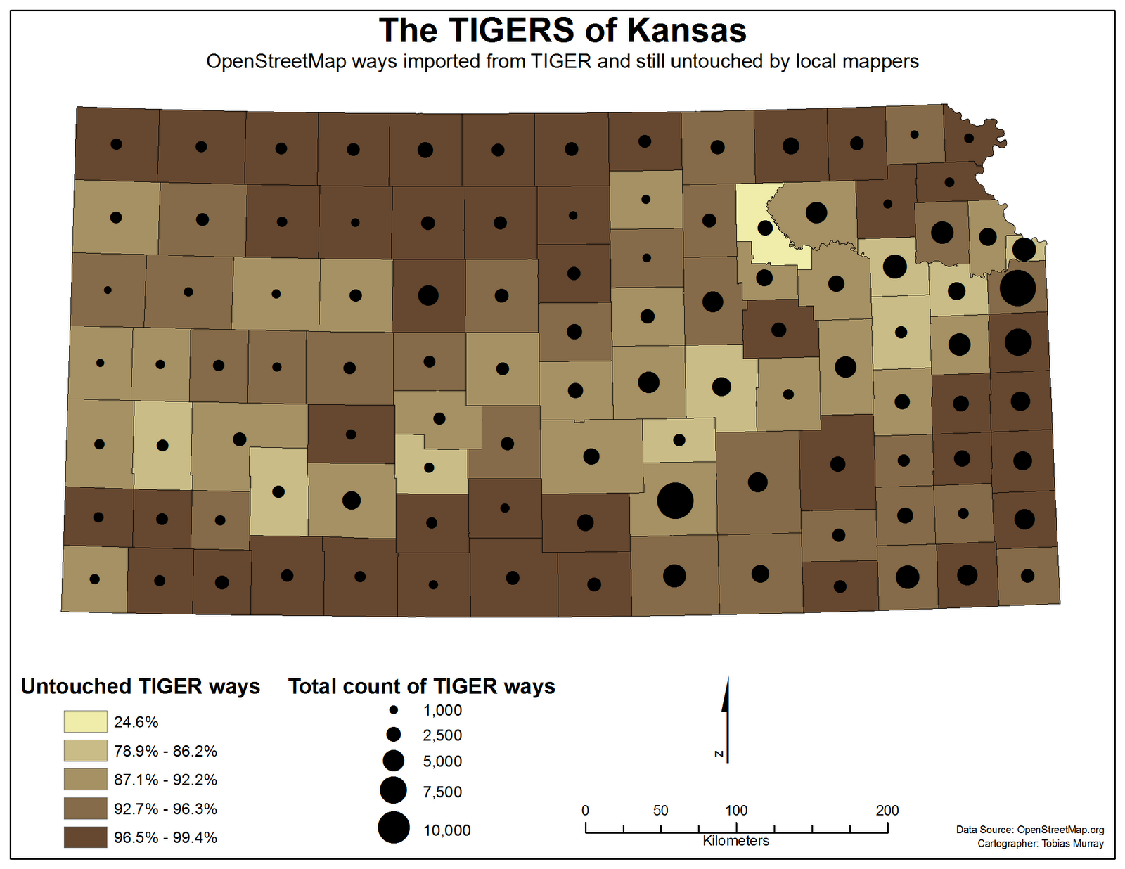
I do not think we are in Kansas any more

Media_http2bpblogspot_ujhqg

OpenStreetMap contributor Toby Murray has had a look at OSM data in
Kansas, with an eye towards roads un-edited, towards automated edits
and towards the upcoming census. What did he find? In part, he found
that he is making a difference.

There are 105 counties in Kansas. 104 of them still have
have 78% of their TIGER data in its original state. One has had 75% of
it modified. Yes, this is the county I live in. Yes, most of it was
done by me. Yes, this inflates my ego.

Share with Toby, the joy he takes in seeing the results of his
participation in OpenStreetMap and read his article on his newly
minted blog.

http://ksmapper.blogspot.com/2010/10/tiger-ways-in-kansas.html

See the OpenStreetMap coverage evolving

There has been a lot of buzz regarding OpenStreetMap during the last days e.g. here or here. However, I learned from several people that they did not understand why interest in OpenStreetMap has increased e.g. here. I thought it is time to visualize some of the recent map development. ITO has done some very nice visualization on OpenStreetMap but I thought a time lapse video on the evolution of the map is missing. Just watch the video for the European map and see if the buzz is justified.

[vimeo http://www.vimeo.com/16148504 w=500&h=283]

There are other versions for Germany only and (slower) versions for Europe in Full HD and Germany in HD.