Author Archives: Oliver

Join OSM PLUS – the OpenStreetMap Commercial Users Summit

Osmplus

Henk Hoff and I have been working with Steve Coast to develop the idea of a OSM commercial users conference. We have called it OSM PLUS – the OpenStreetMap Commercial Users Summit (http://osmplus.co/). Here is the announcement email:

The OpenStreetMap Professional Large Users Summit is going to be held just after SOTM US, on June 10th in San Francisco at the Marriott Union Square. You can register here. Be quick, space is limited.

OSM PLUS is new and focused on professional users of OSM data and toolchains commercially, academically, in government and elsewhere. It is a paid-for event and we expect it to be more of a conversation than a traditional presentation. Many professional users have similar concerns and expectations for OSM. We want to explore these in an environment focused on coming up with solutions.

Today, OSM is a volunteer-only organization. This focus doesn’t always satisfy the needs of many users. We want to have an open conversation about ways to make OSM better. Because of that, the program will be influenced by those who attend.

PS you can use the code “GPS” to get 20% off the ticket price if you register soon.

Some European OpenStreetMap growth statistics

I often get requests about the growth and competitiveness of OpenStreetMap in regards to commercial maps. While OpenStreetMap excels especially when it comes to details, people want to see figures that are more comparable to the commercial maps – mainly navigatable road networks.

I came across some internal evaluations of the recent planet files and thought I just share those figures figures with. These statistics are Europe related and show the values separated for Western and Eastern Europe.

In general we can report a healthy growth over the last 9 months – despite the license change that caused some loss of data.

Osm_drivable_roads_europe_cc

The drivable road network continues to grow in Western and Eastern Europe. While some countries like Germany have more or less reached 100% coverage of the driveable road network, others still have potential. In Eastern Europe I want to stress the growth of Turkey by 39% and Russia by 19%. In Western Europe we see Spain growing by 18% and France by 19%.

Osm_turn_restrictions_europe_cc

Turn restrictions show a strong growth – Eastern and Western Europe alike. Saturation has not been reached in any country –even Germany has grown by 34%.

Osm_segments_europe_cc

The overall growth of road segments shows an uptake after the license change had been completed.

Overall we see stronger growth in Eastern Europe, which means the gap between Eastern and Western Europe is narrowing.

This is showing just an extract of available data but allows extrapolation with a good confidence level. If you have questions don’t hesitate to contact me.

WhereCamp XMas edition [Berlin]

Unknownname

Dear friends of OSM,

We are proud to announce that the global concept WhereCamp is coming back to Berlin on 7th of December at Beuth University. Our purpose is to offer to geo communities the opportunity for sharing the newest projects in the area. That’s why we would like to invite you to this great event and to bring into discussion some of the innovative projects that might be interesting for our community.

The success of our WhereCamp summer edition, held this past June, brought more than 250 participants, involved in constructive debates and innovative presentations about location industry trends.  Now, it’s time to talk about what’s ahead for 2013.

Until now we have more than 90 participants registered and some OSM members have joined us too.

Be aware that attendance is free and opened to everyone.  We also want to remember you that participants will drive the content of the sessions of the day, following the usual barcamp format.

For more details or suggestion that you have please contact us at berlin@wherecamp.de

In the same time feel free to share this event with people who might be interested.


Yours sincerely,

(WhereCamp) Organizing team


Unknownname


0unknownname

New OpenStreetMap maps website with state-of-the art features by skobbler

Iegidhgg

OpenStreetMap is the best map when it comes to attention to detail. However, the experience of the map sometimes lags behind when compared to commercial implementation of the web-based maps. skobbler made an attempt at a new web-based map powered by OpenStreetMap: http://maps.skobbler.com.

There are some innovative features that were always missing with other solutions:

  • Auto-positioning via HTML5 browser positioning in Firefox and Chrome (if the user allows it)
  • Internationalised style in Germany and the US (coming to many more countries)
  • Drag & Drop Route calculation (just move the pins where routes should be calculated)
  • Multi-line address search
  • POI layers

Performance is very effective due to use of:

  • Modern and Fast map JavaScript Engine based on Leaflet
  • High-performance map tile loading due to worldwide big chunks of pre-rendered tiles (not only in the US)

Furthermore, there is a new map style with a good compromise of details and clarity. The address search for route calculations is temporarily based on a 3rd party geocoder (in default mode), but allows a single line address entry and very effective address coverage. 

Give it a try: http://maps.skobbler.com

OpenStreetMap and Indoor Maps [Part 2/2]: The mapping proposal for OpenIndoorMaps [by Marcus Götz]

Ijfbgjjc

Following our first post on the challenges and opportunities of an indoor-extended OpenStreetMap, we now wish to concentrate on the specifics and provide a proposal for “OpenIndoorMaps”. Before doing this, we provide some use-case scenarios that our proposal addresses.

Use-Case scenarios for OpenIndoorMaps

There are many possibilities or use-case scenarios for indoor maps or services such as routing or navigation. Imagine being a businessman at the airport: after entering the entrance hall you first want to go to the check-in counter and then to a nearby newspaper shop before searching for the lounge and then finally going to the gate. Normally you have to do this “navigation” by yourself, which can be quite a challenging task (especially in huge airports such as Chicago or Beijing).

Another example is the following: you are visiting a huge shopping mall. Unfortunately you do not have much time, thus you need proper guidance inside the mall. Luckily, you have your OSM based indoor routing application on your mobile phone, which means that you can easily locate your desired shop or item and receive proper routing instructions inside the mall. Besides these two use-cases there are plenty of other scenarios such as navigation in hotels (imagine being in Dubai in the Burj Khalifa with more than 100 floors or in the Venetian Resort in Las Vegas with more than 7000 rooms), in universities, in museums, train stations and so on.

As you can see, there are many meaningful examples of why indoor information is so important.

The indoorOSM model proposal

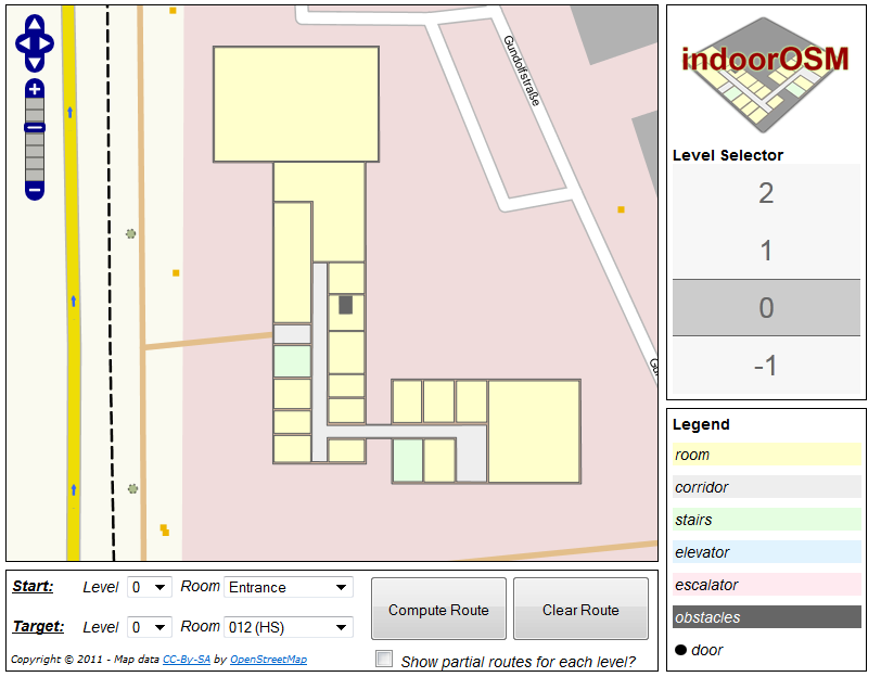
Basically, a building is represented as a feature (technically as a “relation”), whereby an attribute characterises it as building. One of the well known features of OSM is the fact that all kinds of additional building information such as the name or type can be attached to it. Every floor within the building is assigned a floor level while every entrance or exit of the building receives a unique ID in order to create a connection between the outdoor world and the indoor. Each floor is then assigned a corresponding level, (“floor-relation member”) such as level_0, level_1, level_-1 and so on (level_0 always denotes the ground floor).

Each floor of a building (technically each relation-member of the main relation) is again mapped separately, whereby a specific floor level is selected during the editing session.

Different building parts of a floor are mapped as room, hall, corridor, and so on. Each part of the building can contain features such as windows which can be described (tagged) in detail. Vertical connections are mapped as elevators, stairways and so on. A vertical connection can be connected to several levels (e.g. an elevator) or a single level (stairs).

Extend the model to your needs!

A full technical description can be found here: http://wiki.openstreetmap.org/wiki/IndoorOSM. Please do not hesitate to come up with proposals on how to improve and extend the model!

Start mapping a building yourself!

Start mapping a building yourself: Just open the JOSM editor, zoom to the location where the building is and start mapping the level shell as well as the building parts of one level (for example the ground level), and finally combine them in a relation. Afterwards, you can hide this relation (thus all ways will be invisible) and start with the next floor. When you have finished mapping all of the floors, simply create the building relation and add all floor-relations as relation-members.

Look at your result!

Currently, there is no automated integration process of indoor maps into http://indoorosm.uni-hd.de. Therefore, if you have mapped a building, simply send a short notification to m.goetz [at] uni-heidelberg.de (mentioning the relation id of your building) and your map will be integrated as fast as possible.  In the long run, a version with automated building integration can also be developed – assuming that there will be more and more building mapped indoors.

OpenStreetMap and Indoor Maps [Part 1/2]

Gieifegi

In most countries, OpenStreetMap played catch-up with the commercial maps. Indoor Maps are a completely new playing field. So far, none of the commercial providers have gained traction in the Indoor space. It is also an area where OpenStreetMap could take the lead and leave the commercial providers behind straight from the beginning. Wishful thinking? Maybe, maybe not. On the one hand, there is a lack of an Indoor approach for OpenStreetMap. On the other hand, there is no other map data with such attention to detail.

Now there is also a very promising approach to Indoor Maps for OpenStreetMap by the University of Heidelberg and especially Marcus Götz, who is co-author of this post and who will present his approach in a succeeding post. In this post, we want to give a better idea of the opportunities and challenges for “OpenIndoorMaps”.

The opportunity

Germany has reached a leading position with regard to coverage in the OpenStreetMap universe. Around the Reichstag in Berlin, every single tree is mapped. In the Berlin zoo, every single animal compound is mapped. So, what’s next for mappers in those densely mapped areas? An obvious answer is to go indoors.

The indoor space is the last frontier in mapping, and people are seeking and even expecting their well-known outdoor applications (e.g. navigation or local search) being adapted to the Indoor context. However, for transferring applications like openrouteservice.org or osm-wms.de indoors requires details about indoor spaces, and buildings need to be mapped inside. This is where the OSM community can build upon their strength of local knowledge and their attention to detail and as a result beat commercial data providers.

The key difference

Indoor applications require maps on top of each other to deal with floors. Floors need to be connected to each other. Floors need to be considered during capturing and during rendering. Different data is overlaid with each other, thus an appropriate methodology for capturing and visualizing the data is required. Especially a tall  building with several floors results in many super-imposed ways when mapping the rooms, corridors and floor shapes in OSM, which makes the OSM mapping some kind of inconvenience (at least for inexperienced mappers). Mapping indoors results in a huge amount of data for a comparable small area.

The challenges

Capturing and rendering floors – How can different floors be mapped in OSM? What is an appropriate visualization of multi-level buildings? How can the OSM map be extended for indoor information?

Privacy protection – Can the indoor space be mapped without limitation or are their additional privacy concerns to be considered?

Indoor Measurement – What technology do people need to capture indoor maps? Which gadgets will take over the role of the GPS receiver for street maps? Is there some kind of publically accessible building information available?

The Indoor Approach by the University of Heidelberg

The Indoor Approach of the University of Heidelberg focuses on dealing with the concept of floors. Thereby, each floor is mapped in great detail, thus the shapes and geometry of rooms are also included. The developed approach builds upon the existing OSM technology with ways and nodes, and combines them with relations to a building. Additional information about doors or semantic information, such as room names, is also included.  Essentially, a building can be fully mapped with existing OSM editors (mainly Potlatch or JOSM) and no additional extensions are required. Similar to other applications, the data can then be used for the creation of indoor maps and other applications.

Part 2 of this post will describe the approach in more detail and intends to encourage a discussion to include the community in development of a feasible approach for the OpenStreetMap community.

Directions (and correcting erroneous routing behavior) with OpenStreetMap

Many people are wondering how they can get directions with OpenStreetMap. Currently, there is no ‘directions feature’ on the website, OSM.org. However, there are methods to get directions based on OpenStreetMap data. Probably the most sophisticated web solution is open.mapquest.com.

Moz-screenshot-1

You can enter a starting point and a destination, either as an address or POI. Alternatively, you can right-click on the map and select a location as a starting point, and a destination respectively. Directions can be optimised for cars, bicycles or pedestrians.

If you want to report a problem with the directions you can do this in MapDust.com or directly in open.mapquest.com. Also, if you want to work on routing problems, MapDust shows you all the reported problems and gives you the opportunity to adjust a route around a problem to see how the map redirects the engine functions around the problem in real-time. More information can be found in the wiki resource.

Moz-screenshot

Update:

There are other tools that might be wortg trying e.g. http://maps.cloudmade.com/ or http://www.openrouteservice.org/

Where 2.0 sentiments: crowdsourcing is the way to go for map makers

Moz-screenshot-4

When I first was reflecting on the Where2.0 2011 conference, I had the impression that there were no real highlights and hardly any new trends. Navteq was announcing their 3D cities in an attempt to catch up with Google. Microsoft are advancing their map technology and announcing some major players are to switch from Google to Bing maps. Google launched Earth Builder – a tool to bring geographic data from non-profit organizations into the cloud, directly competing with ESRI’s ArcGIS online. Hardly any breaking news here.

However, there is one trend that becomes clear: all players are entering or strengthening their crowdsourcing initiatives for building maps. Often this approach was just mentioned as incidental or sold differently to audience: Google has extended Map Maker from the remote countries to the US. Similarly,  Navteq has launched a Wiki-map approach in Ethiopia, following the path taken by Google and trying this approach in remote countries first.

Microsoft launched Photosynth, a free tool on the iPhone to generate geocoded panorama images. It was not mentioned explicit but it seems it is intended to advance the Google ‘StreetView’ approach to places that cannot be covered by cars; especially indoors.

I wonder if the users are willing to do mapping efforts for the big corporations that keep the map data under a commercial license. Google is trying to shift respectively, extending the mapping efforts from India, where costs are low,  to volunteers that work for free. The question is if people (and organizations) will just make sure that their home place is shown correctly or if people are indeed willing to bring the commercial maps to a new level of detail as it is seen in OpenStreetMap.

skobbler introduces MapDust.com: A state-of-the-art bug solution

There is a huge gap between passive and active OSM users. In most regions, the map is maintained by a small number of users. Not everyone who intends to improve the map is capable of doing so. OpenStreetMap editors require a learning curve, as editing a map is not intuitive.

Clip_image002

However, there seems to be a much broader willingness to improve the map through the feedback channel. The GPS turn-by-turn navigation skobbler receives up to 1.000 suggestions for improvement per day. We have seized this suggestion and extended the skobbler feedback channel to an independent bug tool for the OpenStreetMap community: MapDust.com – a state-of the art bug tool.

Clip_image004

Bugs can be accessed through the Geo-RSS feed and the MapDust JOSM plug-in

The integration of the feedback channel has significantly simplified providing bug reports for the consumer. The number of incoming suggestions was overwhelming, even if not all of the reports have been helpful or relevant. To date, the feedback channel has been focused on the consumer, and that this why many of the bug reports “got stuck in the channel”.

We are now working on the other – the mapper’s part – to create a Geo-RSS feed and a JOSM plug-in to distribute the bug reports to the location where they can be processed.

Clip_image006

Why create a new tool if similar solutions exist?

We have seen that OpenStreetMap editors are very advanced. However, the tools for consumers to provide input have been neglected. Great editors like JOSM and Potlatch (2) exist as well as tools like the OSM Inspector. We want to provide a system where more input and contributions are received from people who only contribute on an occasional basis.

Filter allows a selective approach towards bug types

We simply wanted to increase the number of contributions by designing a slick and lean user interface. We see enormous potential to improve the map in many different aspects such as bus stops and house numbers.

We have received comments that the skobbler feedback channel contained bugs that are only very selectively relevant. Therefore, with the integration of filters, one can hide bugs that are not of interest.

Clip_image008

The Geo-RSS feed

You can submit suggestions and change requests for a specific region by selecting the desired map view, setting the filters and pressing the “subscribe RSS feed” button.

Clip_image010

Once subscribed, you are provided all new bugs that match the selected region and filters. Each feed post contains a small map view and the corresponding data as well as links to open the bugs directly in the JOSM or Potlatch editors.

Clip_image012

The wish list

Most of the MapDust features have been documented in the Wiki. We have also included a section entitled “wish list”. If there is anything you would like to see changed or added, please add your request to the wish list.

We wish you a happy 2011 and happy bug fixing!

Your skobbler Team