Weekly OSM Summary #17

May 3th, 2011 – May 15th, 2011

A summary of all the things happening in the OpenStreetMap world.

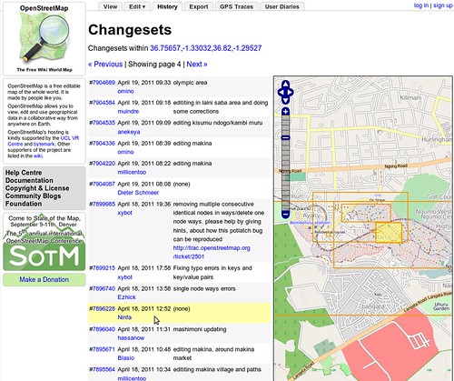
  • OSM.org was updated with a refined changeset view. “When you view the history tab, you’ll now see a map with bounding boxes shown for recent changesets in the area. Hovering over the changeset will highlight the bounding box, and vice-versa.”
  • The OpenStreetMap Foundation has published guidelines for tile layers to be considered for inclusion on the OpenStreetMap web page.
  • The OSM tile server has been upgraded significantly after experiencing some performance problems due to high load by mobile apps that didn’t follow our Tile Usage Policy.
  • Since last week OSM has more than 400.000 registered members.
  • Henk Hoff has created a draft agreement for OSMF local chapters on the wiki and asked for input.
  • Emilie Laffray is stepping down from the OSMF board for personal and work reasons. The board appointed Oliver Kühn to the position of treasurer previously held by Emilie. The board will continue with six members until the next board election.
  • Early bird registration for State of the Map and FOSS4G is closing soon.
  • addr:housename is now rendered by Mapnik; here’s an example on the map.
  • MapCraft is a mapping party organizing tool with features like live chat, dividing the mapping area into slices and measuring the progress and more. (via Harry Wood’s Diary Entry)
  • Scottish OpenStreetMap ‘unconference’ – State Of The Map Scotland 2011. “Join the Scottish OpenStreetMap community to talk, workshop and hack for this two day event.”
  • OpenStreetBrowser version 2.0 is nearing release and is ready for some testing to find left bugs.
  • This WebGL globe shows you the volume of OSM edits around the world for the last 12 hours. (via @iandees)
  • OSM-3D also known as XNavigator developed by the University of Heidelberg has been released as open source.
  • The University of Munich has developed a new router specialised in looking at the wide variety of OSM tagging.
  • Version 0.9.6 of the WordPress OSM Plugin has been released.
  • Derick Rethans wrote a blog post about common misunderstandings regarding OpenStreetMap.
  • Pascal Neis added a few new features to “How did you contribute to OpenStreetMap ?”. You can now see how a user contributed the last 12 months. Further he created new stats for the OSM Inspector Routing View. You can find the complete analysis here.
  • “The Open Static Map Service [from MapQuest] enables the user to create beautiful static map images generated via an HTTP request for their website or publication.”
  • QualityStreetMap 2 is a web tool to document the progress made on mapping with aerial imagery or importing data for a given tile.
  • CloudMade released a new open source javascript library for interactive maps called Leaflet. It can be seen as an alternative to OpenLayers.
  • Peter Körner released a first batch of full-history extracts.
  • Mapnik2GeoTools is a small Scala tool with the goal of transforming Mapnik map definitions to something GeoTools and GeoServer can deal with.

Did we miss something? You can contact us via mail.
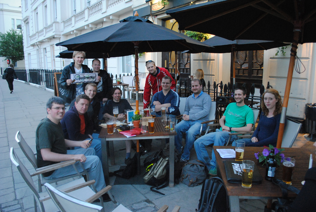
Image of the Week: London Summer Mapping Evenings 2011

Media_httpwikiopenstr_vbdgf

It is no accident that OpenStreetMap was founded in London, and that
the London OpenStreetMap community is so strong, so engaged and so
important to the everyday functioning and long term success of
OpenStreetMap. They meet often, they map often and they are
passionate about OpenStreetMap.

These are the faces behind many of the emails that you see on the OSM
lists, behind the code submissions that improve OSM and behind the
server racks adding another hard drive. Show us your local OSM group.
Add more faces to the OSM emails we read.

This is a Featured image, which means that it has been identified as
one of the best examples of OpenStreetMap mapping, or that it provides
a useful illustration of the OpenStreetMap project.

If you know another image of similar quality, you can nominate it on
Featured image proposals.

http://wiki.openstreetmap.org/wiki/Featured_image_proposals

Project of the Week: Sports centres

May 2011 is sport and activity month. The Project of the Month is to
map sport pitches in your area. Other sport and activity related
objects will be Project of the Week for the remainder of May.

A sports centre caters to several or many individual sports by
providing the infrastructure for participants in those sports. A
racquet sports centre might include playing courts for tennis, squash
and racquetball among others. A general sports centre might include a
multi-purpose gymnasium, outdoor fields for soccer, rugby, football
and baseball and indoor and outdoor courts for volleyball.

This week, we add sports centres to the map.

Sports centre photo by Battle Creek CVB is licensed

Emilie Laffray resignation

Emilie Laffray has resigned from her position as board member and treasurer of the OpenStreetMap Foundation. The board has accepted her resignation with regret and thanks Emilie for all of her work as member of the board.

The board appointed Oliver Kühn to the position of treasurer previously held by Emilie Laffray.

The OpenStreetMap Foundation board will continue with six members until the next board election.

Tile server upgrade

The OpenStreetMap server team has upgraded the tile server to render changes faster. Demand for OpenStreetMap tiles has increased steadily as the project grows. Recent increases in demand for tiles has lead to long waiting times for mappers who want to see the results of their improvements to the map.

Thanks go to Grant Slater, Jon Burgess, the Mapnik.org team, and many others who keep improving OpenStreetMap every day in ways large and small.

Read the announcement and hardware details on talk@.

Speedometer photo by Nathan E Photography is licensed CC-By

Directions (and correcting erroneous routing behavior) with OpenStreetMap

Many people are wondering how they can get directions with OpenStreetMap. Currently, there is no ‘directions feature’ on the website, OSM.org. However, there are methods to get directions based on OpenStreetMap data. Probably the most sophisticated web solution is open.mapquest.com.

Moz-screenshot-1

You can enter a starting point and a destination, either as an address or POI. Alternatively, you can right-click on the map and select a location as a starting point, and a destination respectively. Directions can be optimised for cars, bicycles or pedestrians.

If you want to report a problem with the directions you can do this in MapDust.com or directly in open.mapquest.com. Also, if you want to work on routing problems, MapDust shows you all the reported problems and gives you the opportunity to adjust a route around a problem to see how the map redirects the engine functions around the problem in real-time. More information can be found in the wiki resource.

Moz-screenshot

Update:

There are other tools that might be wortg trying e.g. http://maps.cloudmade.com/ or http://www.openrouteservice.org/

New Changeset display

The OpenStreetMap web site was updated today. When you view the history tab, you’ll now see a map with bounding boxes shown for recent changesets in the area. Hovering over the changeset will highlight the bounding box, and vice-versa.

This improvement was coded by Mikel and refined by Mikel and TomH.

Read more about this from Mikel’s announcement on his blog.