New Tile Render Server in the USA

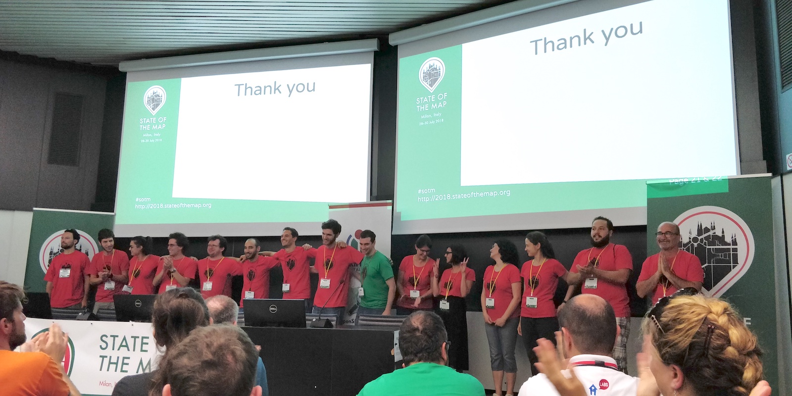
We have a new Tile Render server in the United States! The hardware has been kindly provided by OpenStreetMap US and hosted by the Oregon State University Open Source Lab. Big thanks to them, and to Ian Dees who coordinated this response to the Operation Working Group’s request.

Our distributed tile serving infrastructure brings the “standard” map tiles to your browser wherever you are in the world in a reasonably fast fashion, resulting in a pleasant map viewing experience on the OpenStreetMap.org front page, and with new map edits reflected a few minutes after they are made. It should always be noted that this is far from the only way of using our maps, and we encourage developers to take our data, render it, and otherwise make it available to users in a new ways. However, we do like the front page map to work well. We have a set of “rendering” servers doing the hard work of creating and refreshing raster map tiles, and a larger set of caching servers. With the introduction of a new rendering server in the United States (the first outside of Europe) tiles will load faster. The server itself is fast, and for users in the United States we expect to remove about 100 milliseconds of latency for people viewing the map.

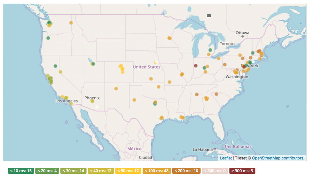
Network latency for requests to the new tile server from various locations in the USA

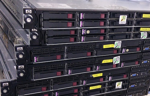
Details of this new server (which we’ve named “Pyrene”) can be found on the hardware.openstreetmap.org site.

We’re still building our tile serving infrastructure, with a lot of help from people and organisations donating resources. If you are in a position to help with this sort of thing, a caching server – or better yet a rendering server – in India would make a huge performance improvement for people there. Learn more about the kind of servers we need at our wiki page and contact the Operations Working Group.

OSM condemns recent anti-semitic vandalism

Earlier today news surfaced of various online maps displaying an anti-semitic term instead of the label “New York”. Unfortunately we have to confirm that this data originated with our editable map project. This vandalism was detected and fixed within 2 hours, and the vandal was blocked from contributing further to OpenStreetMap.

On behalf of our organisation and community, OpenStreetMap condemns this kind of antisemitic hate speech without hesitation. We are disappointed that our project, which is devoted to sharing knowledge, was turned into a vehicle for the expression of ignorance, and hate. How did it happen?

Part of the “Open” of OpenStreetMap, is being openly editable. It is a wiki-style, crowd sourced, collaboration in which users all around the world can contribute and make edits. As with wikis, like Wikipedia, all changes are published immediately, and we put tools into the hands of our community to monitor each other’s changes and revert vandalism. This “soft security” approach may sound surprising, but over the years we’ve found, as something of a triumph of human nature, that the vast majority of editors want to come together to help build something great, and these massively outnumber the few bad apples. OpenStreetMap is a not-for-profit good cause, and the map data is “owned by” the community. On the whole people tend to have respect for that.

In fact this vandalism happened a month ago, but delayed processing of data updates by some companies downstream, in this case Mapbox, which presents our maps to thousands of apps and websites –means that this vandalism was seen quite widely today. Mapbox has posted their response to the incident here. There is on-going work within the OpenStreetMap community to develop better quality assurance tools, to detect and deal with this sort of issue faster. Mapbox has been spearheading these initiatives both in terms of developing vandalism detection software, and committing staff toward the efforts of monitoring and reverting bad edits. Unfortunately human error in their processing pipeline led to this incident in OSM-based maps that Mapbox provides to companies like Snapchat.

If you see vandalism on our map, you can help. Read more about vandalism here. We will continue to work with our community and data consumers to make our map even stronger.

Happy Birthday OpenStreetMap

Cake in Fukushima, Japan © CC-BY-SA 3.0  Ikiya and family

OpenStreetMap is 14 today! We’ve been partying in various locations around the world: Hyderbad, New Delhi, Moscow, Kigoma, Rapperswil, London, Washington DC, Denver, and Seattle.

Celebrations in London

Celebrations in Dhaka, Bangladesh, after a mapathon

If you missed the birthday party, don’t worry. Our community is lively with events happening all the time. You can see some of them listed on the current events list here, or find out more generally what’s happening in your country/city on the wiki.

Cake in Washington DC

The true “Birthday” of OpenStreetMap is lost in the sands of time. Observance of the anniversary of the creation of OpenStreetMap is held on or about the anniversary of the registration of the OpenStreetMap.org domain name (9th August). This year 12th August seemed like a suitable Sunday!

With over a million people making OpenStreetMap edits, and around 5000 people making edits on any particular day, it’s hard to imagine a time when all of this hadn’t even got started yet, But that time was 14 years ago, in the summer of 2004. We’ve come a long way since then. Wherever you are in the world, join us in saying “Happy Birthday OpenStreetMap!”

Winners of the 3rd OpenStreetMap Awards

The OpenStreetMap Awards were held for the 3rd time on 30th of July at the State of the Map conference. Beforehand nominations were provided and shortlisted by community voting, and at the closing session of the conference, the community came together and applauded all the nominees as the winners were revealed (Video of this session)

Ilya Zverev presenting the OSM awards © CC-BY-SA 4.0 OSMF Communication Working Group

There were nine nominations in each of the nine categories. Find out more about each of them on the awards site and on the wiki. All nominees are very deserving of awards, but here are this year’s winners:

  • The Core Systems Award went to Sarah Hoffmann who leads the development of nominatim, the open source search tool.
  • The Innovation Award went to Wikimedia Foundation Collaboration Team who have developed an impressive mapping stack for the Wikimedia projects, including features like the map internationalization.
  • The Influential Writing Award went to Christoph Hormann who has been examining many mapping style choices, enlightening us on satellite imagery processing and generally sharing his opinion on mailing lists and the blog.
  • The Greatness in Mapping Award went to Tshedy The work of Tshedy (Mats’eliso Thobei) is well known in the OSM Community. She is popularly known as “Lesotho Mapping Queen”. She is an avid writer, trainer, and mapper.
  • The Expanding the Community Award went to Christine Karch. Christine who is a part of the State of the Map Working group has contributed in expanding both the developer and the general OSM Community worldwide through hack weekends and other events.
  • The Improving the Latin America Award went to Natalia da Silveira Arruda, a professor at the University of Antioquia (UdeA) who runs a Youthmappers chapter at the University in the city of Cartagena de Indias/ Colombia. So far this has trained >200 students.
  • The Improving the Africa Award went to Crowd2Map Tanzania, a volunteer-run mapping project that unites over 2000 remote mappers worldwide with over 600 community mappers on the ground in Tanzania. Since 2015, they have mapped schools, hospitals, roads, buildings and villages across rural Tanzania.
  • The Improving the Asia Award went to State of the Map Asia 2017 organizing team who successfully brought 200 open mapping enthusiasts from Asia and beyond to this conference held in Nepal.
  • The Ulf Möller Memorial Award went to Richard Fairhurst. He is a longstanding shining light of the OpenStreetMap community, and developer of key software such as the Potlach editor, an entry point to OpenStreetMap for many.

We congratulate all the award winners and everyone else whose hours and hours of contribution have made OpenStreetMap the map it is! Finally thanks to Ilya Zverev for his hard work in running the awards, and thanks to all those who nominated and voted. Please continue the good work, and prepare to nominate each other for the next year’s awards!

SotM Milan – Thanks for coming!

With over 420 attendees from 54 different countries, the OpenStreetMap community came together in Milan, Italy, for another fantastic annual State Of The Map conference at the weekend. Thank you to everyone who made it to Milan.

…and of course a big thank you to the organising team for putting so much work into making the conference the huge success it was. The SOTM organizing committee is composed of the international organisers: Benoit Fournier, Christine Karch, Gregory Marler, Mikel Maron, Rob Nickerson, & Michael Reichert and the local team in Italy: Alessandro Palmas, Alessandro Saretta, Francesca Ussani, Marco Minghini, Maria Antonia Brovelli, Maurizio Napolitano & Michael Montani, and a wider team of volunteers who joined in to help the event run smoothly. Thank you all!

Some of the local SotM volunteers and organisers on stage at the closing session

Videos are already available in unedited form, for the two main conference rooms across the three days:

Finally thanks to the conference sponsors:

bing, facebook, mapbox, Telenav, immobiliare.it
Garmin, Kaart, mapillary, maps.me, OSMAnd

There’s lots to talk about from the conference, including several other announcements which will be coming soon here!

Server moves: Goodbye Imperial. Hello Equinix Amsterdam

Servers de-racked and ready to move

Some of our servers are moving to a new home. Quite a few of our important servers have been housed at Imperial College in London for the past few years, but it’s time to move on from there as they look to reclaim some space for offices. We’d like to thank Imperial for our time together!

We continue to be thankful to University College London, and Bytemark who are still generously providing hosting for some other keys servers, not to mention our many Tile Cache hosts around the world. If you’re interested in server details you can see the full list on our hardware page.

That list is set to change very soon, as Imperial machines are powered down and moved. The move is being carried out this week by volunteers from the OWG/OSMF.

Where are we moving these servers to? We sought proposals for a new home (thanks to all those who replied), and Equinix Amsterdam has been selected as our new data centre provider. This brings a little more diversity of locations for our servers (many of the others being in the UK), but it’s still not a million miles away, in case our operations team need to visit. Equinix Amsterdam provide excellent “smart hands”, removing the need for physical visits on a regular basis. That being said, the Operations Working Group are seeking someone to help in Amsterdam who can visit the data centre if we need. To quote the OWG folks this volunteer would “need to be trusted, competent and did I say trusted”!

As ever, we owe a big thanks to OWG volunteers for all the hard work going into managing these server moves.

Making the most of State of the Map

Photo CC-BY-NC Mariano Mantel

There is a great program of talks and workshops for this year’s State of the Map, but as people gather from around the world we want to help you make the most of this in-person time together.

Travel tips

To help you travel stress free we have added useful info to our website. For example, once in Milan, the easiest way to get to State of the Map is to take the M2 (green) subway line to Piola.

Flying in to Malpensa Airport? Buying tickets online saves money only if you buy a Malpensa Express Return Ticket 30 Days – you pay 20€ instead of 26€. The departure and the return journeys can be made within 3 hours of the time of train you select and the ticket is sent to an email address.

View the attendee list

OpenStreetMap communities form an integral part of OpenStreetMap. We interact online throughout the year but seldom have an opportunity to meet those that live far from us. As we come together at State of the Map we have made the attendee list available to help you make connections, meet old friends and form new ones.

Run a session

Check out the program for this year’s selection of talks. Perhaps something new has happened since the deadline for proposing talks, perhaps you didn’t have the idea quite worked out.

Throughout the 3 days we have spare rooms for you to host a break out session (Birds of a feather session). And on Monday we have some extra Lightning Talk slots available. These are quick five-minute talks that don’t need to have slides.

You can sign up for both by visiting the registration desk at State of the Map. Keep an eye on the board to see what other people have added; you wouldn’t want to miss something amazing!

Join in from home

Not able to attend this year’s State of the Map? We will be live streaming the main rooms throughout the event. Keep an eye on our website for the links.

You can also follow us on Twitter @sotm and use the hashtag #sotm. And new this year, we have created a telegram group for the conference. Join us here.

Your State of the Map team

Bing Streetside imagery now available in OpenStreetMap iD editor

Interactive Bing Streetside viewer embedded in the iD editor © CC-BY-SA

We are excited to announce that you can now use Bing Streetside photographs when you edit OpenStreetMap using the web-based editor iD! This is the same imagery currently visible on Bing Maps. You can activate the Bing Streetside layer in iD by opening the Map Data pane (shortcut F). The new layer provides 360-degree panoramic imagery across large regions of the United States, United Kingdom, France, and Spain. The massive imagery dataset covers approximately 1.6 million kilometers and takes nearly 5PB of storage! Thank you, Microsoft.

Go on – try it!

Other street-level imagery datasets in iD
This street-level imagery dataset in an addition to the existing ones provided in iD by OpenStreetCam and Mapillary, which you can also activate by opening the Map Data pane (shortcut F).

If you find street photography helpful for OpenStreetMap editing, you can also contribute your own photographs, using the Mapillary and OpenStreetCam smartphone applications. These are developed by companies independent from the OpenStreetMap Foundation.

A reminder about photomapping
Are you a new mapper excited about photomapping? Please remember that on-the-ground survey is always superior, as photographs represent a specific time snapshot. Feel free to improve the map using photographs, just keep in mind that the photos might be old. Before changing someone else’s edits, consider contacting the mapper first.

Street-level imagery in other OSM editors
Street-level photographs are also available for improving the map in other popular OpenStreetMap editors, such as JOSM. The Bing Streetside imagery will probably become available in some of these editors soon, so stay tuned!

Happy mapping!

About iD
The iD map editor is an open source project. You can submit bug reports, help out, or learn more by visiting the project page on GitHub.

Switching to OpenStreetMap!

More and more people and organisations are considering switching to the OpenStreetMap platform for displaying and processing geographic data. There are various reasons why one might like to switch:

Why switch

OpenStreetMap provides open geodata freely to all

Our licence says that you can always copy and modify our data for free.
Your obligations are:

  • Attribution. You must credit OpenStreetMap with the same prominence that would be expected if you were using a commercial provider.
  • Share-Alike. When you use any adapted version of OSM’s map data, or produced works derived from it, you must also offer that adapted data under the ODbL.
    See OSM’s copyright guidelines.

You can make the maps that suit you

With OpenStreetMap, you’re in control. Turning the data into rendered maps can be done any way you like. Want to emphasise cycle routes and play down motorways? No problem (Most other maps don’t even have cycle routes). Want to label subway stops but ignore bus stops? Easy.

Rich, accurate, up-to-date map data

  • Rich: OpenStreetMap might have “street” in the name, but we do much more. Natural features, bus routes, footpaths and cycleways, administrative boundaries, shops, rivers and canals, benches… you name it. See some of our map features (there are more than those listed).
  • Up-to-date: Data on www.openstreetmap.org is constantly updated, and you can get those updates every day, every hour or even every minute if you want.

All this is contributed by our volunteers (over 1,000,000 contributors so far, and growing every day) – the people who really know about their area.

It’s easier than you think

There’s no limit to what you can do with OpenStreetMap. Yet it needn’t take long to get started. You can switch to OSM in under an hour using tools like the easy Leaflet API. Head over to switch2osm.org to find out what possibilities there are.

I want to use OpenStreetMap data

Sure. Read on at using OpenStreetMap.

Can I deploy my own slippy map?

Yes. A slippy map shows map tiles on your web page by using JavaScript code. Please read deploying your own slippy map. Apart from raster tiles there is also the possibility to display a map with vector tiles.

Any advice on using OSM tiles?

Apart from very limited testing purposes, you should not use the tiles supplied by OpenStreetMap.org itself (Tile usage policy). OpenStreetMap is a volunteer-run non-profit body and cannot supply tiles for large-scale commercial use. Rather, you should generate your own tiles or use a third party provider that makes tiles from OSM data.

Docker image

People that would like to self-host may also consider using a docker image (example).

I would like to use the OSM editing API or Nominatim

Please read our

What is considered heavy usage?

If your usage is in any way mission critical for you, you should consider hosting yourself (or paying someone to host for you).

I would like to ask some questions

Sure, go ahead!

  • There is a Q&A platform where your questions might have been already asked and answered. Feel free to ask new ones.
  • We have a forum where there is a dedicated Development subforum.
  • There is a developer mailing list.
  • If you need to reach our Operations Working Group, please note that they are all volunteers and very busy.

I have switched to OSM!

Welcome to our community!

  • We would love if you spread the word about your switch (#switch2osm) on your favourite social media.
  • You can add new OSM-based map services to this list (not for personal websites but map services).

I would like to help!

Great! There are various ways you can help the project.


Sources: switch2osm.org wiki.openstreetmap.org osmuk.org/pinned/reduce-costs-switch-openstreetmap

Check in to State of the Map 2018

State of the Map is all about the coming together of the OpenStreetMap community but this doesn’t have to be limited to the conference venue. Working with our travel partner (they also do our scholarship travel and – free of charge – arranged the venue for the social event), we have rooms set aside at two major hotels just for State of the Map attendees. Rooms cannot be held indefinitely so please book at the earliest possible opportunity to avoid disappointment.

Please use the below link to reserve your room.

For any queries relating to accommodation, please contact Gwen Manac’h on +442079027760 or gwen.manach@gdg.travel.