Head over the State of the Map 2008 site to register for this year’s OpenStreetMap conference – sign-up before the 6th May to get an early bird discount.
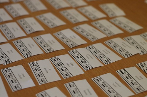
Head over the State of the Map 2008 site to register for this year’s OpenStreetMap conference – sign-up before the 6th May to get an early bird discount.
Commercial map providers have for years used ‘easter eggs’ or as cartographers know them ‘trap streets’. These are fake streets, churches and sometimes villages in maps that are put in on purpose. If you copy the map then the map owner knows it was you because you couldn’t possibly have mapped these fake features.
OSM has a large wiki page on the subject including this picture of an A-Z map:

Notice ‘Lye Close’ ? This pun has been put there as a trap street, there is no actual street there.
In the license process, the OpenStreetMap Foundation has recognised the need for a license not just based in copyright law. Like large commercial map suppliers we are moving toward a license based upon copyright, database and contract law. These ‘three pillars’ are the same foundations upon which many data sets are sold.
Similarly and in order to professionalise OpenStreetMap due to the increasing completeness and therefore value of the OpenStreetMap data we need to protect copyright. The OpenStreetMap Foundation has decided to begin a process of entering trap streets in to our data. These will be in out of the way places so that they are not noticed, but if that data turns up in a TomTom or similar device then we will be able to prosecute for infringing our data.
This process was decided on secretly at the first OSMF board meeting over a year ago and many hundreds of trap streets are now present. The OSMF has decided to go public now because we have completed an entire ‘fake village’ and placed it in southern Germany. These trap streets and the trap village are un-deletable in the API due to special code to protect copyright.
The OpenStreetMap Foundation Board feel this is a good compromise between on the one hand having only real streets and no copyright protection and on the other enforcing all downloads of data with DRM mechanisms which were found impractical. The community impact is now to be measured, now that these methods and tools are public.
The Board would like to invite discussion on this exciting new method of protection, and will follow comments to this post closely.
The OpenStreetMap Foundation Board.
Heathrow terminal 5 opened today. With a capacity of 30 million passengers a year (representing an estimated 50,000 car journeys per day), and having been under construction for over five years, you would expect it to be clearly marked on all the leading on-line maps.
So lets have a look at the state of Terminal 5:
Google Maps

Hmmm… no sign of Terminal 5. OK, the new junction from the M25 is shown and half of the spur road, but then it incorrectly becomes an ordinary road. And where T5 should be the old sewage farm access roads are still showing. Really, if you look at Google Maps there’s not much of a clue where T5 is likely to be.
Microsoft
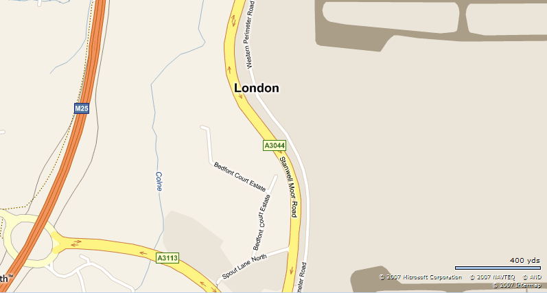
So what about maps.live.com? No sign of T5, no new motorway spur road. Nothing.
Multimap
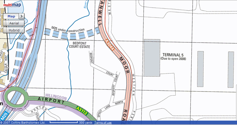
Now we are getting somewhere. The T5 terminal building is shown and the satellite T5B building. But wait! So is T5C which hasn’t been built yet. Maybe they are getting a bit ahead of themselves.
Well, maybe not, the M25 access road is still shown as under construction (even though it’s been in use by local taxi drivers for over a year) and no it doesn’t connect to Stanwell Moor Road. Oh, and if you zoom out too far T5 disappears, the link road loses it’s motorway status and the old sewage farm access roads re-appear. Oh dear.
Streetmap
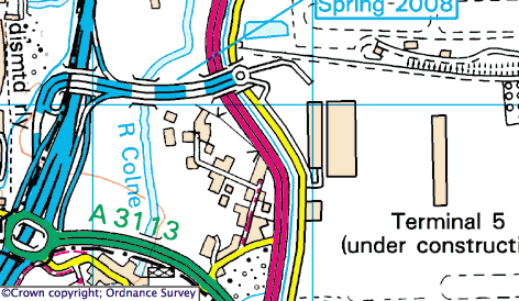
Streetmap looks promising. T5 and T5B are shown, but marked as under construction. T5C is not shown; extra marks for getting that right. The motorway spur road is shown correctly terminating at a roundabout, and the access roads into the terminal are show as stubs. Almost full marks so far. Zoom in a bit… oh dear, the motorway spur now terminates incorrectly at Stanwell Moor Road, all the local access roads are gone, and T5C suddenly appears. Arrgh.
Mapquest

Sigh.
BAA
British Airports Authority are the owners of Heathrow Airport. Surely their web-site will have a decent map.
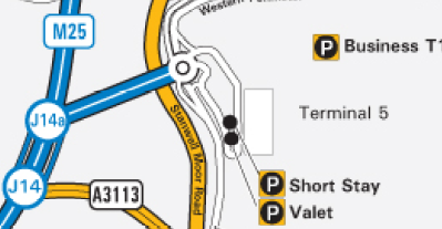
Umm… no. They show terminal 5 as being reached via junction 14A. Sorry guys, there is no junction 14A. And where’s Whittle Road, the access road from the Western Perimeter Road into the southern end of the terminal building? And don’t you remember constructing T5B? Well at least you’ve marked some car parks.
The AA
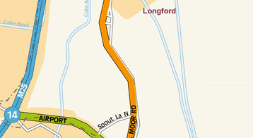
Just don’t expect the Automobile Association to help you find it.
OpenStreetMap
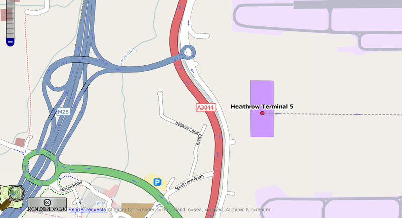
And finally, lets look at our own efforts in OpenStreetMap. The M25 spur road and the main terminal building are both shown. The local access roads are just stubs, but that’s understandable as there’s been no public access past these points until today. As a bonus the Piccadilly tube line is also shown. It’s not quite perfect though. The roundabout at the end of the spur road is marked as having motorway status, which it doesn’t, the T5B satellite building is not shown, and nor are any car parks.
Searching
Trying to locate terminal 5 using each map’s search facility produces equally disappointing results. I tried the search term “Heathrow Terminal 5” in each one:
Heathrow’s terminal 5 is a major high profile new development. On it’s own it is bigger than any other airport in Europe except Frankfurt. It will generate, from today, more car journeys than a decent sized town. Yet most of the on-line mapping sites don’t seem to be capable of having a decent map ready on the day that it opens.
It’s examples like this that demonstrate how well OpenStreetMap can produce accurate and timely maps. Further vindication of the effectiveness of the OpenStreetMap approach.
When we started to hear stories about OSMers in far flung corners of the world begging and borrowing equipment in order to help OpenStreetMap, the OSM Foundation wondered what it could do to help.
Well, after a protracted gestation period we are pleased to announce the GPStogo scheme. Its quite simple. We collect small donations from our supporters in wealthy countries, use the money to buy GPS receivers, and loan them to enthusiastic but poorly equipped OSMers in developing countries.
There’s full details of the scheme on the brand new OSM Foundation web-site.
We already have some promises of donations and a (short) list of worthy recipients, so the pumps are primed.
Our initial goal is to purchase one GPS receiver a month and ship it out to whoever is next on our list of qualified loan applicants.
All we are asking is for OSMers to donate a fiver a month to support this scheme. You’ll get lots of kudos and have the satisfaction of seeing map data appearing in some of the more distant corners of the planet. Sign up here.
And if you are a GPS-less budding OSMer in a developing country then please get in touch, we need to know what you need to be able to go out mapping. Let us know here.
We’ve been selected to mentor students this year. We have about six potential mentors so far, and now we need some students. If you are a student, or teach students, or know either teachers or students, and think they’d be good match for OpenStreetMap in the Summer of Code, encourage them to look through our projects, get in touch with us, and apply next week.
Many many thanks go to Spaetz for putting together our application.

The State of the Map 2008 international OpenStreetMap conference website and blog is now live and the call for participation/papers has gone out. Speaker slots are limited and like last year are bound to fill up quickly, so send us your abstracts!
The conference is being held at the Kilmurry Lodge Hotel in Limerick, Republic of Ireland on 12th and 13th July 2008.
It’s been pointed out a couple of times that the Foundation hasn’t been super public in its activities. In some cases it just can’t be, say if it’s secretly negotiating a data donation or something but for the most part we can waffle on about our achievements. So what have we been doing? We have monthly phone board meetings which last 2-3 hours to go over everything. A lot of it is fairly mundane like responding to communications but others take somewhat more work, things like:
Your friendly foundation board is available to help on these things and more.