
On her twitter feed, moment ago, Thea Clay announced that she was
leaving CloudMade.
On her twitter feed, moment ago, Thea Clay announced that she was
leaving CloudMade.
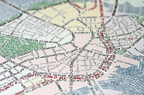
I’m not entirely sure what axismaps.com does but it sure seems to
involve a lot of pretty maps. This caught my attention when pointed
out to me by OSM contributor RichardF.
These unique maps of Chicago and Boston accurately depict
the streets and highways, parks, neighborhoods, coastlines, and
physical features of the city using nothing but type. Only by manually
weaving together thousands upon thousands of carefully placed words
does the full picture of the city emerge. Prints are
available.
So, Boston and Chicago, but I’m told that San Francisco, New York and
Washington are in progress, too.
See more pretty maps and wonderful photography of maps on their web site.
http://www.axismaps.com/typographic.php
They have a blog entry describing the process of creating these maps, as well.
http://www.axismaps.com/blog/2010/09/typographic-map-posters/
OpenStreetMap Foundation Board member, Oliver Kühn, interviewed Jack
Dangermond, today at INTERGEO 2010 in Cologne, Germany.
[vimeo http://www.vimeo.com/15607795 w=500&h=283]
INTERGEO conference

They are the literal markers along a way; we can go three blocks then
turn north. Crossroads are also the metaphorical points of decision in
our lives; we can come to a fork in the road in deciding between two
job offers. Crossroads are all about decisions; left or right; hold,
raise or fold; ketchup or mustard. This week we map our decisions.
Feel free to map your literal or metaphorical crossroads.
Details and suggestions on the Project of the Week wiki page
http://wiki.openstreetmap.org/w/index.php?title=Project_of_the_week/2010/Oct_06
This is your Project of the Week. Submit your own projects or offer
suggestions.
http://wiki.openstreetmap.org/wiki/Project_of_the_week/Proposals
Signpost photo by Matt Brown
http://www.flickr.com/photos/londonmatt/
Licensed CC-By-SA
http://creativecommons.org/licenses/by/2.0/deed.en_CA
Mikel Maron has resigned his position of Chair of the Data Working
Group at OpenStreetMap Foundation. The Data Working Group assists OSM
contributors in matters of vandalism, copyright violation, editing
disputes and data policy. Mikel has served as Chair since the
formation of the DWG. OSMF Board thank Mikel for his service on DWG
and his continued service on OSMF Board. See Mikel’s announcement on
the OSMF Blog.
http://blog.osmfoundation.org/2010/10/06/mikel-maron-steps-down-from-dwg-chair/
In an email to the OSMF Board, on 06 October 2010, Mikel resigned from his post as Chair of the Data Working Group.
Data
I am resigning from the Chair of the DWG. My time commitments with other Foundation duties, Kibera, and HOT, are already more than full time. Steve has generously offered to take the helm from here.
Thanks everyone for the extremely hard work over the past 2+ years. I first became interested in these issues with the edit war in Cyprus, and we’ve gone very far in defining how the Foundation, reluctantly, gets involved in copyright, vandalism, and conflicts. Fortunately, OSM has been much less plagued by these issues than we might have imagined. Anyone can do whatever they want in OSM, and it turns out most everyone cares deeply about making the map the best map out there.
There’s still lots of work for the group to do, especially in widening participation in the group to ease the work load, effectively communicating the procedures, defining the limits of community license enforcement, and getting OTRS fully operational. Thanks again for keeping up with this work, and much thanks for Steve for stepping up.
Best
Mikel
The OSMF Board thank Mikel for his service as Chair since the founding of the Data Working Group and for his continued service on the board.
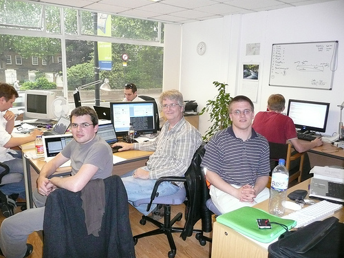
OSM founder, CloudMade co-founder and founder of OpenGeoData, Steve
Coast has resigned from CloudMade. Announced moments ago on his blog,
Steve said, in part:
I’d like to thank everyone I worked with in any capacity
at CloudMade, and I wish CloudMade, it’s employees, investors Sunstone
& Greylock and it’s operating companies Progression Partners &
Cogniance all the best in the future and I will continue to support
the company as a shareholder.As for me, I’ll be taking some time off to think about the future and
perhaps get some more hangliding in.
But you should really read his full announcement.
I’m envious of his hangliding opportunities and we all know that
whatever is next on Steve’s list will be Fantastic.
http://blog.stevecoast.com/ive-resigned-from-cloudmade
I wish you “good lift” my friend.
Photo of the former CloudMade team by Shaun McDonald
http://www.flickr.com/photos/smsm1/
is licensed cc-nc-sa
http://creativecommons.org/licenses/by-nc-sa/2.0/deed.en_CA

Jochen Topf has announced his latest project. It is a tool to explore
the OSM database, inspired by Tagwatch, Taginfo and OSMdoc. This is a
nice addition to the tools we use to check and improve OpenStreetMap
data quality. His announcement, in part, reads:
For the last months I have been working on a software called Taginfo that
brings together information about OSM tags from the OSM database, the wiki
and other places. Somewhat like Tagwatch, Tagstat, and OSMdoc, but more
ambitious. 🙂I am happy to announce that the beast is now available at
http://taginfo.openstreetmap.de
There are still some bugs and lots of missing features, but its already
usable. Updates are currently done manually, but I will do automatic daily
updates soon.
More details and background in Jochen’s blog entry at:
http://blog.jochentopf.com/2010-10-05-introducing-taginfo.html
He’s made taginfo entirely Free Software / Open Source. You can find
the Taginfo code, under GPL v2 at github:

Mapping Party Marburg, Germany, 28.2.2010. Blind and seeing mappers
discover a tactile model of the Elisabethkirche.
See the full size image here.

This is a Featured image, which means that it has been identified as
one of the best examples of OpenStreetMap mapping, or that it provides
a useful illustration of the OpenStreetMap project.
If you know another image of similar quality, you can nominate it at
I want to give a shoutout to usabilla.com who’re helping OpenStreetMap with visual feedback on our user experience testing and design.