The map you see on OpenStreetMap.org is changing

If you head over to OpenStreetMap.org and click on the layers button on the right of the map, you are provided a selection of map layers to choose from. This is possible due to the nature of OpenStreetMap – by distributing open geographic data we enable others to produce a map from OpenStreetMap data in whatever style they require. The OSM website provides five such styles but there are many hundreds, if not thousands of other styles in use across the web.

We will shortly begin to roll out a new version of the ‘Standard’ (or default) map style replacing the current version. Although the new version is an evolution of the existing version, the changes to road colours and the display of railways will significantly help to improve the readability of the map. During this roll out you may see a patchwork of old and new map style for a few hours – please be patient whilst our servers work hard to update all corners of the map.

before-after road styles

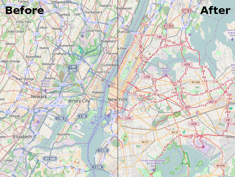
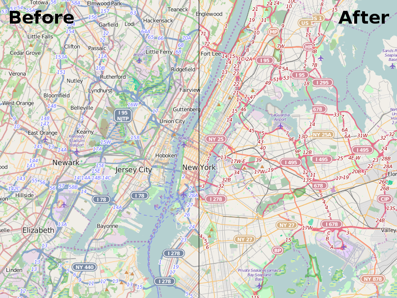
How will the style change?

The change of the map style will primarily effect the way roads and railways are displayed. As OpenStreetMap has grown over the last 11 years we have began to collect more and more information about our surrounding environment. The standard map style has adapted to display this information, but over time this has led to the road and rail network becoming harder to identify. For example, trunk roads (currently shown in green) can be very hard to see in heavily forested areas.

In the new map style “road colours [are] tuned to ensure that roads are well visible on all landcovers”, explains Mateusz Konieczny, who has developed the new style (project details) . Mateusz has worked with the OpenStreetMap community at every step of the journey from initial research to draft implementations to gather feedback on the design. He adds that “steady progression of hue and lightness for major road types (motorway, trunk, primary, secondary, tertiary) should make more intuitive which roads are more important”.

There’s been other recent changes to the style – why highlight this one?

You’re right. For the last few years there has been a new map style released every two to three weeks. As with all things OpenStreetMap there is an army of volunteers working to fix and improve the map style. It would be great to write about all of them but that’s simply not possible. So this change, being one of the larger ones and a Google Summer of Code project, gives us a great opportunity to pause and thank all those who have contributed to the map style. Thank you style maintainers!

What next for this map style?

In the short term, it’s likely to be small incremental tweaks so as to continuously improve the map. Every big change attracts new style maintainers who bring their own ideas and experience. There may be a few minor tweaks to the paths and roads based on their ideas.

There is also an updated version of Mapnik, the underlying toolkit used to convert the written style rules in to the final map you see on the OSM website. The latest version will help to fix a lot of bugs related to non-latin scripts/languages. In the longer term there is the option to repopulate the database used by the Standard map style so that it has access to all OpenStreetMap data tags, not just a limited few.

Can I help with development of the ‘Standard’ style?

Yes. The standard map style, which is known as OpenStreetMap-Carto is available on GitHub. Andy Allan, who re-energized the development of this map style in 2012 has given a number of talks at recent OpenStreetMap conferences. Two good starting points are his talk at State of the Map US 2015 in which he gave a progress update for the project, and the detailed workshop he ran at State of the Map EU 2014.

And what about the other map styles?

Well this change only affects the ‘Standard’ (or default) layer as seen on openstreetmap.org.
There are a number of alternative map styles available or you could make your own. Perhaps you want to produce your own personal map to highlight features that are important to you, or maybe you want the map to better match your company brand. This is all possible with OpenStreetMap data. You can even take the current ‘Standard’ as a starting point.

Is it possible to add new map styles to the OSM website?

It is possible, although your style (and the hosting of it) must meet a number of criteria to be considered. See our tile layer guidelines.

New OpenStreetMap US board + Upcoming foundation elections


OpenStreetMap US ran a board election process recently, and yesterday they announced their newly elected board members. Congratulations to Ian Dees, Alex Barth, Alyssa Wright, Martijn van Exel, and Drishtie Patel! The run up to the election included this recorded video conference featuring the candidates, which seems like a great way to get to know the personalities involved. If you’re based in the U.S. be sure to get involved in this local OpenStreetMap organisation: openstreetamp.us

The OpenStreetMap Foundation (the organisation supporting OpenStreetMap globally) is also kicking off a board election process. The election will take place in December, so now is a good time to join the foundation if you are not already a member. This is a great way to support OpenStreetmap, and the osmf-talk mailing list will bring you updates on how the board elections will work. Read more on the election wiki page where we are also inviting new board candidates to step forwards.

Birthday and hack weekend

Last weekend OpenStreetMap turned 11 years old, and we celebrated the birthday in Passau, Fukushima, Moscow, Chennai, Taipei, Bengaluru, Beijing, Zurich and London!

The 11th birthday cake arriving for the party in Bengaluru

The 11th birthday cake arriving for the party in Bengaluru

In London this coincided with the OpenStreetMap hack weekend event. Developers came together to do technical work on OpenStreetMap, this time with a “mobile” theme. You can read more about the event on the wiki. Thanks to Rob Nickerson who listed out the various things we worked on. He visited from Birmingham, and then wrote it up on the OSM birmingham blog. We even had a write up on the Ordnance Survey blog, because the event was hosted at the ordance survey “Geovation Hub“. A fantastic venue! We hope to be back there some time, and we hope to see more collaboration between OpenStreetMap and the UK national mapping agency. Also thanks for the pizzas PIE mapping.

Of course technical developments in and around OpenStreetMap are taking place all the time all over the world. These include external applications such as mobile apps, and improvements to more core components. Just today Paul Norman released osm2pgsql version 0.88.1 for example. Several of our contact channels are dedicated to development work, and the engineering working group are keen to find ways of getting more developers involved.

So if you missed the hack weekend or you missed out on the birthday cake, don’t dispair! There’s lots of ways to get involved in OpenStreetMap.

Target reached – Thank you!

Today we’ve reached our fund-raising target: £56,000 !

thank-you-restaurantosm.org/go/ZUfMByg0Z

The Operations Working Group set out their detailed plans for the server upgrades they’d like to do: A big new database server, new tile servers and an imagery server. Thanks to your generosity, we now have the funds in place to make that a reality.

This has been our largest fund-raising target, but given the scale, reach and impact of OpenStreetMap, £56,000 is a small amount of money. For the thousands of data consumers, and millions of map end-users viewing OpenStreetMap, or the mega-corporations our maps are compared against. Don’t we deserve more? Lots of interesting discussions around this topic, but I will just say for now… Yes we do! And of course you’re very welcome to donate more:  donate.openstreetmap.org

The OpenStreetMap Foundation remains open for donations. If you have ideas on how to get more recognition and big donations for OpenStreetMap, this is always welcome too!

For now though, we want to say a big Thank You again to Mapzen and Mapbox who made big donations to kick things off, to various other organisations who made donations to support us, and to all the individuals (more than 1200 of them!) who generously chose to put their personal money towards the OpenStreetMap cause.

Announcing SotM 2016

We are delighted to announce that State of the Map 2016 will be held in Brussels, Belgium.

Thank you to all teams who submitted a proposal. The quality of the bids was fantastic and it was a pleasure reviewing them.

We are very much looking forward to working with the Brussels team to organise a successful State of the Map 2016. See you in 2016 in Brussels!

For more info please follow stateofthemap.org

Events in 2015

Can’t wait till 2016? There are a number of upcoming OSM-centered conferences in 2015, including SotM-LatAm in Chile in September, and SotM-Scotland in October. There are also many webinars, mapping parties, coding events and socials planned for 2015.

In what is turning out to be a busy 2015, these follow earlier events: SotM-FR in Brest, France; SotM-US at the UN’s New York headquarters in New York City; and HOT Summit in Washington DC.

All these events are organised by the wider OpenStreetMap community. Thanks go to the relevant organising teams for hosting these events.

— The photo “Brussels great market square” by ijsendoorn is licensed under CC BY 2.0

Announcing the first SotM LatAm

After the success of the global State of the Map 2014 conference realized last November in Buenos Aires, the Latin America OpenStreetMap community is organizing its first continental conference.
SotM LatAm

The State of the Map Latin America will take place in Santiago, Chile, on September 4th, 5th and 6th. The conference will gather the Latin American and global mappers to share community and  entrepreneurial knowledge, techniques and experiences in OpenStreetMap. The official languages for the event are Spanish and Portuguese, with some talks in English as well.

Santiago is the capital of Chile, its financial heart and biggest city,  concentrating approximately 35% of the population of the country (6.5  million people). The event will take place on the days before the AbreLatam (September 7-8) and ConDatos (September 9-10), two of the biggest Open Data conferences in Latin America.

You can already register for the conference and submit a talk proposal on the website: http://sotm.openstreetmap.cl/

The SOTM LatAm is organized by the Fundación OpenStreetMap Chile.

£36k raised, £20k to go

We’re seeing a steady flow of donations large and small coming in. At £36,052 we’re well over half way to our fund-raising goal. A big thanks to Mapzen and Mapbox who kicked off in style, each with a donation of US$20,000!

MapboxMapzen

With awareness spreading quickly now, we’ve doubled the number of people donating just in the past 24 hours! Each supporter can choose to be named on the donations page, and leave a message to us, so if you didn’t do so already, make a donation now!

Find out all about the server funding drive and donate on:

donate.openstreetmap.org

Don’t forget you can also support OpenStreetMap by becoming a member: as an individual or as a corporation.

Fundraising drive 2015

It’s upgrade time! OpenStreetMap is growing, servers are projected to hit capacity by mid 2015. OpenStreetMap is a global community of dedicated and resourceful people, giving their time to make the best map of the world. Those mappers’ contributions are the largest part of the project. However, contributors need infrastructure such as a repository to share their contributions and services that help them make the map and talk to each other. We are raising funds to keep these services running and improve them, so that everyone else can continue making an amazing map.
support-openstreetmap-2015


The Operations Working Group of the OpenStreetMap Foundation manage the core servers of OpenStreetMap and plan server upgrades to scale for our growing community. They make purchasing decisions around server hardware with the budget they have available. With your help, we can continue to grow the OpenStreetMap infrastructure to support the growth of the community and map. See the FAQ for some answers to frequently-asked questions, or get in touch to start a discussion.

MapzenMapboxUpdate: 36k Raised. 20k to go: Big thanks to Mapbox and Mapzen who kicked off the donations each with $20,000!

What else can we do to support OpenStreetMap?

Join us! Aside from funds to upgrade our hardware what we need most are people. Whatever your background – technical or not – you can help OpenStreetMap. Here are just a few of the many possible ways to get more involved:

For individuals:

If you have contributed data to OpenStreetMap, or time to helping organise mapping activities: thank you for everything you’ve already done!
OpenStreetMap only survives because of the work put in by thousands of hard-working and selfless volunteer contributors. If you are one of these people, then you are already doing a great thing for the project.

If you would like to do more, then you can:

  • Join the Foundation and support the body which supports (but doesn’t control) the project. By being a part of the Foundation, your voice can be heard in discussions about how the Foundation is run.
  • Join a Working Group and give your time to solving those issues which require greater commitment. Being on a Working Group, as the name suggests, is hard work and requires diligence, but can make a huge difference to the project.
  • Donate money to the hardware funding drive. Whatever you can spare will be gratefully received and put towards hardware which is necessary for the continued growth and success of the project.

For companies:

Whether you use OpenStreetMap data in your products and services, or are just interested in helping, corporate sponsorship of OpenStreetMap events and hardware helps the project to keep going and be inclusive.

If your company would like to help the project grow and succeed, then you can:

  • Join the Foundation as a corporate member. Your support of the Foundation will be greatly appreciated and publicly lauded.
  • Donate time. Some of your employees might jump at the chance to be more involved with OSM, so why not give them a “20% time” to join a Working Group or contribute time to a project which helps OSM?
  • Donate money to the hardware funding drive. Any contribution will help and is gratefully received.

Corporate Members: Growing Support

Since we reported about the first corporate members joining the OSM Foundation, we have been able to double the number of our members, and welcome Mobile Interactive from Saudi Arabia, maps.me from Russia, Dabeeo from South Korea, Zoho from India, and Siemens from Germany.

Thank you all for supporting our work at the OSM Foundation.

Is your organisation or business using OpenStreetMap? Consider becoming a corporate member today!

OpenStreetMap tile CDN continues to grow

Since the last additions to our OpenStreetMap tile serving network in December, there has been a lot more server set-up going on.

osm-cdn-2015-03The German tile cache server tabaluga is now retired and is no longer serving tiles. This may sound like bad news, but quite the opposite! Tabaluga has been replaced with a new server, katie, which has taken over its job.
The new tile cache server katie is still located in Falkenstein, Germany, and still hosted by Hetzner.

More good news: There are two tile cache servers in Germany now!
The second tile cache server, konqi, is located in Jena, Germany, hosted by EUserv.

The Russian tile cache server gorynych just had a memory and SSD upgrade, and with this it can deliver even more content.

There is another new server in Hungary. With this Hungary becomes one of 12 countries hosting OSM CDN servers.

Tile cache server sarkany is located in Budapest, Hungary, hosted by szerverem.hu.

With all of these, the CDN (Content Delivery Network) server count comes to 16 active servers.

Tabaluga was running, thanks to Freerk Ohling, at Hetzner since May 2013, and served its last tiles in January. Freerk approached us back in April 2013 to suggest we implement EDNS client subnet support (implemented in December 2014) and to offer us a sponsored tile cache server. Now he has also kindly sponsored new tile cache servers in Germany.

Tabaluga primarily served traffic to visitors from Germany. Approximately 56 million map tiles per day. (avg 652/sec, peaking at 1245/sec). Serving close to 1TB of data per day. It was the highest traffic OSM tile cache server.

OpenStreetMap tiles are free for everyone to use, but should be used with moderation. If you are a high traffic site you should look at switch2osm.org to find out how to use the data and keep the tiles available for everyone.

The OpenStreetMap Foundation seeks additional distributed tile servers. If your organisation would like to donate a tile server and hosting, please see the Tile CDN requirements page on the wiki. You can also support OpenStreetMap by donating to the OpenStreetMap Foundation.

The OpenStreetMap Foundation is a not-for-profit organisation, formed in the UK to support the OpenStreetMap Project. It is dedicated to encouraging the growth, development and distribution of free geospatial data for anyone to use and share. The OpenStreetMap Foundation owns and maintains the infrastructure of the OpenStreetMap project.