Its official. As of Sunday 7th Oct 2007 the OpenStreetMap segment is 410 Gone. It had a brief and at times difficult life sandwiched between nodes and overshadowed by ways. But shall we miss it? I think not. For the uninitiated, OSM moved to the new 0.5 server code at the weekend thanks to the hard work done by Frederik, Gabriel, TomH and others. The data model now consists only of the node and way plus the new Relationships (relation), which offers a whole new data creation experience. The majority of the OSM platform tools have been migrated to support the API v0.5, which is not backwards compatible with v0.4 tools. Both potlatch and JOSM work with the changes although for JOSM you will need to download the latest version.
Animations from Leeds
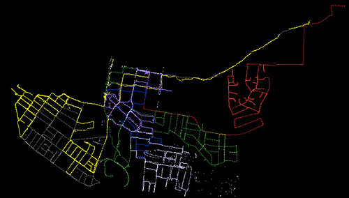
Check out Tim Waters (chippy) animations of GPS traces during the recent Leeds mapping party:
SitesCollide podcast
Here is a podcast with Raphael about OSM.
Victoria, BC. Mapping Party Day One
By the end of the first day of mapping in Victoria, Canada, we’ve covered a fair swath of the city:
There’s more to come tomorrow, and Monday, so come along and join in the mapping fun.
Mapping Parties, Demos Talks – Its all happening in Victoria, Canada
by Nick Black
OpenStreetMap is coming to Victoria, Canada. There’s going to be a load of OSM related activities in the city that boasts Canada’s mildest winter temperatures.
| OpenStreetMap Mapping Party | Sat 22nd – Mon 24th September |
| OSM mapping around the conference area | Monday 24th September |
| OSM talk at FOSS4G | Tuesday 25th September |
| OSM demo session | Wednesday 26th September |
| Post FOSS4G Code Sprint | Friday 28th September |
So if you are in the area, come along and join in the mapping fun. The usual stuff applies – its open to anyone, we have GPS units, its fun, sign up here
Leeds Mapping Party this weekend
Come to sunny Leeds this weekend for a awsome mapping adventure, where we try to map all of Leeds. Then go for beer and curry.
Also coming up are parties in Victoria, Canada, East Hampshire, Västerås, Sweden and Sheffield!
ITO! animation
OpenAerialMap – Community contributed aerial imagery
By Nick Black
The recently back-from-the-brink-of-death Slashgeo, links this morning to an interesting open geodata initiative – OpenAerialMap. As the name suggests, OpenAerialMap is an attempt to aggregate as much free aerial imagery as possible. This makes a lot of sense. In the same way that I can go out with a GPS and map my street, I can fly my UAV over my street and gather imagery, safe in the knowledge that my neighbour a few streets away is doing the same thing. We join it all up and get a free image map of the world.
A technical problem to solve will be to rectify images to make them usable with other mapping/GI systems. This requires the use of ground control points, either gathered from existing maps or imagery (as seen in the MetaCarta rectifier) or based on GPS positions. Right now, OpenAerialMap have opted for a one at a time approach – with users uploading an image and manually rectifying it – presumably against public domain, or maybe even OpenStreetMap maps. None of this is actually up and running yet – the project is still in the planning stage.
The licensing of the project is unclear – there’s a lot of talk about freedom and open source, but nothing concrete about what the license actually is. Aa OAM haven’t started accepting uploads yet, there’s still time to choose a license that will maximise the usefulness of the tool they are creating.
As you would expect, OpenAerialMap talk a lot about community on their wiki. Unfortunately, as of this morning editing the wiki has been frozen temporarily until we clearly define appropriate use. So in the mean time, you can subscribe to the mailing list to find out more.
JOSM goes multi data layer
The latest JOSM now supports multiple data layers again. This was requested since about the day after I removed the feature over a year ago ;-).
As another big data source hits the main database (AND’s netherland-parts-of-china-and-india map) the feature got more urgent. I think it is especally cool for people who want to compare two unrelated datasets ;-).
Every file open and every download opens the data into a new, seperate layer now. You can merge these layers using the merge button in the layer dialog. By selecting an layer in the layer dialog, you can switch the current editing dataset as needed.
Now for the bad news:
As the feature is a ground shaking one for the whole JOSM data holding structure, I expect many new bugs introduced :-(. If you run into problems that block you from mapping, please revert to the latest release from last week.
For Plugin writers:
Plugins, that used Main.ds could be affected as well. Main.ds now holds the dataset of the current editing layer rather than all the data together. If you are a plugin writer and your plugin is broken and you cannot fix it to work with josm-latest *and* the josm-1.5 release, please link a version which is working with the latest release at http://josm.openstreetmap.de/wiki/Plugins/LatestRelease.
New Release: JOSM 1.5 “Hits The Road”
Hi,
after almost 9 months of more or less JOSM-coding, I finally announce a new JOSM release. In shortage of a better name and in spirit of the good old Sam & Max adventure game (which I finished yesterday.. Hurray!), I hereby call this release: “Hit The Road”. 😀
Before I get to the new features, I want to Frederick Ramm, Christof Dallermassl, Francisco R. Santos, Bruce Cowan, Thomas Walraet, Martijn van Oosterhout and all the other guys I forgot who send in patches, bug reports and ideas and who wrote plugins for the community. 🙂
Ok, now to the facts:
download: http://josm.openstreetmap.de/download/josm.jar
mirrors: http://wiki.openstreetmap.org/index.php/JOSM#Requirements.2C_download_.26_installation
online-help: F1 (or http://josm.openstreetmap.de/wiki/Help)
bugs: http://josm.openstreetmap.de/newticket
Some new features since the last release
- 0.4 complaint. I bet you already noticed that in the latest beta 😉
- Tons of new modes and tools as split / combine ways, reorder nodes in
a line, reorder segments in a way, (un)select all… - Better support for plugins. There are over a dozen plugins
already available. A basic plugin downloader has been integrated into
JOSM to ease the plugin installation process. See
http://josm.openstreetmap.de/wiki/Plugins for more - The MarkerLayer displaying annotations from gpx tracks.
- More visualization options, e.g. drawing the segment ordering number
or drawing boundary rectangles of all downloaded areas. - HCI improvements as one-time warnings, customization support for the
toolbar on top (including annotation presets), detach the dialogs
on the right, welcome screen, cuter images… - And of course: fixed tons of bugs.
I hope you enjoy the new release and good mapping.
Ciao, Imi.