The Dutch OpenStreetMap community has opened up a weblog on OSM in the Netherlands. Check out http://www.openstreetmap.nl (in Dutch).
PlanningAlerts.com
Want to know if there’s a proposed phone mast or new house to be built near you? Check out the awsome PlanningAlerts.com, a simple way to keep track of these things.
To make this magic work, they need tedious bits of software which scrape data off of council websites and put it in a usable form. I wrote two last night… have some spare time? Hack your own together!
OSMonth: Day 19
Bit of a gap since day 18 I know, but work and organising openstreetmap stuff got in the way of working on openstreetmap. So, today lets try to get some rails done in the calm between bugfixes;
- Moved the planet generation back to 1am rather than 4am which was for db problems last night
- uploading new planet in to the (mapnik) tile server. For some reason it’s not putting rendered tiles in the db since the engine change from myisam ti innodb, investigating. Hrm the filesystem has millions of directories for the temporary files… deleting…. new planet now imported… tiles seem to be rendering but there’s a backlog.
- Fixed the mime type bug on planet.openstreetmap.org, now figuring out why I can’t log in to trac. Ok fixed the login bug. closed bug 383 (mime type)
- getting stevecam back up, waiting for tile server to load up new planet. Quick recompile, stevecam back up!
- So it turns out the tile weirdness is because people have been trying to spider all the tiles. But, since many tiles don’t exist they get entered in the dirty queue to render.. which just expands… and expands. I’ve blocked the ips responsible and am now implementing a limit. 🙁
- lunch
- Limit implemented. It’s now 2,500 tiles / day / ip. Also, tiles which havn’t been viewed in more than a month (28 days) are deleted every day. See stuff over here for implementation. Cool all seems to be working.
- deployed new openlayers, closes #310
- replying to a ton of mail, organising various conferences and stuff I’m speaking at for OSM…. Added to wiki events page
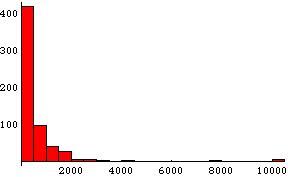
- Some final food for thought. Here’s a histogram with number of ip addresses on the y axis, number of tiles downloaded for the past 5 or 10 hours. As you can see the vast majority of people download under 2,000 tiles. But we get the odd person grabbing 10,000 or so. What should the limit be?
The Pragmatic Mapper (part deaux)
My pragmatic mapper post brought some interesting responses so I thought I’d outline it a bit more.
First, the title is a riff on The Pragmatic Programmer
It’s also an explicit riff on Linus Torvalds explicit pragmatism and differences of opinion with the more political FSF. The FSF is freedom for freedoms sake, Linus is freedom because it’s just better. I like the latter.
On the points of does the OS matter, generally, for some value of matter. Of course they do. They’re much like Microsoft. They’re a monopoly, they have lots of money and giggly lawyers and everyone hates them. They also have maps of the whole country. But do they matter to me, personally, or many OSMers? No. The political side and bringing down The Man doesn’t really motivate me. We make OSM because it’s better and cooler.
I do find it interesting that the responders think that a national mapping monopoly is somehow a good thing. I fail to see how this is different from a national monopoly on tea bags or cars. It seems that the argument is that the OS is relevant because it has lots of data and we could use this (pulls rabbit out of hat) in a flood emergency. Bit of a poor use of a lot of money just for that. Anyway, to respond to points in turn;
…I want someone to organise data cross the entire country. I want to operate a business dependent upon that consistency.
Thats fine, but you don’t need a NMA to do that. You could have regional agencies with individual contracts where an overseer body puts it together. You could, god forbid, use OSM when we’re there. On an economic note, even if you want all that, and you want an NMA that’s fine, just please don’t force me and the 65 million other citizens to pay for it as we might not want it.
…I want to know that environmental policies in the north and south are based on similar data, its analysis and methodology and applied fairly.
Cool, but still don’t need an NMA for it. We have policies in the north and south are based on similar data, its analysis and methodology and applied fairly in schools, hospitals, roads, universities, water, gas, electricity…. most of these just need an overseer not an NMA.
…In the case of an emergency, I want to know someone can put together a river network and all its tributaries and work on solving a hydrological problem effectively, if there is a need.
Still don’t need an NMA for that. Being a bit hardcore, the emotive issues of ‘think of the children!’ or ‘what if we get flooded’… well the insurance market is very clear about that. Don’t live in a flood plain. If you want amazing disaster recovery maps of your area, then pay for it but please don’t force us all to. We might want to, of course, just don’t force us. And Katrina is not a good example, the federal government distorts the market by forcing flood insurance through FEMA. It’s the same argument as keeping rural post offices. If people in the countryside want them, then pay for them. There’s no god-given right to maps and post offices.
…I want someone to survey and record the entire country in case I want to visit other parts, know what is there and understand where I can go.
What do you do when you go to the united states then? The country isn’t falling apart because they have different mapping providers in different parts of the country. I can find my way around Orlando and San Francisco just fine, despite them being thousands of miles apart and one with a map from Hertz and the other from the county sheriff.
…I want an agency who supports governmental operations in a neutral manner with spatial information.
So do I. It need not be a country-wide monopoly. And the OS are far from neutral. By definition they stifle competition and progress, without even waving around OFT reports.
…I want someone responsible for ensuring the education system produces infrastruture and knowledge to people so the geography of the land is know, recorded and stimulated.
University Geography departments would not be impotent without the OS. 11 year olds can still learn about geography without a free map.
I wonder if Openstreetmap honestly feel that they are ready to provide disaster response mapping, or have the resources in place to ensure that their coverage of the entire country is current to within one year or less.
Not yet, but we or someone like us will. And anyway, you don’t need an NMA for disaster response mapping.
It’s perfectly fair for OpenGeoData to think that Openstreetmap suits his mapping needs, but to call it superior, and to say that the Ordnance Survey is irrelevant is a little short-sighted.
Navteq are letting you submit errors and so are teleatlas with map insight. Our way of making maps is most definitely superior and it’s the future.
If you can, listen to this podcast which excellently summarises The Wealth of Networks
To come back to the original post for a second, really the pragmatic point was to say should we spend our time campaigning against the OS, or just building our own systems and maps? Campaigning for open data from the OS, or change to government policy is just sticky tar. Would we have got anywhere in the past two and a half years by just campaigning? It’s very doubtful. We’d have publicity no doubt and a few more high-placed friends and enemies… but this way we have that and a mapping system, and a community of 5,700 people, and maps of Baghdad, and vast sections of the UK mapped.
I have some idea of what I’m talking about here, as I’ve been involved to varying degree with fipr, no2id and stuff.
But one thing I think would be cool to do is make a map of map charges. The idea is that the OS basically don’t respond to awkward questions through the Freedom of Information Act as they’re commercially sensitive… but if we all write to our councils and ask them then they have to give us at least some idea. My council just sent me a letter with the new council tax bill breaking it down by police, schools and so on.. but not maps. So, we can figure out who’s paying the OS too much or little. It’ll be interesting. What you need to do is find your council website and information freedom officer and write them a letter asking for this stuff. There’s a wiki page with a sample letter to help you get started.
As far as I know this data doesn’t exist anywhere.
Another Week on the OSM Mailing lists…
Happy first birthday to Osmarender. As Blackadder/Andy Robinson pointed out this week Osmarender is now a year old. Before Osmarender there was nothing that generated maps from OSM data, and right from the start it performed well. Over the year Osmarender has added support for layers, areas, symbols and bridge/tunnels to give the Osmarender we have now. Compare the two maps below of Weybridge from the first to the latest incarnation of Osmarender. Also, Osmarender is the rendering engine in the times@home project which turns round updates to the map very quickly. It will be interesting to see what the next year will bring. Great inspiration Etienne & great work to all the collaborators ….

Mapping and rendering tunnels came to the fore this week with Steve Chiltern starting a discussion around just how do you really map out a tunnel (the astute of you will realise that GPS coverage is not the best in a tunnel). Various solutions were proposed with video-based surveying & inertialmeasurement units sounding promising. Not sure about the wire-guided missile idea though! Mind you, with a tunnel engineer amongst the OSMers some progress should be made. The issues of layering and tunnels was also covered here.
The question of how to get tiles updated on the map seems to come up again and again. Well, for the Osmarender view go to http://www.informationfreeway.org/ zoom in to level 12 on the area you want, and click ‘request update’. There’s talk of getting this implemented as part of the slippy map too. On the dev list there is discussion of a JOSM patch to allow the same kind of thing.
A great discussion kicked off by Andy Allen on tagging MBR trails (Ed: he really meant MTB trials). Should they be covered by a route tag? Should they be given grades? Should there be an ascii-art description of the route surface ( nnn=cobbles, __~~~___=flooding etc.). Looks like there will be crossover from the MTB community to get some mapping done. Great!
SteveC’s thread on Finding new stuff while mapping points to the joy of getting out on the road. Being ‘forced’ to go down every lane/track/path brings out lots of things you’d probably never noticed about your local area. So what are you waiting for? Get out there & see your place in a a whole new light!
This gets my thread-of-the-week award: The set of problems thrown up by the question of maximum segment length by Scott Walde. It started off by problems with things not rendering properly and segments being missed because the start/end of the segment was out of the area being rendered (though it did cross the area). Adding a point in the area ‘fixed’ this. Being a global discussion it brought up a whole range of issues on road networks – a 50K straight road is not uncommon in some places, as are grids of roads running north/south & east/west. And what happens with different projections – well worth a look. So how long is the longest stretch of straight road in the world?
There were a few things of general note on the dev list this week. Thomas Lunde brought up the US TIGER import problem. TIGER is a database of all the streets in the USA. Lets say that again: TIGER is a database of ALL the streets in the USA. And there are no copyright restrictions on using the data. Handy eh? There was an import of the data running for quite a while, but it had to be purged because of data cleanness problems. A new version of the TIGER data has come out (as of the 6th March) and there is discussion of re-running the import, and how best to do this given the existing mapping that has happened in the USA. Separately on dev Andreas Voltz asked about Writing an OSM map application and received a bunch of useful information about OSM data & appropriate databases.
The number of mapping parties is growing like topsy. Last year there were seven. There are three this March, and ten so far either happened or planned this year to June. These parties have given step changes in the mapping around Manchester, Bath, Reading, Brighton, The New Forest, VÄsterÃ¥s, Rutland, Munich, Val Thorens, London, Toronto, Bristol, South London, Amsterdam (last weekend), and planned for Sheffield, Karlshrue, Madrid, Southampton and North Wales. This doesn’t include the recent funding where 12,000 euros have been earmarked to subsidise another ten mapping parties in the Netherlands this year. Way to go!
Don’t forget: If you want to submit something to OSM’s State Of The Map Conference, you had better get your skates on. The closing date for submissions is the 30th of March.
Legal-talk has been strangely quiet this week…..
by Barry Crabtree.
State of the Map 2007 – Conference Update
Preparations for the State of the Map 2007 is in full swing. Head over to StateoftheMap.org for the latest news, including a preview of some of the talks and workshops planned for Manchester in July.
To be kept up to date with the latest announcements, you can subscribe to the State of the Map feed, or email registration@stateofthemap.org to be added to the mailing list.
The Pragmatic Mapper
A great interview with Linus (that guy who started linux) where he says:
Me, I just don’t care about proprietary software. It’s not “evil” or “immoral,” it just doesn’t matter. I think that Open Source can do better, and I’m willing to put my money where my mouth is by working on Open Source, but it’s not a crusade — it’s just a superior way of working together and generating code.
Lets rephrase that in the mapping context:
Me, I just don’t care about the Ordnance Survey. It’s not “evil” or “immoral,” it just doesn’t matter. I think that Open Maps can do better, and I’m willing to put my money where my mouth is by working on Open Maps, but it’s not a crusade — it’s just a superior way of working together and generating maps.
OpenStreetMap subsidised in the Netherlands
The Dutch branch of OpenStreetMap received a grant of 12.000 euro! The goal is to organise ten mapping parties in the coming nine months. Focus will be on mapping Amsterdam, Rotterdam and the Hague and – most importantly – to get the community jump started in the Netherlands.
Last week was the first try-out party. With a group of 10 people we started with the centre of Amsterdam. Check out the results:
 !
!
Cadcorp do it again
Very soon you’ll be able to get a plugin from here to download tiles within SIS!

Law in Action programme and debate
Tomorrow at 4pm there is a programme on Law in Action on Radio 4 in which they examine crown copyright, openstreetmap and the OS. You can listen online.
Then on Thursday there is a debate with Andrew Gowers at the Francis Bancroft Lecture Theatre, Mile End Campus, Queen May, University of London at 5pm. You need to RSVP to this address to get in.