The default OpenStreetMap.org “standard” map was switched across to a new rendering server setup over the last weekend.
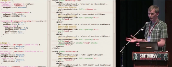
In addition to new hardware, the rendering server also uses the new “openstreetmap-carto” stylesheet. This is a complete re-write of the old XML stylesheet to use CartoCSS, making it easier for our cartographers to work with. The style is designed to look as similar as possible to the old XML stylesheet.
Andy Allan presented a great talk at State of the Map US conference describing the reasons for re-writing the stylesheet: Putting the Carto into OpenStreetMap Cartography
Andy will present a follow-up at State of the Map next month.
The “openstreetmap-carto” stylesheet is maintained on github
“openstreetmap-carto” is a good base for creating custom styles, and should be much easier to work with. If you want to help improve the style, or add new features, please fork it and contribute pull requests!
Please support OSM’s server hardware fundraising drive