Community and communication are key to the success of OpenStreetMap project, yet discussions about individual edits have always been clumsy and awkward. In this post, I’ll describe Changeset Discussions, a new feature of the OSM website which allows people to have public discussions around changesets.
Before Changeset Discussions
Before the introduction of Changeset Discussions, the only way to communicate about a changeset was either to use an out-of-band communication medium, such as mailing lists or forums, or to communicate directly with the author of the changeset by OSM message. Both of these methods are clumsy.
The result is that it was often difficult to discuss changesets. New users rarely received any positive feedback or helpful instructions, and controversial edits were often handed off to the DWG instead of being able to have an public discussion about them.
Introducing Changeset Discussions
Changeset Discussions address this problem by letting users have a discussion about a changeset directly on osm associated with that changeset. This discussion is public, which allows for contributor collaboration.
This feature works similarly to the comments placed on an OSM Note, where users may discuss a note publicly, for example to ask for more information from the note submitter.
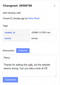
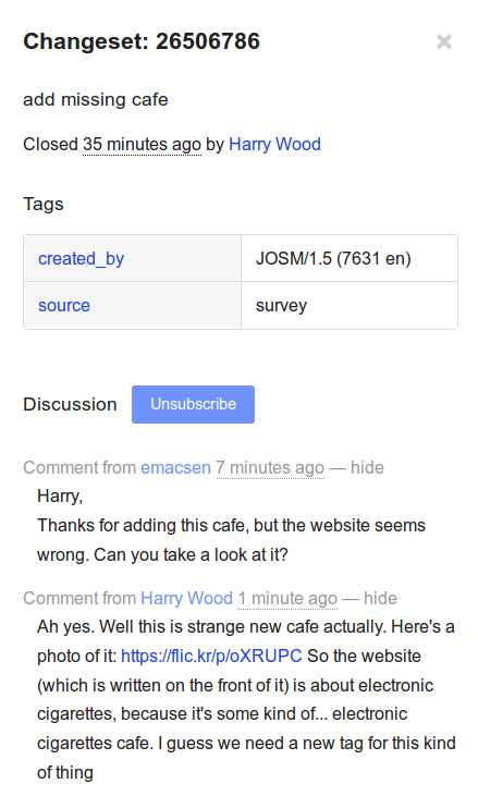
Leaving a Comment on a Changetset
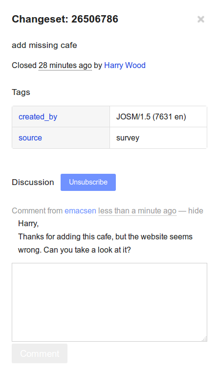
Changeset discussions now part of the OSM website. To use them, on the changeset page, on the left hand side, you can enter a comment:
Then click submit, and the comment appears:

Once Harry replies, as he’s done here:
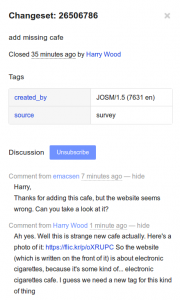
…I receive an email notification.
Subscribing/Unsubscribing from a discussion
Once you have made a comment to a changeset, you will receive notifcations about new comments placed on the changeset, keeping you in the loop and part of the discussion. You may also choose to watch a changeset discussion without participating in it, by using the
Subscribe button.
If you don’t want to continue to watch the changeset, just press the Unsubscribe and you will no longer receive alerts of new comments.
Use Cases for Changeset Discussions
It’s been pointed out before that OSM has a problem in communicating with our new users. Changeset discussions can be a perfect place to congratulate on their first edit.It can also be an opportunity to help new users by giving them specific feedback where they might not have been as strong, giving them specific feedback on tagging, for example.
- Leaving Positive Feedback
As a community, we don’t reciveve much positive feedback on our edits. With changeset discussions, you can leave a positive comment on a changeset expressing your thanks.
- Asking Questions About Controversial Edits
If you have a question about an edit, such as why a name was changed, or a road was reclassified, you might want to ask the user why they made the change. Putting that question directly on the changeset gives the original author to receive feeback from you, but to respond to that feedback in a public forum. This should result in more open, public discussions and hopefully fewer conflicts.
There’s an API
Changeset Discussions also have an API component, which will be documented on the wiki, which will allow this feature to be integrated into OSM editing software directly, further connecting the editing process with the communication/community process.
Special Thanks
Changeset Discussions came into OSM by way of Google Summer of Code, specifically by our student Lukasz Gurdek, who I had the pleasure of mentoring. His work was of absolutely Grade A calibre and it was a pleasure working with him.
Also, a huge debt of gratitude to Tom Hughes, who worked with myself and Luksaz to get this code merged into the OSM.org codebase. Without his hard work, this feature branch might have never made it into the website.
And of course I want to thank Google for their Google Summer of Code project, which made this possible
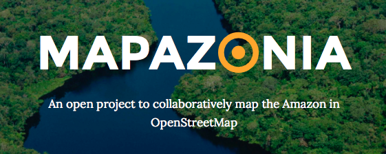 The Amazon rainforest includes territory belonging to nine different nations and there are a lot of environmental institutions and governments that need better geospatial data to do their work in that region. Furthermore it’s always good to have quality data in case of a natural disaster or other humanitarian issues. In Brazil there aren’t many editors in this northern region, so there are a lot of towns without any data and some roads to trace.


