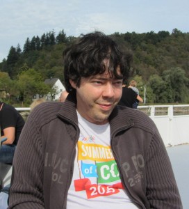
New foundation board member Peter Barth
One month has passed since the elections, so I decided to write down a little blog post about my impressions as a new board member. Even though I had listened into a board meeting and participated in an OSMF working group before, there were still many things to learn and new tools and processes to get acquainted with. This post is not super specific, but I still hope this will be an interesting read for others who are curious how the OpenStreetMap Foundation board works.
The infrastructure
Once the election results came in, everything happened quite quickly and we got a bunch of new accounts for various services. As you might remember, the election results were final on December 12, 2015 around 19:00 (CET). Less than 6 hours later, I was added to the internal board mailing list (the board@ address). Well, perhaps I was added earlier, but at 00:27 my first board mail arrived. This list is the main communication channel for the board and almost anything is discussed there. The address can be used by anyone, by the way, so if you have any matter to discuss you’re free to write to this address to reach the whole board – though reading is limited to the board directors. Just to give you an impression about the traffic, I got 266 mails until today on that list. Only 25 hours after my election I also got a personal @osmfoundation.org mail address which should be used whenever I want to speak as an official board member. Mails sent to these addresses are handled and, depending on the configuration, archived by Google.
The same day, we got accounts for the public OSM Foundation wiki and for the private wiki of the board. The latter is to be used for internal stuff, e.g. it now contains a primer page with all the stuff new members need to know. I haven’t changed much myself yet, but I read a lot and even though the wiki is not that large (about 30 pages), there is much information to process.
In addition the above, there’s a service called Loomio, which is used for deciding on board resolutions outside of meetings, so called circular resolutions. That seemed kind of superfluous to me, but it appears to have been introduced some time ago to make it easier to manage resolutions as there was a lack of clarity about status and conclusion and as resolutions via emails had a low number of participants. (When the first circular resolution of this term passed, Paul almost incredulously noted that this was the first time he ever saw all board members vote.). Anyway, the tool itself is neatly organized, easy to use and you can choose to receive email notifications when something happens within our group.
The board does not have a ticketing system, by the way, but has great human tracker: Paul. He collects items from the mailing lists and amazingly manages all that so nothing gets lost. Other than that, everyone has their own list of open items. Not everyone was happy with this, however, so we discussed whether to try something different this term. That’s why there will be a trial period where we use the issue tracker of GitHub to keep track of open tasks, assign tasks and so on. We’ll see how that turns out.
There are some other tools in use, too, but there were no special actions needed to set them up. For example, we use Doodle to agree on a date and we use Mumble for our meetings. We have an IRC channel to talk to each other, though seeing how not everyone is used to irc, it gets used to chat rather than discuss. And finally there is CiviCRM for the members’ database, accessible via a WordPress plugin. But it took me a while to get access to that one, as I did miss the invitation mail.
Legal obligations
As the secretary needs to submit an “Appointment of a director” form to the Companies House, I had to give some personal details to Paul, including my date of birth and my private address. It’s the directors’ duty to submit this information, as the details about the directors on the board have to be made public, according to British law.
I’m also working on getting access to our bank account as I was selected as a backup for our treasurer. After trying to get hold of someone explaining me how to do that and struggling to understand the London dialect of a nice lady from customer support at Barclays, I was glad that Frederik was able to help me. Eventually, I had to get an certified copy of my ID, fill out a bunch of forms and be very cautious to put my signature within given bounds to not invalidate these forms. And now I’m waiting to see what happens. If I’m unlucky, I’m going to have to travel to Frankfurt to appear in person at Barclays.
Getting started
So with all the preparations out of the way, what has the board worked on since the elections?
During the last few weeks, we processed a few tasks related to our working groups, such as budget requests. Unfortunately, there were also legal disputes affecting the DWG that the board had to deal with. We used the opportunity to talk at length about our interactions with working groups in general, and how to support their work without interfering with it. Naturally, there were different ideas and interesting discussions, and I expect that there will be small but exciting changes to come. As much of the actual work is done by the working groups, they form an integral part of the OSMF and OSM in general. Other than that, we also dealt with some inquiries by different NGOs, and of course there were mails from newbies like me, asking silly questions.
Whenever there are topics that need to be decided on, we use votes to form a consensus. Either at one of our Mumble meetings which take place one a month, or via Loomio as a circular resolution if the topic can’t wait or is considered simple enough to not warrant any discussion at a meeting. For something to get passed a simple majority is enough, and notably there’s no quorum to be reached. In theory, it would be possible to decide on something with only one vote in favor. (No, that hasn’t happened yet.)
Conclusion
Now that I’m getting more familiar with the way things work, I’m eager to work on the challenges I outlined in my agenda, and I’m sure my colleagues are, too. As always, the board is happy about any input or contribution on osmf-talk@, by direct mail or to the OSMF in general. Even if a matter is already discussed on the board, it feels good and necessary if the members discuss topics, suggest things and demand answers, too. So please continue contributing to osmf-talk@ to make it a livelier place.
And last but not least I hope that this post has been an interesting read that can help others who consider running for the board, contributing to one of the great working groups out there, or simply joining the OSMF as a member.
Peter Barth


 It’s soon time for members of the OpenStreetMap Foundation to elect new leadership to the OSMF board. The foundation board is made up of seven people, of whom three will be remaining for an extended term, while four seats are up for election.

