OSM the default map in Haiti

Check this out:

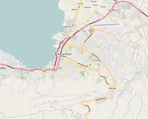
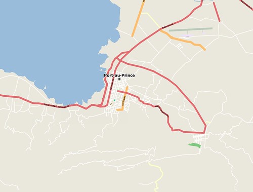
[..] I am currently in Port Au Prince with the Fairfax County Urban Search & Rescue Team (USA-1) out of Fairfax, VA, USA. I wish there was a way that I can express to you properly how important your OSM files were to us. Most of our team members own their own Garmin Rino and 60CSx units on top of the units we already have in the cache. Having these detailed maps on our GPS units is a big deal. Shortly after discovering your work I quickly spread the word and transferred the street level maps onto as many Garmin units as we could before sending the American rescue teams on the streets. The team members are thrilled to have this resource you have created. I wish you could see their faces ‘light up’ when I take their GPS unit and tell them that I’m going to give them street level detail maps. They have been working VERY hard and anything that can help them in every aspect of their mission here is greatly appreciated. I am spreading the word about this work to all rescue and humanitarian teams on the ground here in Haiti. Please be assured that we are using your data – I just wish we knew about this earlier. THANK YOU!

Check out the wiki for more.

Fixing Megabridges in TIGER

For some reason … for whatever reason … the TIGER data has some entire ways marked as being bridges.  When examined, only a small portion of them is a bridge. I’ve been fixing them as I happen to notice them, but today I felt like seeking them out. I thought about writing a fancy program to parse the New York State section (as found on <a href=”http://downloads.cloudmade.com”>Cloudmade downloads</a>) to look for bridges.

I was reminded, instead, that the XAPI can do its own cut of OSM data. It’s fairly straightforward to do. The full XAPI documentation is in the wiki. All I did was fire up JOSM, and make a few bounding boxes around New York State. I did three: one for the southern tier, one for the adirondacks, and one for the NYC metro area. The first one’s URL looks like this: http://www.informationfreeway.org/api/0.6/map/way[bridge=yes][bbox=-79.6289,41.9677,-73.3667,43.3731]
I fetched it with wget -O southern.osm ‘URL’.  It’s only five megabytes and loads into JOSM easily.

Once loaded into JOSM, you can see the very long bridges. They stick out like a sore thumb. I pick one, zoom in to fill the screen with it. I have the Terraserver Ortho WMS layer turned on, so I can see where the bridge really should be. Two selects of nodes, split the way, and delete the bridge=yes tag. I’ll have New York State fixed up in about an hour’s worth of editing (not counting the time to write this blog entry).

Haiti OpenStreetMap Response

The have been at least 400 OpenStreetMap editing sessions in Haiti since the quake hit. Mostly tracing Yahoo imagery, and gleaning information from old CIA maps. We also just received permission to use GeoEye imagery acquired post-event … that will allow us to tag collapsed buildings. Many relief groups are deploying now, many checking in with the CrisisMappers list (the main locus of the wider humanitarian tech community), and they are making inquiries into OSM data and requests for particular features. Dozens of mappers and developers are lending a hand, coordinating on the OSM Haiti WikiProject and IRC and the OSM talk list … standing up services, including 5 minute extracts in Shapefile and Garmin formats, and maps with hill-shading. Just the start to relief and reconstruction effort we hope to contribute to.

Two images to show how we’ve progressed … the first OSM Port au Prince just now, the second OSM before the earthquake.

haiti.osm.20090114180900

haiti.osm.pre-event

I’ll be on twitter with updates … though I’m due to fly tonight to Ireland.

OSM article in today’s infoworld

Nice article here:

A volunteer-led project to create an open-source map of the entire earth, calledOpenStreetMap, has amassed over 200,000 contributors since its inception, the founder announced in a blog entry.

The project has attracted over 100,000 users since last March alone, noted founder Steve Coast. He predicts that, given this rate of growth, the contributor base will reach a million by this August.

Maposmatic updated

Maposmatic – the site which lets you make OSM maps with grids and indexes – has been updated with a bunch of new features:

* Support for the whole world. Any location in the world can now be
rendered on maposmatic.org.

* OpenStreetMap database updated daily. Until now, the database had
never been updated since the service was started in September
2009. Now, the geographic database used to render the maps is
updated daily, providing maps with the latest contributions to
OpenStreetMap. Each map contains the date at which it was
generated.

* Better city search engine. Thanks to Nominatim, we now provide a
search engine that allows to find cities in a much more usable way:
cities with the same name can be distinguished and the search works
even when the city name is not completely correct.

* Support for other languages. A few parts of the map rendering
process is language-dependent and we now have the infrastructure to
use language-dependent code. For the moment, we support English,
French and Italian, but we are waiting for your contributions to
support other languages. The website has also been translated to
German and Italian.

* Amenities in the index. In addition to the streets, we have added
important amenities to the index: schools, town hall, post offices,
places of worship, etc.

Meteor Mapping

800px-Meteor_Crater_-_Arizona

Metero Crater is the well-named meteor crater in Arizona created by a “nickel-iron meteorite about 50 meters (54 yards) across, which impacted the plain at a speed of several kilometers per second. The speed of the impact has been a subject of some debate. Modelling initially suggested that the meteorite struck at a speed of up to 20 kilometers per second (45,000 mph), but more recent research suggests the impact was substantially slower, at 12.8 kilometers per second (28,600 mph). It is believed that about half of the impactor’s 300,000 tonnes (330,000 short tons) bulk was vaporized during its descent, before it hit the ground.[7]”

I drove the 3 hours there, then 3 hours back to visit it from Phoenix, Arizona yesterday and took some pics:

And of course I mapped it. There are a bunch of footpaths, a subway fast food restaurant, lookout points and so on. Of course someone had already mapped the crater rim and the car park. Check out the map here.

License Working Group podcast

As many of you will have seen the OSM project is in the midst of shifting license due to problems with Creative Commons applicability to data. You can read why here, here and here. There has been a lot of discussion on the mailing lists about this and with any license debate in an open project a lot of FUD. Today Matt Amos and Mike Collinson, members of the LWG together with Peter Batty, Richard Fairhurst and myself produced a podcast which covers many of the issues. To discuss more please feel free to comment on this post or join the legal mailing list where this has been discussed approximately 9 billion times over the last 2 years.