Bravo, OSM Haiti editors. You saved lives.

From Where 2.0, Jeffrey Johnson (Open Solutions Group), John Crowley
(STAR-TIDES) and Schuyler Erle (SimpleGeo), “Haiti: CrisisMapping the
Earthquake”

[blip.tv http://blip.tv/play/AYHS2l4C]

At the end, hundreds of OSM editors get a round of applause for
contributing to editing Haiti. And saving lives.

SotM and FOSS4G combo tickets!!

This year two major Geo conferences (SotM and FOSS4G) will be held in Spain. State of the Map in Girona and FOSS4G in nearby Barcelona.
Given that the two conferences are held in close proximity, both organizing teams are of the opinion that people attending both should have a perk!
Therefore, we are proud to announce a discount to people who sign up for both events!

Logo_foss4gsotm

Forget about complicated options for different combos. This mix ticket discount will allow people attending one conference to enjoy a discount on the other. To put it in another way: if you register for the FOSS4G, you get a discount for SotM10. If you are hesitant to go to the FOSS4G but have already registered for SotM10, you’ll have the early bird price no matter how late you sign up.

Already signed up for FOSS4G? No worries. Those who have already registered for the FOSS4G, will be sent an e-mail detailing how to apply for a SotM ticket with 10% discount.

To get the best deal, register with FOSS4G first; while their early bird is still available. You’ll then get a discount-voucher with which you can get 10% discount on SotM tickets.

If you’re into geo, Spain is definitely the place to be this year!

Map Kibera project featured on Flickr Blog

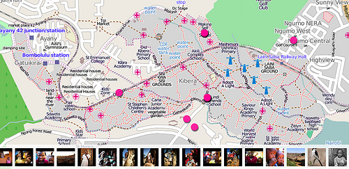
Media_httpfarm5static_zxhfg

The Map Kibera project (http://www.mapkibera.org/) is putting Kibera
on the map.

Kibera in Nairobi, Kenya, widely known as Africa’s largest slum, remains a blank spot on the map. Without basic knowledge of the geography and resources of Kibera it is impossible to have an informed discussion on how to improve the lives of residents.

Flickr is able to use the map created by Map Kibera and OpenStreetMap
(http://openstreetmap.org) for placing Flickr geotagged photos.
(http://www.flickr.com/map?&fLat=-1.3126&fLon=36.7937&zl=1)

See the Flickr Blog entry here
(http://blog.flickr.net/en/2010/03/31/map-kibera-project-on-flickr/)
and keep up with the Map Kibera (http://www.mapkibera.org/blog/) and
right here on OpenGeoData.