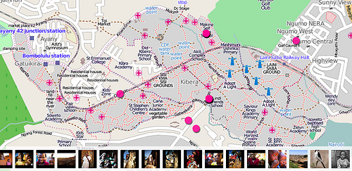
The Map Kibera project (http://www.mapkibera.org/) is putting Kibera
on the map.
Kibera in Nairobi, Kenya, widely known as Africa’s largest slum, remains a blank spot on the map. Without basic knowledge of the geography and resources of Kibera it is impossible to have an informed discussion on how to improve the lives of residents.
Flickr is able to use the map created by Map Kibera and OpenStreetMap
(http://openstreetmap.org) for placing Flickr geotagged photos.
(http://www.flickr.com/map?&fLat=-1.3126&fLon=36.7937&zl=1)
See the Flickr Blog entry here
(http://blog.flickr.net/en/2010/03/31/map-kibera-project-on-flickr/)
and keep up with the Map Kibera (http://www.mapkibera.org/blog/) and
right here on OpenGeoData.