After careful consideration, effective immediately Mikel Maron, Andy Robinson and Mike Collinson have access to the moderation system across the main OSM mailing lists. They will use their best judgment according to the moderation guidelines and they enjoy the full support of the OSMF Board.
Project of the Week: Tennis
http://www.flickr.com/photos/79071998@N00/297686409/
The project of the week is a fun way to get out and map something that
you might not map otherwise. This week we’ll map tennis courts before
we run home to watch the matches at Wimbledon.
First job: Make sure all your local tennis courts are on the map!
This is your Project of the Week. Make suggestions. Inspire other
mappers. What is it about contributing to OpenStreetMap that
interests you? Postboxes? Bowling alleys? Share your OpenStreetMap
interests by suggesting a Project of the Week or Project of the Month.
Tennis ball photo by catbaggan is
licensed CC-By-NC-ND
Q3 2011 Service reductions
Some secondary OpenStreetMap services will be unavailable during the
following dates, due to power maintenance work at our server hosting:
– 2nd and 3rd July 2011. (Saturday & Sunday)
– 30th and 31st July 2011. (Saturday & Sunday)
– 3rd and 4th September 2011. (Saturday & Sunday)
– and 1 weekday (to be confirmed) during August 2011.
On each of these weekends, the servers will be shut down at 7:30 UTC,
and will be started again after works are completed, which will be
Sunday 16:30 UTC at the latest, but may be earlier. We do not yet have
a precise date for the August maintenance.
The following services will be unavailable during these periods:
* XAPI / jXAPI
* dev.openstreetmap.org server (errol)
* rendering of new map tiles
* osmfoundation.org and stateofthemap.org web sites
As a temporary replacement for XAPI/jXAPI, consider using third-party
services such as that provided by MapQuest:
http://developer.mapquest.com/web/products/open/xapi
Additional information will be posted to the following page:
http://wiki.openstreetmap.org/wiki/Power_Maintenance_Q3_2011
The following services are *not* affected:
* www.openstreetmap.org web site
* API and Editing
* planet.openstreetmap.org and diffs.
* tile serving for existing tiles (details below)
* Wiki
* Nominatim (search)
* mailing lists
* subversion and git (source code repositories)
* trac (bug-tracker)
* donate.openstreetmap.org
Maps will still be viewable on the openstreetmap.org homepage and on
other people’s websites. We’ll be serving tiles from a back-up tile
server. However rendering engines will be deactivated, meaning that
new rendering of map updates will not take place during the
maintenance period, some requests for tiles will fail where no cached
copy is available, and tile response times may be slower than normal.
Q3 2011 Service reductions

Photo by strollers on Flicker, CC-By-SA
Some secondary OpenStreetMap services will be unavailable during the following dates, due to power maintenance work at our server hosting:
- 2nd and 3rd July 2011. (Saturday & Sunday)
- 30th and 31st July 2011. (Saturday & Sunday)
- 3rd and 4th September 2011. (Saturday & Sunday)
- and 1 weekday (to be confirmed) during August 2011.
On each of these weekends, the servers will be shut down at 7:30 UTC, and will be started again after works are completed, which will be Sunday 16:30 UTC at the latest, but may be earlier. We do not yet have a precise date for the August maintenance.
The following services will be unavailable during these periods:
- XAPI / jXAPI
- dev.openstreetmap.org server (errol)
- rendering of new map tiles
- osmfoundation.org (that’s this website!)
- stateofthemap.org web site
As a temporary replacement for XAPI/jXAPI, consider using third-party services such as that provided by MapQuest
Additional information will be posted to the following page: Power_Maintenance_Q3_2011
The following services are not affected:
- www.openstreetmap.org web site
- API and Editing
- planet.openstreetmap.org and diffs.
- tile serving for existing tiles (details below)
- Wiki
- Nominatim (search)
- mailing lists
- subversion and git (source code repositories)
- trac (bug-tracker)
- donate.openstreetmap.org
Maps will still be viewable on the openstreetmap.org homepage and on other people’s websites. We’ll be serving tiles from a back-up tile server. However rendering engines will be deactivated, meaning that new rendering of map updates will not take place during the maintenance period, some requests for tiles will fail where no cached copy is available, and tile response times may be slower than normal.
Weekly OSM Summary #20
June 14th, 2011 – June 26, 2011
A summary of all the things happening in the OpenStreetMap world.
- Potlatch 2.2 is live and has some new features.
- Thanks to the server admins for the fast OSM server move. You can see some photos here.
- Phase 4 of the license change started at June 19th. There’s now even a very simple and non-time consuming way to stay up-to-date on the license change progress here.
- Walking Papers is back online! What is Walking Papers?
- “How to walk across Dublin without passing a pub” based on OSM.
- Richard Weait created daily summaries of mapping activity, by day and by mapper.
- “Addresshunter – Fun game to improve OSM address database” – Blog post by Philipp Kandal.
- A pair of short tutorial videos has been recorded to demonstrate the absolute basics of OSM editing with Potlatch 2. Part 1: Add points of interest. This covers getting into Potlatch 2, screen familiarization and adding a POI. Part 2: Trace roads and areas. This covers tracing roads, paths and areas from Bing aerial imagery.
- Past Sunday in the well-known German “Tatort” TV show, you were able to see an OSM map of Leipzig in the background. You can watch this snippet on YouTube.
- The DC Sidewalks project by Serge Wroclawski is an effort to put pedestrian routing data into the OSM project. You can read more about it here.
- An article by Derick Rethans explains the import and usage of OSM data in the search platform “Solr”.
- „Loading OpenStreetMap data into PostGIS: An Almost Idiot’s Guide“.
- Martijn van Exel wrote about a new approach to visualize the quality of OSM data.
- Christoph created a wiki page with best practice hints to solve „Self-Intersection-Errors“ of the OSM Inspectors.
- A benchmark between 32bit and 64bit IDs with PostgreSQL 8 and PostgreSQL 9.
- MapQuest announced an “Open Flash Maps API with OpenStreetMap Support!“
- An article which describes how you can build your own maps with Tilemill and OSM data.
- Markus Weber developed a new OSM file Format .O5m. It was designed to be a compromise between .osm and .pbf format.
- An interview with Steve Coast about „Choosing the right license for open data – Why OpenStreetMap is moving from Creative Commons to the Open Database License“.
Did we miss something? You can contact us via weekly.osm@googlemail.com.
Project of the Week: Book stores and libraries

This week we wrap up education month with a tribute to books.
Libraries are repositories of information, places of learning and of
research. One of the ancient libraries, the Library of Alexandria is
credited with comparing different versions of books with empirical
standards which became the beginnings of the scientific method.
Libraries are filled with adventures of discovery wrapped in layers of
shush. Book stores are another source for book-learning, though the
brick and mortar versions are dwindling in some places.
The Project of the Week is to add local libraries and book stores to the map.
Librería El Ateneo. Buenos Aires photo by radioher and is
licensed CC-By-NC-ND.
Project of the Week: Museum

Rowr! Dinosaur week on OpenStreetMap could be even bigger than Shark
Week on Discovery TV!
As education month continues we turn our sights from schools to
museums. These places of wonder and learning range from traditional
displays behind glass with descriptive plaques at a museum of natural
history to interactive exhibits of levers and pulleys at a science
museum. Add your favourite local museums to the map. And don’t forget
the dinosaurs!
Add your favourite local museums to the map.
American Museum of Natural History photo by Smiley Man with a Hat is licensed CC-By-ND-NC
Yes! It is possible to cross Dublin without passing a pub
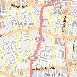
via kindle-maps.com
OpenStreetMap in multi-modal trip planner study

OpenStreetMap contributor, Ed Hillsman, was the senior research
associate on a multi-modal trip planner study. In it the authors
implement a multi-modal trip planner using transit feeds,
OpenStreetMap data and a variety of Open Source tools. Join me in
reading this weighty tome. My quick first glance suggests that it
will be well worth reading the full report.
OpenStreetMap OpenID now open

OpenStreetMap now allows accounts to be authenticated with OpenID as
an additional, optional authentication method for some OSM functions.
You may ignore this if you are not interested in OpenID. Some users
find OpenID an interesting way to reduce the number of passwords they
have to use in their travels on the internet.
If you have an existing OpenID or wish to create an OPenID for use
with OpenStreetMap, have a look at the OSM OpenID page on the wiki for important caveats.
Both Kai and Tom were key in
writing and implementing these improvements. Be sure to thank them if
you like OPenID. Perhaps buy them a beverage when you see them.