Weekly OSM Summary #38

February 27th, 2012 – March 12th, 2012

A summary of all the things happening in the OpenStreetMap (OSM) world.

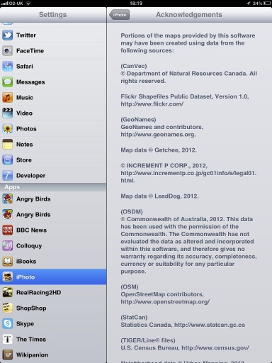
  • Foursquare switched to OSM. Some additional thoughts on that topic in a blog post by Andrew Turner. Also, Apple iPhoto uses some “old” OSM data now too. Read more about it in the OSM Foundation blog.
  • The new OSM Foundation (OSMF) servers are up and running. Also, say welcome to the two new system admins: Ian Dees and Sarah Hofmann!
  • Simon’s Cleanmap, which can be used for the remapping process, has a new layer “UNDELETE_IT”. You can find some more information here.
  • The OSM Inspector License View now supports Relations too. Here is the announcement.
  • An article about the Humanitarian OSM Team (HOT) in Indonesia.
  • On OSMstats you can find new statistics for “Edits Per Country“.
  • MapBox.com offers a new mapstyle called “Streets” with global coverage based on OSM data.
  • The “LightMap” created by the University of Heidelberg is a transparent overlay which highlights streets that include street lights. A second layer shows the type of street light.
  • The Open Mapquest Map has been updated. For instance, street signs are now included.
  • A tutorial by Till Nagel about “TileMill for Processing“.
  • mapbook: a PDF map book creator” which uses the mapnik renderer.
  • The Overpass API now supports permanent IDs to OSM objects.
  • A new Open Source framework to create vector maps: Kartograph
  • A new rule-based OSM renderer called “Smrender” has been officially released.
  • Jochen Topf released a new tool to extract coastline data from an OSM planet file.

Did we miss something? You can contact us via weekly.osm@googlemail.com

Authors: Pascal & Dennis – (thx @ “Wochennotiz”)

OSM database downtime 20 March 2012

On Tuesday 20th of March 2012 between 13:45 and 16:15 (GMT / UTC) the
primary database server will unavailable due to emergency maintenance.

The following services WILL be affected:
* www.openstreetmap.org web site will not allow user login or edits
(Potlatch). [1]
* API and map database editing (using JOSM, Merkaartor etc.) will be
unavailable.
* planet.openstreetmap.org will be available but no new diffs will be
generated during the outage.
* Forum (no logins)
* trac (bug-tracker, no logins)
* help.openstreetmap.org (no logins)

Other services will NOT be affected – all of the following are
expected to function normally:
* tile serving (“View The Map” & “Export”)
* Wiki
* Nominatim (search)
* mailing lists
* subversion and git (source code repositories)
* donate.openstreetmap.org

Technical: Database Server Smaug: Replacing faulty motherboard.
Supplier Engineer Onsite. We have contingency hardware available.

1: Maps will still be viewable on the openstreetmap.org homepage and
on other people’s websites.

Sincerely
Grant Slater
On behalf of the OpenStreetMap sysadmin team

Database downtime – 20 March 2012

On Tuesday 20th of March 2012 between 13:45 and 16:15 (GMT / UTC) the
primary database server will unavailable due to emergency maintenance.

The following services will be affected:

  • www.openstreetmap.org web site will not allow user login or edits (Potlatch). [1]
  • API and map database editing (using JOSM, Merkaartor etc.) will be unavailable.
  • planet.openstreetmap.org will be available but no new diffs will be generated during the outage.
  • Forum (no logins)
  • trac (bug-tracker, no logins)
  • help.openstreetmap.org (no logins)

Other services will not be affected – all of the following are
expected to function normally:

  • tile serving (“View The Map” & “Export”)
  • Wiki
  • Nominatim (search)
  • mailing lists
  • subversion and git (source code repositories)
  • donate.openstreetmap.org

Technical: Database Server Smaug: Replacing faulty motherboard.
Supplier Engineer Onsite. We have contingency hardware available.

1: Maps will still be viewable on the openstreetmap.org homepage and
on other people’s websites.

Sincerely
Grant Slater
On behalf of the OpenStreetMap sysadmin team

New imagery for Australia

Grant has done some work to make new imagery available for Australia. It’s grayscale imagery for all of Australia at 2.5 metre resolution.

AGRI imagery zoomed out

Read more about this on the talk-au mailing list, and load the imagery into your editor as follows:

JOSM tms url: tms:http://agri.openstreetmap.org/{zoom}/{x}/{y}.png (or just pick it from the ‘available default entries’)

Potlatch background url (Background > Edit> Add): http://agri.openstreetmap.org/$z/$x/$y.png (It will be added to Potlatch imagery default in a few days.)

Welcome, Apple!

Yesterday Apple launched iPhoto, its photo management app, for the iPad and iPhone… and we’re rather pleased to find they’re the latest to switch to OpenStreetMap.

The desktop version of iPhoto, and indeed all of Apple’s iOS apps until now, use Google Maps. The new iPhoto for iOS, however, uses Apple’s own map tiles – made from OpenStreetMap data (outside the US).

If you don’t have iPhoto, you can view the maps using this unofficial viewer  from Dair Grant or a transparent comparison from Iván Sánchez.

The OSM data that Apple is using is rather old (start of April 2010) so don’t expect to see your latest and greatest updates on there. It’s also missing the necessary credit to OpenStreetMap’s contributors; we look forward to working with Apple to get that on there.

03 May 2012 Update: Apple appear to have added OpenStreetMap attribution in their iPhoto v 1.0.1

But we’re delighted to see another prominent map user make the switch to OpenStreetMap, and look forward to many more.

OSMF Hardware Update

Servers, ramoth and bowser, in position.

The sysadmin team have brought some more hardware on-line for our delight. OpenStreetMap servers are named after dragons, taken from “Here be Dragons” the inscription denoting incomplete / unexplored places on historical maps. Learn more about OpenStreetMap dragons.

  • azure – Java-XAPI. Experimental. Provides read-only OSM data from a refreshed XAPI code base. Azure has recently received a long anticipated disk upgrade.
  • bowser – joins soup and fiddlestick as another Web Front End server. This server will make browsing the osm.org web site snappier for browsing the map, etc.
  • eustace – Web stats. Experimental. Tracks user behaviour across OSM servers to understand and improve user experience.
  • gorwen and orm –geoDNS tile caching. gorwen is kindly supplied and hosted by Teleservice Skåne AB GeoDNS serves tiles from the closest tile server. The sysadmin team hope to have a North American server available shortly. We seek a host for other, geographically diverse servers. If you are interested and not worried by 100Mbits/s, please speak to a sysadmin on #osm-dev at http://irc.osm.org
  • poldi – Nominatim. Provides search and geocoding of OSM data. Return of a local nominatim instance after a hiatus.
  • ramoth – is the second database server. The successful fund raising campaign of December 2011 led to the installation of this server. This server increases the reliability and performance of OSM database operations. Current status: in rack, being configured.

We also welcome the two newest members of the server team, Ian Dees (iandees) and Sarah Hoffman (lonvia). They will be maintaining the Java-XAPI and nominatim servers.

Photo credit

Photo by Firefishy.

Weekly OSM Summary #37

February 13th, 2012 – February 27th, 2012

A summary of all the things happening in the OpenStreetMap (OSM) world.

  • The State of the Map (SotM) 2012, held in Japan, needs a logo.
  • A blog post about the switch of geochaching.com from Google to OSM.
  • The Guardian published an article titled „OpenStreetMap: ‘It’s the Wikipedia of maps’“ as part of the „Britain’s 50 new radicals“ series.
  • The websites of the European Union are recommending OSM as a webmap.
  • An new analysis by Martijn about the State of the OSM Road Network in the US can be found here.
  • The Humanitarian OSM Team (HOT) is looking for help to create a creole OSM-Book in Haiti.
  • Version 0.3 of the Leaflet JavaScript library for interactive maps has been published.
  • A python module implementing the Overpass API for OSM map data queries.
  • A new map for on the road showing hotels, camping areas and other useful information.
  • An OSM map with ASTER hillshading (30m raster) of the University of Heidelberg.
  • The open source tool Freemind allows the integration of geo-positions and OSM maps now.
  • A new open source tool termed OSM Explorer allows rendering and routing on Windows.
  • SteveC initiated a new project: opengeocoder.net
  • A Youtube video about a mapping party in Russia can be found here.

Did we miss something? You can contact us via weekly.osm@googlemail.com

Authors: Pascal & Dennis – (thx @ “Wochennotiz”)

Foursquare chooses OpenStreetMap

The social location check-ins application FourSquare has 15 million
users worldwide, and now they are using OpenStreetMap! The foursquare
website now features lovely custom rendered OpenStreetMap maps.

We ultimately ended up switching because, after all our
research and testing, OpenStreetMap and MapBox was simply the best fit
for us

http://blog.foursquare.com/2012/02/29/foursquare-is-joining-the-openstreetmap…

This will surely be a great boost to OpenStreetMap contribution too,
as people spot areas where the map needs to be improved. Foursquare
users, welcome to the OpenStreetMap community.

Help find who killed Ulf

We had sad news in January that our friend Ulf had been murdered in
Germany. Ulf’s family have asked if we can help find those who
murdered Ulf? Please see the up-to-date reports, and photos of
suspects:

http://ulf-m.blogspot.com

And please circulate. Help find Ulf’s killer(s).

We’re asking for the OSM community’s help. The people who
killed Ulf haven’t been found yet, very probably because they left the
country the morning after the crime. East European mappers, especially
from Lithuania or Poland, might have seen them, or they might at least
know about message boards in their language where the pictures and
description can be posted.

At http://ulf-m.blogspot.com, there are now English, Lithuanian and
Russian language versions, a Polish Version will follow. We are
thankful for any help in circulating our appeal in any appropriate
form.

Weekly OSM Summary #36

January 30th, 2012 – February 13th, 2012

A summary of all the things happening in the OpenStreetMap (OSM) world.

  • The “License Change View” of the OSM Inspector is updated every four hours now.
  • Several OSM Users reported that the Bing aerial imagery has been updated or that new images have been added. Read more here.
  • OSM data and Garmin GPS Maps for Syria generated on an hourly basis are available now. Based on the Bing aerial imagery you can add missing streets.
  • A Hack Weekend will take place in March in Toronto. Get more information here.
  • Belarus has a new OSM Project page now too: openstreetmap.by
  • Some OSM users noticed that several military areas in Germany are now masked in the German Bing aerial images. According to Steve Coast, a German agency requested this.
  • The Tiles @ Home server will be shut down by the end of February 2012. A big thank you for hosting this service in the past! Read the full announcement here.
  • A new JOSM-Plugin speeds up the download time of OSM data. Read more about it here.
  • On OSMRanking you can create daily updated rankings based on your edits in the OSM database. You can find an example of the “Members of the OSM Foundation Board” here.
  • Steve Kay created an OSM Tag Network of Edinburgh.
  • Lanyrd.com shows upcoming events on an OSM Map now. For instance the German FOSSGIS & OSM Conference 2012 in Dessau
  • With Active.com and Toursprung two additional websites switched from Google to OpenStreetMap.
  • A video of Patrick Meier’s presentation about “Crisismapping” at the re:publica XI: “Changing the World, One Map at a Time“. Also, a video of a presentation by Richard Cantwell at the Ignite Dublin about OSM and in particular about Haiti can be found here.
  • Around the Alps in 80 days“ a mapping project for the summer of 2012.
  • A nice Blog Post about “OpenStreetMap Philippines: 2011 Year in Review” by Eugene Alvin Villar.
  • An iOS App for OpenSeaMap is available now.

Did we miss something? You can contact us via weekly.osm@googlemail.com

Authors: Pascal & Dennis – (thx @ “Wochennotiz”)