We’re in The Guardian Technology Section today!
LinuxTAG
One of the best things about openstreetmap is that I havn’t got a clue what everyone does any more. Once upon a time I knew everyone involved but now with over 1800 users things are just too big. Sxpert put an underground OSM demo at the X.org stand at LinuxTAG, you can see pictures here. I wonder if Matt realised his logo would show up all over the place. The tag line is very nice ‘free map data for a free world’.
Ticket to Ryde

The Isle of Wight workshop is now over and most of us have travelled back nursing sores from punching those tiny GPS buttons all day. It was a great success, with over 30 people turning up. Friday started for David Groom and I by doing an interview for solent tv which can be downloaded here. The main event started with an extended BBQ on the beach on Friday night as people arrived with food, beer and parsnip crisps Stone Soup style. This carried on late in to the night and involved building a bonfire out of drift wood, getting carried away and trying to cook bananas.

Retreating to caravans and cottages, the next day was planned over donuts. We met in the morning at the Riverside Center in Newport and roughly divided up the Isle in to parts for people to map with much self-organisation. Everyone departed on foot, by car or cycling with GPS and methods of noting features like streets – camera, notebook or dictaphone. Those at HQ changed camp to the Quay Arts Center which provided much needed wifi.

SA Mathieson came to talk to us for (hopefully) a piece in this Thursday’s Guardian. The MP for the Isle of Wight, Andrew Turner, came and saw what we were doing. Being an ex-geography teacher he was interested, and the local press came along to snap some pictures too.
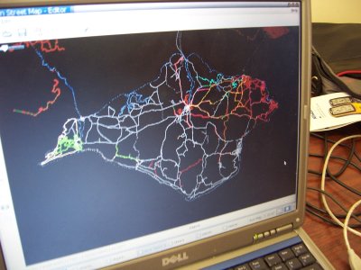
Sunday began by collating all the tracks together and deciding where next to map. The picture shows what we had, and it was impressive for one days work. Based on this, people departed to continue mapping but most came back for a late lunch together before sailing home.

But the best is yet to come! The traces will now be turned in to animations, posters and of course, a map!
New Statesman Awards
Both this blog and openstreetmap have been nominated for the New Statesman New Media Awards, which is nice!
Weighted Car
This is a pic of Nick Hill’s car after being loaded with servers, rack cabinets and stuff. It took hours of work, and Nick drilled out some rivets to take the cabinet apart. Currently we’re waiting on the official green light on hosting, at which point all this stuff will get installed.

Podcast: Nick Hill
Nick and I spent a day tearing apart donated computers and racks last week and afterward ended up in a pub. We talked about openstreetmap and how he’s getting data in there. Here is an 11 meg mp3 which lasts 25 minutes. Again, if you subscribe to the RSS feed in iTunes etc then you’ll magically get the audio in your iPod. Enjoy!
Old Maps, Aerial Photographs and Experimental Derives
Richard picks out a great Guy Debord quote in his review of Simon Sadler’s The Situationist City. I’ve found a longer version of the quote which I’ll reproduce for posterity here:
“With the aid of old maps, aerial photographs and experimental derives, one can draw up hitherto lacking maps of influence, maps whose inevitable imprecision at this early stage is not worse than that of the first navigational charts; the only difference is that it is a matter no longer of precisely delineating stable continents, but of changing architecture and urbanism.”
Fantastically resonant, that.
— Tom
SVG Map of Sutton Coldfield
Andy Robinson has produced a large and featureful SVG map of Sutton Coldfield using the aforementioned Osmarender and OpenStreetMap.
Click the image below to get an idea of how far we’ve come, and see Andy’s entry on the OpenStreetMap wiki for a link to the SVG version and more about how it was made.

— Tom
Google Maps vs Mapstraction, pt II
This was going to be part of an earlier post, but should now stand alone.
When we’re not working on free geodata creation for OpenStreetMap, we like to make the best of the current free beer commercial mapping APIs to make neat things like GPX viewers and pub maps. In the light of some of the more amazing Google Maps mashups out there (here’s a recent decent), these sites might seem underwhelming, but if you consider how quickly they could (or couldn’t) have been put together a year ago then it’s clear that thanks to Google Maps we’ve come a very long way.
Tim O’Reilly recently asked the Mapping Hacks people, and others, why Google Maps was so much more popular than all the other APIs available. Schuyler pretty much nailed it, though after my Mapstraction research I think he’s too generous towards Yahoo and Microsoft.
I note with disappointment that neither Yahoo nor MS offer polyline support, which leaves my desired cross-vendor demo of a GPX viewer dead in the water. It also means that anyone requiring that functionality for drawing routes or boundaries is stuck with Google for the time being. Ironically for Google however, their recently developed open source Explorer Canvas might offer a cross-platform way for Y! and MS to compensate for this. Further disappointment with alternatives to Google Maps comes with the realisation that Yahoo’s maps only cover North America so far (although I was pleasantly surprised to find Microsoft is the only provider to give any road or placename data outside of North America, UK and Japan).
Microsoft’s Virtual Earth SDK feels clunky to code with, shirking the fashionable javascript idioms which help make Yahoo and Google‘s offerings feel elegant, and their API is completely malnourished with regards to easily placing nice looking map pins. Sure, it might be flexible, but Google and Yahoo’s offerings look good out of the box which is really important. (The same can be said of the developer documentation, too).
Whilst looking at all of this I took a look at OpenStreetMap’s slippy maps interface to see if I could allow plotting of pins. Unfortunately, although the Civicmaps code base we started with supports plotting GeoRSS, it looks like in the process of adding in support for Mercator projection that the marker features were broken. This means that for an OpenStreetMap-powered javascript maps implementation you can put on any website, there is still lots of work to do. However, following this exercise I’ve discovered that if anyone wants to seriously compete with Google in this space, then we all have a lot of catching up to do too!
— Tom
SVG Output Update
The SVG output we demonstrated a while ago continues to be improved in the form of Osmarender. With the right pieces of sticky-tape and string, there is now an end-to-end solution at openstreetmap.org for taking GPS traces and converting them into pretty maps with street names and place names. A big step forward, well done to all who contributed.
— Tom