UPDATED Flame in person in the relaxed atmosphere of a pub at OSM’s 2nd anniversary party. Argue the finer points of GPS devices. Find out what people look like.
Where: Porter House, Covent Garden
When: Saturday 12th August, 1:30pm onward
UPDATED Flame in person in the relaxed atmosphere of a pub at OSM’s 2nd anniversary party. Argue the finer points of GPS devices. Find out what people look like.
Where: Porter House, Covent Garden
When: Saturday 12th August, 1:30pm onward
Richard picks out a great Guy Debord quote in his review of Simon Sadler’s The Situationist City. I’ve found a longer version of the quote which I’ll reproduce for posterity here:
“With the aid of old maps, aerial photographs and experimental derives, one can draw up hitherto lacking maps of influence, maps whose inevitable imprecision at this early stage is not worse than that of the first navigational charts; the only difference is that it is a matter no longer of precisely delineating stable continents, but of changing architecture and urbanism.”
Fantastically resonant, that.
— Tom
Andy Robinson has produced a large and featureful SVG map of Sutton Coldfield using the aforementioned Osmarender and OpenStreetMap.
Click the image below to get an idea of how far we’ve come, and see Andy’s entry on the OpenStreetMap wiki for a link to the SVG version and more about how it was made.

— Tom
This was going to be part of an earlier post, but should now stand alone.
When we’re not working on free geodata creation for OpenStreetMap, we like to make the best of the current free beer commercial mapping APIs to make neat things like GPX viewers and pub maps. In the light of some of the more amazing Google Maps mashups out there (here’s a recent decent), these sites might seem underwhelming, but if you consider how quickly they could (or couldn’t) have been put together a year ago then it’s clear that thanks to Google Maps we’ve come a very long way.
Tim O’Reilly recently asked the Mapping Hacks people, and others, why Google Maps was so much more popular than all the other APIs available. Schuyler pretty much nailed it, though after my Mapstraction research I think he’s too generous towards Yahoo and Microsoft.
I note with disappointment that neither Yahoo nor MS offer polyline support, which leaves my desired cross-vendor demo of a GPX viewer dead in the water. It also means that anyone requiring that functionality for drawing routes or boundaries is stuck with Google for the time being. Ironically for Google however, their recently developed open source Explorer Canvas might offer a cross-platform way for Y! and MS to compensate for this. Further disappointment with alternatives to Google Maps comes with the realisation that Yahoo’s maps only cover North America so far (although I was pleasantly surprised to find Microsoft is the only provider to give any road or placename data outside of North America, UK and Japan).
Microsoft’s Virtual Earth SDK feels clunky to code with, shirking the fashionable javascript idioms which help make Yahoo and Google‘s offerings feel elegant, and their API is completely malnourished with regards to easily placing nice looking map pins. Sure, it might be flexible, but Google and Yahoo’s offerings look good out of the box which is really important. (The same can be said of the developer documentation, too).
Whilst looking at all of this I took a look at OpenStreetMap’s slippy maps interface to see if I could allow plotting of pins. Unfortunately, although the Civicmaps code base we started with supports plotting GeoRSS, it looks like in the process of adding in support for Mercator projection that the marker features were broken. This means that for an OpenStreetMap-powered javascript maps implementation you can put on any website, there is still lots of work to do. However, following this exercise I’ve discovered that if anyone wants to seriously compete with Google in this space, then we all have a lot of catching up to do too!
— Tom
The SVG output we demonstrated a while ago continues to be improved in the form of Osmarender. With the right pieces of sticky-tape and string, there is now an end-to-end solution at openstreetmap.org for taking GPS traces and converting them into pretty maps with street names and place names. A big step forward, well done to all who contributed.
— Tom
When I first got involved with OpenStreetMap, my aspiration was to make free maps to enable something like Wayfaring or Platial to be built. Even though those sites and many others are storming ahead without us and creating great services on top of Google’s Maps API, I still think it’s important for them to be able to access and build upon free geodata and avoid lock-in with commercial vendors. This is especially important for sites like Placeopedia that use Google Maps to geo-code things, because as Mikel Maron and Richard Fairhurst have pointed out (see the comments) it’s entirely possible that the map owners could claim ownership of the geodata they are creating.
With all that in mind, I took a look at what could be done to make it as easy as possible to switch mapping providers. In the short term, this would mean making it easy to flip between Google Maps, Yahoo Maps and Microsoft Virtual Earth in response to changes to T&Cs, introduction of ads, addition of better data etc. In the long term, a common javascript mapping API would mean that free offerings such as OpenStreetMap or Worldkit could quickly be adapted as drop-in replacements for commercial providers. I’ve been collecting my thoughts on this at Mapstraction.com/wiki based on discussions with Steve and Mikel, and there’s an illustration of how it might work here.
I’m not the only one thinking along these lines, of course. The Open Source Geospatial Foundation has a cross-project mailing list for people interested in similar issues, and numerous hacks and comparisons abound as people work out how similar but different the various mapping platforms are. Hackers everywhere have been murmuring about their dependence on Google for some time, and maps aren’t the first area where Google’s initial offering invites obvious commoditisation.
Looking at the common features of the mapping APIs, it’s clear that the bar is currently set quite low: it’s scrolling tile-based maps with map markers, folks. With tongue in cheek, Schuyler Erle refers to this as “red dot fever” (more context here, though I don’t know if that’s Schuyler’s writing or a like-minded collaborator). Numerous open source equivalents have emerged, but none has taken hold to my knowledge. This cements the general feeling among the responses to Tim O’Reilly’s open question about Google’s Mapping API dominance: Google Maps is actually very good, it was first to market, its maps look nicest, its terms and conditions are reasonable and as a developer it’s pretty easy to work with. It’s clear to us that OpenStreetMap has a lot of catching up to do, but it’s also become clear to me that Yahoo and Microsoft do too. I’m watching this space.
OpenStreetMap contributor Etienne Cherdlu (aka 80n) has been working on converting the OpenStreetMap API output into SVG using XSL tranforms. So far so good!
The projection on this example is only really suitable for Etienne’s area of interest, but this gives a good example of where we’ll be headed for the Isle of Wight workshop, and shows what is possible right now using OpenStreetMap tools and a little bit of hard work. Thanks Etienne!
Etienne Cherdlu writes:
I’m pleased to announce that the main carriageways of all mainland UK motorways have been completed. Over 3,000 km of roadway.
This does not include motorways in Northern Ireland nor does it include motorway sections of A roads, so there is still plenty of work to do.
Indeed, the user contributions are now outstripping the current editing software! In the works is functionality to classify the motorways so they can be rendered more effectively in our map drawing software and used effectively in any future routing algorithms.
Still, this is an excellent result, well done to the UK Motorways team, who could still use your help in adding/refining junctions and checking for consistency.
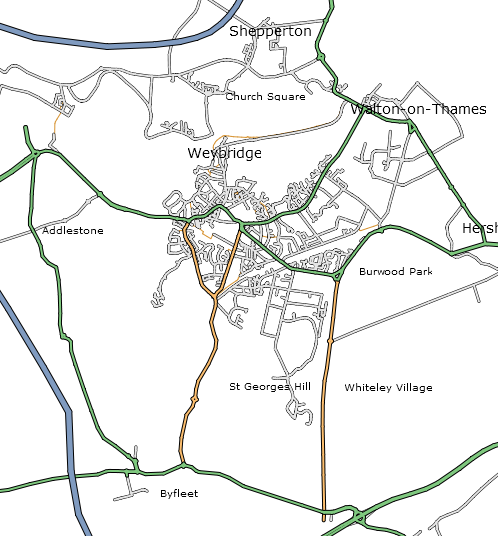
In other news, OpenStreetMap gained it’s 1000th registered user just before the new year.
OpenStreetMap has contributors all over the world, and our biggest UK contributor is London-based courier firm eCourier. They kindly provide us with GPS data collected by their couriers, and when you edit a part of London it’s almost certainly thanks to them that the roads are so clear and easy to trace.
We made a short animation to illustrate a sample of their data which they are hosting here, and you can check out their site and read more about our collaboration on their news page.
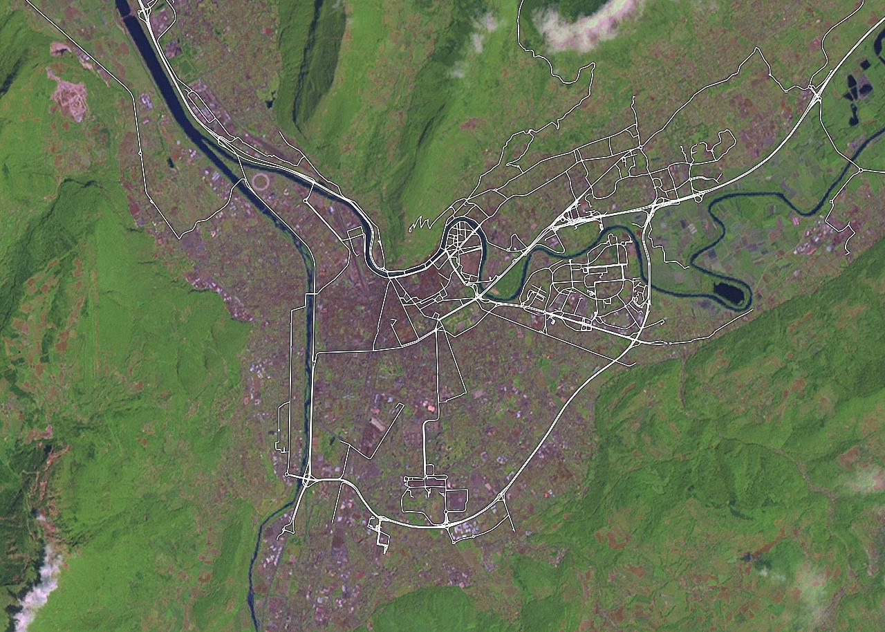
I remembered my favourite town so far in OpenStreetMap, it’s Grenoble in France. Again, the product of dedicated hands unknown, this time it’s worth clicking in for a closer look…