It’s now live, with a big plug up front for the upcoming SOTM conference!
Jog mapping
“You can work out by chopping wood, carry things, cycle to work, etc. In Klæbu I found another way: Jog to make maps!”
http://www.google.com/buzz/dittaeva/eX93k8w7sV5/Jog-mapping-the-productive-wa…
Eddy’s Sofa And The Nightmare Of A Single Global Places Register
“Eddies,” said Ford, “in the space-time continuum.” “Ah,” nodded Arthur, “is he? Is he?”
“What?” said Ford. “Er, who,” said Arthur, “is Eddy, then, exactly, then?”
…
Why,” he said, “is there a sofa in that field?”
“I told you!” shouted Ford, leaping to his feet. “Eddies in the space-time continuum!”
“And this is his sofa, is it?” asked Arthur, struggling to his feet and, he hoped, though not very optimistically, to his senses.
Jump onto Eddy’s sofa for a moment and fast forward to a possible 2015.
After the location wars of 2010, the problems of mutually incompatible geographic identifiers have been solved with the formation of the Global Places Register. Founded by a fledgling startup on the outskirts of Bangalore, the GPR offered an open and free way for individuals and corporations to add their town, their business, their POI. All places added became part of the Global Places Translator, allowing Yahoo’s WOEIDs to be transformed into OpenStreetMap Ways, into long/lat centroids, into GeoNames ids or even, for the nostalgic, Eastings and Northings.


With this thorny problem solved, location issues became a thing of the past, no one used the phrase ubiquitous location any more and location really was a key context.
Until 2014 when, inspired by the move from CDDB to Gracenote, Global Places Pty Ltd promptly ringfenced the entire database under a commercial license and added a mandatory application id to all their APIs. An application id that cost a lot of money in licensing.
Of course, the fact that the GPR was now the sole global source of places doesn’t mean that it’s complete or authoritative. Being controlled by a single corporation, the GPR is an easy and obvious target for hacking and litigation. A dedicated team spends all their time removing places and POIs from the register that have offensive or religious connotations, either as a result of user generated contributions or malicious hacking.
Sadly, the cities of London in Ontario and Ohio are no longer found in the GPR; they’ve had to rename themselves after a successful trademark and copyright case brought by London in the United Kingdom, which is now the sole place in the world allowed to call itself by that name. This does make geodisambiguation a bit easier though.
Likewise, you won’t find any newsagent or newsstand POIs in the GPR; they were all removed following a successful DMCA takedown by the League of Concerned Conservative Fundamentalist Parents, who didn’t want their precious offspring to be able to locate purveyors of potentially offensive adult material on their GPR powered LBS apps on their Android mobile internet tablets.
The same goes for any business with the word jolly in it; they were all removed and forced to rebrand following the success of Jolly Jet trademarking the word jolly and then pursuing an aggressive litigation program against any business unfortunate enough to have that word as part of their name.
This is all just a geographical bad dream. It’s not real. Wake up. Back to 2010 now, safe and secure in the knowledge that this could never happen …
Yet there is a growing clarion call for an open global database of places, POIs and business listings that will allow all of the disparate geographic identifier systems to be rationalised and used interchangeably. It’s the problem of what I’ve started calling GeoBabel but an actual global database of places isn’t the solution to this problem.
State of the Map 2010 – Schedules announced

I know that you have been waiting to see the schedule for State of the
Map 2010. And now I know that you will love it. The SotM team has
done a spectacular job of soliciting and acquiring a great line-up of
speakers and topics. You will want to buy your ticket and book your
trip now. http://stateofthemap.org/register-now/
Day One: Business and Workshop Day
Friday http://stateofthemap.org/schedules/friday/
Day Two: Community, Tech, Quality and Scholarship Tracks
Saturday http://stateofthemap.org/schedules/saturday/
Day Three: Tools, Imports, Humanitarian and Cartography Tracks
Sunday http://stateofthemap.org/schedules/sunday
One sign of an excellent conference program is having too many hard
choices between concurrent sessions. This schedule passes that test.
I’ve made many decisions on which talk I’ll attend, but others I’ll
have to decide at the last minute. This is a conference not to be
missed.
State of the Map 2010 – Sponsor update
A couple of additional sponsors have confirmed their return appearance
for State of the Map 2010! Both of these companies are supporting
State of the Map at the Silver sponsorship level.
Returning from sponsoring in 2009:

Curly Brackets http://curlybrackets.de/
Returning to sponsor SotM for the third consecutive year:

ITO World http://www.itoworld.com/
There are still a few sponsorship spots available. Act now to meet and
greet with a wide cross-section of the movers and shakers of the
OpenStreetMap community.
Image of the Week: OSM data on a train
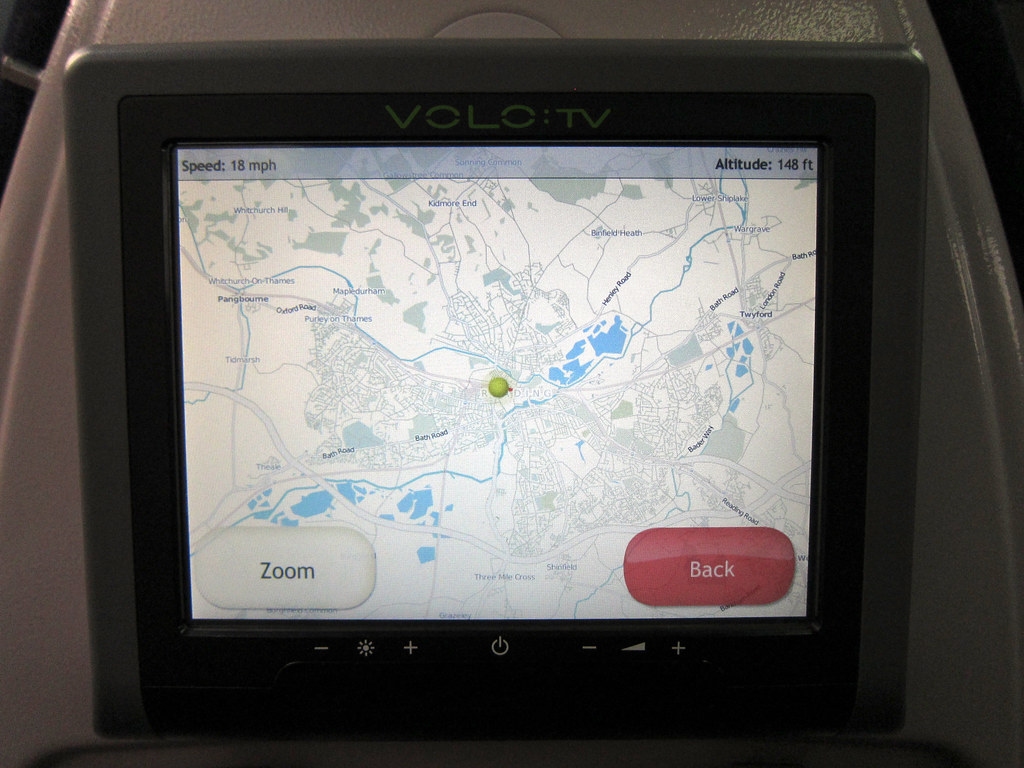
From Simon Clayson’s Flickr stream, we learn:
Great Western Trains have some seats with airline style LCD
“entertainment” screens. More interesting than paying £1.50 to watch
an episode of Friends is the “You are exactly here” screen which is
free. And it uses Open Street Map! Good work Volo TV.
Simon also tells us that the maps are attributed. He says, There’s
a big notice as you arrive on the page that thanks the “Contributors
of OpenStreetMap”
Photo of OSM map on VOLO:TV by Simon Clayson.
http://www.flickr.com/photos/claypole/
The photo is licensed cc-nc-nd
http://creativecommons.org/licenses/by-nc-nd/2.0/deed.en
OSM HeatMaps in the browser w/ OpenLayers
[youtube http://www.youtube.com/watch?v=917EeJowMhs?wmode=transparent]
Felipe Barriga Richards writes on his blog:
After been working sometime with OpenLayers I figure out
how to make heatmaps generated in the user browser. Now I’m using
OpenStreetMap for both map and data.
Another wonderful tool building upon the wonderful tool that is
OpenLayers. http://openlayers.org/
I can’t wait until Felipe releases his code so I can try this myself.
See the rest of Felipe’s article and more demonstration videos at:
http://blog.felipebarriga.cl/programacion/openstreetmap-heatmap-using-openlay…
Icons for data browser pages

Dan Karran http://twitter.com/dankarran notes an improvement in OSM.
I posted a while back about some tinkering I’d been doing
with the OpenStreetMap data browser pages, adding icons to nodes and
ways when they’re shown in a list. I’m happy to see that TomH has now
pushed those changes live.
Nice one, Dan!
See more of what Dan had to say in his post
http://www.openstreetmap.org/user/dankarran/diary/10695
OpenStreetBugs

There are bugs everywhere. There are even some errors in OpenStreetMap
data. OpenStreetBugs is a site that allow folks to quickly report a
problem with or question about specific OSM data.
http://openstreetbugs.schokokeks.org/ Have a look at OpenStreetBugs
near you and help clear some of the existing bugs by helping the
reporter with a tagging problem, or visiting the site for a quick
survey and re-tagging.
Geo tshirts – where are they now?
I’m clearing out the geo tshirts, and took a goodbye photo:
http://www.flickr.com/photos/stevecoast/4608208984/
I’ve tagged the best I can. A lot of water under the bridge.