Monthly Archives: August 2020

Active OSM contributor? You can now easily join the OpenStreetMap Foundation

Deutsch Français Galego Polski Nederlands Русский
Map data by OpenStreetMap Contributors. Official OSM logo by Ken Vermette, CC-BY-SA 3.0 & trademarks apply. Image by D.Kazazi CC BY-SA 2.0

If you contribute significantly to the OpenStreetMap project you should have a voice in the OpenStreetMap Foundation, which is supporting the project, and be able to vote for the board members of your choice. There is now an easier and costless way to become an OpenStreetMap Foundation member:

The volunteers of the OSMF Membership Working Group have just implemented the active contributor membership program, where you can easily apply to become an Associate member of the Foundation and there is no need to pay the membership fee.

What can I do as an OSMF Associate member?

  • You can vote for the board candidates of your choice at the board elections.
  • You can vote on some issues during General Meetings (but not all).
  • You can participate in the discussions between members on the OSMF members mailing list (if you are already an OSMF member register here – see the archive available to all).
    • Subscription to the mailing list is optional.
    • You have the option to receive a single daily digest, containing all the emails of the day.
    • Feel free to email in your language 🙂
  • You can proudly say that you are an OSMF member 🙂

How does it work?

We will automatically grant associate memberships to mappers who request it and who have contributed at least 42 calendar days in the last year (365 days).

Not everyone contributes by mapping, and some of the most familiar names in our members list barely map. Some are very involved, for example, in organizing conferences. Those other forms of contribution should be recognised as well. If you do not map at all or less than the 42 days, then we expect you to write a paragraph or two about what you do for OpenStreetMap. The Board will then vote on your application.

How can I find out how many mapping days I have?

  • You can get an estimate from tools like Pascal Neis How did you contribute, which should be accurate enough for most purposes.
  • If you are technically versed and wish to verify your mapping days yourself, use the changesets API of OSM to query your changesets. Then you can collect all unique dates in the created_at attributes of the changesets, and count how many unique days you have in the last 365 days.

I would like to become a member via the active contributor program!

● If you qualify based on mapping activity (at least 42 mapping days in the last 365 days) please fill out this form to get your active contributor membership

● If you qualify for other contributions to OpenStreetMap please fill out this form and describe your activities to get your active contributor membership.
General link:
https://join.osmfoundation.org/active-contributor-membership/
Frequently asked questions

What do I need to supply?

  • Your name.
  • Your OSM username.
  • Your country of residence.
  • Your email address (where ballots for voting will be sent and will be the email address associated with participation in the OSMF members mailing list, if you choose to subscribe)

How long is this membership valid?

Just like paid membership, membership under the membership fee waiver programme must be renewed annually. You will get a reminder, and you then can request the renewal, similar to the initial application. The check for mapping at least 42 calendar days in the last year will be carried out at the time you request the renewal, or alternatively you submit again a paragraph or two about what you do for OpenStreetMap.

What else do I need to know?

By law, every member of the OSMF can inspect the membership register (we ask for the purpose before handing it out and generally distribution by the recipient is not allowed). Who joined under which program is not revealed. The name, country, email and one of the OSM account names will be shown.

Why does this active contributor membership program exist?

By inviting more active community members to join the OSMF, we become more resilient against take-over attempts through massive signups. We believe that even mappers for whom £15 is not a lot of money would be more willing to join, if they are invited to a free membership due to their good work. Also, active contribution to the project is easier to assess than financial hardship and does not require the applicant to disclose personal information. The potential loss of individual membership fee income is not a threat to our financial stability. In fact, there are quite a few members who like to donate more than just £15. Those donations need not be tied to any membership.

Why 42 mapping days?

Mapping days is not perfect, but we need a benchmark that is objective, easy to verify, and simple for us to measure and implement.
Why 42 days? If we measure contributions in mapping days by OSMF members who map (83%), roughly half of them map more than 42 days per year. We would expect a “slightly exceptional” contribution in terms of mapping days.

42

How are my changes divided into days for measuring 42 mapping days

For measuring the mapping days, the created at time stamp of each changeset is used. Typically, all changes in a change set have the same time stamp. A day is defined in UTC from midnight to midnight.

Does paid mapping count?

The “active contributor program” is there to measure your engagement towards the project. In the first place, we think this is shown by volunteer activities for the project. If you do organizing or mapping for OSM as a part of your paid job, that is not necessarily a show of engagement with the project. By default, we would not include these activities as qualifying for this type of membership. But feel free to explain your contributions, and the Board will have a vote.

Can’t this be cheated?

We also discussed abuse. When we receive an application, we contact the mentioned OpenStreetMap account(s) through the OSM messaging system to confirm they are owned by the applicant. You could of course make tiny contributions like wiggling a single node on 60 days, and maybe go undetected and get your membership. But that would be fraud, and the membership could be revoked if the OSMF Membership Working Group finds out that the contributions are not meaningful.


What happens to the old fee waiver program?

The Active contributor membership program is replacing the old “fee waiver” program (active from 2018 January onward) where the membership fee was waived in cases of financial hardship or lack of suitable money transfer ability. The change was made possible by a vote during the 2019 Annual General Meeting. The “financial hardship” and “Lack of suitable money transfer” rule will be dropped entirely because even today, we expect someone joining under those rules to demonstrate some sort of contribution, so they would likely be eligible under the new rule as well. 

What other options do I have to become a member?

As previously, you can still become a Normal member or Associate member of the Foundation by paying the annual £15 membership fee.

The main differences between Normal and Associate members are that:

  • Normal members have to supply their full residential address.
  • Normal members can vote on all issues during the General Meetings, while Associate members only on some issues.
  • Normal members can be board candidates and hence become board members.

You can switch your membership type. Please contact the Membership Working Group (email below) for more information.

OpenStreetMap logo with magnifying glass, showing stick figures.
Membership Working Group logo based on the official OSM logo by Ken Vermette, CC-BY-SA 3.0 & trademarks apply. Figures by Pascal Neis, reproduced with permission.

I would like to help the volunteers of the OSMF Membership Working Group!

Thank you 🙂 We need your help and you can make a difference by joining the Working Group. Send us an email at membership@osmfoundation.org

As a MWG member you can help us to:

  • Administer the membership register.
  • Answer routine questions like what kind of membership does someone have (normal or associate) or when will they need to renew.
  • Help with the manual work for matching bank transfers with memberships for new sign ups and renewals.
  • Sort out other problems regarding sign up or renewal.If you join, you can be as involved as you like.

I have another question!

Feel free to contact us at membership@osmfoundation.org

Cute half-blobs with eyes, holding sticks with maps.
Image by Tintao CC BY-SA 2.0, modified.

Get notified about new blogposts: Subscribe to the RSS feed!

Do you want to translate this and other blogposts in another language..? Please send an email to communication@osmfoundation.org with subject: Helping with translations in [language]

The OpenStreetMap Foundation is a not-for-profit organisation, formed to support the OpenStreetMap Project. It is dedicated to encouraging the growth, development and distribution of free geospatial data for anyone to use and share. The OpenStreetMap Foundation owns and maintains the infrastructure of the OpenStreetMap project, is financially supported by membership fees and donations, and organises the annual, international State of the Map conference. It has no full-time employees and it is supporting the OpenStreetMap project through the work of our volunteer Working Groups.
Continue reading

OSMF and Cesium joint press release: OpenStreetMap, a map of buildings!

Note: Cesium is a silver level corporate member of the OpenStreetMap Foundation, entitling them to this joint press release. If your organisation would like to support the OSMF more, please considering joining the OSMF as a corporate member, or read about other ways to give back.

Despite our project having “Street” in the name, there are 4 times as many buildings in OpenStreetMap as roads!

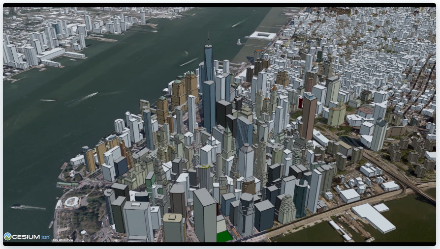
The newly released Cesium OSM Buildings from one of our newest corporate members Cesium is a global 3D building layer of more than 350 million 3D buildings derived entirely from OpenStreetMap. Cesium OSM Buildings is served as 3D Tiles, an open standard format for streaming 3D datasets, originally developed by Cesium.

Image © Cesium.

“OpenStreetMap has amazing 3D building data in cities around the world. It’s a testament to the skill and hard work of mappers in this community,” said Mikel Maron of the OpenStreetMap Foundation Board. “We appreciate Cesium’s support and advocacy of the project as a corporate member, and by adding OpenStreetMap data to their platform, they further advance our mission to ensure that OSM data is as widely used as possible.”

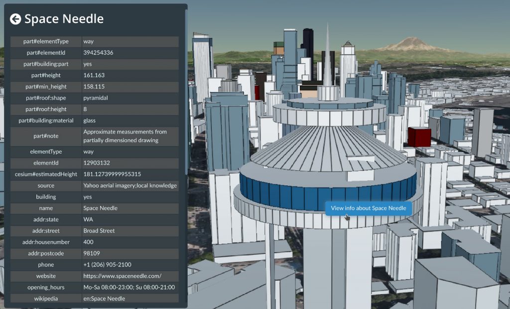
OpenStreetMap means rich metadata in most cities, like building name, address, and opening hours. Image © Cesium.

Cesium, which began as a project at an aerospace software company, has been maintaining its open-source virtual globe, CesiumJS, since 2011. CesiumJS recently surpassed 1 million downloads and its developer community has built thousands of applications in dozens of industries.

Cesium’s offering joins a vibrant community of projects which make use of building data from OSM. The OSM Buildings project is a free and open source web viewer for 3D buildings based on OSM. Open 3D rendering software based on OSM also exists for Blender, and in many other projects. OpenBuildingMap is a building focused window to OpenStreetMap, providing a filtered subset of OSM data with just the building data.

There are many tools for adding building data to OSM, from the popular building_tools and Kendzi3D plugins for JOSM, to StreetComplete, which helps our large contributing community survey building details. You can also read how buildings are mapped (“tagged”) in OSM. Our annual conference (State of the Map 2020), had a presentation on “Buildings are the new streets”.

OpenStreetMap – more than buildings
OpenStreetMap is a international project to create a free map of the world. To do so, we, thousands of volunteers, collect data about roads, railways, rivers, forests, playgrounds,
benches, fire hydrants and a lot more worldwide. Our map data can be downloaded for free by everyone and used for any purpose – including commercial usage. It is possible to produce your own maps which highlight certain features, to calculate routes etc. OpenStreetMap is increasingly used when one needs maps which can be very quickly, or easily, updated.

Proposal for Software Dispute Resolution Panel

Summary

Following community and membership consultations via the OSM-talk and OSMF-talk channels respectively, and in response to needs expressed by iD developers, the OSM Foundation Board proposes to create a small panel, the Software Dispute Resolution Panel (“Panel”), that will on request seek to resolve disputes that arise over features of the iD editor. Other OSM-related software products may also use this Panel if they choose to opt-in. We ask that comments on the proposal below be made on the OSM-talk mailing list (register to OSM-talk).

Background

Although relatively rare, compared to the total volume of updates, modifications, and enhancements made to the iD editor over time, such controversies as have arisen over changes to iD have threatened the project due to the emotional responses of some involved in the disputes. These controversies are undesirable and cannot be allowed to harm OSM or the OSM community. Hence, at the suggestion of iD developers, the OSM Foundation seeks a method of amicably resolving any disputes that may arise via a mechanism that is ultimately under the control of the OSM community.

Proposal

The OpenStreetMap Foundation (“Foundation”) Board will create a Software Dispute Resolution Panel (“Panel”) consisting of five members. Any Foundation member may be nominated to serve on the Panel. Self-nominations (volunteers) are specifically permitted. The Board will select five persons from among the nominees.

Initially, the Panel will deal solely with disputes over changes to the iD editor. If subsequently developers of other OSM-related software wish to use the Panel, they may request inclusion in the Panel’s remit. Opting into cooperation with the Panel is voluntary and will not, for example, factor into OSMF decisions related to funding.

Once a software product has been included in the Panel’s remit, the Panel shall be the venue for resolving disputes over that software without exception, that can not otherwise be resolved in the everyday discussion and governance of the project. Developers may request dispute resolution at any time. Members of the community may, after having made their issues known to the developers and working through their processes in good faith, request dispute resolution from the Panel. The Panel may decline to handle any requests where community discussion on the issue is still in progress, or requests that it deems abusive, repetitive, frivolous or spurious. Members may appeal to the OSMF board if they consider a resolution process was unjustly declined.

The Panel will be empowered to enlist assistance of subject-matter experts to study and resolve disputes, such as tagging presets. The Panel will examine all sides of any dispute and render a judgment. For tagging-related features, the Panel will advise against controversial presets or validation rules which are not based on sound and settled best practice. The panel will look at existing documentation, any recent community votes, usage numbers, and past discussions, and may convoke subject-matter experts. By having requested inclusion in the Panel’s remit, developers agree in advance to be bound by the Panel’s decisions.

Term of office

The term of office for members of the Panel shall be two years, except that in the first year of operation, two of the members shall have a term of office of one year. In this manner each year either two or three members of the panel will potentially turn over, allowing for some overlap and institutional memory. Members may be reappointed up to two times, but must step down after a maximum of three terms in a row, and may be reappointed after a one-term break.

Composition, conflicts of interest

Members of the panel must have a background as volunteer contributors to the OpenStreetMap project. In appointing members of the Panel, the Board shall strive for Panel composition (membership) that reflects all interests of the OSM community writ large. Members must not participate in cases involving software products developed, whether fully or partially, by employees of the same organization. Conflict-of-interest rules comparable to those for the OSMF board and working groups shall apply to the panel.

Transparency

Panel decisions will be recorded on the OSMF website, where the Panel will have its own page.

Evaluation

The decision to install the Panel will be evaluated by the Board and in public discussion among the Foundation’s members after one year.

Before installing the Panel, and as part of the evaluation at the one-year mark, the OSMF board will verify that existing working groups are not interested in adding this responsibility to their group’s scope.

Request for comments

We ask that comments be made on the OSM-talk mailing list (register to OSM-talk).

Allan Mustard
Chairperson, OSMF Board of Directors

Get notified about new blogposts: Subscribe to the RSS feed!

The OpenStreetMap Foundation is a not-for-profit organisation, formed to support the OpenStreetMap Project. It is dedicated to encouraging the growth, development and distribution of free geospatial data for anyone to use and share. The OpenStreetMap Foundation owns and maintains the infrastructure of the OpenStreetMap project, is financially supported by membership fees and donations, and organises the annual, international State of the Map conference. It has no full-time employees and it is supporting the OpenStreetMap project through the work of our volunteer Working Groups. Please consider becoming a member of the Foundation.
OpenStreetMap was founded in 2004 and is a international project to create a free map of the world. To do so, we, thousands of volunteers, collect data about roads, railways, rivers, forests, buildings and a lot more worldwide. Our map data can be downloaded for free by everyone and used for any purpose – including commercial usage. It is possible to produce your own maps which highlight certain features, to calculate routes etc. OpenStreetMap is increasingly used when one needs maps which can be very quickly, or easily, updated.

Celebrate the 16th OSM anniversary!

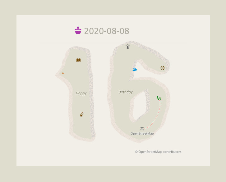
The 16th OpenStreetMap anniversary will be celebrated on the 8th of August, 2020! Image: Fictional map data rendered with the standard style of osm.org (osm-carto). CC-BY-SA 3.0, trademarks apply.

On Saturday, 8th of August 2020,
we will celebrate 16 years of OpenStreetMap!

Planning an online party or mapathon?

You can use the BigBlueButton video server of the OpenStreetMap Foundation! To get a free account and your own video room, please signup.

  • You can use your video room even after the birthday, for any OSM-related event.
  • Community members in low-bandwidth environments may benefit from using BigBlueButton’s low-bandwidth settings.
  • Please add your event to the OSM wiki! If wiki editing isn’t your thing, email communication@osmfoundation.org with your event details and we’ll add it 🙂

Other ideas

  • Post why you love OpenStreetMap. We will publish a collection of messages later 🙂
  • Post a photo of yourself holding a written message 🙂 
  • Use the hashtag #OpenStreetMap16 on social media
  • Make/order a birthday cake. See previous examples of OSM cakes for inspiration. Don’t forget the attribution!
  • If your photos are accompanied with the text “CC-BY-SA 2.0” (or another open license), we can add them to the OSM wiki (or feel free to add them yourself! ~ register here).
  • Do you have more ideas? Share them in the comments 🙂

Join us!

Observance of the anniversary of the creation of OpenStreetMap is held on or about the 9th of August, which is the anniversary of the registration of the OpenStreetMap.org domain name. The concept of OpenStreetMap predates the domain name registration, but that seems a suitable anniversary date 🙂

Get notified about new blogposts: Subscribe to the RSS feed!

Do you want to translate this and other blogposts in another language..? Please send an email to communication@osmfoundation.org with subject: Helping with translations in [language]

The OpenStreetMap Foundation is a not-for-profit organisation, formed to support the OpenStreetMap Project. It is dedicated to encouraging the growth, development and distribution of free geospatial data for anyone to use and share. The OpenStreetMap Foundation owns and maintains the infrastructure of the OpenStreetMap project, is financially supported by membership fees and donations, and organises the annual, international State of the Map conference. It has no full-time employees and it is supporting the OpenStreetMap project through the work of our volunteer Working Groups. Please consider becoming a member of the Foundation.
OpenStreetMap was founded in 2004 and is a international project to create a free map of the world. To do so, we, thousands of volunteers, collect data about roads, railways, rivers, forests, buildings and a lot more worldwide. Our map data can be downloaded for free by everyone and used for any purpose – including commercial usage. It is possible to produce your own maps which highlight certain features, to calculate routes etc. OpenStreetMap is increasingly used when one needs maps which can be very quickly, or easily, updated.