Today is International Day of Persons with Disabilities.
We’re gathering map data related to disabilities within OpenStreetMap, and because the map is openly editable, you can help!
Edit the map of your neighbourhood to add details on wheelchair accessibility, and the presence of things like tactile paving for blind people. Details of the world which we may not imagine to be important, can be very useful things when presented on a map to help people with a variety of disabilities. We have OpenStreetMap “tags” for them all, from gluten-free food outlets, to more simple things like steps and toilets. It’s a lot of detail, but with thousands of people all mapping their own neighbourhoods we can map the world for disabled people.
A number of projects are delivering very interesting custom map applications, of a kind which would only be possible with free open access to raw geo-data:
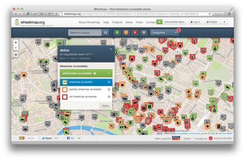
WheelMap.org provides a great interface into wheelchair accessibility data, presenting a traffic-light colour coding of accessibility, and inviting you to help categorise more map features in this way.
Researchers at the University of Heidelberg have produced a prototype wheelchair routing service. This German language only service is available at rollstuhlrouting.de. The routing for wheelchairs takes into consideration maximum slope angle, the type of surface (e.g. cobbles vs asphalt) and the height of kerbs; all this information can be mapped and added to OpenStreetMap.
In France mappers conducted an extensive detailed mapping of accessibility features for railway stations, with funding from the french national railway company SNCF as part of their initiative to support open data. A talk by Christian Quest at our annual State of the Map (SOTM) conference, gives more details.
Also at the SOTM conference we had a talk about Haptomai, one of several experiments looking at supplying maps to blind people. Check out our OSM for the blind wiki page for links to other projects, and details of the kind of map contributions which can help.
Many of these projects are in the early stages of development, and welcoming new contributions to develop the ideas further. OpenStreetMap can offer a wealth of detailed data feeding into these innovations, but only in the neighbourhoods where this data has been added. So on International Day of Persons with Disabilities, there’s lots of interesting ways to help with OpenStreetMap!
 Have you received an e-mail like this?