Category Archives: Uncategorized

Upcoming Maintenance

On Saturday 5th of July 2014 between 09:00 and 19:00 (GMT / UTC) we are moving our servers hosted by University College London to another data center.

The following services will be affected:

  • Search (nominatim.openstreetmap.org) will be unavailable. *
  • Slower map updates / Reduced tile rendering capacity. (Yevaud outage)
  • OSM Foundation websites and blog.openstreetmap.org will be unavailable.
  • Taginfo (taginfo.openstreetmap.org) will be unavailable.
  • Development Server (errol) will be unavailable.
  • Some imagery services will be unavailable. (GPX Render, OS
    Streetview, OOC, AGRI, CD:NGI aerial)

Other OpenStreetMap provided services should not be affected – all of the following are expected to function normally:

  • www.openstreetmap.org web site will allow edits as per normal (iD or
    Potlatch).
  • API will allow map editing (using iD, JOSM, Merkaartor etc.)
  • Forum
  • trac (bug-tracker)
  • help.openstreetmap.org
  • tile serving (“View The Map” & “Export”)
  • Wiki
  • mailing lists
  • subversion and git (source code repositories)
  • donate.openstreetmap.org

Technical: We are moving all the servers listed here to a new UCL data center. The current building is being closed soon for refurbishment. The new data center has better server racks, power feeds, cooling and faster networking.

* Searches through the website will still work – we will redirect
them to another nominatim instance temporarily.

Sincerely
Grant Slater
On behalf of the OpenStreetMap sysadmin team.

OpenStreetMap wins Document Freedom Day award

It’s Document Freedom Day, and we’re delighted to announce that the Free Software Foundation Europe (FSFE) has given OpenStreetMap an award recognising the project’s work on Open Standards and Emerging Standards.

Members of OpenStreetMap produce the world’s most up-to-date, accurate, and yes, open map of the world for anyone to use for any purpose. It’s used by outdoor enthusiasts, relief efforts, mobile device users, governments, web-based mapping applications and commercial organisations, showing just how useful Open Data can be.

Although the award went to the entire project (that’s You), the FSFE didn’t have room for all 1 million+ of us to turn up, so members of Mappa Mercia, the West Midlands, UK group of OpenStreetMappers met the FSFE representatives in Birmingham on Saturday 22nd March. Brian Prangle received the award, saying “It’s always great to have your work recognised, so thank you, on behalf of all the hundreds of thousands of contributors to OpenStreetMap, to FSFE for their award. We’re thrilled that you see OpenStreetMap as making such an effort towards open standards and it’s especially pleasing that you position us as an ’emerging standard'”.

Anna Morris from the Document Freedom Day campaign explained how useful the meeting was. “This was a wonderful opportunity to learn about the achievements and problems faced by a sister movement,” said Morris. “We found that we have many common goals and ample opportunity to share skills and resources.”

OpenStreetMap tags and taginfo

OpenStreetMap data includes “tags”, name=value pairs which provide a free-form folksonomy approach to classifying features. To get started mapping you don’t need to know about these. With a our easy to use “edit” interface, you can simply select from a range of feature types. For example if you select “post box”, then a node will be created with the “amenity=post_box” tag set on it.Selecting Post Box in the id ditor

But as you learn to contribute data, and certainly if you try to use OpenStreetMap data, you’ll most likely need to understand tags. To help you do this, there are a number of resources available.

You can search the OpenStreetMap wiki for tag documentation such as the Tag:amenity=post_box page. This documentation is created by the community, but rather than regarding this as the final word, understand that these wiki pages form part of a process to reach agreement on tags. You and everyone else in the community can help edit those pages to ensure the documentation is more exhaustive and more accurately reflecting the tags used by the mapping community.

But for a more direct view how tags are used by the mapping community, we have taginfo. This system counts up the ocurrances of tags in the OpenStreetMap database, and presents these statistics to give us a feel for which tags are most popular, and how many of these features we have mapped. For example, just now we see the amenity=post_box tag appears 153581 times in our database!

taginfo post box screenshot

taginfo also mines the wiki for information, finds icons used in JOSM, provides links to Overpass Turbo, XAPI, and JOSM launcher, and generally brings information about tags together to connect different sources and users.

This system was developed by Jochen Topf several years ago, but building on similar ideas such as TagWatch and TagStat which came before it. These days taginfo is a crucial tool for understanding tags, and yesterday it was rehosted on OpenStreetMap Foundation servers with various changes described by Jochen on his blog

Commercial OSM Users: Show your Support – Join the OSMF!

Since the Foundation’s last Annual General Meeting in September 2013, the Foundation has been open to corporate members. Corporate members have the same rights as normal members with the exception that they don’t have a vote at Annual General Meetings. We’re planning to create a package of benefits for corporate members (such as being prominently listed on the OSM web page). The details still need hammering out, but in any case, the main reason why anyone becomes a member of the OSMF is that they want to support the project, not for what they get in return.

You can now be among the first who publicly show their support for the OpenStreetMap project by signing up as a corporate OSMF member. The membership fee is £1,000 per year (at current rates, that’s €1,200 and US$1,650). Your membership fees will help to keep OpenStreetMap’s servers running and ensure the continued success of the project.

Read More / Join Now

…and if you want, leave a comment here to tell us that you’ve joined.

20 million edits

In January 2014, OpenStreetMap saw its 20 millionth edit.osm-20million-edit

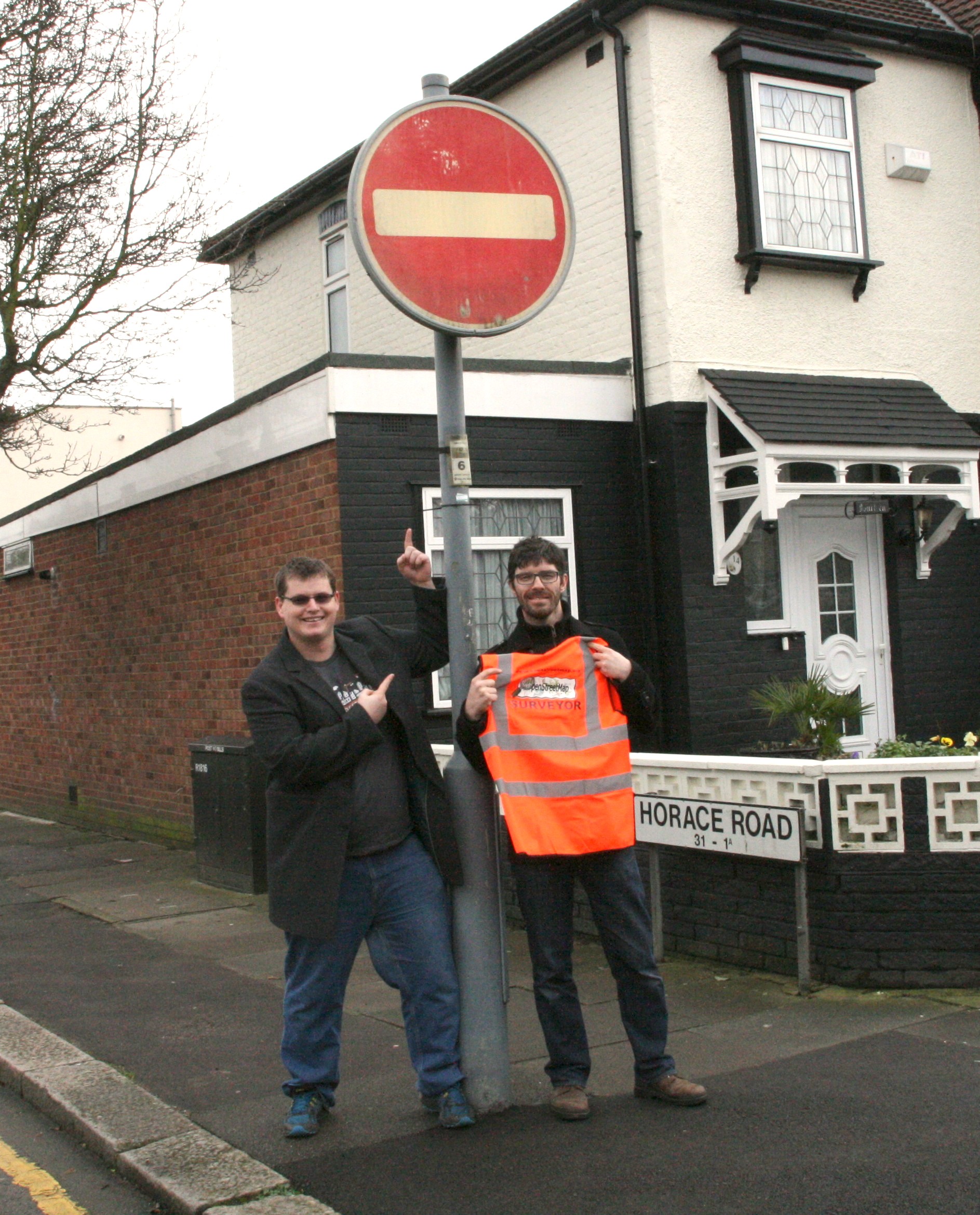
User:cosmicpop registered to edit OpenStreetMap just recently, and made a little fix to the map of his local neighbourhood. These things happen thousands of times every day, and with enough people mapping in their local area, we’re building a free and open map of the world!

But this time was special. This was the 20 millionth edit saved to OpenStreetMap. To celebrate, we decided to get in touch, and present this contributor with a prize. Here is cosmicpop with his new OpenStreetMap hi-vis jacket!

“Wow, I’m not the superstitious type, but this is the first time I’ve ever edited on OpenStreetMap, while in my other browser tabs I was looking for a hi-vis jacket to wear while cycling which I have recently taken up. Maybe I should do the lottery this weekend.” – Cosmicpop

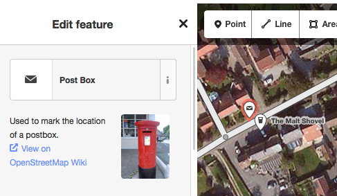
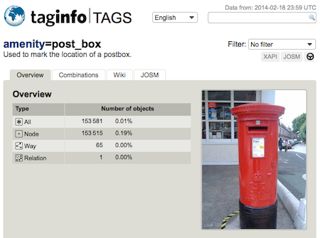
Cosmicpop tells us he had been thinking about contributing to OpenStreetMap for a while now, and decided it was time to fix a one-way restriction which was missing from all maps. Friends visiting him were often surprised by the one-way not being marked on their satnavs. Well now it’s correct on OpenStreetMap – a great local improvement by a new user for our 20 millionth “changeset”!

Changesets? Edits?

When you’re editing OpenStreetMap you can add new map elements or modify existing ones. Your changes – be it one or a hundred – are sent to OpenStreetMap when you click “save”. Simple!

When you do this, you write a little message describing your change, and this is recorded, together with your edits, as a “changeset”. We just hit 20 million of these bundles of changes, some big, some small.

You can view your own changesets from your OpenStreetMap profile page, or view the latest changesets from all users. For a more spectacular global view of changesets as they happen, check out live OSM edits, and “show me the way“.

More stats

Of course changesets are not the only stats we track. OpenStreetMap also has…

2.17+ billion Nodes in database
214+ million Ways in database
3.78+ billion GPS points in database
1.5+ million registered users
Check out the stats page for more.

Buenos Aires hosts SotM14

buenosaires_benontherun.com_ccbyncsaAfter being in Europe, North America and Asia, it is time to explore yet another continent. We’re happy to announce that the 8th international State of the Map 2014 conference will be held in Buenos Aires, Argentina (map) on November 7th – 9th.

OSM is a truly global project with people all over the globe. Having SotM14 in Argentina is a great way to show the world what’s going on in South America regarding OSM and it can help strengthen the local OSM communities there.

If you haven’t made holiday plans for this year yet, why not consider Argentina in the spring? (yes, it will be spring there)

In case you live in Europe or North America and you feel Argentina is too far away? You’re still invited to join SotM-EU (Karlsruhe, June 13 – 15) or SotM-US (Washington DC, April 12 and 13).

More details about SotM14 will follow later this month. Stay tuned.

[UPDATE: Lots more details can be found at stateofthemap.org]

(image by benontherun.com cc-by-nc-sa 2.0)

Goodbye 2013, Hello 2014

simon-poole

Simon Poole
OpenStreetMap Foundation Chairman

It’s customary at the end of the year and at the start of a new to reflect on what has been achieved and highlight noteworthy events in the past year. For OpenStreetMap 2013 would seem to me to be the year in which using our data is no longer extraordinary, but normal.

Over the course of the year we have seen devices from Bosch, Garmin and others being announced or delivered ex factory with OSM based maps, and we’ve seen a number of media houses switch to using OSM for their online publications. None of these seemed to be perceived as earth shattering, just matter of fact. The downside is that we have to actively remind ourselves that we, a small free and open project, are achieving astounding inroads in to an area of activity otherwise open only to governments and multi-billion dollar corporations.

For old hands 2013 is more likely to be noteworthy for two quite visible changes. One was the introduction of the new default editor iD. I would like to take the opportunity and specially thank the authors of previous default Potlatch 1 and 2  that are so closely coupled to the success of OpenStreetMap and which have served us, and continue to do so, well over many years.

The other change  naturally was the deployment of the web site redesign replacing the sidebar and tab layout with the current design. If archive.org is to be believed the previous layout had been with us since December 2005  and it was not a surprise that there was some turmoil and emotions accompanying the change.

At the end of the year our special thanks should also go to the volunteers that keep our infrastructure running and further to all contributors big and small that make OpenStreetMap what it is.

From the perspective of the OpenStreetMap Foundation among our goals for 2014 are  formalizing the relationship with our national and thematic organisations and to stabilizing our funding model going forward.

The project as a whole continues to show healthy growth both in coverage, participants, quality and usage. If I was personally asked what we need to consciously add more of, instead of just doing what we always do, I would point to address collection. While we added up to an incredible 1 million addresses per month in 2013 we really need to increase this a bit and while, naturally, some of this will come from imports, just walking around a block and jotting down the house numbers every time we are somewhere new could greatly increase the rate at which we approach the goal of including a free address dataset in the OSM data.

On this note, I wish everybody a happy new year and have a fun 2014 mapping.

Seasons Greetings

Seasons greetings to all OpenStreetMap contributors!

OpenStreetMappy Xmas Biscuits

…and I hope you all had an OpenStreetMappy Christmas.

I know I did. On Christmas day I managed to use OpenStreetMap for our family Christmas walk, and contributed a bit more data (More on that here)

What other Christmassy map happenings have happened?

How was your OpenStreetMappy Christmas?

Disability Mapping with OpenStreetMap

Today is International Day of Persons with Disabilities.

We’re gathering map data related to disabilities within OpenStreetMap, and because the map is openly editable, you can help!

Edit the map of your neighbourhood to add details on wheelchair accessibility, and the presence of things like tactile paving for blind people. Details of the world which we may not imagine to be important, can be very useful things when presented on a map to help people with a variety of disabilities. We have OpenStreetMap “tags” for them all, from gluten-free food outlets, to more simple things like steps and toilets. It’s a lot of detail, but with thousands of people all mapping their own neighbourhoods we can map the world for disabled people.

A number of projects are delivering very interesting custom map applications, of a kind which would only be possible with free open access to raw geo-data:

WheelMap.org provides a great interface into wheelchair accessibility data, presenting a traffic-light colour coding of accessibility, and inviting you to help categorise more map features in this way.

wheelmap-screenshot-en

Researchers at the University of Heidelberg have produced a prototype wheelchair routing service. This German language only service is available at rollstuhlrouting.de. The routing for wheelchairs takes into consideration maximum slope angle, the type of surface (e.g. cobbles vs asphalt) and the height of kerbs; all this information can be mapped and added to OpenStreetMap.

In France mappers conducted an extensive detailed mapping of accessibility features for railway stations, with funding from the french national railway company SNCF as part of their initiative to support open data. A talk by Christian Quest at our annual State of the Map (SOTM) conference, gives more details.

Also at the SOTM conference we had a talk about Haptomai, one of several experiments looking at supplying maps to blind people. Check out our OSM for the blind wiki page for links to other projects, and details of the kind of map contributions which can help.

Many of these projects are in the early stages of development, and welcoming new contributions to develop the ideas further. OpenStreetMap can offer a wealth of detailed data feeding into these innovations, but only in the neighbourhoods where this data has been added. So on International Day of Persons with Disabilities, there’s lots of interesting ways to help with OpenStreetMap!

Upgrading from Google v2 API? Free yourself and upgrade to OpenStreetMap

google-v2-javascript-no-longerHave you received an e-mail like this?

“We cannot guarantee that your maps will continue to function. We highly recommend that you migrate to Google Maps v3 before November 19.”

Yes, Google Maps are shutting down their old JavaScript Map API (v2). They recommend that you spend a lot of time rewriting your code to switch to the newer v3 API.

But why not spend that time switching to something better?

OpenStreetMap is the map made by experts – the locals who know their area intimately. It has footpaths and bike paths, alleyways and waterways, green spaces and public places, along with the roads and railways you expect. It’s updated every minute of every day, not just next time Google sends out a StreetView car. No wonder big names like Foursquare, Github and Mapquest have already made the switch to OSM.

Switching from Google Maps to OpenStreetMap is easier than you think. If you’ve struggled with the old Google Maps APIs, you’ll find our equivalent, Leaflet, a breath of fresh air. Its smooth presentation will give a real lift to your site’s appearance, and on mobile it’s as fluid as a native app.

And if you want to go further, OpenStreetMap lets you build your own, beautiful custom maps from our data. You’re not limited to the same Google styling that everyone else uses. Because it’s all open source, you don’t even have to pay us anything for ‘premium’ services.

So how do you do it? The OpenStreetMap community runs the switch2osm.org website which offers several recommendations for switching to using OpenStreetMap. Check out the ‘Basics’ and ‘Using Tiles’ sections to find how to switch your JavaScript to OSM. If you want to build your own custom maps, you’ll find full details there too.

Because ultimately, OpenStreetMap is much more than a Google Maps API replacement. We offer something rather different: free and open access to raw map data. This empowers developers to unleash a wave of innovation and creativity which goes beyond embedding maps on a website. Best of all, when people use OpenStreetMap on their websites, more people see the map; more people join in with mapping efforts; and the community-created map gets even more detailed. By using OpenStreetMap you are supporting it, and helping us with our not-for-profit mission to create the best free and open map of the world.

switch2osm.org