Author Archives: OpenStreetMap

About OpenStreetMap

Posts written "by OpenStreetMap" were written collaboratively by the Communication Working Group and/or other OpenStreetMap Foundation folks.

The State of the Map scholar experience

We were delighted to welcome 15 scholars to Japan for State of the Map 2017. Scholars help make State of the Map one of those unique moments in our community when we come together and share our mapping experiences in person, from literally every corner of the globe.

With the generous support of our sponsors and the tireless effort of the organizing team, for the first time at a State of the Map we achieved 100% success in visas and scholar attendance. Visas can be long and bureaucratic ordeals! Extra special thanks for Dorothea for going above and beyond in supporting this work — including calling up Japanese consulates around the world!

We asked the scholars to share a few words on the experience. We love reading about the experience and what it’s inspired for the future — required reading if you love OpenStreetMap! Here’s a few excerpts…

Anisa Kuci – full post
“After answering the questions that were kindly asked by the audience, I was ready to enjoy so many great talks, workshops and lightning talks I spotted on the agenda for the next three days, and a very productive meet-up that happened the third day of the conference, where everyone shared thoughts about how local chapters and OSM Foundation can help each-other grow bigger, and we had the opportunity to share the wish of the Albanian speaking community to become a chapter.”

Georgia Marina Andreou – full post
“The scholarship gave me the chance not only to raise awareness on the impact of natural processes on cultural heritage, but also to understand through an array of examples the truly empowering capacity of mapping. As such, I left the conference with a long list of ideas for future mapping.”

Jaisen Nedumpala – full post
കോണ്‍ഫറന്‍സില്‍ പങ്കെടുക്കുന്നതിലുപരി, ഒരു വികസിത രാജ്യത്തെ സ്ഥിതിഗതികള്‍ നേരിട്ടു കണ്ടു മനസ്സിലാക്കണമെന്ന ആഗ്രഹം കൂടിയുണ്ടായിരുന്നു മനസ്സില്‍.

Marco Minghini – full post
“Another indelible memory from SotM 2017 is the official announcement I gave during a Plenary Session about the next State of the Map conference, that my university (Politecnico di Milano) will host on July 28-30, 2018 in Milan, Italy! It was amazing to make this announcement and get that long, long applause :)”

Samaila Alio Mainassara – full post
“Cette participation m’a permis de découvrir l’écosystème OSM à travers les échanges et le partage d’expériences avec les différents participants.”

Selene Yang Rappaccioli – full post
“El espacio de discusión que se realizó durante ésta última edición del SOTM Internacional, contribuyó a crear diálogos, conocer perspectivas y esclarecer dudas sobre la necesidad de construir, no sólo el mapa más completo, sino también la comunidad más completa, donde se abarquen las diferencias, multiplicidades, diversidad de miradas y diferentes relatos y experiencias.”

Sidorela Uku – full post
“I saw that maps were more than a visualisation of our world, there is humanity, they can be as important as saving lives. This conference really affected me emocionally and also inspired me a lot. Now I want to do even more, have many things in my mind, need to set up a plan and continue contributing.”

Suthakaran Sundaralingam – full post
“I also plan to become a member of the OpenStreetMap Foundation, and form an OpenstreetMap foundation in Sri Lanka.”

Tommy Godphery Davian Charles – full post
“getting acquainted with each other was a walk over, this was possible because we all spoke a common language which is ‘Maps and Development’.”


State of the Map Working Group

Registration is now open for State of the Map 2017

Tickets for State of the Map 2017 are now on sale! Come register for this international gathering of the OpenStreetMap community. Move fast in order to guarantee yourself the “Early Bird” discounted rate!

Get your ticket here

State of the Map offers value for anyone excited about open location data. Our main conference days will feature nearly 50 talks, open spaces for gatherings, and exhibition areas where individuals and organizations can meet. Hundreds of OpenStreetMap community members are expected to attend and we want you there!
The early bird catches the worm. Or “早起きの鳥は虫を捕らえる.” The world of OpenStreetMap belong to those who get (tickets) early.

SotM 2018 Call for Venues

The State of the Map working group is delighted to announce that the call for venues for the year 2018 is now open!

State of the Map 2018 – Call for venues

Why so early?

Following on from previous years we are opening the call for venues early. This gives you the greatest flexibility over dates you can pick in 2018. It also makes it easier for others who may be wanting to run OpenStreetMap events – we can assist with calendar planning to help avoid any problematic clashes.

How’s SotM 2017 shaping up?

Planning for State of the Map 2017 in Aizuwakamatsu, Japan is coming along nicely. We are currently reviewing the applications for our scholarship program, whilst the call for proposals closes this Sunday. Keep up to date with all the latest news about event tickets, hotel deals and the final program by signing up to our newsletter.

Contact us

The State of the Map working group is here to help you. This year we have provided a template to help you when it comes to recording details about potential venues and catering services. We encourage you to contact us on team@stateofthemap.org as early as possible so that we can provide guidance if required.

Planned downtime Sun 12th 11:00

In case you missed the mailing lists announcement from the Operations Working Group, there will be a one hour period of downtime next Sunday (week today) :

We are planning to upgrade the software which runs the main OpenStreetMap database. Unfortunately, we cannot do this without a small amount of downtime. We would like to schedule this at a time which minimises the impact it will have, and plan to conduct the upgrade between 11:00 and 12:00 UTC on the morning of Sunday 12th March.

We expect that the database upgrade will not take the full hour, and we will endeavour to keep the site online for as much of that period as possible, and have it back to normal status as quickly as possible. However, there’s always the chance for things to go wrong, so please plan for the site to be down for the whole period.

The website and editing API will be affected, but other OSM services including the tile server, Nominatim, wiki, help and taginfo should continue to work as normal.

We will keep you updated through the Platform Status wiki page and OSM_Tech twitter account

If you experience any problems with the API after the end of the upgrade, please get in touch with us on the #osm IRC channel, or by email.

Apologies for any disruption this may cause and many thanks in advance for your patience,

Operations Working Group

Launching OpenStreetMap driverless cars

As an organisation we’ve always prided ourselves in keeping up with commercial mapping companies’ innovations. That’s why OpenStreetMap is today announcing the launch of Coaster – the first product from Phaethon, the OpenStreetMap driverless car project.

OSMF Coaster

OSMF Coaster (Image cc-by-sa OSVehicle on flickr)

Following in the footsteps of other map-providers-cum-car-manufacturers we recognise that cars without drivers are now within the realms of possibility, and we can develop them as a technology project, iteratively, starting from prototypes. Making use of our accurate road maps, this is a natural area for OpenStreetMap to move into. We expect to see the coaster driverless cars on real roads within the next two years.

The OSMF Coaster

We’re doing this the open source way, and the OpenStreetMap Foundation are working with the folks at OSVehicle who have developed the engine and chassis as an open licensed design while a team in Italy designed the stylish “NIKA” outer shell of this vehicle.

You’ll notice these prototypes feature a steering wheel. This will remain as a safety feature during a testing and data-correction phase, but naturally we’ll be removing the steering wheel when the coaster goes into mass production, as these cars will connect to OpenStreetMap’s data and will no longer need a driver!

How it works

OpenStreetMap is truly a collaborative endeavour, and we intend to build on that tradition by making driving with the OSM car a collaborative experience.

We have always believed that “the perfect is the enemy of the good”. We recognise that there are occasional errors in any map dataset, as Google has repeatedly demonstrated.

Our self-driving car breaks new ground by automatically correcting OpenStreetMap data based on your driving behaviour. Such “passive contributions” have the potential to greatly expand OSM’s contributor base, given that 97% of existing contributors are cyclists.

For example:

osm-driverless-car-data-correction

The car’s navigation unit will consume OSM “minutely diffs”. Not only does this ensure that drivers can enjoy up-to-the-minute map data, being able to navigate along new roads instantly without waiting for a monthly update cycle, it provides a virtuous feedback loop for OSM routing. For example, if an OSM contributor inadvertently deletes all the exit routes from a roundabout, such an error will be instantly noticed by any passengers in self-driving cars currently transiting that roundabout.

Ready to go driverless?

You’re probably keen to hop inside an OSMF Coaster. If so, leave a comment below saying “I want one!” and we’ll get in touch about prices and delivery of an early prototype. We will be running off a limited edition batch towards the end of 2016.

In the meantime there are a couple of ways you can help:

Firstly, our tests so far have revealed a few problems related to road lanes. Please review the lanes tagging information and ensure that lanes data is present and correct at the larger roads/junctions in your city. We’ll be refining this kind of data automatically following the process described above, but for safety reasons we recommend you add as much lanes data as you can to OpenStreetMap at this stage.

We expect our cars to be road-certified in various jurisdictions without too much trouble, but if we encounter any obstacles we will be calling upon local OpenStreetMap communities to lobby their governments to speed this process. Keep a look out for campaigns in your area.

Finally please note that the estimated timeframes may slip beyond 2016 for the delivery of prototypes. Also note that the photo at the top is for illustration only, and those ordering an early prototype will be receiving a coaster made with prototyping materials. Thank you for your understanding. We hope the wait will not be too long.

…and happy driving (or not driving we should say!)

State Of The Map 2017 – call for venues

The state of the map working group are delighted to announce that the call for venues for 2017 is now open!

http://wiki.openstreetmap.org/wiki/State_Of_The_Map_2017/Call_for_venues

Sotm_logo_2017

Why so early?

Following on from last year we are opening the call for venues early. This gives you the greatest flexibility over dates you can pick in 2017. It also makes it easier for others who may be wanting to run OpenStreetMap events – we can assist with calendar planning to help avoid any problematic clashes.

How’s SotM 2016 shaping up?

Planning for State of the Map 2016 in Brussels is coming along nicely. We’ve got a date, a great venue and have also secured a hotel deal for the delegates. Keep up to date with all the latest news about event tickets, scholarships and the “call for presentations” by signing up to our newsletter.

What’s the vision for 2017?

State of the Map has traditionally been an annual conference of a few hundred delegates. During 2015 we looked at the key aims of the OSM get together and developed a vision for 2017. The vision is sufficiently broad to accept all styles of bid – we’re open to new ideas if a compelling case is put forward.

Contact us

The State of the Map working group is here to help you. This year we have provided a template to help you when it comes to recording details about potential venues and catering services. We encourage you to contact us on info@stateofthemap.org as early as possible so that we can provide guidance if required.

— State of the Map, working group

A look back at Google Summer Of Code 2015

Google Summer of Code is a program that matches student developers with open source projects. Students are paired with experienced mentors and spend a few months full time on improving open source software. Ideally, students get a decent stipend (paid for by Google) and good experience, while the projects get significant code contributions and exposure.

OpenStreetMap first took part in 2008, and has become a regular participant in Google Summer of Code since. We offer a big playground for students: Thanks to the efforts of hundreds of volunteer developers, there have always been a lot of active open source projects in our software ecosystem, and OSM would not be possible without them. With so many interesting tasks to choose from, we decided to once again participate in last year’s Google Summer of Code.

When we announced our participation in the program for 2015, we received a large number of very good applications from students around the world. Eventually, we were able to accept 8 of them, filling the number of slots allotted to us by Google. Seven students made it to the end, which is a good success rate after all. Five of these projects have already been merged upstream and are in use as of writing this. This article offers a more detailed look at all seven successful GSoC 2015 projects.

Carto-CSS

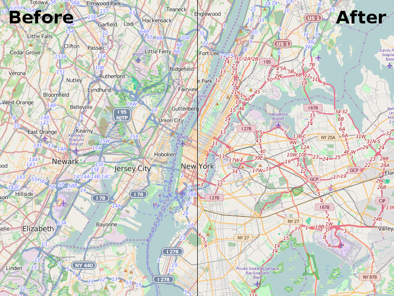
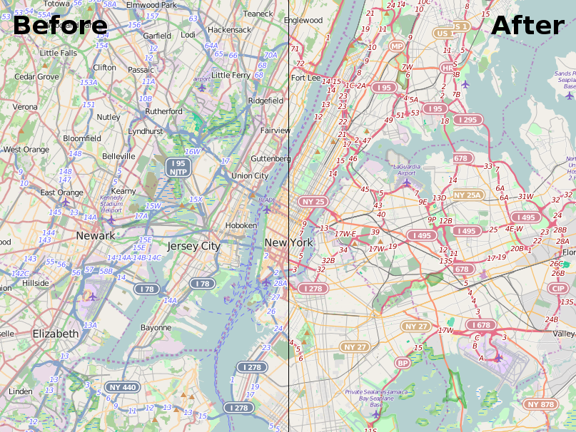
First of all, probably the most prominent project has been the redesigning and reimplementation of road presentation in our default OSM map style (openstreetmap-carto) which appears on www.openstreetmap.org. Besides the analysis, designing a road style from scratch and doing many experiments with the new style, the student also needed to communicate his ideas with the wider community – after all, this project would mean a major change of the main style, which usually progressed in much smaller increments. As OSM started in Great Britain, the style has been inspired by common British map styles in the past. Some call it the “rainbow color style” as every road type gets its own color, using as many colors as possible. This lead to problems such as green streets in the woods or blue streets besides rivers. The new style tries to be much cleaner in that sense. The different opinions on the style meant that it took some more weeks after the end of Google Summer of Code until the code got merged. But finally, the new style was activated (announced here in October) and the work has been widely regarded as a success. Here’s how the road colours changed on a map of New York, but have a look for yourself at your town on www.openstreetmap.org.

before-after road styles

 JOSM

Overall, we had three projects to work on JOSM this year. JOSM is one of the applications to edit OpenStreetMap data and it’s been one of the first editors out there – in fact, most of the data in the OSM database was contributed using JOSM! It has matured into an expert editor, with a huge set of features and an additional large set of plugins to customize it. But it not only allows you to edit the data, it has a bunch of options to aid the editor in working with the data. Ranging from simple presets to make editing easier, displaying images made while recording an area to selecting background imagery to enhance the position accuracy. There’s much more and it’s a really great tool to use. You should have a look and try it for yourself.

OpenGL Plugin

The first new plugin for JOSM was a quite interesting and unusual project. It’s been the only project that has not been suggested by the mentors but by the student himself. One has to know that JOSM is written in Java and therefore utilizes the Java2D API for its main drawing pane. In advance, the student did some preliminary performance tests to show his idea is worthwhile: His plan was to replace the main canvas with a new implementation based on modern OpenGL, using vertex buffer objects for high drawing speed and at the same time supporting all features of the current implementation. Besides his groundwork, he had to do several extensions to the JOSM core and extend the plugin API to make his idea work at all. Additionally he encountered other problems, e.g. how to make the code self contained in one jar file, even though the OpenGL libraries he was going to use had some native libs included. Anyway, he did a great job and besides the problems noted, he produced a really nice plugin which does all of the drawings in OpenGL. This pays out especially for large scenes or densely mapped cities, but it may noticeably boost performance even for smaller data sets. But in the end, it also depends on your graphics card in use. Once the plugin is installed, there’s a switch in the main menu bar to activate and deactivate the new drawing pane, so you can have a look yourself.

Mapillary Plugin

The second JOSM related project was a plugin to make use of Mapillary. Mapillary is a site for sharing geotagged photos that aims to represent the whole world with photos. As many of you might know, all photographs are released under the CC-BY-SA license and it is explicitly allowed to make use of them to enhance OpenStreetMap. Furthermore, Mapillary provides an API to query for images, load and store images and associated meta data. As a useful mapping data source, we naturally would like to see support for it in JOSM. Once activated, the map edit view of JOSM gets enhanced with a visual feedback of photos taken nearby. That means you’re now easily able to verify what you enter in the map. For example, you may edit a highway and have a look at photos taken along the way to see when and where speed limits change. You can have a look to remind yourself if there’s a zebra crossing, or verify if a bus stop has a waste basket or not. There are tons of use-cases, you just need to activate the plugin and hope that someone took a photo for the case you need.

JOSM_mapillary_plugin

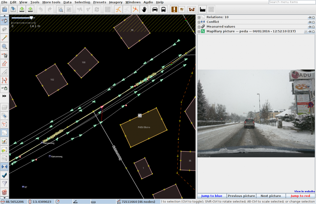
Image Filters Plugin

The third plugin is intended to filter images in a variety of ways. As noted above, JOSM features the facility to add background images to the map. For example you’re allowed to put Bing imagery as a background layer and trace buildings for OSM. However, there are sets of images or regions with poor quality. They may be too dark, too light, or distorted in other ways. The plugin that was written in this project provides an infrastructure to manipulate images in a variety of ways. With only two clicks you can now do a gamma correction of the current imagery.

OSM2World Shader

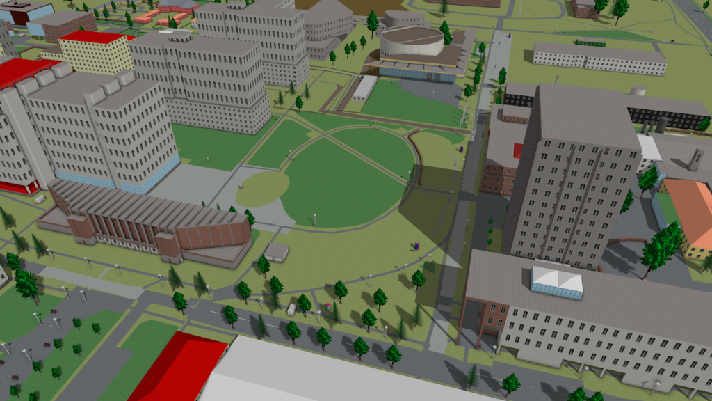
This project was aimed at improving the rendering capabilities of OSM2World. OSM2World is a tool to convert OSM data to 3D models of different formats and therefore also features a viewer application for directly displaying the 3D models, and walk around in the scene. While the code already used vertex buffer objects, it was still using the fixed function pipeline of OpenGL. So the project’s goal was to move to a modern version of OpenGL, using vertex and pixel shaders. Besides that, the goal was to add support for some fancy features, time permitting. The student, new to OpenGL, did some research in advance to Google Summer of Code, so that he was able to start refactoring the code very quickly. Finally there is now a shiny new and modern OpenGL backend based on shaders only. Besides implementing lighting with a phong shader and basic texturing, there have been additional noteworthy extensions: For the first time, there’s support for bumpmaps, there are shadow maps as well as shadow volumes, there’s now ambient occlusion for even more realism of the scene and finally MSAA to remove jagged edges. The student even continued to work at his code and it was finally merged upstream. Besides the screenshots presented here, there’s also a web map for parts of Europe at maps.osm2world.org.

OSM2World Shader KIT

Moderation Queue

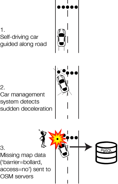
OpenStreetMap is a collaborative project with a fair amount of friendly cooperation between different users, but there are also times when problems arise, be it vandalism, spam or interpersonal conflicts. The project has some means to deal with these problems, but it’s not always good enough. The website itself features a full message system, allowing users to write other users private messages. If a message is related to a change rather than a person, we also have a feature called changeset discussions (the result of a former Google Summer of Code project, by the way). But we don’t have a proper way to signal the need for either moderators or administrators to take action on problems. This project offers a solution by introducing two main features to our website: First of, there’s a “moderation queue” that collects the different issues. Moderators or administrators can pick an issue, work on it, comment on it and set the issue to solved once it’s finished – similar to a ticket system, but specialized to OpenStreetMap’s needs. Second, the moderation queue has to be filled. So the project implemented the possibility to report problematic notes, changesets or users, allowing users to help fight spam, offensive messages and other issues. Unfortunately, this work has not been merged into mainline yet, so it’s not publicly available at the moment.

LearnOverpass

The primary goal of the Learning platform for Overpass API is to make it easier for newcomers to learn and use the Overpass API. For those not familiar with Overpass API, it is a great service that allows you to query OSM data in a very flexible and fast way without writing code. It is a dedicated query language that can be used to not only ask for nodes, ways or relations with special tags but also allows you to query for metadata such as usernames or last edit dates. You can also restrict results with further constraints. Martin Raifer, the mentor for this project is well known for his work on Overpass-Turbo, a site that offers a rich query editor, together with wizards and other useful tools, and visualizes the results of Overpass API queries, making it an invaluable tool for both developers and mappers. One hurdle for beginners, though, can be learning the query language, and not everyone is able to make sense of its documentation.

That’s why this project produced a site, a learning platform, that teaches the use of the Overpass API. Similar to Overpass-Turbo, the learning platform helps you with direct visual feedback, but combines it with very easy examples and good explanations to help you getting started. While the student did a good job, there’s still a bit of work to be done. It’s still planned to publish the work prominently on overpass-api.de and on the OSM-Wiki, but that needs a bit of spare time to do the extra work to finish it off. In the meantime you can see the work in progress at osmlab.github.io/learnoverpass/,

Summary

This has been a great Summer of Code for OpenStreetMap, as we had interesting projects, and we had great students who worked hard and it helped to bring many projects forward. It remains to be see if these students will become a part of our developer community in the long term and continue to contribute code or help to map new data, but we’re confident that at least some of them will stick with OpenStreetMap. In that sense we’d also like to thank the Google open source team for this great initiative.

By the way: We’re currently in the process of applying for 2016’s event. If you are a student who would like to participate, stay tuned for updates and have a regular look at our wiki page on GSoC 2006 and the Google GSoC homepage.

Blog post by Peter Barth and Tobias Knerr

Welcome OpenStreetMap Italia

The OpenStreetMap Foundation is excited to welcome its second official Local Chapter organization: OpenStreetMap Italia.

OpenStreetMap Italia is a subgroup of WikiMedia Italia – associazione per la diffusione della conoscenza libera. Long-standing OpenStreetMap leader Simone Cortesi led the process of working with the OpenStreetMap Foundation and Wikimedia Italia to reach this milestone. Simone is the current President of the Local Chapter. He previously held a seat on the Board of Directors of the OpenStreetMap Foundation. He is also a long time contributor to the OSM project as a mapper, organizer and developer.

Simone Cortesi of OpenStreetMap Italia (left) and Martijn van Exel OSMF board (right), signing the local chapter agreement

Simone Cortesi of OpenStreetMap Italia (left) and Martijn van Exel from the OpenStreetMap Foundation board (right), signing the local chapter agreement

The Italian community has been one of the more active local communities since the beginning of OpenStreetMap. Around 150 people contribute to OpenStreetMap in Italy every day. A bi-weekly newsletter dedicated to local Wikimedia and OpenStreetMap topics reaches an audience of around 25,000. The OpenStreetMap Italia Local Chapter has 450 members that represent the diversity in the Italian OSM community.

OpenStreetMap Italia, combined with WikiMedia Italia, has a staff of 7 people, with one full time project manager working on OpenStreetMap and one half-time working on training and outreach. The Chapter’s new official status will allow WikiMedia Italia to fully support OpenStreetMap initiatives in Italy and enable stronger collaborations, especially in the government domain.

Field Report of a Board Freshman

New foundation board member Peter Barth

One month has passed since the elections, so I decided to write down a little blog post about my impressions as a new board member. Even though I had listened into a board meeting and participated in an OSMF working group before, there were still many things to learn and new tools and processes to get acquainted with. This post is not super specific, but I still hope this will be an interesting read for others who are curious how the OpenStreetMap Foundation board works.

The infrastructure

Once the election results came in, everything happened quite quickly and we got a bunch of new accounts for various services. As you might remember, the election results were final on December 12, 2015 around 19:00 (CET). Less than 6 hours later, I was added to the internal board mailing list (the board@ address). Well, perhaps I was added earlier, but at 00:27 my first board mail arrived. This list is the main communication channel for the board and almost anything is discussed there. The address can be used by anyone, by the way, so if you have any matter to discuss you’re free to write to this address to reach the whole board – though reading is limited to the board directors. Just to give you an impression about the traffic, I got 266 mails until today on that list. Only 25 hours after my election I also got a personal @osmfoundation.org mail address which should be used whenever I want to speak as an official board member. Mails sent to these addresses are handled and, depending on the configuration, archived by Google.

The same day, we got accounts for the public OSM Foundation wiki and for the private wiki of the board. The latter is to be used for internal stuff, e.g. it now contains a primer page with all the stuff new members need to know. I haven’t changed much myself yet, but I read a lot and even though the wiki is not that large (about 30 pages), there is much information to process.

In addition the above, there’s a service called Loomio, which is used for deciding on board resolutions outside of meetings, so called circular resolutions. That seemed kind of superfluous to me, but it appears to have been introduced some time ago to make it easier to manage resolutions as there was a lack of clarity about status and conclusion and as resolutions via emails had a low number of participants. (When the first circular resolution of this term passed, Paul almost incredulously noted that this was the first time he ever saw all board members vote.). Anyway, the tool itself is neatly organized, easy to use and you can choose to receive email notifications when something happens within our group.

The board does not have a ticketing system, by the way, but has great human tracker: Paul. He collects items from the mailing lists and amazingly manages all that so nothing gets lost. Other than that, everyone has their own list of open items. Not everyone was happy with this, however, so we discussed whether to try something different this term. That’s why there will be a trial period where we use the issue tracker of GitHub to keep track of open tasks, assign tasks and so on. We’ll see how that turns out.

There are some other tools in use, too, but there were no special actions needed to set them up. For example, we use Doodle to agree on a date and we use Mumble for our meetings. We have an IRC channel to talk to each other, though seeing how not everyone is used to irc, it gets used to chat rather than discuss. And finally there is CiviCRM for the members’ database, accessible via a WordPress plugin. But it took me a while to get access to that one, as I did miss the invitation mail.

Legal obligations

As the secretary needs to submit an “Appointment of a director” form to the Companies House, I had to give some personal details to Paul, including my date of birth and my private address. It’s the directors’ duty to submit this information, as the details about the directors on the board have to be made public, according to British law.

I’m also working on getting access to our bank account as I was selected as a backup for our treasurer. After trying to get hold of someone explaining me how to do that and struggling to understand the London dialect of a nice lady from customer support at Barclays, I was glad that Frederik was able to help me. Eventually, I had to get an certified copy of my ID, fill out a bunch of forms and be very cautious to put my signature within given bounds to not invalidate these forms. And now I’m waiting to see what happens. If I’m unlucky, I’m going to have to travel to Frankfurt to appear in person at Barclays.

Getting started

So with all the preparations out of the way, what has the board worked on since the elections?

During the last few weeks, we processed a few tasks related to our working groups, such as budget requests. Unfortunately, there were also legal disputes affecting the DWG that the board had to deal with. We used the opportunity to talk at length about our interactions with working groups in general, and how to support their work without interfering with it. Naturally, there were different ideas and interesting discussions, and I expect that there will be small but exciting changes to come. As much of the actual work is done by the working groups, they form an integral part of the OSMF and OSM in general. Other than that, we also dealt with some inquiries by different NGOs, and of course there were mails from newbies like me, asking silly questions.

Whenever there are topics that need to be decided on, we use votes to form a consensus. Either at one of our Mumble meetings which take place one a month, or via Loomio as a circular resolution if the topic can’t wait or is considered simple enough to not warrant any discussion at a meeting. For something to get passed a simple majority is enough, and notably there’s no quorum to be reached. In theory, it would be possible to decide on something with only one vote in favor. (No, that hasn’t happened yet.)

Conclusion

Now that I’m getting more familiar with the way things work, I’m eager to work on the challenges I outlined in my agenda, and I’m sure my colleagues are, too. As always, the board is happy about any input or contribution on osmf-talk@, by direct mail or to the OSMF in general. Even if a matter is already discussed on the board, it feels good and necessary if the members discuss topics, suggest things and demand answers, too. So please continue contributing to osmf-talk@ to make it a livelier place.

And last but not least I hope that this post has been an interesting read that can help others who consider running for the board, contributing to one of the great working groups out there, or simply joining the OSMF as a member.

Peter Barth

The map you see on OpenStreetMap.org is changing

If you head over to OpenStreetMap.org and click on the layers button on the right of the map, you are provided a selection of map layers to choose from. This is possible due to the nature of OpenStreetMap – by distributing open geographic data we enable others to produce a map from OpenStreetMap data in whatever style they require. The OSM website provides five such styles but there are many hundreds, if not thousands of other styles in use across the web.

We will shortly begin to roll out a new version of the ‘Standard’ (or default) map style replacing the current version. Although the new version is an evolution of the existing version, the changes to road colours and the display of railways will significantly help to improve the readability of the map. During this roll out you may see a patchwork of old and new map style for a few hours – please be patient whilst our servers work hard to update all corners of the map.

before-after road styles

How will the style change?

The change of the map style will primarily effect the way roads and railways are displayed. As OpenStreetMap has grown over the last 11 years we have began to collect more and more information about our surrounding environment. The standard map style has adapted to display this information, but over time this has led to the road and rail network becoming harder to identify. For example, trunk roads (currently shown in green) can be very hard to see in heavily forested areas.

In the new map style “road colours [are] tuned to ensure that roads are well visible on all landcovers”, explains Mateusz Konieczny, who has developed the new style (project details) . Mateusz has worked with the OpenStreetMap community at every step of the journey from initial research to draft implementations to gather feedback on the design. He adds that “steady progression of hue and lightness for major road types (motorway, trunk, primary, secondary, tertiary) should make more intuitive which roads are more important”.

There’s been other recent changes to the style – why highlight this one?

You’re right. For the last few years there has been a new map style released every two to three weeks. As with all things OpenStreetMap there is an army of volunteers working to fix and improve the map style. It would be great to write about all of them but that’s simply not possible. So this change, being one of the larger ones and a Google Summer of Code project, gives us a great opportunity to pause and thank all those who have contributed to the map style. Thank you style maintainers!

What next for this map style?

In the short term, it’s likely to be small incremental tweaks so as to continuously improve the map. Every big change attracts new style maintainers who bring their own ideas and experience. There may be a few minor tweaks to the paths and roads based on their ideas.

There is also an updated version of Mapnik, the underlying toolkit used to convert the written style rules in to the final map you see on the OSM website. The latest version will help to fix a lot of bugs related to non-latin scripts/languages. In the longer term there is the option to repopulate the database used by the Standard map style so that it has access to all OpenStreetMap data tags, not just a limited few.

Can I help with development of the ‘Standard’ style?

Yes. The standard map style, which is known as OpenStreetMap-Carto is available on GitHub. Andy Allan, who re-energized the development of this map style in 2012 has given a number of talks at recent OpenStreetMap conferences. Two good starting points are his talk at State of the Map US 2015 in which he gave a progress update for the project, and the detailed workshop he ran at State of the Map EU 2014.

And what about the other map styles?

Well this change only affects the ‘Standard’ (or default) layer as seen on openstreetmap.org.
There are a number of alternative map styles available or you could make your own. Perhaps you want to produce your own personal map to highlight features that are important to you, or maybe you want the map to better match your company brand. This is all possible with OpenStreetMap data. You can even take the current ‘Standard’ as a starting point.

Is it possible to add new map styles to the OSM website?

It is possible, although your style (and the hosting of it) must meet a number of criteria to be considered. See our tile layer guidelines.