Category Archives: Uncategorized

New OpenStreetMap US board + Upcoming foundation elections


OpenStreetMap US ran a board election process recently, and yesterday they announced their newly elected board members. Congratulations to Ian Dees, Alex Barth, Alyssa Wright, Martijn van Exel, and Drishtie Patel! The run up to the election included this recorded video conference featuring the candidates, which seems like a great way to get to know the personalities involved. If you’re based in the U.S. be sure to get involved in this local OpenStreetMap organisation: openstreetamp.us

The OpenStreetMap Foundation (the organisation supporting OpenStreetMap globally) is also kicking off a board election process. The election will take place in December, so now is a good time to join the foundation if you are not already a member. This is a great way to support OpenStreetmap, and the osmf-talk mailing list will bring you updates on how the board elections will work. Read more on the election wiki page where we are also inviting new board candidates to step forwards.

Birthday and hack weekend

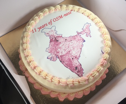
Last weekend OpenStreetMap turned 11 years old, and we celebrated the birthday in Passau, Fukushima, Moscow, Chennai, Taipei, Bengaluru, Beijing, Zurich and London!

The 11th birthday cake arriving for the party in Bengaluru

The 11th birthday cake arriving for the party in Bengaluru

In London this coincided with the OpenStreetMap hack weekend event. Developers came together to do technical work on OpenStreetMap, this time with a “mobile” theme. You can read more about the event on the wiki. Thanks to Rob Nickerson who listed out the various things we worked on. He visited from Birmingham, and then wrote it up on the OSM birmingham blog. We even had a write up on the Ordnance Survey blog, because the event was hosted at the ordance survey “Geovation Hub“. A fantastic venue! We hope to be back there some time, and we hope to see more collaboration between OpenStreetMap and the UK national mapping agency. Also thanks for the pizzas PIE mapping.

Of course technical developments in and around OpenStreetMap are taking place all the time all over the world. These include external applications such as mobile apps, and improvements to more core components. Just today Paul Norman released osm2pgsql version 0.88.1 for example. Several of our contact channels are dedicated to development work, and the engineering working group are keen to find ways of getting more developers involved.

So if you missed the hack weekend or you missed out on the birthday cake, don’t dispair! There’s lots of ways to get involved in OpenStreetMap.

£36k raised, £20k to go

We’re seeing a steady flow of donations large and small coming in. At £36,052 we’re well over half way to our fund-raising goal. A big thanks to Mapzen and Mapbox who kicked off in style, each with a donation of US$20,000!

MapboxMapzen

With awareness spreading quickly now, we’ve doubled the number of people donating just in the past 24 hours! Each supporter can choose to be named on the donations page, and leave a message to us, so if you didn’t do so already, make a donation now!

Find out all about the server funding drive and donate on:

donate.openstreetmap.org

Don’t forget you can also support OpenStreetMap by becoming a member: as an individual or as a corporation.

Fundraising drive 2015

It’s upgrade time! OpenStreetMap is growing, servers are projected to hit capacity by mid 2015. OpenStreetMap is a global community of dedicated and resourceful people, giving their time to make the best map of the world. Those mappers’ contributions are the largest part of the project. However, contributors need infrastructure such as a repository to share their contributions and services that help them make the map and talk to each other. We are raising funds to keep these services running and improve them, so that everyone else can continue making an amazing map.
support-openstreetmap-2015


The Operations Working Group of the OpenStreetMap Foundation manage the core servers of OpenStreetMap and plan server upgrades to scale for our growing community. They make purchasing decisions around server hardware with the budget they have available. With your help, we can continue to grow the OpenStreetMap infrastructure to support the growth of the community and map. See the FAQ for some answers to frequently-asked questions, or get in touch to start a discussion.

MapzenMapboxUpdate: 36k Raised. 20k to go: Big thanks to Mapbox and Mapzen who kicked off the donations each with $20,000!

What else can we do to support OpenStreetMap?

Join us! Aside from funds to upgrade our hardware what we need most are people. Whatever your background – technical or not – you can help OpenStreetMap. Here are just a few of the many possible ways to get more involved:

For individuals:

If you have contributed data to OpenStreetMap, or time to helping organise mapping activities: thank you for everything you’ve already done!
OpenStreetMap only survives because of the work put in by thousands of hard-working and selfless volunteer contributors. If you are one of these people, then you are already doing a great thing for the project.

If you would like to do more, then you can:

  • Join the Foundation and support the body which supports (but doesn’t control) the project. By being a part of the Foundation, your voice can be heard in discussions about how the Foundation is run.
  • Join a Working Group and give your time to solving those issues which require greater commitment. Being on a Working Group, as the name suggests, is hard work and requires diligence, but can make a huge difference to the project.
  • Donate money to the hardware funding drive. Whatever you can spare will be gratefully received and put towards hardware which is necessary for the continued growth and success of the project.

For companies:

Whether you use OpenStreetMap data in your products and services, or are just interested in helping, corporate sponsorship of OpenStreetMap events and hardware helps the project to keep going and be inclusive.

If your company would like to help the project grow and succeed, then you can:

  • Join the Foundation as a corporate member. Your support of the Foundation will be greatly appreciated and publicly lauded.
  • Donate time. Some of your employees might jump at the chance to be more involved with OSM, so why not give them a “20% time” to join a Working Group or contribute time to a project which helps OSM?
  • Donate money to the hardware funding drive. Any contribution will help and is gratefully received.

Corporate Members: Growing Support

Since we reported about the first corporate members joining the OSM Foundation, we have been able to double the number of our members, and welcome Mobile Interactive from Saudi Arabia, maps.me from Russia, Dabeeo from South Korea, Zoho from India, and Siemens from Germany.

Thank you all for supporting our work at the OSM Foundation.

Is your organisation or business using OpenStreetMap? Consider becoming a corporate member today!

Two million OpenStreetMap contributors!

The two millionth account was registered this week, marking another milestone in the continuous and phenomenal growth of OpenStreetMap.

Two million contributors are surveying their neighbourhood, and contributing to the open map of everything. We aren’t done yet. There are still neighbourhoods where we need more mappers, the goal is a mapper on every block.

Celebrate this milestone with a neighbourhood survey to improve your local data. Celebrate further by introducing a friend in another town to OpenStreetMap and teach them how to contribute data from their neighbourhood. We’re still growing. The data is still improving. We’ll get to four million in no time at all with the help of our
friends.

Routing on OpenStreetMap.org

Good news for OpenStreetMap: the main website now has A-to-B routing (directions) built in to the homepage! This will be huge for the OSM project. Kudos to Richard Fairhurst and everyone who helped get this up and running.
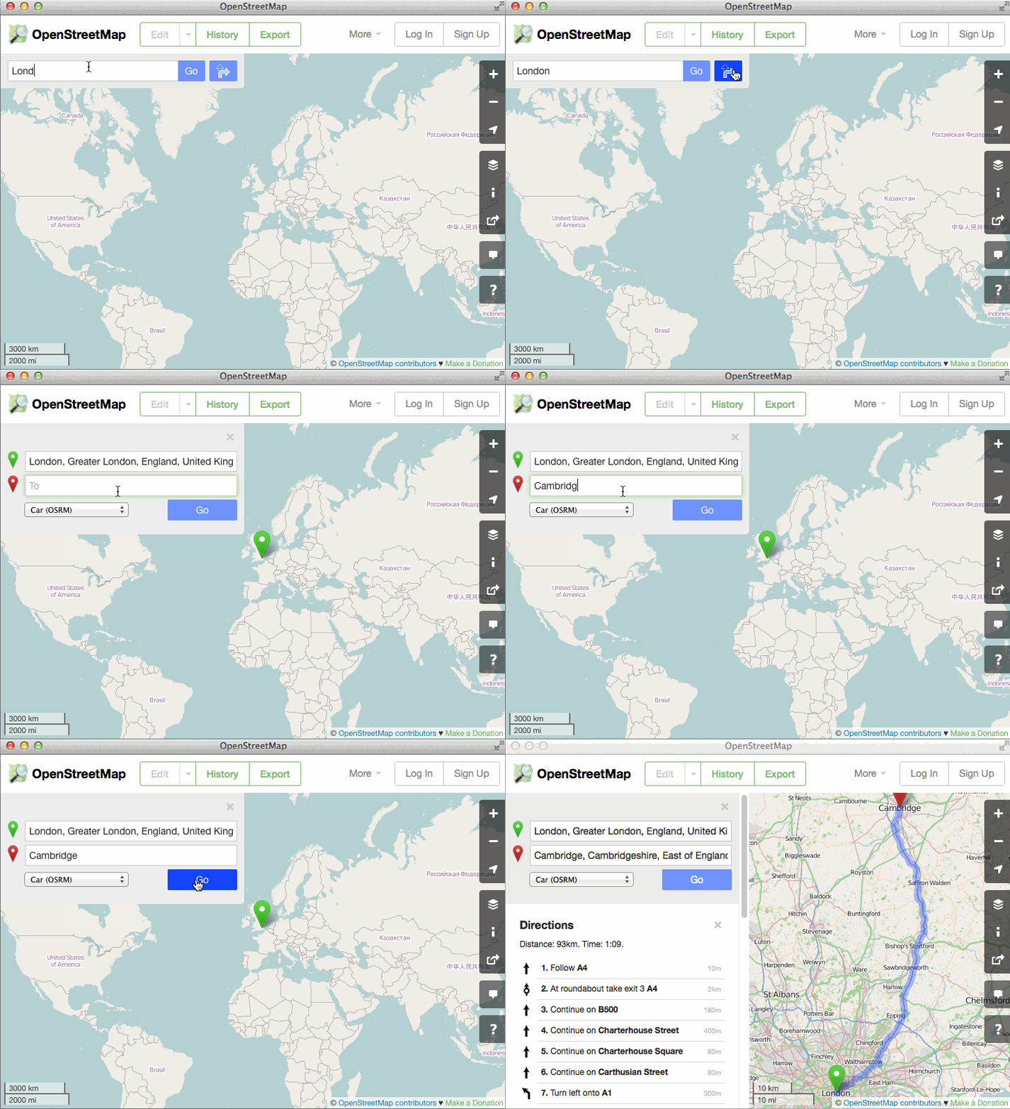
osm-routing

You might be thinking, “Why would this be huge? Isn’t it just a feature that other map websites have had for years now?” Well, the first thing to note is that the philosophy of OpenStreetMap is not to offer a one-stop-shop on our main website, but to create truly open data to empower others to do great things with it. So there has already been fantastic OSM-based travel routing for many years, on excellent websites such as OSRM, Mapquest, Graphhopper, Cyclestreets, Komoot, cycle.travel… the list goes on and on.

But all of those things are on other websites and apps, so people don’t always realise that OpenStreetMap has this power. What this latest development has done is really neat: the OSM website offers directions which are actually provided by third-party systems, but they are included in the main site via some crafty JavaScript coding. So as well as being really handy in itself to have directions available, it helps “first glancers” to see all the things they can do with OSM.

But that’s not what makes it huge.

What makes it huge is the difference it will make to OpenStreetMap’s data by creating a virtuous feedback loop. One of the main reasons we show a “slippy map” on the OpenStreetMap homepage is because people can look at it, see a bridge that needs naming or a building to add, click “Edit” and fix it straight away. That feedback loop is what allowed OpenStreetMap to build up what is now the most complete map of many regions around the world.

But we have a saying: “what gets rendered, gets mapped” – meaning that often you don’t notice a bit of data that needs tweaking unless it actually shows up on the map image. Lots of things aren’t shown on our default rendering, so the feedback loop offers less incentive for people to get them correct. And that goes doubly for things that you never “see” on the map – subtle things like “no left turn” at a particular junction, or “busses only” access on a tiny bit of road, or tricky data issues like when a footpath doesn’t quite join a road that it should join on to. Now that people can see a recommended route directly on the OSM homepage, they have an incentive to quickly pop in and fix little issues like that. The end effect will be OSM’s data going up one more level in terms of its quality for routing. This will empower everyone to do great things with geographic data and getting from A to B.

So find yourself some directions today!


Blog post by Dan Stowell
Mapazonia

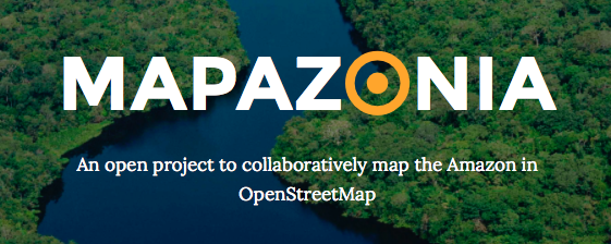
The Latin America OpenStreetMap community was created recently and we decided to organize collective projects on subjects that are common to many countries of our continent. Our first project is Mapazonia.

mapazoniaThe Amazon rainforest includes territory belonging to nine different nations and there are a lot of environmental institutions and governments that need better geospatial data to do their work in that region. Furthermore it’s always good to have quality data in case of a natural disaster or other humanitarian issues. In Brazil there aren’t many editors in this northern region, so there are a lot of towns without any data and some roads to trace.

The Amazon is huge, it has 5 million and a half square kilometres. So initially we are defining some prioritary areas to map in Tasking Manager. There is already one activity in Brazil and another in Bolivia. The main aim is to improve the tracing of the rivers and the road coverage.

Soon we will have more areas in others countries. If you want, you can work in others areas of the Amazon. Put the hashtag #mapazonia in your changeset comments, so we can see your edits in this map.

Visit the site: http://mapazonia.org, follow the twitter account @mapazonia and enjoy mapping the Amazon!

Happy Christmas from OpenStreetMap

OpenStreetMappy Christmas Card

Happy Christmas from OpenStreetMap to all of our contributors.

This sentence doesn’t actually make sense when I think about it. It’s a familiar kind of sentence you might see on a company website, but OpenStreetMap is a project. A collaboration. A map, a database and a community. It’s not a company. I sometimes describe it as a “nebulous internet collective”. OpenStreetMap is all of our contributors. So when we say a Happy Christmas from OpenStreetMap, we are all wishing ourselves a Happy Christmas. Maybe it does make sense. I think I can speak for all OpenStreetMappers in wishing each other a Happy Christmas.

We’re all working together on this project to create an open licensed map of the world, and whether you’ve met other mappers or not, whether you’ve engaged in community discussions or not, you have added your contributions and slotted your piece into the jigsaw of this mighty collaborative endeavour. Please turn to the OpenStreetMapper on your left and wish them Happy Christmas! (Or seasons greetings, happy holidays, happy winter festival… whatever fits)

And a Happy Christmas to all those who are using OpenStreetMap. All those who have seen maps embedded on a website, downloaded maps to their mobile apps, or printed maps out on paper. We hope you enjoyed OpenStreetMap, and of course there’s an easy way to give us a Christmas present in return: Get involved!

New query feature

A couple of weeks ago we mentioned a brand new feature on the OpenStreetMap.org homepage. On the right hand side we have a new “?” button which lets you query the map.

  • On openstreetmap.org, zoom in somewhere
  • Click the “?” button to enter query mode
  • Click the map on something you are interested in
  • Hover over the results, and choose one to find out more

query_tool

When you query a spot on the map, this new tool will retrieve nearby points of interest from the OpenStreetMap database, and let you quickly drill down to all of the detailed tagging information we have in that database.

More than a map

This new tool helps highlight a crucial point about OpenStreetMap. It’s so much more than just a visual map. OpenStreetMap is a rich database of geo-located information, only some of which is visible on the “standard” view of the map. Other information is visible via different layers (such as cycle routes presented on the cycling layer) and all of the data can be viewed by enabling the “map data” layer (also on the layer picker panel) but this query tool offers a new window into the OpenStreetMap data, and a new way to discover all the details our contributors are adding to the database.

For developers this data opens up a world of possibilities. All the data is available to download for free.