[youtube http://www.youtube.com/watch?v=DYinK3g3u-Q?wmode=transparent]
Category Archives: Uncategorized
Video: OSM Stand at Where 2.0
[youtube http://www.youtube.com/watch?v=osOl5Xe8jHU?wmode=transparent]
Video: Haiti and OSM
[youtube http://www.youtube.com/watch?v=QTzfJ5P9qYw?wmode=transparent]
Map Kibera project featured on Flickr Blog
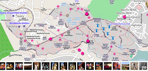
The Map Kibera project (http://www.mapkibera.org/) is putting Kibera
on the map.
Kibera in Nairobi, Kenya, widely known as Africa’s largest slum, remains a blank spot on the map. Without basic knowledge of the geography and resources of Kibera it is impossible to have an informed discussion on how to improve the lives of residents.
Flickr is able to use the map created by Map Kibera and OpenStreetMap
(http://openstreetmap.org) for placing Flickr geotagged photos.
(http://www.flickr.com/map?&fLat=-1.3126&fLon=36.7937&zl=1)
See the Flickr Blog entry here
(http://blog.flickr.net/en/2010/03/31/map-kibera-project-on-flickr/)
and keep up with the Map Kibera (http://www.mapkibera.org/blog/) and
right here on OpenGeoData.
WordPress Plugin OSM v0.9
Michael writes:
After one year I have released the version 0.9 [of the OSM wordpress plugin] which includes a lot of feedback from people using OpenStreetMap in their WordPress blog. The progress of OpenStreetMap maps and the fact, that many people use OpenStreetMap in their blog is motivating to keep the development of OSM-plugin running. Features implemented within the last year are covered by version 0.9:
•
OSM-shortcode generator in WP-settings
•
performance improvements
•
integrated icons
•
several gpx and kml files within one map
•
interface for geocaching
•
simple popup-html-marker with custom field
•
template tags to be added in the WP-theme
•
load non-OSM tiles
•
add controls like scaleline, mouseposition
These pages are related to the OSM-plugin:
•
Download @ WordPress.org : http://WordPress.org/extend/plugins/osm/
•
Plugin @ Fotomobil.at: http://www.Fotomobil.at/wp-osm-plugin/
•
Wiki @ OpenStreetMap.org: http://wiki.OpenStreetMap.org/wiki/Wp-osm-plugin
•
Author @ HanBlog.net: http://www.HanBlog.net
First they ignore you, … Then they use your map in their trade show booth.
Via @wonderchook http://twitter.com/wonderchook/status/11347356355
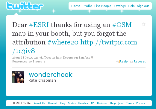
That looks like a lovely Mapnik (http://mapnik.org) rendering of
OpenStreetMap (http://openstreetmap.org) data in the ESRI booth at
Where 2.0, doesn’t it?
Surely the attribution is there, somewhere?
Image of the Week: OSM Workshop at FEATI University

OpenStreetMap Workshop at FEATI University in Manila, Philippines. An
OSMer is teaching geodetic engineering students how to operate the GPS
units and the cake slices for the field mapping is in the foreground. http://wiki.openstreetmap.org/wiki/File:OSM_Workshop_at_FEATI_University_1.jpg
Photo: seav
Nestoria Hiring OpenStreetMap expert(s)

Nestoria was an early adopter of OpenStreetMap and has sponsored every
State of the Map conference to date. Now they are interested in
hiring some OpenStreetMap talent.
From the @nestoria account Twitter

“Want a job where you get to build things with #openstreetmap ? We’re
hiring, join us: http://www.lokku.com/jobs/”
This could be your big break into the world of commercially-backed OSM
contributors. Give them a ring.
From their Job posting on lokku.com
What positions are available?
We’re currently recruiting for:
* Engineering Manager (permanent)
* Technical Product Manager (permanent)
* Engineering Intern (3-6 months)
All positions will, unless stated otherwise, be based in our central
London office (in Clerkenwell).
NYTimes uses OSM in Moscow Bombings Reporting
The first week of Humanitarian OpenStreetMap Team on the ground in Haiti
Robert Soden has written a detailed updated on the first week of HOT in Haiti
In many ways, our outreach efforts been far easier than we anticipated. The GIS teams here have all heard of OSM, and most of them are using the data already in some fashion. Many of the people we’ve talked to over the last week have expressed sincere gratitude to the community for all of its hard work and been more than willing to take time out of their days to talk to us, connect us to the right people, and participate in our training sessions. It’s not because they’re kind people (though they are). The GIS and Information Officers on logbase have a real incentive to work with us because OSM has become such a key dataset here. So they want to learn how to use the data more effectively, give us feedback on how we can improve the tools available to them, and strategize with us about to best fit OSM into their workflows.