Category Archives: Uncategorized

See the OpenStreetMap coverage evolving

There has been a lot of buzz regarding OpenStreetMap during the last days e.g. here or here. However, I learned from several people that they did not understand why interest in OpenStreetMap has increased e.g. here. I thought it is time to visualize some of the recent map development. ITO has done some very nice visualization on OpenStreetMap but I thought a time lapse video on the evolution of the map is missing. Just watch the video for the European map and see if the buzz is justified.

[vimeo http://www.vimeo.com/16148504 w=500&h=283]

There are other versions for Germany only and (slower) versions for Europe in Full HD and Germany in HD.

Even more OpenStreetMap announcements from MapQuest

Antony Pegg, of the MapQuest Open Team, has announced even more
OpenStreetMap related news, including the answer to a mystery from a
short while ago. Ant tells us:

I am very happy to welcome Thea Clay to the MapQuest Open
team.

Antony also tells us about MapQuest implementations of Potlatch 2,
nominatim and some documentation goodies that you will want to see in
his complete article. Go read it now.

http://devblog.mapquest.com/2010/10/21/nominatim-potlach2-and-tiger-edited-ma…

More contributors equals better data

Media_httppoveshamfil_jvxkf

Muki Haklay, senior lecturer in GIS at University College, London has
published another academic study of OpenStreetMap data quality. In
this paper, Professor Haklay shows that Linus’ Law applies to
OpenStreetMap. Linus’ Law states

Given enough eyeballs, all bugs are shallow

as applied to OpenStreetMap. Professor Haklay shows how positional
accuracy improves with more data contributors per square kilometer.
Read his entire article

http://wp.me/p7DNf-6b

Original link to article

http://povesham.wordpress.com/2010/10/21/linus%E2%80%99-law-and-openstreetmap…

Denver to Host 2011 State of the Map

October 21, 2010

Flickr cc by larry johnson

Denver Skyline (flickr cc by Larry Johnson)

The State of the Map (SotM) organizing committee announce Denver, Colorado, USA as the winning bid for the 2011 International conference for OpenStreetMap (OSM). The annual event will be hosted in September 2011.

There were five proposals to host the annual spectacular event: Vienna, Austria, Havana, Cuba, Denver, Colorado (USA), Addis Ababa, Ethiopia, and Tallinn, Estonia. “Deciding on the best location for State of the Map is always one of our biggest and toughest decisions.” says Henk Hoff, chairman of the SotM organizing committee. Among the deciding factors were location, experience of the local committee and outreach potential to new communities.

“Denver is a clear choice because after four great years in Europe, it’s time to branch out and engage with other international communities.” commented Steve Coast, founder of OpenStreetMap.  2011 will host the fifth annual international conference, attracting over 250 people in attendance. Sponsorship details, volunteer opportunities and more information will be available in the near future.

Follow State of the Map on Twitter #sotm

Www.stateofthemap.org

Contact the organizing committee at team@stateofthemap.org.

Wikipedia makes OpenStreetMap more prominent

Media_httpimgurcomai9_zvhie

Wikipedia in German has started to use OpenStreetMap as the default
map in some entries. OSMers / Wikipedians Kolossos and Peter Körner,
announced today, German-language articles with lat / lon coordinates
marked “map” would become a link to display an in-article map. That
map also shows markers to points from similar articles.

These contributors, and others have been doing very interesting things
with OpenStreetMap and Wikipedia. Very nice!

Their original announcement is found on the German OSM mailing list.

http://lists.openstreetmap.org/pipermail/talk-de/2010-October/077812.html

Project of the Week: Shopping Malls

Media_httpwikiopenstr_sxadd

They aren’t glamorous. They might not be pretty. They can be useful,
but there is one seldom-spoken benefit to mapping a local shopping
mall. It is so satisfying.

What is so satisfying about mapping a local mall, or cluster of shops?
It’s a mapping project of Just The Right Size. More substantial than
adding a single POI, faster than adding a village. Mapping a mall is a
nice meal; more than a snack, less than a feast. But perhaps best of
all, mapping a mall is a task that can be completed. Mapping a mall
can be a perfect 30-minute mapping project including survey and
tagging.

Find out more about this Project of the Week, including tagging
suggestions at the project page on the OSM wiki.

http://wiki.openstreetmap.org/wiki/Project_of_the_week/2010/Oct_20

This is your Project of the Week. Submit your own projects or offer
suggestions to inspire and inform other mappers.

http://wiki.openstreetmap.org/wiki/Project_of_the_week/Proposals

Image of the Week: Corine Land Cover in France

Media_httpwikiopenstr_fbmfq

One year after the French land cover import, 69% of the country
includes land cover information.

Details of the French community Corine Land Cover project.

http://wiki.openstreetmap.org/wiki/WikiProject_France/Corine_Land_Cover

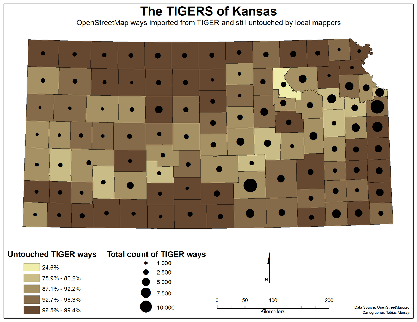
This is a Featured image, which means that it has been identified as
one of the best examples of OpenStreetMap mapping, or that it provides
a useful illustration of the OpenStreetMap project.

If you know another image of similar quality, you can nominate it at

http://wiki.openstreetmap.org/wiki/Featured_image_proposals