Category Archives: Uncategorized

Weekly OSM Summary #55

October 22nd, 2012 – November 5th, 2012

A summary of all the things happening in the OpenStreetMap (OSM) world.

Did we miss something? You can contact us via weekly.osm@googlemail.com

Authors: Pascal & Dennis – (thx @ “Wochennotiz”)

Weekly OSM Summary #54

October 8th, 2012 – October 22nd, 2012

A summary of all the things happening in the OpenStreetMap (OSM) world.

  • The OpenLayers project is calling for funding. You can support this great project here.
  • Tom Hughes added functionality similar to OpenStreetBugs to the main OSM site. You can find some additional information here.
  • Last weekend the State of the Map Scotland was held in Edinburgh. You can find some information at the wiki page or in the tweets by Shaun McDonald.
  • ITO introduced a new video at the State of the Map US conference, which shows edits made in the United States from 2007 to 2012. Martin Davis published some notes about the State of the Map US in his blog.
  • A new streaming replication mechanism has been developed to keep a local OSM database up to date.
  • You can find Alex Barth’s summary and wishlist regarding future work at MapBox, based on the Knight Foundation funding.
  • Do you want to actively contribute to the Leaflet project? Leaflet is an open-source JavaScript library for mobile-friendly interactive maps. Find more about it here.
  • The OSM Inspector has a new layer with routing errors (islands) which is provided by the OSRM Team. Find more information in Dennis’ blog post.
  • Do you want your own OSM Mapper Baseball card? Check out Richard’s idea.
  • Steve Coast introduced the new OSM Commercial Users Conference: http://signup.osmcuc.com

Did we miss something? You can contact us via weekly.osm@googlemail.com

Authors: Pascal & Dennis – (thx @ “Wochennotiz”)

Weekly OSM Summary #53

September 24th, 2012 – October 8th, 2012

A summary of all the things happening in the OpenStreetMap (OSM) world.

Did we miss something? You can contact us via weekly.osm@googlemail.com

Authors: Pascal & Dennis – (thx @ “Wochennotiz”)

Apple Maps

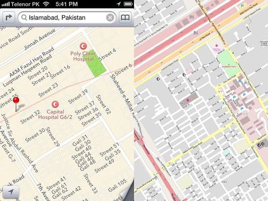
Apple’s new maps for iOS6 make use of OpenStreetMap in some parts of the world. We’re not sure how extensive this use is, but it’s fair to say they are mostly using other sources. Apple have used TomTom as a key supplier of data for example. This means that inaccuracies in apple maps are probably not the fault of OpenStreetMap (contrary to some commentary!) However OpenStreetMap is mentioned in apple’s credits, and we have spotted some areas where we think we can see our data in use. For example here in Islamabad:

We welcome Apple (or anybody else!) using our map data and we’d like to see them use it more.

If you are having problems with the maps on your phone, have a look at an app that only uses current OpenStreetMap data. That way, you’ll know the source. And if you find that the data in your area can be improved or updated, you can improve it! We hope you’ll join us and help make a free and open map of the world. There are so many OpenStreetMap powered apps (click here for a list). If you already have a favourite, please add a comment below to tell us which one it is, and why.

If you’re an iOS developer you can use an OpenStreetMap map within your app. You have a choice of several different libraries to do this: The open source route-me, or offerings from MapQuest or from CloudMade.

If you’re not an iphone user maybe you’re bored of all this apple talk. We do have apps for android and also windows mobile, blackberry, symbian and much more besides. Developers have brought our free and open data to many different mobile device platforms and navigation devices.

Whichever technologies you’re using to view maps, we hope you’ll choose free and open map data from the not-for-profit OpenStreetMap project.

Weekly OSM Summary #52

September 10th, 2012 – September 24th, 2012

A summary of all the things happening in the OpenStreetMap (OSM) world.

Did we miss something? You can contact us via weekly.osm@googlemail.com

Authors: Pascal & Dennis – (thx @ “Wochennotiz”)

Weekly OSM Summary #51

August 27th, 2012 – September 10th, 2012

A summary of all the things happening in the OpenStreetMap (OSM) world.

  • OpenStreetMap changed its license to the ODbL. You can find the official blog post here and the first ODbL OSM planet dump file here. Please re-import your databases accordingly.
  • Congratulations to the newly elected OSMF board members: Frederik Ramm, Henk Hoff and Simon Poole.
  • You will find all recorded sessions of the State of the Map 2012 conference which was held in Tokyo in the OSM wiki.
  • ITO published some great new videos showing five years of edits in Japan and four years of worldwide edits 2008-2011.
  • Christian Quest created a really nice webpage to show live edits that are made to the OSM project. Also the Java tool OSMZmiany shows you the latest changes in the OSM database.
  • A blog post about the HOT at the Tech Camp in Dakar. You can also help the HOT with their new website.
  • Pascal Neis published an “I Like OpenStreetMap” OpenLayers Plugin. It allows the user to leave a like or dislike feedback about the condition of a certain area in OpenStreetMap. You can find more information here and in a blog post here.
  • Martijn van Excel created some nice tools to fix errors created by the redaction bot. Give it a try here.
  • The next OSM Hack Weekend in Germany is planned for the first October weekend.
  • Tom MacWright wrote a blog post about “Running Maps” and his 3D demo.
  • The webpage of the fast OSM Open Source Routing Machine got an update to Leaflet 0.4.
  • The Overpass API offers Augmented Minute Diff files now. You can use it to update an OSM database for a certain area.
  • Are you interested in Mapper Cards? Richard Weait created some.
  • The webpage wheelmap.org has a new dashboard to show some statistics and information about places in several metropolitan areas that are providing a friendly environment for disabled or handicapped people.
  • Stamen Designs published a service Map2Image to create your own OSM printouts. You can try it here.
  • Sage CRM has an OSM Module now, which has been created by the Sage community.

Did we miss something? You can contact us via weekly.osm@googlemail.com

Authors: Pascal & Dennis – (thx @ “Wochennotiz”)

Discount registration for SotM-US in Portland

Martijn tells us about the latest in OpenStreetMap local conferences:

Prices are set to increase for State of the Map – US, in Portland after this Sunday, 16 September 2012, so register now for just $80 ($50 for US Local Chapter members). The conference is right around the corner, happening on October 13-14. It will be great to keep the energy going from Tokyo.

The program is shaping up, with more then 50 sessions in the works.

Some highlights include:

  • Steve Coast, the founder of OpenStreetMap, will kick off the conference with a keynote presentation.
  • Trimet, Portland’s public transportation service agency, will talk about how OpenStreetMap data powers their trip planner.
  • Foursquare and Flickr will talk about how and why they use OpenStreetMap.
  • The World Bank will talk about its work using OSM to help build more resilient communities.
  • The National Park service will show off its new basemap.
  • Community leaders working in Portland, Macon GA, and Indonesia will present on their communities and what they’re doing locally.

The full schedule is due out in the new few days. Watch @sotmus and stateofthemap.us for updates, and be sure to register now to not miss out on the lowest rate possible. Excited to see everyone in October!