OpenStreetMap will complete the license upgrade to ODbL this Wednesday, 12 Septemeber 2012, as announced at the OpenStreetMap Foundation blog.
Category Archives: Uncategorized
Your First ODbL Planet
Michael Collinson, chair of the OpenStreetMap Foundation License Working Group, made an announcement today, at State of the Map 2012. The next OpenStreetMap planet file published will be under the upgraded license, ODbL.
Weekly OSM Summary #50
August 13th, 2012 – August 27th, 2012
A summary of all the things happening in the OpenStreetMap (OSM) world.
- The 8th anniversary of the OSM project has been celebrated with several parties around the world. See some of the birthday cakes here.
- The OSM Data Working Group is beginning to revert some copy & paste remapping that has not been covered by the previously applied bot. You can find some more information here.
- Alex Barth, Kate Chapman, Simon Poole, Frederik Ramm and Henk Hoff are five candidates for the upcoming OSM Foundation (OSMF) board election.
- The Red Cross and the Humanitarian OSM Team (HOT) are tracing Gulu and Lira in North Uganda. You can also find some blog posts about their mapping events here and here. Further, the HOT is working on a tutorship program.
- A nice article about OSM workshops with the Ônibus Hacker in Rio de Janeiro.
- The new Mapmote Chrome-extension allows for starting a JOSM session from a variety of websites. Read more about it here.
- The bikeplaner.org webpage has been created with Open Source software and Open data. You can give it a try here.
- A new article by the London Cyclist about “Google Maps vs CycleStreets: Battle for the best route planner“.
Did we miss something? You can contact us via weekly.osm@googlemail.com
Authors: Pascal & Dennis – (thx @ “Wochennotiz”)
State of the Map US, open for submissions
The deadline for session proposals for the State of the Map USA conference is on Friday, August 31, so submit your session idea soon. The conference will be made up for talks by community members on everything from tools and techniques to working with and contributing to OSM data to showcases of it in use by companies, governments, nonprofits, and everybody to bigger picture discussions of where OSM should be moving in the future.
The State of the Map USA conference will bring together people working with, adding to, and advocating for OpenStreetMap. Our community is filled with people doing interesting, cutting edge, and important work. This is your chance to share it with us all.
You can submit your session proposal here – we just need 200 words or less about what you want to talk about. If you have questions, email Martijn van Exel or hit us up on Twitter at @sotmus.
Weekly OSM Summary #49
July 30th, 2012 – August 13th, 2012
A summary of all the things happening in the OpenStreetMap (OSM) world.
- On August 18th, 2012 the OSM project will celebrate its 8th anniversary.
- A new version of Leaflet (version 0.4) has been launched and includes a lot of new features. Leaflet is an open source library for interactive web maps. A new plugin allows the creation of animated cluster marker groups. Another nice example shows an “Interactive Choropleth Map” for the USA.
- Pascal Neis published a new journal paper about active contributors of the OSM project. The paper can be downloaded here.
- The “Humanitarian Hack Box” is a VirtualBox image with a number of humanitarian server applications. Read more about it here.
- You will find a summary of the work by the “lost mappers task force” here. Their plan was to contact as many contributors as possible who didn’t respond to the license change yet.
- The Royal Mail of Great Britain uses an OSM basemap for their “Gold Postboxes Finder“.
- Martijn van Exel created a redaction map for the entire USA.
- Frederik Ramm and his ideas “About Leadership” of the OSMF.
- A presentation by Ed Freyfogleabout “What’s next in online mapping?“
- The Quadratum WordPress plugin shows all Foursquare checkins on an OSM map.
- The Barnes & Noble Nook tablet will support OSM basemaps. Read more in this article.
- The Map Compare website at bbbike.org increased the number of maps that can be compared. In total there are 52 maps to choose from now. Check it out here.
- A new version of Maperitive has been launched. Read about all the new features and about MBTiles support here and here.
- A “how to” on displaying OSM relations in OpenJump can be found here.
- A new repository for OpenBuildingModels has been launched.
Did we miss something? You can contact us via weekly.osm@googlemail.com
Authors: Pascal & Dennis – (thx @ “Wochennotiz”)
Weekly OSM Summary #48
July 16th, 2012 – July 30th, 2012
A summary of all the things happening in the OpenStreetMap (OSM) world.
- The State of the Map (SotM) schedule, which is going to take place in Tokyo (Japan), has been announced.
- The automated redaction bot process is complete, you can read more here.
- The OSM Inspector (a web based debugging tool for OSM users) has a new layer which shows the data which has been edited by the license redaction bot.
- A request of the Humanitarian OSM Team (HOT) to “Help mapping non-mapped areas of Tajikistan“.
- The latest version of osmconvert (a tool to convert and process OSM data) can create csv files. Read more about the tool and several other options in the wiki.
- A new website shows in which areas members are looking for new OSM contributors. You can create your personal contributor feed too. You can also find the latest OSM contributors of the last two and seven days per country here.
- A step-by-step tutorial for rendering SVG maps from OSM data.
- Nathaniel Kelso created a plugin to load the Stamen maps into the QGI. Read more in the following blog post.
- MapBox introduce a new Open Source Javascript API to create your own browser maps.
- GraphHopper is a new and open source routing engine for OSM road networks. You can find the project on github.
Did we miss something? You can contact us via weekly.osm@googlemail.com
Authors: Pascal & Dennis – (thx @ “Wochennotiz”)
Weekly OSM Summary #47
July 2nd, 2012 – July 16th, 2012
A summary of all the things happening in the OpenStreetMap (OSM) world.
- The ODbL redaction process has been running since Wednesday, July 11th. Past Sunday the bot started working on Western Europe. You can find a really nice webpage, created by Harry Wood, with more information on the current status here.
- You can find a new OpenGoeData blog post about “Building a friendly editor for OpenStreetMap in JavaScript” by Richard Fairhurst here.
- Martijn van Exel developed OSM “Staleness” Maps. More information can be found here.
- The new RSS feed, created by Pascal, informs you about new Mappers in your area. You can check it out here.
- The fastest OSM route planner supports alternative routes now too. Try it out here.
- MapATag is a new OSM tagging game for smartphones: Read more about it here.
- Jan March developed “OSM Buildings“, a JavaScript library that visualizes 3D OSM building data on interactive maps. You can find his source code on github.
- The current weather as an overlay on an OSM map: http://openweathermap.org
- A new blog post by flickr: “Making a Better Map: four months of @OpenStreetMap with @MapBox & @foursquare“. Also a blog post about “Designing an OSM Map Style“.
- GDAL has an OGR driver that can read OSM data from *.osm and *.pbf files. Read more about it here.
Did we miss something? You can contact us via weekly.osm@googlemail.com
Authors: Pascal & Dennis – (thx @ “Wochennotiz”)
Building a friendly editor for OpenStreetMap in JavaScript
It’s been an amazing year for OpenStreetMap and it continues to get better. New users from Foursquare to Apple to Wikipedia to Esri, TV and press coverage around the world, innovative releases from MapBox, MySociety, Skobbler, Stamen, and a thousand others. More people are using OSM data than ever before.
More people are adding to it, too. Our data has grown by 43% in just one year. Most of this is added with two tools: JOSM, the offline editor (Java), and Potlatch, the online one (Flash). Launched in 2006 and 2007 respectively, they’re mature, stable, and enjoyed by thousands of users – the tools that have built the best map of the world.
But how do we harness the knowledge of millions of casual users who are now seeing a ‘Data by OpenStreetMap’ credit for the first time? How do we get people editing on the move, using phones and tablets that can’t run Flash or Java? Can we build something that doesn’t have the power of JOSM or Potlatch, yet is easier for the first-time user to grasp?
Hell yes!
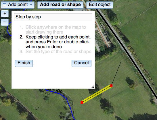
iD is a new project to build a simple, friendly editor for OpenStreetMap – an editor designed entirely for the first-timer to quickly add their street or their local cafe. It’s not a new Potlatch or a new JOSM: it’s ‘an editor for the rest of us’, a stepping stone into OSM.
It’s written in JavaScript: things that required a plugin just a few years ago, modern browsers can do natively, and fast. And with powerful frameworks that even out the differences between browsers, JavaScript can be a joy to program in.
Development is at its really early stages. It doesn’t do much yet: no tagging, no save. It’s not very pretty. That’s where you come in. OSM needs the best, most intuitive map editor there is, and you can help. Coder? Designer? UX specialist? Get involved.
You can read the project introduction, fork the code on github, and read the live docs. Check out the code, play to your heart’s content – tear it up and make it drastically different if you want – and let’s build something to take the OSM editing experience up another notch.
New OpenStreetMap maps website with state-of-the art features by skobbler
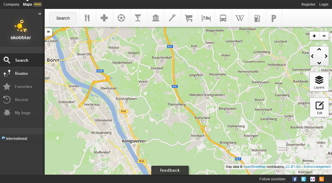
OpenStreetMap is the best map when it comes to attention to detail. However, the experience of the map sometimes lags behind when compared to commercial implementation of the web-based maps. skobbler made an attempt at a new web-based map powered by OpenStreetMap: http://maps.skobbler.com.
There are some innovative features that were always missing with other solutions:
- Auto-positioning via HTML5 browser positioning in Firefox and Chrome (if the user allows it)
- Internationalised style in Germany and the US (coming to many more countries)
- Drag & Drop Route calculation (just move the pins where routes should be calculated)
- Multi-line address search
- POI layers
Performance is very effective due to use of:
- Modern and Fast map JavaScript Engine based on Leaflet
- High-performance map tile loading due to worldwide big chunks of pre-rendered tiles (not only in the US)
Furthermore, there is a new map style with a good compromise of details and clarity. The address search for route calculations is temporarily based on a 3rd party geocoder (in default mode), but allows a single line address entry and very effective address coverage.
Give it a try: http://maps.skobbler.com
Weekly OSM Summary #46
June 18th, 2012 – July 2nd, 2012
A summary of all the things happening in the OpenStreetMap (OSM) world.
- 165 terabyte of new aerial imagery has been released by Microsoft/Bing. You can read their announcement here. You can also find some more general information in our wiki.
- Flickr increased their implementation of OSM map tiles for a few cites. Read the full blog post here. Their map styles are available at github.
- The “Pirate Map” is a new special mapstyle provided by MapBox and created by AJ Ashton.
- The “Swiss OSM Association” was founded during the GEOsummits 2012 in Bern.
- The OSM Mapping project „Via Alpina 2012” has been traveling for 18 days now. They created a blog and a hiking map to keep everyone posted.
- The Android App “KeypadMapper”, which can be used to recording addresses, has been updated. Check out the wiki page.
- The new version 2.12 of Openlayers has been announced. Please be sure to check your current map-pages, since the new version might cause some problems.
Did we miss something? You can contact us via weekly.osm@googlemail.com
Authors: Pascal & Dennis – (thx @ “Wochennotiz”)