Category Archives: Uncategorized

OpenStreetMap opens up to more contributors with easy ‘add a note’ feature

OpenStreetMap, the collaborative map of the world often called “the Wikipedia of mapping”, has unveiled a new feature designed to make it even easier to contribute.

For the first time, anyone viewing the map can suggest a correction – such as a renamed business, a missing footpath, or a changed road layout – without learning to use map editor software.
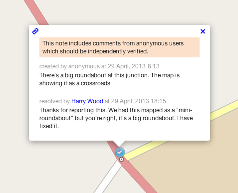
notes screenshot

The corrections will be picked up by OpenStreetMap’s million-strong army of volunteer mappers. A local mapper can visit the location to check the suggested information, and then update the map.

OpenStreetMap’s data is used by some of the biggest mapping names on the web, including Foursquare, Craigslist, Wikipedia, Mapquest, and Apple’s iOS Maps app. It is also extensively used in humanitarian operations, most famously after the Haiti earthquake of 2010.

The new feature is part of a drive to open up OpenStreetMap contributions to more people – so that everyone can add their local knowledge to the map. Later this spring, an all-new HTML5 map editor will be coming to openstreetmap.org; its intuitive controls and clear walk-throughs will encourage more map users to take the plunge and become map editors.

“It’s the detailed local knowledge of our contributors that makes OpenStreetMap so much in demand from web and app developers,” explained Simon Poole, Chairman of the non-profit OpenStreetMap Foundation and a Switzerland-based mapper himself.

“By making it even easier to add to the map, we’re increasing the amount of on-the-ground knowledge we can capture – further distancing OSM from the traditional map data companies and their lack of local expertise.”

To add a note or correction to OpenStreetMap, find your area on openstreetmap.org and click ‘Add a note’ in the bottom right corner.

Background information

Notes are freeform natural text, read by other people, making this is a very simple way to communicate any problems we notice about the map without needing to get to grips with OpenStreetMap and its tagging system. Although this functionality has been available for a while on the third party site OpenStreetBugs, adding it to the main OpenStreetMap site brings it to a much greater audience.

Although it is not necessary to have an OSM account to create a note or comment on it, registered users can see all the notes they have created or commented on, and will receive automatic email notifications if the status of a note changes. OpenStreetMap’s enthusiastic community is its greatest strength, and these notifications facilitate an exchange between the original reporter and experienced mappers.

A full API is available for the notes so that third party sites or apps can query existing notes, create and comment on them – opening up possibilities for mobile bug reporting and fixing. The system is expressly designed for high-quality reports from individual users, not automated error checks or ‘bots’.

OpenStreetMap takes copyright very seriously. Registered users agree not to copy from other maps when signing up, and are requested to verify each suggested correction from non-registered users using ‘on the ground’ information. OpenStreetMap is a map for the people, by the people, and made with personal local knowledge.

Further details are available on the OpenStreetMap community wiki.
Weekly OSM Summary #66

March 25th, 2013 – April 8th, 2013

A summary of all the things happening in the OpenStreetMap (OSM) world.

  • The new OSM iD editor reached version Beta 1. You can also find some slides by John Firebaugh that include some background information of iD here.
  • Is someone interested in taking over the OSM editor Merkaartor? Read more here.
  • A first initial dump of all OSM GPX tracks is downloadable now. You can find additional information in the following thread.
  • Frederik Ramm wrote an article about his work at the OSM Foundation Data Working Group.
  • The OSM Inspector Routing View is now available for the whole world as a single layer.
  • A Youtube video about the “ViaAlpin” mapping party.
  • A new mailing list has been created for discussions and questions about tile-serving.
  • The rendering of the OSM France tile server has a neat visualization for soccer and golf fields.
  • Simon Poole’s QA Map service has a new layer. It can highlight way objects with and without name or address-tags.
  • Matthias created a video about the integration of OSM data into SuperTuxKart game.
  • Some notes from the latest HOT meetings and an update on Kunduz mapping.
  • The website formally known as http://www.pistes-nordiques.org , is now available at: http://www.opensnowmap.org . You can find some additional information here.
  • Several US users had some issues using the Overpass-API. This has been fixed now.
  • How to use OSM map tiles from Stamen or MapBox as basemaps in ArcGIS.com.

Did we miss something? You can contact us via weekly.osm@googlemail.com

Authors: Pascal & Dennis – (thx @ “Wochennotiz”)

Weekly OSM Summary #65

March 11th, 2013 – March 25th, 2013

A summary of all the things happening in the OpenStreetMap (OSM) world.

Did we miss something? You can contact us via weekly.osm@googlemail.com

Authors: Pascal & Dennis – (thx @ “Wochennotiz”)

Join OSM PLUS – the OpenStreetMap Commercial Users Summit

Osmplus

Henk Hoff and I have been working with Steve Coast to develop the idea of a OSM commercial users conference. We have called it OSM PLUS – the OpenStreetMap Commercial Users Summit (http://osmplus.co/). Here is the announcement email:

The OpenStreetMap Professional Large Users Summit is going to be held just after SOTM US, on June 10th in San Francisco at the Marriott Union Square. You can register here. Be quick, space is limited.

OSM PLUS is new and focused on professional users of OSM data and toolchains commercially, academically, in government and elsewhere. It is a paid-for event and we expect it to be more of a conversation than a traditional presentation. Many professional users have similar concerns and expectations for OSM. We want to explore these in an environment focused on coming up with solutions.

Today, OSM is a volunteer-only organization. This focus doesn’t always satisfy the needs of many users. We want to have an open conversation about ways to make OSM better. Because of that, the program will be influenced by those who attend.

PS you can use the code “GPS” to get 20% off the ticket price if you register soon.

Weekly OSM Summary #64

February 25th, 2013 – March 11th, 2013

A summary of all the things happening in the OpenStreetMap (OSM) world.

Did we miss something? You can contact us via weekly.osm@googlemail.com

Authors: Pascal & Dennis – (thx @ “Wochennotiz”)

Weekly OSM Summary #63

February 11th, 2013 – February 25th, 2013

A summary of all the things happening in the OpenStreetMap (OSM) world.

Did we miss something? You can contact us via weekly.osm@googlemail.com

Authors: Pascal & Dennis – (thx @ “Wochennotiz”)

Weekly OSM Summary #62

January 27th, 2013 – February 11th, 2013

A summary of all the things happening in the OpenStreetMap (OSM) world.

Did we miss something? You can contact us via weekly.osm@googlemail.com

Authors: Pascal & Dennis – (thx @ “Wochennotiz”)

Weekly OSM Summary #61

January 13th, 2013 – January 27th, 2013

A summary of all the things happening in the OpenStreetMap (OSM) world.

Did we miss something? You can contact us via weekly.osm@googlemail.com

Authors: Pascal & Dennis – (thx @ “Wochennotiz”)

Some European OpenStreetMap growth statistics

I often get requests about the growth and competitiveness of OpenStreetMap in regards to commercial maps. While OpenStreetMap excels especially when it comes to details, people want to see figures that are more comparable to the commercial maps – mainly navigatable road networks.

I came across some internal evaluations of the recent planet files and thought I just share those figures figures with. These statistics are Europe related and show the values separated for Western and Eastern Europe.

In general we can report a healthy growth over the last 9 months – despite the license change that caused some loss of data.

Osm_drivable_roads_europe_cc

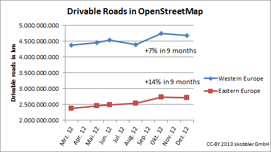
The drivable road network continues to grow in Western and Eastern Europe. While some countries like Germany have more or less reached 100% coverage of the driveable road network, others still have potential. In Eastern Europe I want to stress the growth of Turkey by 39% and Russia by 19%. In Western Europe we see Spain growing by 18% and France by 19%.

Osm_turn_restrictions_europe_cc

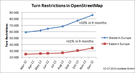
Turn restrictions show a strong growth – Eastern and Western Europe alike. Saturation has not been reached in any country –even Germany has grown by 34%.

Osm_segments_europe_cc

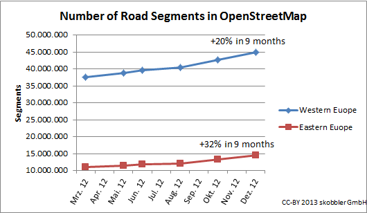
The overall growth of road segments shows an uptake after the license change had been completed.

Overall we see stronger growth in Eastern Europe, which means the gap between Eastern and Western Europe is narrowing.

This is showing just an extract of available data but allows extrapolation with a good confidence level. If you have questions don’t hesitate to contact me.