Author Archives: Mikel
The first week of Humanitarian OpenStreetMap Team on the ground in Haiti
Robert Soden has written a detailed updated on the first week of HOT in Haiti
In many ways, our outreach efforts been far easier than we anticipated. The GIS teams here have all heard of OSM, and most of them are using the data already in some fashion. Many of the people we’ve talked to over the last week have expressed sincere gratitude to the community for all of its hard work and been more than willing to take time out of their days to talk to us, connect us to the right people, and participate in our training sessions. It’s not because they’re kind people (though they are). The GIS and Information Officers on logbase have a real incentive to work with us because OSM has become such a key dataset here. So they want to learn how to use the data more effectively, give us feedback on how we can improve the tools available to them, and strategize with us about to best fit OSM into their workflows.
Humanitarian OpenStreetMap Team Deploys to Haiti
Nicolas and Robert are flying to Haiti this weekend. They need your back. Read the details on Mikel’s weblog
.
Humanitarian OSM Team List
The Humanitarian OpenStreetMap Team now has a mailing list.
During crisis, the HOT list supports coordination among the OSM community, along side appropriate local country lists, and the talk/dev lists when needed. It is the point where disaster responders and affected people can connect directly to members of the OSM community ready to help. In quieter times, the list helps HOT to prepare resources and improve its response.
Note that talk/dev are still good for mobilizing the wide community to a HOT activation, but details of the response can for the most part safely move into this list once we get critical mass of subscribers.
Please join if you are interested in helping HOT, or need HOT services. Thanks!
Haiti OpenStreetMap Response
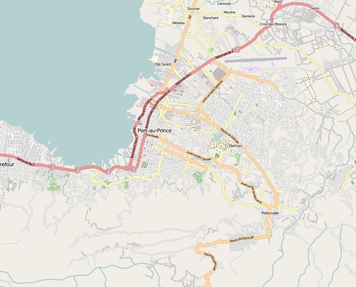
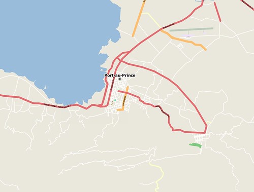
The have been at least 400 OpenStreetMap editing sessions in Haiti since the quake hit. Mostly tracing Yahoo imagery, and gleaning information from old CIA maps. We also just received permission to use GeoEye imagery acquired post-event … that will allow us to tag collapsed buildings. Many relief groups are deploying now, many checking in with the CrisisMappers list (the main locus of the wider humanitarian tech community), and they are making inquiries into OSM data and requests for particular features. Dozens of mappers and developers are lending a hand, coordinating on the OSM Haiti WikiProject and IRC and the OSM talk list … standing up services, including 5 minute extracts in Shapefile and Garmin formats, and maps with hill-shading. Just the start to relief and reconstruction effort we hope to contribute to.
Two images to show how we’ve progressed … the first OSM Port au Prince just now, the second OSM before the earthquake.
I’ll be on twitter with updates … though I’m due to fly tonight to Ireland.
State of the Map Scholarship Winners
Congratulations to the 15 scholarship recipients. We had 35 nominations, from 19 countries, so no easy choice. Thanks to all the nominations .. we hope you can all attend as well.
Will be extremely great to have all these mappers together in Amsterdam!
- Abdel Hassan from Cairo, Egypt
- Anas Maraqa from Palestinian West Bank
- Anatolie Golovco from Moldova
- Arlindo Pereira from Brazil
- Arun Ganesh from Chennai, India
- Asif Rasul from Punjab, Pakistan
- Ciprian Talaba from Romania
- Claudomiro Nascimento Jr from Brazil
- Marloue O. Pidor from the Phillippines
- Freddy Rivera from Colombia
- Giorgi Gujabidze from Tbilisi, Georgia
- H.S. Rai from Punjab, India
- Jorge Luis BATISTA EchevarrÃa from Havana, Cuba
- Julio Costa Zambelli from Vina del Mar, Chile
- Khanh Le Ngoc Quoc from Vietnam
- Nic Roets from Johannesburg, South Africa
InterAction article on OpenStreetMap Gaza
In the latest issue of Monday Developments OpenStreetMap Gaza is a featured case study in the article “Community Contribution of Geospatial Data”.
Monday Developments is the monthly magazine of InterAction is the largest alliance of U.S.-based international development and humanitarian non-governmental organizations .. a growing and important part of the OpenStreetMap community.
Surveying OpenStreetMap in Africa
I’ve had a few inquiries into OSM in Africa recently, put together this brief survey of the action there. If I missed anything, post in the comments.
OpenStreetMap is growing rapidly across all of Africa. Mapping is spreading through local mappers, mappers on vacation, foreign nationals, and remote mapping using satellite imagery. A recent comparison judged that OSM had the most comprehensive coverage of Africa among web mapping services, especially in cities.
Wiki Projects
There are active African wiki projects in Algeria, Burkina Faso, Burundi, Cameroon, Congo-Kinshasa, Egypt, Ethiopia, Ghana, Kenya, Morocco, Nigeria, Rwanda, Senegal, South Africa, Sudan, Tanzania, Tunisia .. and other places no doubt.
Particularly interesting is a project to map the entire Nile.
UN
Bo Robert Pederson of UNICEF has been informally mapping Accra and Nairobi to comprehensive levels, and will be investigating bringing OSM more directly into UNICEF’s activities. There’s strong interest in East Africa in OSM as a component of the East Africa Spatial Data infrastructure.
In cooperation with the UNJLC, Neil Penman and other volunteers from IBM importing UN data sets for Southern Sudan into OSM. We continue to explore opportunies for collaboration there.
Conferences and Mapping Parties
In September 2008, the FOSS4G conference was held in Cape Town. Open Geographic Data and OpenStreetMap emerged
as main themes of the conference. Very successful mapping parties were held in conjunction, including mapping in townships.
Local mappers in Cape Town recently negotiated the release of all street data held by the Cape Town metropolitan region,
to supplement the already stellar OSM coverage there. This link is a quick rendering of the newly freed data.
In July 2008, Wikimania (the Wikipedia conference) was held at the Library of Alexandria in Egypt. OSM was presented to great reception. A mapping party was held in Cairo, and over the last six months Egypt’s maps have grown extremely
rapidly.
2009
Already a strong start to 2009, with new initiatives to promote and use OpenStreetMap in Africa.
DC Based technology consultants Development Seed have active humanitarian mapping projects using OSM in Zimbabwe, Somalia, and the DRC; And they are seeking interns to help with the effort.
The OpenStreetMap Foundation will be distributing donated GPS units to mappers in developing countries.
Not yet formally announced, the codenamed “Mappers Without Borders” project will be providing OSM mapping assistance to humanitarian response and development projects, particularly in Africa. (As a still informal entity, we’ve recently been active in mapping the Gaza Strip.)
Volunteers needed now. OSM for Myanmar disaster relief.
Are you familiar with setting up Mapnik and TileCache, and other components of the OSM stack? Do you want to volunteer time to help support disaster relief in Myanmar?
We’re urgently looking for one or two developers with time, right now, to help set up OpenStreetMap infrastructure in Myanmar.
Due to network constraints, to start they require tile rendering locally. They’ll be collecting data for OSM too, to provide very up to date maps of impacted areas. OSM will be integrated with Sahana. This system could very well be crucial in the relief and recovery efforts, and a great benefit to the people of Myanmar.
Brett Henderson has been working hard setting things up. But we can definitely use more help here. If you are interested to volunteer your technical skills, get in touch with me at “mikel at osmfoundation dot org”.
OpenStreetMap is a Google Summer of Code Project!
We’ve been selected to mentor students this year. We have about six potential mentors so far, and now we need some students. If you are a student, or teach students, or know either teachers or students, and think they’d be good match for OpenStreetMap in the Summer of Code, encourage them to look through our projects, get in touch with us, and apply next week.
Many many thanks go to Spaetz for putting together our application.