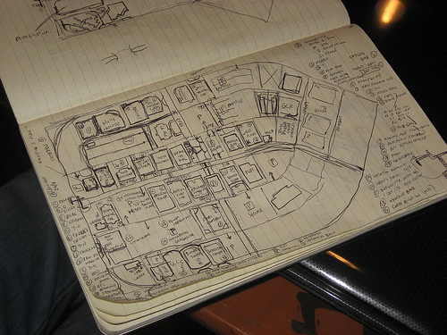
Category Archives: Uncategorized

Project of the Week: Postboxes

Media_httpimgurcomese_dedfe

The humble postbox. Some might argue that postboxes are less
important in a world of email, cell phones and instant messaging.
Some cities are removing postboxes that are seldom used and finding a
cost savings.

http://www.cbc.ca/canada/nova-scotia/story/2010/04/20/ns-mailboxes-canada-pos…

Some would argue that the decline of the postbox means that a postbox
is beneath the notice of a modern, on-line, Web 2.0, open data
project.

And others argue that the decline of the postbox is exactly why
OpenStreetMap contributors care about postboxes; those looking for a
postbox must look further afield to find one.

Learn how to add postboxes and other things that interest you in the
Project of the Week.

http://wiki.openstreetmap.org/wiki/Project_of_the_week/2010/Sep_05

Gregory Marler is an OpenStreetMap contributor who cares about
postboxes and he has provided us with this Project of the Week.
Gregory tells us about finding his OpenStreetMap obsession with
OpenStreetMap and postboxes on his blog.

http://www.livingwithdragons.com/2009/06/my-postbox-obsession

This is your Project of the Week. Make suggestions. Inspire other
mappers. What is it about contributing to OpenStreetMap that
interests you? Postboxes? Bowing alleys? Share your OpenStreetMap
obession by contributing a Project of the Week.

http://wiki.openstreetmap.org/wiki/Project_of_the_week/Proposals

Other Projects of the Week / Humanitarian Mapping
Humanitarian emergencies continue. If you can provide some additional
remote mapping time please consider helping.
http://wiki.openstreetmap.org/wiki/2010_07_Pakistan_Floods
http://wiki.openstreetmap.org/wiki/Project_of_the_week/2010/Aug_15

Postbox photo by Frankie Roberto.

MapQuest adds open routing based on OpenStreetMap data

Antony Pegg announces on the MapQuest Developers Blog that they have
launched an open directions service on OpenStreetMap data.

A couple of Antony’s highlights are:

– This service is powered completely by free, open-source
OpenStreetMap data, instead of commercial data.
– You do not need a key. To repeat: NO KEY. NO SIGNUP REQUIRED. NO
NEED TO AUTHENTICATE – just go use it.

But you should go read the full article

http://devblog.mapquest.com/2010/08/31/mapquest-directions-service-on-openstr…

Thanks and Huge Apology to the OpenStreetMap Community | By the Waze

Two hours ago Steve Coast from OSM contacted us to let us know one of the OSM community members found what he thought was OSM data in our Chile database without attribution. Steve’s crew and Waze’s started investigating IMMEDIATELY across 3 continents and we had answers in 30 minutes.

What we found was a huge disappointment.; we indeed had OSM data which was not from a common base source and was clearly copied.

We have fantastic partners around the world who we partner with for local data. Unfortunately, our LATAM partner Location World had acquired data from an unreliable source who seems to have infringed on OSM, and Location World is now pursuing legal options against them.  While we sort this out, we have pulled all of the Chile data from Waze.  The data has been deleted from the database and should be gone from the Cartouche (our web editing interface) already.  It will take 24-48 hours for the deletion to propagate through the system and down to the clients (sorry Chilean Wazers).

To be on the safe side, we are pulling all the data from this source, in other countries as well: Peru, Uruguay and parts of Argentina, and it should be removed shortly.

The data will be back up again soon, after we have confirmed NO OTHER infringements are there. We are also embarking on a process to more closely review partner data around the world. It’s sad that this happens. We are huge fans of OSM and hope to collaborate with OSM through the new license transition.

So thanks to the OSM members; Ivan Sanchez in Spain and Julio Costa in Chile who identified the problem and we commit to deal with any other suspicion just as fast.  Thanks for Steve for knowing we would never do this willfully and letting us know this has happened in the past.

To map providers around the world, infringement is not only a crime but there is a large community out there monitoring your actions who will work together to find you.

And mostly to the OSM community, we are truly sorry.  We work with our partners to protect their data rights and will now be more vigilant on evaluating their sources.  We value your help and commit to protect your data rights as vigilantly as we protect our partner’s data, removing any infringement on your rights.

Noam Bardin
CEO Waze

This is a really fast & neat example of how a firm can respond to a unintended problem, and work with a community to get it fixed. +1 to waze on this!

Image of the Week: OpenStreetMap in Venezuela

Media_httpwikiopenstr_ykbze

Participantes en la reunión de openstreetmap el Jueves 12 de agosto de
2010 en el CIDA, Mérida – Venezuela

Participants at the OpenStreetMap meeting in Mérida, Venezuela on 12
August 2010.

This is a Featured image, which means that it has been identified as
one of the best examples of OpenStreetMap mapping, or that it provides
a useful illustration of the OpenStreetMap project.

If you know another image of similar quality, you can nominate it on
http://wiki.openstreetmap.org/wiki/Featured_image_proposals

Photo by OSM contributor Hernan Ramirez
http://wiki.openstreetmap.org/wiki/User:HernanRamirez

Project of the Week: Turn Restrictions

One of the most frustrating things about navigating a vehicle through
urban areas are turn restrictions. You want to go right but the sign
says you must go left. Some of the frustration is caused by the
additional driving time and increased number if turns required, but
that frustration is compounded if you didn’t know that the turn
restriction existed in the first place.

With well mapped turn restrictions, you can plan a better route right
from the start, rather than adapting later. The project of the week
is to check and update turn restrictions in your area.

Find out more about checking, adding and fixing turn restrictions,
including tutorials on the OpenStreetMap wiki page for this Project of
the Week.

http://wiki.openstreetmap.org/wiki/Project_of_the_week/2010/Aug_29

This is your Project of the Week. Make suggestions. Inspire other mappers.
http://wiki.openstreetmap.org/wiki/Project_of_the_week/Proposals

No Right Turn photo by TheTruthAbout http://www.flickr.com/photos/thetruthabout/
licensed cc-by-sa http://creativecommons.org/licenses/by-sa/2.0/deed.en_CA

JOSM Tutorials?

Over a year ago I did a handful of JOSM tutorials
( http://wiki.openstreetmap.org /wiki/JOSM ), for example this one on
making a simple edit for the first time using JOSM:
http://russnelson.com/osm/josm-first-edit-ever.swf , or this one on
merging two ways into one:
http://russnelson.com/osm/JOSM-merging-ways.mp4 . JOSM has changed
since then, and I should probably re-do those tutorials. What
tutorials do you think we need to have for JOSM? Are you having
trouble using JOSM? Ask questions in the comments below, and I’ll see
if I can record a video that answers your question.

Image of the Week: Hamburger Sommerdom

Media_httpimgurcomoeh_vpifd

Hamburg has a large carnival three times a year for each 4 weeks. User
mbuege maps all the attractions and fast food stands.

This is a Featured image, which means that it has been identified as
one of the best examples of OpenStreetMap mapping, or that it provides
a useful illustration of the OpenStreetMap project.

If you know another image of similar quality, you can nominate it on
http://wiki.openstreetmap.org/wiki/Featured_image_proposals

Yahoo! Geo-properties at risk?

A recent entry on the Yahoo! Developer Network Blog mentions some
sweeping changes for Yahoo! developers. In part, and relating to geo:

Maps, Geo, and Local

Location-based services are an essential element in web app
development. We will be evaluating all our Geo, Maps, and Local
APIs–updating or shutting down some of them, and working with our
strategic partner, Nokia, on others. We will work with our developer
community to ensure a smooth transition in all instances and we will
share more details about these decisions in September.

Read the full posting at Yahoo! Developer Network Blog.

http://developer.yahoo.net/blog/archives/2010/08/api_updates_and_changes.html

Hat tip: wnoronha