Category Archives: Uncategorized

Mac OS X killed my Garmin 60CSx

OSMer scruss has been doing cool things with OSM, but his GPS receiver
started having problems. Turns out it is the fault of Mac OS X.

So watch out and have a look at his full report for more details.

http://networkedblogs.com/7SEyY

One of the cool things that scruss has been doing is adding wind farm
towers to OSM.

Media_httpimgurcomnwz_behkj

Screenshot from OSM mapnik layer
http://www.openstreetmap.org/?lat=44.06796&lon=-81.64894&zoom=15&layers=M
is CC-By-SA http://creativecommons.org/licenses/by-sa/2.0/

See this contribution in the following changeset

http://www.openstreetmap.org/browse/changeset/5435727

OSM book available in English!

Media_httpimgurcomhpc_hijvg

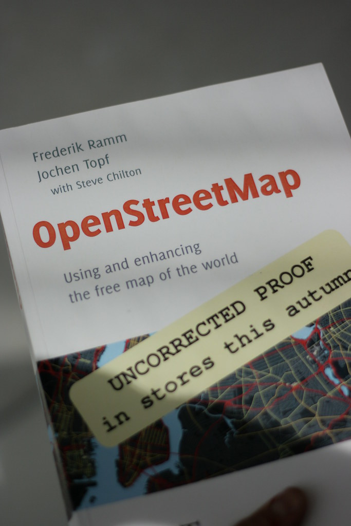
OSMer and co-author, Steve Chilton, reports that the long awaited,
much anticipated, OSM book is coming Real Soon Now. You can pre-order
the book at a discount now, or order it when it becomes available in
five days. I presume that if you wait to order you miss out on the
discount.

http://bit.ly/cj65Rm

This is the OSM book that has seen three editions in German since the
original publication in 2008. I had a peek at a proof version of this
book at the State of the Map in Girona and found it enjoyable and
informative to read. This should be on the bookshelf of every OSMer,
and it will undoubtedly be frequently referred to, dog-eared and
heavily worn.

This is the proof of the book, captured in the wild, at SotM10
by OSMer, Chris Fleming, http://www.flickr.com/photos/chrisfleming/
who licensed the photo CC-By-SA http://creativecommons.org/licenses/by-sa/2.0/

Image of the Week: Staffanstorp building outlines

Media_httpimgurcomyb8_btnzz

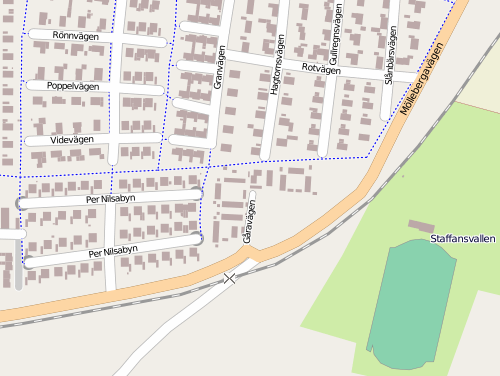
Building outlines in Staffanstorp, Sweden courtesy of the town council
GIS. Uploaded by OSM user lorimar who works in the Staffanstorp
municipality GIS office. You can find Staffanstorp on OSM here.

http://www.openstreetmap.org/?lat=55.6427&lon=13.2117&zoom=14&lay…

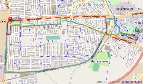
Staffanstorp is doing some interesting things with OSM data. Have a
look at the multi-modal router they have, as well. It is a
comparative router that shows recommended routes for pedestrians,
cyclists, driving and public transit, along with the costs in time,
calories and carbon! Very nice, lorimar.

Media_httpimgurcomt4k_ihjbi

Be sure to switch to display the OSM data layer, it’s much more
detailed than the proprietary data layer. the comparative router was
developed by Staffanstorp’s neighbour, the municipality of Lund.
http://www.lund.se/

http://kartor.lund.se/resejamforaren/start_st.htm

This is a Featured image, which means that it has been identified as
one of the best examples of OpenStreetMap mapping, or that it provides
a useful illustration of the OpenStreetMap project.

If you know another image of similar quality, you can nominate it at

http://wiki.openstreetmap.org/wiki/Featured_image_proposals

Project of the Week: Parks and recreation

Media_httpimgurcom9ge_tmaax

Parks and green spaces add colour to our cities. They provide organic
shapes and textures to the rectilinear world of glass cladding, formed
concrete and rolled asphalt. These urban oases give an opportunity
walk on grass, rather than pavement, to listen to birds rather than
cars, and to picnic in the shade of a tree rather than at a moulded
plastic table.

Let’s add a local park to OpenStreetMap.

Find information on how to add your favourite park to OpenStreetMap,
and a tutorial for newer mappers here.

http://wiki.openstreetmap.org/wiki/Project_of_the_week/2010/Sep_12

This is your Project of the Week. Make suggestions. Inspire other
mappers. What is it about contributing to OpenStreetMap that
interests you? Postboxes? Bowling alleys? Contribute a Project of
the Week and share your interests with other mappers.

http://wiki.openstreetmap.org/wiki/Project_of_the_week/Proposals

Other Projects of the Week / Humanitarian Mapping
Humanitarian emergencies continue. If you can provide some additional
remote mapping time please consider helping.
http://wiki.openstreetmap.org/wiki/2010_07_Pakistan_Floods
http://wiki.openstreetmap.org/wiki/Project_of_the_week/2010/Aug_15

Call for venues: SOTM 2011

Manchester, Limerick, Amsterdam, Girona …. where next? Well, that’s
up to you! The call for venues is now open!

So far, three bids have been presented from three continents. Who
will lead the organizing committee to present a bid for SotM – McMurdo
Station?

To be able to make a good decision your proposal should at least
contain the following information:

* Name of the group or individual applying
* Name, address and short description of the proposed conference venue
* A short impression how the State of the Map 2011 would look like
* Ideas for community-building activities
* Information about the city/region (transport, accommodation, etc).
* An estimate of the costs of the venue and catering

Please have your proposal ready by October 15th 2010.

Get more details and prepare your bids now.

http://wiki.openstreetmap.org/wiki/State_Of_The_Map_2011/Bid

Image of the Week: Happy fourth birthday!

Image of the Week was started four years ago, this week, by
OpenStreetMap contributor OJW.

http://wiki.openstreetmap.org/wiki/User:Ojw

This rendering of Chester was the first image of the week on 02
September 2006.

Media_httpwikiopenstr_hvbui

Since then, Oliver has selected the best images by, for and of the OSM
community, every week and has shown us renderings, contributors,
hardware, animations, products, and more contributors.

Thanks, OJW!

Image of the Week: Survey log book

Media_httpwikiopenstr_cohbs

This is the survey log book of OpenStreetMap user seav and
demonstrates that great mapping can be done with a keen eye, a steady
hand and little in the way of high technology. Until you are ready to
edit and upload.

This page of the log book shows this area of the map.

http://www.openstreetmap.org/?lat=14.5875&lon=121.06185&zoom=17&layers=B000FTF

The photo was taken by OSM user maning, during the Ortigas-Mandaluyong
Mapping Party.

http://wiki.openstreetmap.org/wiki/Ortigas-Mandaluyong_Mapping_Party

Log book photo by OSM user maning http://wiki.openstreetmap.org/wiki/User:Maning
is licensed CC-By-SA http://creativecommons.org/licenses/by-sa/3.0/

This is a Featured image, which means that it has been identified as
one of the best examples of OpenStreetMap mapping, or that it provides
a useful illustration of the OpenStreetMap project.

If you know another image of similar quality, you can nominate it on
http://wiki.openstreetmap.org/wiki/Featured_image_proposals

Who improves the map after a crisis?

Media_httpfarm5static_dgzrh

OpenStreetMap contributor Kate Chapman had a question on her mind and
an instinctual answer. Then she looked in to the numbers to find out
what they said.

There is no question the collaboration of the
OpenStreetMap community in the month following the earthquake in Haiti
was amazing. People from all over the world traced satellite imagery
and imported data to create comprehensive street data for
Port-au-Prince and the rest of the earthquake affected parts of the
country. After reading this Ethan Zuckerman blog post, I wanted to do
some analysis of who exactly made the map. Was it primarily the
already existing OpenStreetMap community? Or was it those who didn’t
want to just text message their ten dollars and actually wanted to do
something to help and OpenStreetMap became a venue for that? This new
group would mostly individuals coming from CrisisCommons during the
many CrisisCamps that occurred during this time. I’ve always stated
that it was the already existing OpenStreetMap community that did the
majority of the map, but I was going on gut instinct, not actual
statistics and facts.

Read the rest of Kate’s analysis, and find out which OSM user was
first to contribute improvements to the Port au Prince map after the
earthquake on her blog.

http://www.maploser.com/?p=279