OSM is all over the new edition of Geographic Information Systems & Science




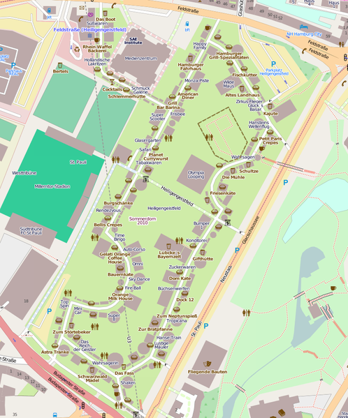
Hamburg has a large carnival three times a year for each 4 weeks. User
mbuege maps all the attractions and fast food stands.

This is a Featured image, which means that it has been identified as
one of the best examples of OpenStreetMap mapping, or that it provides
a useful illustration of the OpenStreetMap project.
If you know another image of similar quality, you can nominate it on
http://wiki.openstreetmap.org/wiki/Featured_image_proposals
A recent entry on the Yahoo! Developer Network Blog mentions some
sweeping changes for Yahoo! developers. In part, and relating to geo:
Maps, Geo, and Local
Location-based services are an essential element in web app
development. We will be evaluating all our Geo, Maps, and Local
APIs–updating or shutting down some of them, and working with our
strategic partner, Nokia, on others. We will work with our developer
community to ensure a smooth transition in all instances and we will
share more details about these decisions in September.
Read the full posting at Yahoo! Developer Network Blog.
http://developer.yahoo.net/blog/archives/2010/08/api_updates_and_changes.html
Hat tip: wnoronha

Your multi-use trail might provide a path for school children with
less vehicle traffic. It might provide a measured distance for
runners to exercise. It might provide educational access to a
protected environmental area or a place to go with the family for some
fresh air and a picnic.
Your multi-use path adds character to your neighbourhood and to the
map. One of the most fundamental contributions that you can make to
OpenStreetMap is to add a new trail, path or road. The Project of the
Week is to add a Trail to OpenStreetMap.
Find details on how to participate in this Project of the Week see the wiki
http://wiki.openstreetmap.org/wiki/Project_of_the_week/2010/Aug_22
Newer OpenStreetMap contributors can find a tutorial on how to add a
trail to OpenStreetMap, along with other tutorials, here
http://weait.com/content/add-trail-openstreetmap
This is your Project of the Week. Make suggestions. Inspire other mappers.
http://wiki.openstreetmap.org/wiki/Project_of_the_week/Proposals
Other Projects of the Week / Humanitarian Mapping
Humanitarian emergencies continue. If you can provide some additional
remote mapping time please consider helping.
http://wiki.openstreetmap.org/wiki/2010_07_Pakistan_Floods
http://wiki.openstreetmap.org/wiki/Project_of_the_week/2010/Aug_15
Trail photo by Mostaque Chowdhury is licensed CC-By.

OpenStreetMap turns six today, so Happy Anniversary and / or Happy
Birthday. Celebrations around the world range from quiet reflection
of individual mappers to raucous demonstrations of mass cartography.
Also, there are sweets.
Congratulations, OpenStreetMap, and here is to many more!
Vector Map GB is an interesting app for the iphone and ipad that lets you show and hide various different bits of OSM data in the UK on the fly. More here: http://itunes.apple.com/gb/app/vectormap-gb/id382291722?mt=8


Six years after OSM was started, the British Isles are finally
starting to look mapped
This is a Featured image, which means that it has been identified as
one of the best examples of OpenStreetMap mapping, or that it provides
a useful illustration of the OpenStreetMap project.
If you know another image of similar quality, you can nominate it on
http://wiki.openstreetmap.org/wiki/Featured_image_proposals
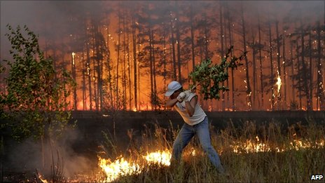
Wildfires, fed by drought and high temperatures, continue in Russia.
http://www.bbc.co.uk/news/world-europe-10883464
http://www.cnn.com/2010/WORLD/europe/08/04/russia.wildfires/index.htmlhttp://…
http://english.pravda.ru/russia/economics/10-08-2010/114551-russia_forest_fir…
The Project of the Week is to mark burned areas on the map using
updated satellite imagery. This Project of the Week requires
familiarity with interpreting low-resolution aerial images and
advanced OSM tools and techniques and may not be suitable for newer
mappers. OSM contributors Komzpa and andrewsh have provided some
background and instructions for advanced mappers.
http://wiki.openstreetmap.org/wiki/Project_of_the_week/2010/Aug_15
The original instructions, in Russian, are here.
http://blog.latlon.org/2010/08/13/kak-risovat-pozhary/
Flooding continues in Pakistan
Flooding, displacement and casualties continue in the monsoon flooding
in Pakistan. Consider continuing to assist with mapping in the flood
affected areas.
http://wiki.openstreetmap.org/wiki/Project_of_the_week/2010/Aug_08
Firefighter photo ©AFP
http://www.bbc.co.uk/news/world-europe-10883464
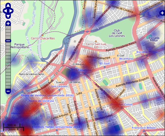
Felipe Barriga Richards has been playing with OSM heatmaps in
OpenLayers. Have a look.
http://blog.felipebarriga.cl/olheatmap_demo/
Map screenshot from Felipe’s site
© OpenStreetMap contributors, CC-BY-SA
http://www.openstreetmap.org/
http://creativecommons.org/licenses/by-sa/2.0/
News from Mike Collinson, Chair of the OSMF License Working Group:
As promised, and long awaited, the next phase of the OSM License
Upgrade has arrived. Phase 2 – Existing Contributor Voluntary
Re-licensing [1] has begun, and you may indicate your acceptance of
the new Contributor Terms for your existing OSM API account. To
accept the terms visit http://openstreetmap.org/user/terms, (you may
be asked to login first), or your user settings page.
Please note that OpenStreetMap is not changing the license on any
published data at this point. Existing contributors are being asked
to permit re-licensing of their data in the future when it makes sense
to do so.
There is no decline button, and no obligation to answer yet. Existing
Contributor Voluntary Re-licensing is for those who wish to accept the
terms and get on with mapping.
We’ll be publishing which users have accepted so that we can all see
the progress in terms of users and re-licensed data.
We hope that you will accept the new Contributor Terms [2] and ODbL
for each of your user accounts if you have more than one.
** Why are we doing it like this? **
What ifs, what ifs. The key is clearly to reduce these. Those that
simply want to get on mapping and accept that we won’t doing anything
daft, can sign up. Those that are worried about data loss and that
the OSMF will make a stupid decision, can wait and see. We’ll show
how much of the database is potentially covered by the ODbL. We’ve got
some help on modelling that, and we’ll aim for at least a weekly
update if not daily. We’ll also make all the data available needed to
calculate that, so if you want to try a different metric or just see
what is happening in your local area, everything will be transparent.
If you support the share-alike concept, I urge you to accept the new
Contributor Terms which provides for a coherent Attribution,
Share-Alike license written especially for databases. If you are a
Public Domain license supporter, we are divided as a community on
which is best and I do urge you to give this one a good try. The
Contributor Terms are expressly written to allow us to come back in
future years and see what is best without all this fuss about
procedure. And if you’d just really like all this hoo-haa to go away
and get back to mapping, well, please say yes.
** Some supporting notes: **
() The key thing is that there are about 12,500 contributors who have
contributed over 98% of the pre-May data.
() I personally really, really want to get a coherent license in place
so that my mapping efforts are more widely used. I also really, really
don’t want us as a community to shoot ourselves in the head and
divide. I pledge to continue working with *both* objectives in mind.
() The License Working Group will not recommend switching over the
license if data loss is unreasonable [3]. We will issue a formal
statement to that effect and are attempting to define better what
“unreasonable” means. A totally quantitative criteria is extremely
difficult to define ahead of actually seeing what specific problems
may arise. But I understand the concern that we are tempted to do
something wild.
() The License Working Group will ask the OSMF board to issue a
similar statement.
() We are working to create a process whereby we can model on a
regular basis how much of the OSM database is covered by ODbL and how
much not. We will make all the data needed to do that public so that
anyone can analyse using their own metrics. Work on this is active and
being discussed on the dev mailing list. You will need:
– An ordinary planet dump.
– Access to history data. A public 18GB “history dump” is available
http://planet.openstreetmap.org/full-experimental/full-planet-100801.osm.bz2.
The intent is to make this available on a regular basis with difffs. A
full re-generation takes several days.
– A list of userids of who has and has not accepted the license. Work
in progress.
() A final vote on whether to switch or not remains an option. But let
us see first if “data loss” really is an issue and what the specific
problems might be.
Regards to all,
Mike
License Working Group
[1] http://wiki.openstreetmap.org/wiki/Open_Database_License/Implementation_Plan#PHASE_2_-_Existing_Contributor_Voluntary_Re-licensing_.28started_10th_August_2010.29
[2] The new Contributor Terms:
http://www.osmfoundation.org/wiki/License/Contributor_Terms_Summary – Summary
http://www.osmfoundation.org/wiki/License/Contributor_Terms – Full
text and links to translations
[3] https://docs.google.com/View?id=dd9g3qjp_76gwvhpcx3 License
Working Group minutes, see Item 7