Category Archives: Uncategorized

OpenStreetMap wins Free Software Foundation award for projects of social benefit

Kate Chapman, holding the Free Software Foundation 2018 award for projects of social benefit, together with FSF founder and president Richard Stallman, who presented the award during LibrePlanet 2019.
Copyright © 2019 Madi Muhlberg, CC-BY 4.0. Image modified.


OpenStreetMap was selected as the winner of the Free Software Foundation 2018 Award for Projects of Social Benefit. FSF founder and president Richard Stallman – who presented the award during the LibrePlanet 2019 conference in Cambridge, MA – mentioned that:

“it has been clear for decades that map data are important. Therefore we need a free collection of map data. The name OpenStreetMap doesn’t say so explicitly, but its map data is free. It is the free replacement that the Free World needs.”

The award was a custom-made piece of art: a golden-looking record that had on its label the four reasons why OpenStreetMap was nominated. It was accepted on behalf of the OpenStreetMap community by Kate Chapman, who went on to thank the Free Software Foundation and the large community of OpenStreetMap contributors. Kate is the chairperson of the OpenStreetMap Foundation – which supports the OpenStreetMap project – and she presented some key milestones of the project during her Sunday talk

“The FSF’s Award for Projects of Social Benefit honors projects that have taken the ideals of the free software movement and applied them to intentionally and significantly benefit society in other aspects of life. OpenStreetMap’s use of free software, freely shared data, and international grassroots collaboration has massively benefited not only the daily lives of individuals around the world but also saved lives through humanitarian uses like improved disaster response. We all owe OpenStreetMap contributors a debt of gratitude, and the FSF is happy to show our appreciation through this award”, said FSF executive director John Sullivan.

Nominations for the award were collected from the public, and then a committee made up primarily of previous winners voted between them. OpenStreetMap is in good company, with previous winners including Tor, Public Lab, SecureDrop, Library Freedom Project, Wikipedia, GNU Health, Creative Commons, the Internet Archive and others. More background information about the award is at https://www.fsf.org/awards/sb-award.

Thanks to all those who contribute to the OpenStreetMap project –
the award belongs to you!


2019-03-30 The post was updated to reflect that the award had on its label the four reasons why OpenStreetMap was nominated, and not the Free Software’s Four Freedoms, as initially mentioned.

What is OpenStreetMap
OpenStreetMap was founded in 2004 and is a international project to create a free map of the world. To do so, we, thousands of volunteers, collect data about roads, railways, rivers, forests, buildings and a lot more worldwide. Our map data can be downloaded for free by everyone and used for any purpose – including commercial usage. It is possible to produce your own maps which highlight certain features, to calculate routes etc. OpenStreetMap is increasingly used when one needs maps which can be very quickly, or easily, updated, such as ambulance services, fire brigades and humanitarian crises response.

What is the OpenStreetMap Foundation
The OpenStreetMap Foundation is a not-for-profit organisation, formed in the UK to support the OpenStreetMap Project. It is dedicated to encouraging the growth, development and distribution of free geospatial data for anyone to use and share. The OpenStreetMap Foundation owns and maintains the infrastructure of the OpenStreetMap project.

What is the Free Software Foundation
The Free Software Foundation (FSF) is a nonprofit with a worldwide mission to promoting computer users’ right to use, study, copy, modify, and redistribute computer programs. The FSF promotes the development and use of free (as in freedom) software — particularly the GNU operating system and its GNU/Linux variants — and free documentation for free software.

What is LibrePlanet
LibrePlanet is an annual conference hosted by the Free Software Foundation for free software enthusiasts and anyone who cares about the intersection of technology and social justice. LibrePlanet brings together software developers, law and policy experts,activists, students, and computer users to learn skills, celebrate free software accomplishments, and face challenges to software freedom.

Organised editing guidelines

OpenStreetMap is powered by its community. While originally supported by individuals, the continuing growth and popularity of OSM have also spawned organised mapping efforts by companies employing mapping teams and unpaid groups like school classes that are directed to work on OSM. 

Organised mapping efforts are an integral part of today’s OSM contribution landscape and, when done well, help make OSM better and more widely used. 

The OSM Foundation has created the Organised Editing Guidelines that summarise expectations, consensus and established conventions based on discussions with the community, members of the OSMF advisory board and humanitarian mapping efforts. Their goal is to provide a framework to both organised mapping initiatives and the communities to encourage good organised mapping. They are not meant to apply to community activities like mapping parties between friends or doing a presentation on OSM at a local club. If you’re not sure whether you should apply them, contact the local community for advice.

The Organised Editing Guidelines can be found here: 
https://wiki.osmfoundation.org/wiki/Organised_Editing_Guidelines

The guidelines have been developed thanks to volunteers of the OSMF Data Working Group, with various rounds of feedback from the wider community, and have been approved by the Board of Directors. Unofficial translations are found here: https://wiki.openstreetmap.org/wiki/Organised_Editing_Guidelines 
You can add your translation there, or contact the Communication Working Group at communication@osmfoundation.org

Sometimes edits made as part of an organised exercise can be problematic, or their accuracy/quality may be disputed by others in the community. As with other disputes, the Foundation’s Data Working Group will respond to organised edits that have gone wrong. While they will intervene for edits that are problematic, not following the guidelines per se is not treated an offense. The overall goal of the guidelines is to provide a framework for ‘sizeable, substantial’ activities: “We wanted something that doesn’t scare casual events off while letting us regulate a geography class gone berserk or a misguided volunteer mapathon.”

en.osm.town: Announcing a new Mastodon instance for OSM (en)

en.osm.town flyer at State of the Map 2018. Photograph by Rory cc-by-sa 4.0

Mastodon is an open source, federated micro-blogging system, with more than a million users. It is similar to Twitter, but open source and spread across many servers. https://en.osm.town/ is a new instance/server focused on OpenStreetMap (there’s already fr.osm.social for francophone OSMers). Like email, this server (“instance”) talks to other servers, so anyone on the “fediverse” can follow and interact with anyone on this server & vice versa. The “local timeline” will only show toots (= tweets) from everyone on the server, so will be full of OSM related stuff. The server was set-up by community member Amᵃᵖanda, who we’d like to thank 🙂

Let’s use something open, and under our control! No adverts, no analytics, no “algorithmic” promoted tweets. 500 characters. Let’s connect on mapstodon! Follow us on https://en.osm.town/@openstreetmap

Other official OSM announcement channels:

Switching to OpenStreetMap!

More and more people and organisations are considering switching to the OpenStreetMap platform for displaying and processing geographic data. There are various reasons why one might like to switch:

Why switch

OpenStreetMap provides open geodata freely to all

Our licence says that you can always copy and modify our data for free.
Your obligations are:

  • Attribution. You must credit OpenStreetMap with the same prominence that would be expected if you were using a commercial provider.
  • Share-Alike. When you use any adapted version of OSM’s map data, or produced works derived from it, you must also offer that adapted data under the ODbL.
    See OSM’s copyright guidelines.

You can make the maps that suit you

With OpenStreetMap, you’re in control. Turning the data into rendered maps can be done any way you like. Want to emphasise cycle routes and play down motorways? No problem (Most other maps don’t even have cycle routes). Want to label subway stops but ignore bus stops? Easy.

Rich, accurate, up-to-date map data

  • Rich: OpenStreetMap might have “street” in the name, but we do much more. Natural features, bus routes, footpaths and cycleways, administrative boundaries, shops, rivers and canals, benches… you name it. See some of our map features (there are more than those listed).
  • Up-to-date: Data on www.openstreetmap.org is constantly updated, and you can get those updates every day, every hour or even every minute if you want.

All this is contributed by our volunteers (over 1,000,000 contributors so far, and growing every day) – the people who really know about their area.

It’s easier than you think

There’s no limit to what you can do with OpenStreetMap. Yet it needn’t take long to get started. You can switch to OSM in under an hour using tools like the easy Leaflet API. Head over to switch2osm.org to find out what possibilities there are.

I want to use OpenStreetMap data

Sure. Read on at using OpenStreetMap.

Can I deploy my own slippy map?

Yes. A slippy map shows map tiles on your web page by using JavaScript code. Please read deploying your own slippy map. Apart from raster tiles there is also the possibility to display a map with vector tiles.

Any advice on using OSM tiles?

Apart from very limited testing purposes, you should not use the tiles supplied by OpenStreetMap.org itself (Tile usage policy). OpenStreetMap is a volunteer-run non-profit body and cannot supply tiles for large-scale commercial use. Rather, you should generate your own tiles or use a third party provider that makes tiles from OSM data.

Docker image

People that would like to self-host may also consider using a docker image (example).

I would like to use the OSM editing API or Nominatim

Please read our

What is considered heavy usage?

If your usage is in any way mission critical for you, you should consider hosting yourself (or paying someone to host for you).

I would like to ask some questions

Sure, go ahead!

  • There is a Q&A platform where your questions might have been already asked and answered. Feel free to ask new ones.
  • We have a forum where there is a dedicated Development subforum.
  • There is a developer mailing list.
  • If you need to reach our Operations Working Group, please note that they are all volunteers and very busy.

I have switched to OSM!

Welcome to our community!

  • We would love if you spread the word about your switch (#switch2osm) on your favourite social media.
  • You can add new OSM-based map services to this list (not for personal websites but map services).

I would like to help!

Great! There are various ways you can help the project.


Sources: switch2osm.org wiki.openstreetmap.org osmuk.org/pinned/reduce-costs-switch-openstreetmap

Recommendations for new (Pokémon GO) mappers by community members

The post below is a modified version of a message written by Spanholz, with input from other OSM community members, aimed at new mappers coming from Pokémon GO. Modified with permission.

Pokémon GO and Ingress changed their base maps to OpenStreetMap in 2017. A lot of you may have discovered a loss in information on the game map. No building shapes, no parks or footways. But you can add them and help to create a free world map.

What is OpenStreetMap?
OpenStreetMap (OSM) is a map that anyone can edit. There are some similarities to Wikipedia, but there are differences too (if you are a Wikipedia contributor please read this). Everything you see in the world could be on one map. Open data, usable by everyone. Niantic uses OSM data for Pokémon GO, Wheelmap users enrich OpenStreetMap to help people with disabilities and Kurviger can show routes for motorcyclists that are more curvy and outside of residential areas. There are many more examples how the data you contribute is used.

How is it different from other online maps?
OpenStreetMap data is open. You are allowed to commercially print maps based on OSM data, with the appropriate attribution on them. You can take the map data and create your own routing engine. You can create your own map style and use it to visualise OSM data. We believe that geographical information should be available in one big database free for everyone.

Isn’t mapping complicated?
No. The world of OpenStreetMap consists of elements such as points (nodes), lines (ways), areas and relations. They get their values through so called tags (like name=Africa). For example a playground could be outlined as an area and tagged as:
name=Happy faces
leisure=playground
opening_hours=10:00-20:00
We can use nodes for small features like wastebaskets or bicycle repair stations. Ways for roads, paths, small waterways. Areas for forests, buildings and ponds.
See popular features that are mapped (for more, search the wiki).

How can I edit?
We have two main editors for mapping with computers, iD, a browser editor, and JOSM, an advanced standalone editor. To add things with your smartphone you can use mobile apps which also display the map you help to enrich. See some of the editors.

What are the most important rules?

  • Don’t use copyrighted sources (maps, databases, photographs).
  • Map what’s on the ground.
  • Have fun creating the best map ever!

Where to find help

  • Search the Wiki, many tags are described there. Read the discussion pages of the tags or search the archive of the tagging mailing list.
  • Look at other parts of the world, where something is already mapped. Look in bigger cities or in Europe, where things are mapped to the greatest detail (yes, there are people who add the colour of waste bins!)
  • Ask! Other mappers will help you, ask on help.openstreetmap.org, on the forum, on country-specific OSM mailing lists and IRC channels or on /r/openstreetmap. You can also find community channels on most social media.

You should know

  • Your changes do not go through an approval process. Please be considerate and only add correct information, as the data is used by drivers, pedestrians, cyclists and even canoeists!
  • You are free to create tags, if you don’t find an appropriate one on the wiki or elsewhere.
  • The wiki is helpful but some pages might have inconsistencies or have suggestions that deviate from common practices.
  • You don’t have to create an official proposal of a new tag on the wiki – but creating one will probably provide you with useful feedback and increase its visibility.
  • Aerial imagery might be old. It could also be offset – compare with gps traces.

What is good mapping?

We have got you covered: Good practices primer!
For example,

    • Don’t use the name tag to describe the object. name=bench is wrong, amenity=bench is right. The name tag should only be used for features with actual names, like schools or restaurants (see Names).
    • Don’t connect landuses with streets. It’s hard to change something afterwards and also confusing.
    • Don’t uncritically delete stuff. First ask the mapper why s/he did something the way s/he did. Maybe you just have old satellite data.
    • OSM data can be visualised in many different ways on various websites or apps – please do not add incorrect tags just to see something rendered on www.openstreetmap.org.

What else?

This website by Pascal Neis shows you other mappers near you, if you want to connect.
Upcoming OSM Events. Maybe there’s a social meet up near you. It’s always good to talk to people face to face.

Have fun creating the best map ever!

Pokémon GO is a hugely popular mobile game which uses OpenStreetMap data to influence “spawn points” within the game. It always takes new folks some time to get to know OpenStreetMap, and we hope Pokémon Go players will stick around to contribute some more.

OpenStreetMap is a world-wide collaborative project aiming at providing free map data, under an open license, to anyone who wants it. Volunteers all over the planet contribute their local knowledge and their time to build the best map ever. You can contribute by improving the map, uploading GPS traces, increasing awareness about the project, editing or translating the wiki, becoming a member of the volunteer Working Groups, donating or joining the OSM Foundation. You don’t have to be a member of the Foundation in order to edit OpenStreetMap.

Spend a Summer of Code with OpenStreetMap!

Google Summer of Code Logo (CC-BY-NC-ND 3.0 Google)

Are you a student who likes to code? Google Summer of Code offers you the opportunity to spend a couple of months contributing to an open source software project – such as OpenStreetMap – and get paid for it!

In 2018, OpenStreetMap has been selected  again as a mentoring organization by Google, continuing ten years of GSoC experience with many successful participants. Our project ideas page lists a variety of possible tasks which use a broad range of programming languages and technology stacks, and cover topics ranging from API development to 3D rendering to public transport. Plus, you’re not limited to that list of suggestions, so if you’d like to contribute to a project from the OSM ecosystem that’s not listed there, feel free to discuss it with us!

Interested? Read up on how to work with us and get in contact with possible mentors and the OSM community as early as possible. Our recommendation is to join the #osm-gsoc IRC channel or post to our developers’ mailing list to introduce yourself and talk about what you want to work on. This year’s application period opens March 12th, start your preparations early to put together a great submission!

Last chance reminders for State of the Map 2018

Castello Sforzesco – Fedewild on Flickr cc-by-sa 2.0

In July the OpenStreetMap community will be coming together for our annual State of the Map conference, this year in Milan, Italy. With planning well under way it is set to be as exciting as ever. Here is a gentle reminder of some upcoming deadlines so that you don’t miss out on the fun.

The deadline to apply for a scholarship is Wednesday, 14th February 2018.

We don’t want high travel costs to get in the way of talented individuals joining the fun. Thanks to the support of our sponsors, scholarships will help bring us together. Apply now for a scholarship to join us.

The deadline to submit your session proposal is Sunday, 18th February 2018.

You are encouraged to submit proposals for 20 minute talks, 5 minute lightning talks, and 75 minute workshops that will result in progress and excitement in the world of OpenStreetMap.

Please apply here!

The deadline for academic track proposals is Sunday, 4th March 2018.

In parallel to the standard sessions, this year State of the Map will run an Academic Track session to showcase the great importance OpenStreetMap has gained within the scientific and academic communities. If you’d like to propose an academic talk you have an extra two weeks.

If you have any questions, please contact us at team@stateofthemap.org.

Thank you,
Your State of the Map team

Recap of Google Summer of Code 2017

With this year’s Google Summer of Code’s recent successful completion, we thought it would be a good idea to recap and shine a spotlight on the individual projects. It’s the 10th year we were participating with success, so thanks to Google for supporting us again, and thanks to the Engineering Working Group for managing our participation this year!

The Google Summer of Code is a program run by Google to match student developers to open source projects. Students may apply to any of the participating projects, based on their preferences or relevant experience. The students that get selected receive a stipend (paid by Google) to spend one summer working on their project, gaining valuable experience while contributing code to real-world projects.

This year, we had five student projects with a really great student developer for each of them and all of them passed, i.e. they all finished their project plan in time. Additionally, there were two OSM-related projects outside of the OSMF umbrella: Indoor Support for Marble based on OSM and a plugin API to display OSM data on NASA Web WorldWind. But we had a bit of bad luck as well: Google gave us the opportunity to select even more students and, while we had applications from two more great students lined up, they didn’t start their project with us due to reasons not within our control.

Anyway, as not everyone was following the students’ work, we thought we should share the outcome of this year’s summer of code with you.

OpenGL Renderer for libosmscout

Let’s start with the first project, which is part of libosmscout, a C++ library for offline map rendering, routing and location lookup. What libosmscout doesn’t have right now is a render path based on OpenGL.

Tim Teulings, the mentor for this project, shared with us that he was very happy to see Fanny work on that task as none of the existing project members had time or the respective know-how, but it was still a highly requested feature. So they felt very lucky to have a great student like Fanny to work on it. What’s more, she even said that she’s keen on continuing to work with that project.

Her part of the library with a small demo application can be viewed on Github and all of her work was continuously merged.

© OpenStreetMap contributors

As you can see, her renderer works quite well and produces beautiful maps. The objective was to support areas, ways, labels and ground to be rendered correctly. In addition to that, the code now supports most of the styling options and works on Linux, as well as on Windows. You can read more about the work and the results on her user diary.

We hope Fanny will stick to her plan to continue to work on libosmscout and stay a part of our great OSM community!

3D Model Repository

The next project we’d like to present to you is the 3D model repository by Pedro (also known as n42k). The project idea has been around for a while, but in the past we either didn’t have a good student or failed to get enough project slots. This year was different and we finally got both!

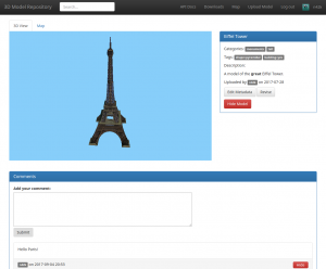
Eiffel Tower Model by joe89v (source)

The task itself is easy to explain: “We want a website that allows uploading 3D models to use for OSM”. But still, there were a lot of decisions to make: The site is now intended for all kinds of models, unlike previous efforts targeted only at buildings. It will initially focus on OBJ as a file format, and will provide unique IDs that can be easily linked in OSM. To make sure that the models fit the needs of the various applications in the OSM ecosystem, developers from two 3D renderers (OSM2World and OSMBuildings) mentored the project together.

Pedro published some of his work in his diary and his highly appreciated code can be viewed at Gitlab. Currently, the mentors are in the process of checking with the OSMF’s Licensing Working Group and others to deal with some details like hosting, branding and some “legal issues” (e.g. with regard to the geocoding guideline), but we’re expecting to see the site go live later this year.

Enhancing JOSM pt_assistant

Another project we want to talk about is the enhancement of the PT Assistant Plugin for JOSM by Giacomo Servadei. While the plugin name suggests this is all about public transport, the scope of this project grew to include hiking and bicycle routes as well.

Besides the extension of scope, Giacomo worked hard to extend the plugin and make it even more useful. For example, it now allows you to sort stops according to the sequence of the ways in the route relations, and it helps you with splitting roundabouts while keeping the route relations that pass over it. But it also has a better check for problems and now reports and suggests fixes, for example gaps of a single way or routes that don’t start or end neatly on a stop_position node near to a corresponding platform node.

You can read about Giacomo’s main results and his detailed timeline in the wiki. It also includes direct links to the dedicated tickets and associated patches. All of his work got merged and you can easly activate his plugin and test the outcome for yourself.

In addition to that, Polyglot, who was Giacomo’s mentor for this project, has written some diary posts about it.

Web-based Public Transport Editor

Dkocich worked on a similar project, but this time it wasn’t about a JOSM plugin. Instead, the goal was to create a website to edit public transport relations without the need to start a full blown editor.

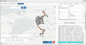
While the editor is not merged yet, this will probably happen soon. Before the finished version of the editor is published by his main mentor Ilya, you can already have a look at his great work and test his version of the OSM Public Transport Editor. You can also have a look at his code on his Github project.

JOSM Refactoring

The next project in this list is all about JOSM’s core code. This project was mentored by Michael Zangl, a former student who had participated in GSoC the two previous years, working on different JOSM tasks – an experience that had allowed him to gain a very deep understanding of JOSM’s core. This year’s project started out as an effort to refactor the menu bar to have a proper API to use, but the project’s goals got extended and modified a bit during the summer.

Bogdans worked hard to dive into JOSM’s codebase and familiarize himself with JOSM. You can have a look at his work on his wiki user page, which also contains a list of tickets he worked on and patches he wrote which got merged.

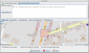
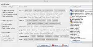
Much of his work is “under the hood”, so unless you’re contributing to JOSM development or plugins yourself, you probably won’t easily notice most of the improvements while working with JOSM. Still, there are some visible updates: Bogdans added the option to search based on presets, and also merged the “Download” and “Download from Overpass API” actions into a single dialog box. Furthermore, there’s a Wizard that helps mappers with constructing Overpass queries now, much like the one known from Overpass turbo.

Again, you can read more about his work on Polyglot’s diary, since he served as a co-mentor.

Summary

This was a great Google Summer of Code again and we’re very happy that we were able to participate. We want to use the opportunity to thank all the students for their work and we’re hopeful that you as a user will benefit from one of them as well. In addition to that, we’d also like to thank the mentors for spending their spare time to help the students finish their tasks and the EWG for doing the administration of this year’s GSoC.

After the conclusion of this year’s GSoC, we performed a small survey among our mentors to gather feedback, and even though some of them had to invest considerable hours in it, they unanimously responded that it was worth their time and that OSM should participate again next year. So we conclude by tasking the EWG to apply again next year!

Choose the best bloggers and mappers for the OSM Awards 2017

The community voting for the OpenStreetMap Awards 2017 continues! We have 45 nominees, any number of which you can support, and only nine of them will receive the award. This is a hard choice, and to help you, we are continuing the series of posts about the work nominees did.

Influential Writing Award

For the best tutorial, documentation, blog or a blog post. A text or series of texts that attracted many new people to OSM, provided an interesting outlook on the project, or inspired the community to do better things.

  • Carto’Cité: there are few blogs about GIS in non-English languages, and we are lucky to have this one. Carto’Cité is a geomatics agency in Nantes, France, and not only they do work for their clients, they also regularly publish very detailed tutorials for using OpenStreetMap data in QGIS, uMap and other open tools.
  • : being the most visible member of the Belgian community, he organizes local events and publishes a very diverse and useful diary. He writes in detail about analysing OSM data, using data from government, about impact of mapping parties and Missing Maps events, and interviews interesting people.
  • BushmanK: he has posted many thoughtful diary posts about various aspects of OpenStreetMap, which make you question everything: mapping time zones, adding name translations, tagging man-made structures, using signs for names, and even governance of the map.
  • Ramani Huria: they are the very active community in Tanzania, and their blog is full not only with event reports, but with tutorials on JOSM, QGIS and mapping techniques, in both English and Swahili. Their articles are useful both to people from their country and to everyone else.
  • Arun Ganesh: better known as PlaneMad, he is the leader of the Mapbox’s data team, always watching for errors on the map and analysing data, examining mapping applications or styling maps in his spare time. All of that you can see in his blog, complete with diagrams, screenshots and funny pictures.

Greatness in Mapping Award

For significant contributions to the map data, or exemplary mapping: micro-mapping, clean-up, mapping towns from scratch, proper imports.

  • xscvxc: while most of us map cities we live in, xscvxc is busy mapping small towns in his region, not on the radar of urban mappers. In his 2.8 million edits he perfected his home town and proceeded to improve many other rural areas of Novosibirsk Region in Russia.
  • Russell Deffner: to predict and prevent malaria disease spread, you need all the settlements and their buildings on the map. Russel has coordinated a global effort to map more than 4 million buildings across 7 countries, which is a lot. Read about this on the HOT project page.
  • : in March there were a quarter million old-style multipolygons, and now there is none. All thanks to Jochen, who is coordinating the continuing series of polygon fixing tasks, complete with statistics, maps and explanations. Subscribe to this github issue to learn about new tasks, and help him make the OSM data simpler to use.
  • : for a year and a half he has been actively mapping cities in Nepal: Kathmandu, Pokhara, Tikapur and others. There are few days he goes without adding something to the map: even today he’s drawn a lot of school buildings there.
  • katpatuka: if you’ve been in OpenStreetMap for at least a year, you’ve sure seen edits by katpatuka. In his 10 years of editing he made 30 million changes, mostly to Turkey and China. There is no point in showing his editing heat map: he has touched almost every point on Earth, focusing on less-developed areas. And he had not slowed down: it’s like if everyone else leaves OSM, thanks to katpatuka the map will still be complete eventually.

We hope you have made your choices — head to the OSM Awards website and mark people and groups that you think did the best job the previous year. You can choose any number of nominees, and the choice can be changed at any moment before the voting closes on the 16th of August. We’ll return next week to look at the regional categories.

OpenStreetMap Featured Images

Every week we choose a new OpenStreetMap “featured image”. Here’s our images of April, May and June:

2017 2017 2017 2017 2017 2017 2017 2017 2017 2017 2017 2017 2017

(click to view bigger images and explanations)

An OpenStreetMap Featured Image (otherwise known as “Image Of The Week”) is chosen each week. Recently we’ve been putting them out on twitter and facebook, so you’ll most likely have seen them there. We’re still a little behind on posting them, so consider this a preview! But featured images also appear each week on the wiki main page.

If you come across an image which you would like to put forward as image of the week (either your own image or somebody else’s), head over to “Featured image proposals” and edit that page to make your suggestion there. Anyone can join in with the process of investigating, improving and discussing the suggestions, and picking an OpenStreetMap image of the week each week. If wiki editing is difficult for you, just email CWG with your suggestions.