Category Archives: Uncategorized

OpenStreetMap editor Potlatch 2 launched

Media_httpwikiopenstr_fwaej

You may have noticed something new in your OpenStreetMap editing
today. Potlatch 2 has now gone live on OpenStreetMap.org. Potlatch 2
is a complete rewrite in ActionScript 3 using the free Flex 3
compiler. Potlatch 2 rendering uses MapCSS and RichardF’s halcyon
rendering library. It’s new. It’s Open Source. And it’s on
OpenStreetMap.org

But, why didn’t I notice it?

That’s a fair question. You might not have noticed Potlatch 2 on the
main OpenStreetMap.org web site because it is now an editor option.
That’s right. If you hover over the Edit tab, you can select from
Potlatch or Potlatch 2. JOSM is also an option if you have JOSM open
with the remote control plugin active. You can set a default editor
in your API user preferences. [Support for the Merkaartor remote
control plugin is coming soon.]

Media_httpimgurcomerc_fxzgk

Potlatch 2 may not be the right editor for everybody. There will be
bugs discovered, and removed as development continues. Consider
adding Potlatch 2 to your editing arsenal, and be sure to report any
bugs you find.

The amazing team behind Potlatch 2 and this update to the web site
includes some of the same people who keep OSM running and have been
making OpenStreetMap great for years.

Richard Fairhurst http://wiki.openstreetmap.org/wiki/User:Richard
Andy Allan http://wiki.openstreetmap.org/wiki/User:Gravitystorm
Tom Hughes http://wiki.openstreetmap.org/wiki/User:TomH
Dave Stubbs http://wiki.openstreetmap.org/wiki/User:Randomjunk
Matt Amos http://wiki.openstreetmap.org/wiki/User:Matt

And thanks extend to many others including all of those who keep OSM
running day to day, all of the Potlatch 2 testers, documenters, and
MapQuest for sponsoring Andy’s development time over the past few
months.

You can see a graphical representation of the development of the
Potlatch 2 code here:

Media_httpwikiopenstr_abcen

Congratulations to the entire Potlatch 2 team and thanks for this new editor!

Developers wishing to contribute to Potlatch 2 will find the code in
svn and can hack on it with the Open Source Flex compiler.

http://svn.openstreetmap.org/applications/editors/potlatch2/README.txt

Open an editing session in Potlatch 2

http://www.openstreetmap.org/edit?editor=potlatch2

Image of the Week: OpenStreetMap data in svg layers

Media_httpimgurcompjc_aimjg

A screenshot of Illustrator showing a SVG file produced by Maperitive.
This new functionality is available in the newest release of
Maperitive.

This is a Featured image, which means that it has been identified as
one of the best examples of OpenStreetMap mapping, or that it provides
a useful illustration of the OpenStreetMap project.

If you know another image of similar quality, you can nominate it at

http://wiki.openstreetmap.org/wiki/Featured_image_proposals

Weekly OSM Summary #3

11/21/2010 – 11/28/2010

Every week a lot of things are happening in the OpenStreetMap (OSM) world. It can be hard to keep track of all the different communication channels and don’t miss any important news. That’s why we’ve created a short summary of all the news here. Enjoy!

For more news, especially regarding new tags and wiki pages, you can check-out the community-updates over here.

Authors: PascalJonas, Matthias & Brice.
We missed something? You want to help us collecting the news for next week’s issue? 
You can contact us via mail or Twitter.


Humanitarian OpenStreetMap Team: Proposal for Knight News Challenge

Media_httphotopenstre_fbghv

The Humanitarian OpenStreetMap Team includes OpenStreetMap
contributors who are particularly interested in the intersection of
OpenStreetMap and humanitarian relief. HOT is applying for a Knight
News Challenge grant. And the grant-writers among them seek feedback
from the larger OpenStreetMap community.

Since the greater OpenStreetMap community has been such a
part of mapping in Haiti before submission we want to get your
feedback. Please look at it and let us know what you think.

Read the full text and their proposal here:

http://hot.openstreetmap.org/weblog/2010/11/hots-proposal-for-the-knight-news…

Project of the Month: Wheelchair accessibility

Navigation, maps and accessibility extend beyond the shortest drive to
a shop and the opening hours. The Project of the Month for December
2010 is to include wheelchair accessibility information as part of
your mapping. Learn more about how to map your maps more accessible
or the project page.

http://wiki.openstreetmap.org/wiki/Project_of_the_week/2010/Nov_24

This is the a Project of the Month. Project of the Week returns
next week, while PotM will continue until January. These projects
inspire mappers to contribute data they might not have considered
previously, and allow us to be inspired by the projects of other
mappers.

This is your Project of the Month. Make suggestions. Inspire other
mappers. What is it about contributing to OpenStreetMap that
interests you? Postboxes? Bowing alleys? Share your OpenStreetMap
obession by contributing a Project of the Month.

http://wiki.openstreetmap.org/wiki/Project_of_the_week/Proposals
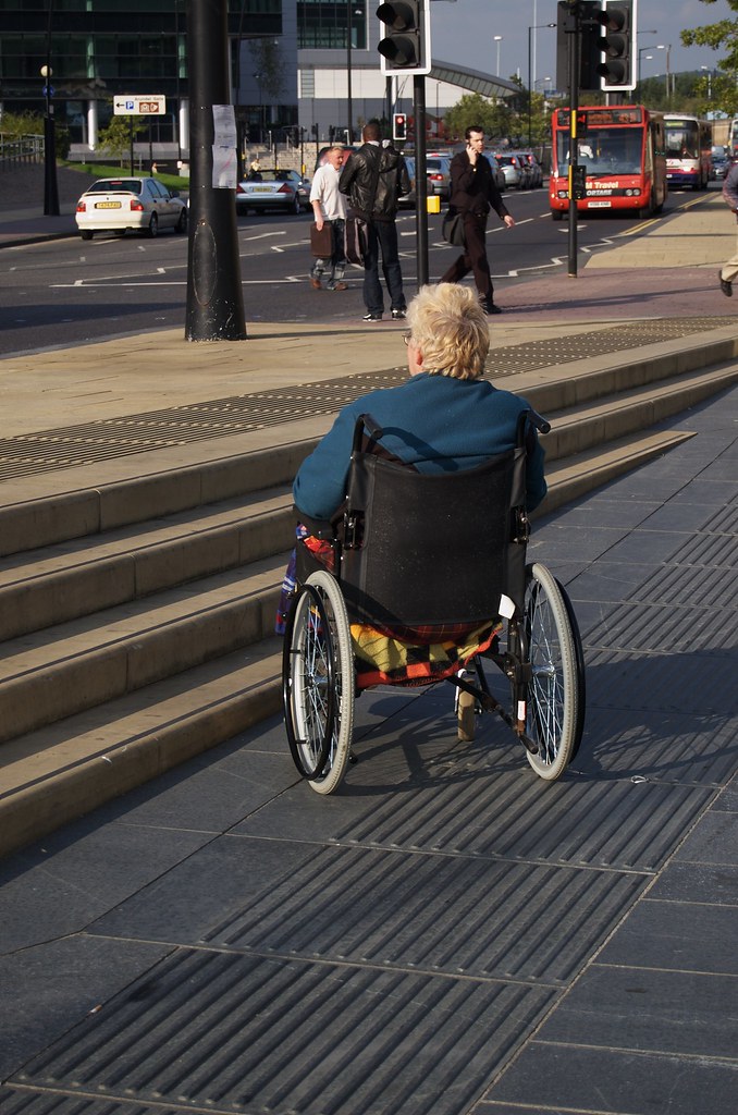
Steps and chair photo by Tim Parkinson
http://www.flickr.com/photos/timparkinson/
is licensed CC-By http://creativecommons.org/licenses/by/2.0/deed.en

Image of the Week: OpenStreetMap more prominent on Wikipedia

Media_httpimgurcomia6_rdqva

OpenStreetMap from the no:Operahuset i Oslo Wikipedia page, showing
no:Kontraskjæret as a pop-up link. Screenshot of the Wikipedia page.
See the full size image on Wikipedia or here,

This is a Featured image, which means that it has been identified as
one of the best examples of OpenStreetMap mapping, or that it provides
a useful illustration of the OpenStreetMap project.

If you know another image of similar quality, you can nominate it at

http://wiki.openstreetmap.org/wiki/Featured_image_proposals

OpenStreetMap founder Steve Coast joins Bing

Media_httpiimgurcom4n_xmwoe

When Steve Coast, founder of OpenStreetMap and co-founder of CloudMade
announced in October that he was leaving CloudMade there was no
expectation that he would be idle for long. In the interim he decided
to revolutionize transit data by founding http://transiki.org/ took
some hang gliding lessons and by the way co-organized a great
geo-unconference in Denver last weekend.

But what else has Steve done lately?

He’s decided to revolutionize Bing Maps.

As announced today on his blog Steve Coast will be joining Microsoft
property, Bing Maps as Principal Architect on Bing Mobile.

And Microsoft is donating their global aerial imagery to OpenStreetMap
contributors for use in improving OpenStreetMap.

You will certainly want to read the complete announcement at the following link.

http://blog.stevecoast.com/im-working-at-microsoft-and-were-donating-ima

Update, further information on the Bing blog, here,

http://www.bing.com/community/site_blogs/b/maps/archive/2010/11/23/bing-engag…

Congratulations, Steve!

Law and the GeoWeb

I’ll be there…

Law and the GeoWeb
==================

A workshop on “Intellectual Property and Geographic Data in the
Internet Era” sponsored by Creative Commons and the United States
Geological Survey (USGS) in conjunction with the annual meeting of
AAG, April 11, 2011, Seattle, Washington. The workshop will be held at
the campus of Microsoft Research, and will be streamed live on the
Internet.

This workshop will focus on intellectual property issues with
geographic data, exploring situations when users and creators ranging
from individuals to local, state and federal agencies as well as
private companies and non-profits create, share and reuse geographic
information from different sources over the Internet in their
projects.

For more information, please see http://punkish.org/geoweb/index.html
or search on Twitter for #lawandgeoweb

Rationale
=========

U.S Copyright Law protects tangible original works with creative
content but the law also ensures that facts, that is, data that are
discovered rather than invented, remain free for everyone’s benefit.
This ideas/expression dichotomy creates a lot of issues in the
Internet age when information is very easily created, shared, used and
reused.

With inexpensive computing and networking power available to everyone,
geographic datasets are increasingly being created, shared and used by
individuals, grassroots organizations, and private corporations. These
data come with different expectations with regards to how they may be
used resulting in a hodgepodge of licensing and contractual
obligations that hinders data interoperability. Mixing data of
different provenance creates new data with typically more restrictive
licensing conditions. Public agencies may be unable to mix licensed
data with government data due to restrictive licensing terms of the
resultant dataset, and thus, may be unable to capitalize on and
benefit from user-generated content.

Workshop Structure
==================

The current line-up of speakers from federal, state and local
agencies, Creative Commons, grassroots agencies, intellectual property
lawyers, the geospatial industry, and research and academia includes:

* Ed Arabas, National States Geographic Information Council
* Greg Babinski, King County, State of Washington
* Michael Brick, Microsoft Legal, Bing Maps
* Steve Coast, Founder, OpenStreetMap 
* Kari Craun, Director, National Geospatial Technical Operations, USGS
* Ed Parsons, Chief Technologist, Google Maps, Google
* Diane Peters, General Counsel, Creative Commons
* Tim Trainor, Bureau Chief, Geography Division, US Census Bureau
* Paul Uhlir, Director, Board for Research, Data and Information, NRC

The format of the workshop will encourage discussion and participation.

Participate
===========

To ensure those directly involved in the topic get a chance to attend
the workshop, attendance is based on a short application form
accessible at http://punkish.org/geoweb/participate/in_person/index.html.
Deadline for applying for the workshop is December 18, 2010. Selected
applicants will be informed by January 15, 2011.

Attendees will also be able to submit longer papers for publication in
a special issue of the peer-reviewed, completely free and open access
online journal “International Journal of Spatial Data Infrastructure
Research” published by the Joint Research Centre of the European
Commission.

Logistics
=========

The workshop is organized in conjunction with the AAG annual meeting.
The workshop will be held on the campus of Microsoft Research, and run
from 1 PM to 5 PM on Monday, April 11, 2011.

There is no fee for this workshop and participants do not have to
register for the AAG Annual Meeting. The workshop is limited to 50
participants to facilitate discussion.

Proceedings of the workshop and selected longer papers will be
published in a special issue of the open-access International Journal
of Spatial Data Infrastructure Research published by the Joint
Research Centre of the European Commission.

Contact
=======

Please contact either Puneet Kishor, Creative Commons
[punkish@creativecommons.org] or Barbare Poore, USGS
[bspoore@usgs.gov] if you have any questions.

Weekly OSM Summary #2

11/14/2010 – 11/21/2010

Every week a lot of things are happening in the OpenStreetMap world. New map renderings are created, new services are released and the map gets better and better every day. It can be hard to keep track of all the different communication channels and don’t miss any important news. Since we read most of those channels anyway, we decided to collect all the things we find newsworthy enough to list them at the end of the week here. To every news we’ve attached a short description and you can always find more information on the linked websites. Enjoy!

For more news, especially regarding new tags and wiki pages, you can check-out the community-updates over here.

Authors: PascalJonas, Matthias & Brice.
We missed something? You want to help us collecting the news for next week’s issue? 
You can contact us via mail or Twitter.