I had the chance to have a chat with all the board members during our Pisa meeting. See Henk about OpenStreetMap, SOTM and the community.
Category Archives: Uncategorized
Project of the Week: Police station

When you need to find a police station, you need to find it Right Now!
The Project of the Week is to map your local police station.
http://wiki.openstreetmap.org/wiki/Project_of_the_week/2011/Jan_05
This is the first Project of the Week for 2011. Last week we
announced the first Project of the Month for January 2011, mapping
libraries.
http://wiki.openstreetmap.org/wiki/Project_of_the_week/2010/Dec_29
This is your Project of the Week. Make suggestions. Inspire other
mappers. What is it about contributing to OpenStreetMap that
interests you? Postboxes? Bowing alleys? Share your OpenStreetMap
interests by contributing a Project of the Week.
http://wiki.openstreetmap.org/wiki/Project_of_the_week/Proposals
Police station photo by Elliot Brown http://www.flickr.com/photos/ell-r-brown/
is licensed CC-By http://creativecommons.org/licenses/by/2.0/deed.en
Image of the Week: OpenPisteMap

Snowsports maps from openpistemap.org with contours and hillshading.
Hitting the slopes this winter? Check out WikiProject Piste Maps
http://wiki.openstreetmap.org/wiki/WikiProject_Piste_Maps
This is a Featured image, which means that it has been identified as
one of the best examples of OpenStreetMap mapping, or that it provides
a useful illustration of the OpenStreetMap project.
If you know another image of similar quality, you can nominate it at
OSMF Board Interview Series – Mikel Maron
I had the chance to have a chat with all the board members during our Pisa meeting. See Mikel about OpenStreetMap, humanitarian projects, HOT and Haiti.
Project of the Month: Library

Libraries are repositories of information, places of learning and of
research. One of the ancient libraries, the Library of Alexandria is
credited with comparing different versions of books with empirical
standards which became the beginnings of the scientific method.
Libraries are filled with adventures of discovery wrapped in layers of
shush.
The Project of the Month is to add your local library to the map.
http://wiki.openstreetmap.org/wiki/Project_of_the_week/2010/Dec_29
This is the a Project of the Month. Project of the Week returns
next week, while PotM will continue until the end of January. These projects
inspire mappers to contribute data they might not have considered
previously, and allow us to be inspired by the projects of other
mappers.
This is your Project of the Month. Make suggestions. Inspire other
mappers. What is it about contributing to OpenStreetMap that
interests you? Postboxes? Bowing alleys? Share your OpenStreetMap
obession by contributing a Project of the Month.
http://wiki.openstreetmap.org/wiki/Project_of_the_week/Proposals
New York Public Library photo by Gabriel Rodriguez
http://www.flickr.com/photos/chewie/
is licensed CC-By-SA http://creativecommons.org/licenses/by-sa/2.0/deed.en_CA
Image of the Week: Urban accessibility map
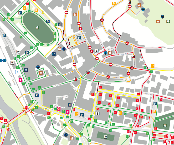
This is an extract of the printed paper map of urban accessibility of
Castelfiorentino. The printed paper map is a static view of urban
accessibility as the 30th of August 2010 and it is one of the outcomes
of the participatory process “Libero accesso…accesso libera
tutti!!”. The full printer map file is here The up-to-date
accessibility map is published on the web at accessoliberatutti.it
where participant and citizens can keep contributing. Further
information and several links are available on the project page:
http://wiki.openstreetmap.org/wiki/Libero_Accesso…Accesso_Libera_Tutti!
This is a Featured image, which means that it has been identified as
one of the best examples of OpenStreetMap mapping, or that it provides
a useful illustration related to the OpenStreetMap project.
If you know another image of similar quality, you can nominate it at
Weekly OSM Summary #6
12/12/2010 – 12/23/2010
Every week a lot of things are happening in the OpenStreetMap (OSM) world. It can be hard to keep track of all the different communication channels and don’t miss any important news. That’s why we’ve created a short summary of all the news here. Enjoy!
- The official OSM website openstreetmap.org has got several updates. You can now see 30 mappers around your location in your user area (previously only 10). Furthermore the last changesets of the mappers are displayed.
- A new version of the bing analyser tool is ready for use! See Martijn’s announcement here.
- Minutes of the OpenStreetMap-Foundation board meeting last week are now available here. Primary topic: “The OSMF board mandates the LWG to enforce mandatory acceptance of the CT and ODBL in order to edit the database by March 31st.”
- OSMF Board Interview Series: Simone Cortesi and Emilie Laffray
- OSM contributor Komяpa has found a way to render impressive 3D buildings with Mapnik – see also Image of the week.
- State of the Map 2011 is searching for a logo, you can help and submit a fun, original logo design.
- Taginfo has got serveral updates, read the news at the OSM-Talk mailing list.
- OpenMaps version 4.0 was released. It is an iOS-app and can show offline OSM maps. More information on the website and in the AppStore.
- Nanomap is a new Open Source JavaScript Map Library, announcement here.
- The OSM community in Austria incorporated an “OpenStreetMap Austria Verein”, which is similar to the OSM foundation but for Austria. It will be the legal body for the organization of the upcoming SOTM-EU and further acitivies of the OSM community in Austria.
- Do you want to know your rank in comparison to all other OSM contributors? Pascal’s “How did you contribute to OpenStreetMap” website can now display that too.
- Last year in maps or “2010: Mapped”, partly powered by OSM data & neat Itoworld visualizations. See the blog post here. -MapQuest launches http://open.mapquest.com/ – supports OpenStreetMap in the US. MapQuest also updated Nominatim, Potlatch 2, the map style and added bug reporting with MapDust.
- Do you still search for some christmas gifts? Here are several suggestions:
- an OSM book in German, English 1 or English 2.
- you can find more things here (German) and here (English)
For more news, especially regarding new tags and wiki pages, you can check-out the community-updates over here.
Merry Christmas and a happy new year 2011!
Authors: Pascal, Jonas, Martijn & Dennis.
We missed something? You want to help us collecting the news for next week’s issue?
You can contact us via mail or Twitter.
OSMF Board Interview Series – Emilie Laffray
I had the chance to have a chat with all the board members during our Pisa meeting. See Emilie on OpenStreetMap and the international community.
Project of the Week: Place of worship

A place of worship serves as a meeting place, a place to celebrate or
remember and as a focal point of a community. Some places of worship
are useful in navigation as a distinctive or tall building.
The Project of the Week is to add local places of worship to the map.
http://wiki.openstreetmap.org/wiki/Project_of_the_week/2010/Dec_22
This is your Project of the Week. Make suggestions. Inspire other
mappers. What is it about contributing to OpenStreetMap that interests
you? Postboxes? Bowing alleys? Share your OpenStreetMap interests by
contributing a Project of the Month.
http://wiki.openstreetmap.org/wiki/Project_of_the_week/Proposals
Mosaic of four place of worship images assembled by OSM contributor Ulfl.

Image of the Week: Enhanced OpenStreetMap buildings
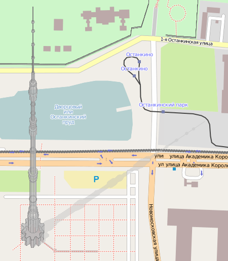
OpenStreetMap contributor Komяpa has found a way to render 3D
buildings with Mapnik. Famous Ostankino tower (drawn by Hind) looks
very real! It even has a shadow. Discussion in Russian and more
screenshots.
Find out more:
http://forum.openstreetmap.org/viewtopic.php?id=10342
http://wiki.openstreetmap.org/wiki/User:Jongleur/MultiLevel_Building_Shapes
This is a Featured image, which means that it has been identified as
one of the best examples of OpenStreetMap mapping, or that it provides
a useful illustration related to the OpenStreetMap project.
If you know another image of similar quality, you can nominate it at