With apologies to Randall.

With apologies to Randall.

Fugro Aerial Mapping A/S is a Danish aerial imagery company. Fugro
has shared their 40cm Danish photography with OpenStreetMap community
for tracing vector data in to OpenStreetMap
[Thanks to Peter Brodersen and Jonas Häggqvist for making this
happen]. See the project page for more details including how to start
using this aerial imagery for mapping in Denmark.

Banks banks banks. Not the banks of a river, but financial
institutions. I’ll just run out to the bank for a moment. But which
bank is closest and most convenient? Do you need a bank with
wheelchair access, or with drive through service? Or are you looking
for a late night automated teller machine? We can put all of this
information on the map and that is the Project of the Week. Map your
local banks.
http://wiki.openstreetmap.org/wiki/Project_of_the_week/2011/Jan_19
This is your Project of the Week. Make suggestions. Inspire other
mappers. What is it about contributing to OpenStreetMap that
interests you? Postboxes? Bowing alleys? Share your OpenStreetMap
interests by contributing a Project of the Week.
http://wiki.openstreetmap.org/wiki/Project_of_the_week/Proposals
Bank machine photo by Dave Stone http://www.flickr.com/photos/builtbydave/
is licensed CC-By-SA http://creativecommons.org/licenses/by-sa/2.0/deed.en_CA
01/11/2011 – 01/19/2011
Every week a lot of things are happening in the OpenStreetMap (OSM) world. It can be hard to keep track of all the different communication channels and don’t miss any important news. That’s why we’ve created a short summary of all the news here. Enjoy!
For more news, especially regarding new tags and wiki pages, you can check-out the community-updates over here.
Authors: Pascal, Jonas & Dennis.
We missed something? You want to help us collecting the news for next week’s issue?
You can contact us via mail or Twitter.
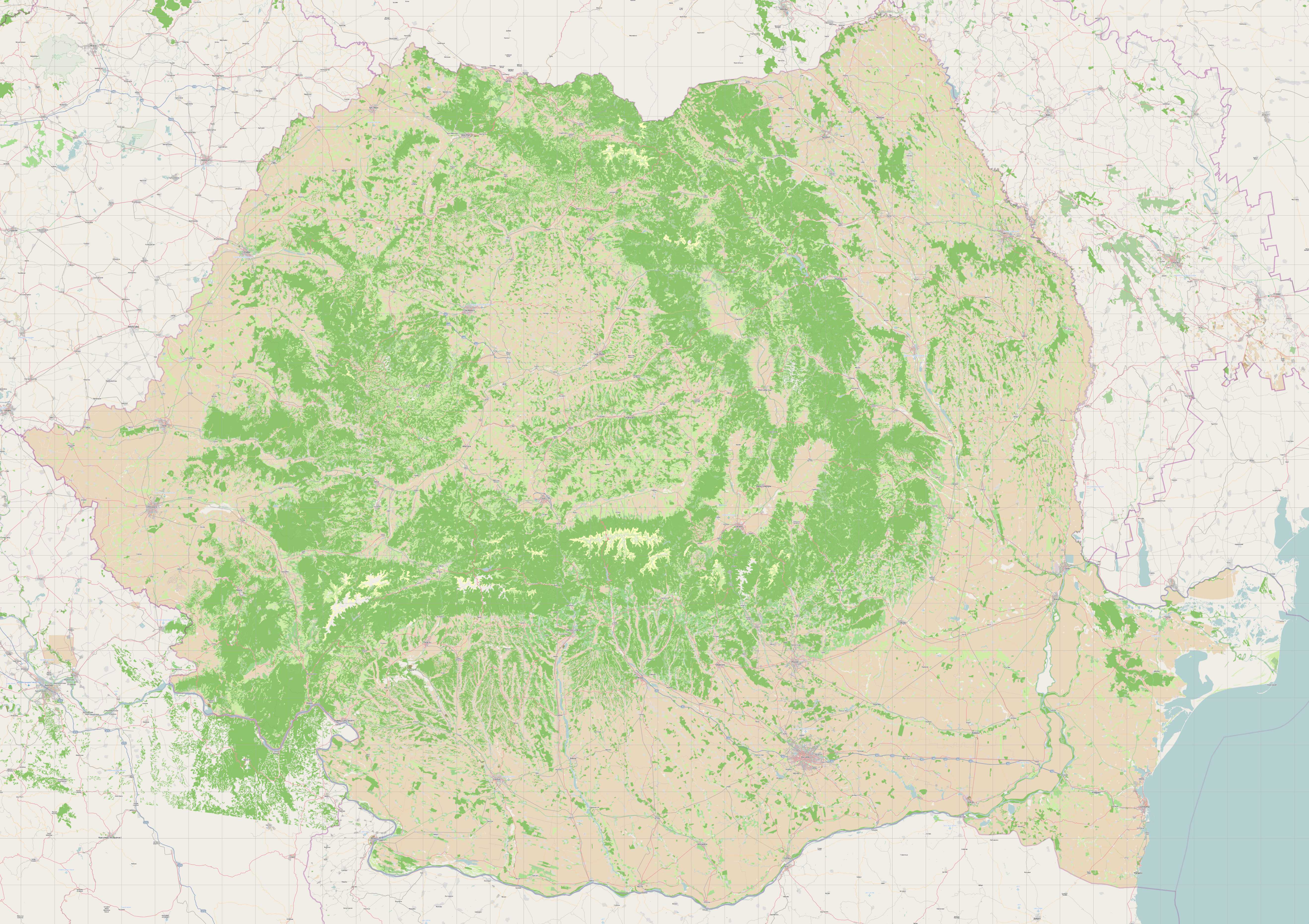
Romanian landuse – data from EEA comprises 100K polygons, imported to
OSM December 2010
This is a Featured image, which means that it has been identified as
one of the best examples of OpenStreetMap mapping, or that it provides
a useful illustration related to the OpenStreetMap project.
If you know another image of similar quality, you can nominate it at

Where can you go when you need to go? The Project of the Week is to
add public toilets to the map.
http://wiki.openstreetmap.org/wiki/Project_of_the_week/2011/Jan_12
This is your Project of the Week. Make suggestions. Inspire other
mappers. What is it about contributing to OpenStreetMap that
interests you? Postboxes? Bowing alleys? Share your OpenStreetMap
interests by contributing a Project of the Month.
http://wiki.openstreetmap.org/wiki/Project_of_the_week/Proposals
Book photo by Paul Downey http://www.flickr.com/photos/psd/
is licensed CC-By http://creativecommons.org/licenses/by/2.0/deed.en_CA
12/23/2010 – 01/10/2011
Every week a lot of things are happening in the OpenStreetMap (OSM) world. It can be hard to keep track of all the different communication channels and don’t miss any important news. That’s why we’ve created a short summary of all the news here. Enjoy!
For more news, especially regarding new tags and wiki pages, you can check-out the community-updates over here.
Authors: Pascal, Jonas, Brice & Dennis.
We missed something? You want to help us collecting the news for next week’s issue?
You can contact us via mail or Twitter.
There is a huge gap between passive and active OSM users. In most regions, the map is maintained by a small number of users. Not everyone who intends to improve the map is capable of doing so. OpenStreetMap editors require a learning curve, as editing a map is not intuitive.

However, there seems to be a much broader willingness to improve the map through the feedback channel. The GPS turn-by-turn navigation skobbler receives up to 1.000 suggestions for improvement per day. We have seized this suggestion and extended the skobbler feedback channel to an independent bug tool for the OpenStreetMap community: MapDust.com – a state-of the art bug tool.

Bugs can be accessed through the Geo-RSS feed and the MapDust JOSM plug-in
The integration of the feedback channel has significantly simplified providing bug reports for the consumer. The number of incoming suggestions was overwhelming, even if not all of the reports have been helpful or relevant. To date, the feedback channel has been focused on the consumer, and that this why many of the bug reports “got stuck in the channel”.
We are now working on the other – the mapper’s part – to create a Geo-RSS feed and a JOSM plug-in to distribute the bug reports to the location where they can be processed.

Why create a new tool if similar solutions exist?
We have seen that OpenStreetMap editors are very advanced. However, the tools for consumers to provide input have been neglected. Great editors like JOSM and Potlatch (2) exist as well as tools like the OSM Inspector. We want to provide a system where more input and contributions are received from people who only contribute on an occasional basis.
Filter allows a selective approach towards bug types
We simply wanted to increase the number of contributions by designing a slick and lean user interface. We see enormous potential to improve the map in many different aspects such as bus stops and house numbers.
We have received comments that the skobbler feedback channel contained bugs that are only very selectively relevant. Therefore, with the integration of filters, one can hide bugs that are not of interest.

The Geo-RSS feed
You can submit suggestions and change requests for a specific region by selecting the desired map view, setting the filters and pressing the “subscribe RSS feed” button.

Once subscribed, you are provided all new bugs that match the selected region and filters. Each feed post contains a small map view and the corresponding data as well as links to open the bugs directly in the JOSM or Potlatch editors.

The wish list
Most of the MapDust features have been documented in the Wiki. We have also included a section entitled “wish list”. If there is anything you would like to see changed or added, please add your request to the wish list.
We wish you a happy 2011 and happy bug fixing!
Your skobbler Team
I had the chance to have a chat with all the board members during our Pisa meeting. See Henk about OpenStreetMap, SOTM and the community.